Dangerous heat expands across the Desert Southwest, Plains, Mississippi Valley and Midwest. Critical fire weather for portions of the Intermountain West. Risk for severe thunderstorms and flash flooding across the Upper Midwest/Great Lakes, Ohio Valley, and portions of the mid-Atlantic. Active monsoonal moisture fuels thunderstorms over the Southwest. Hurricane Fausto in the Pacific, should weaken Read More >
Overview
|
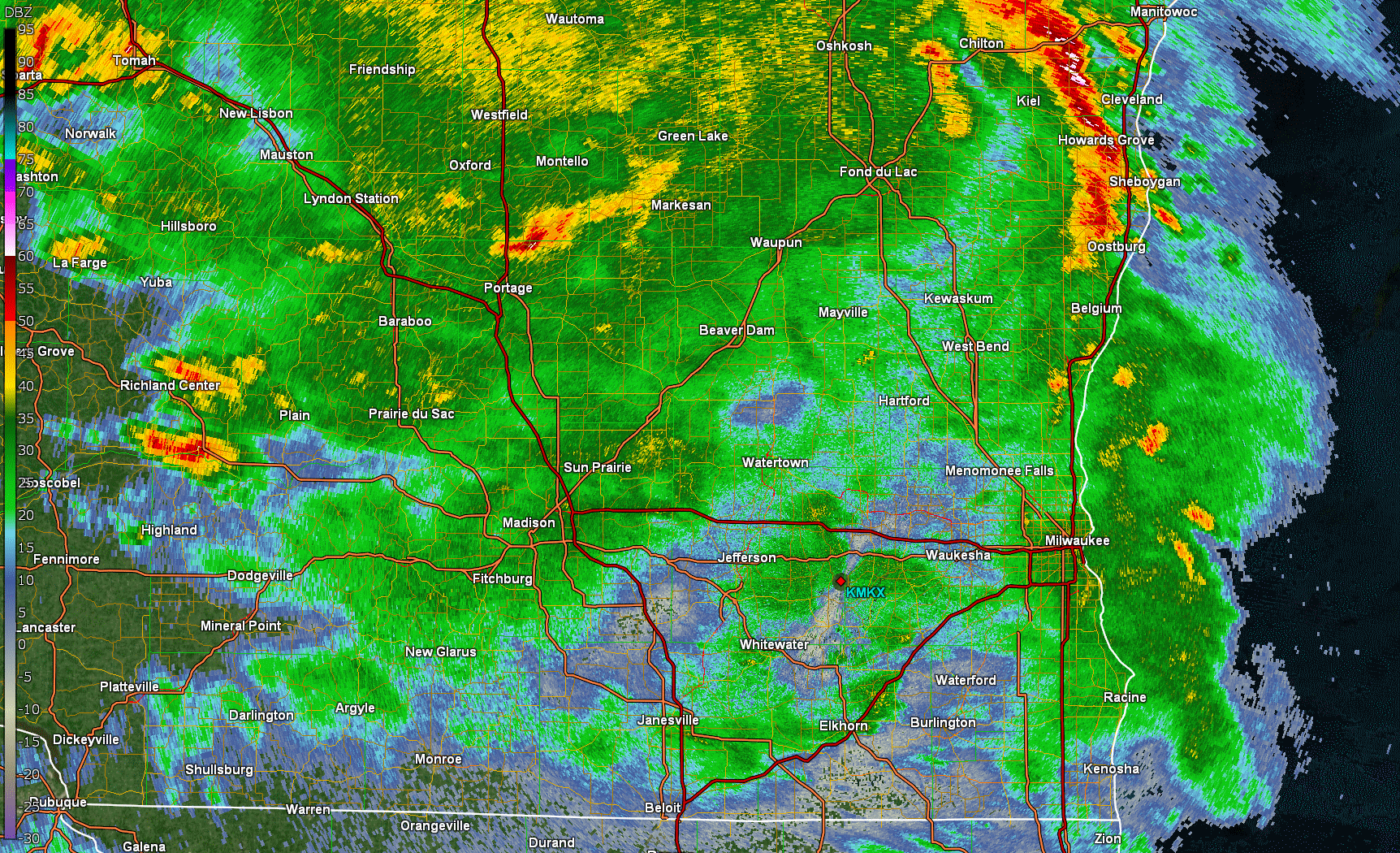
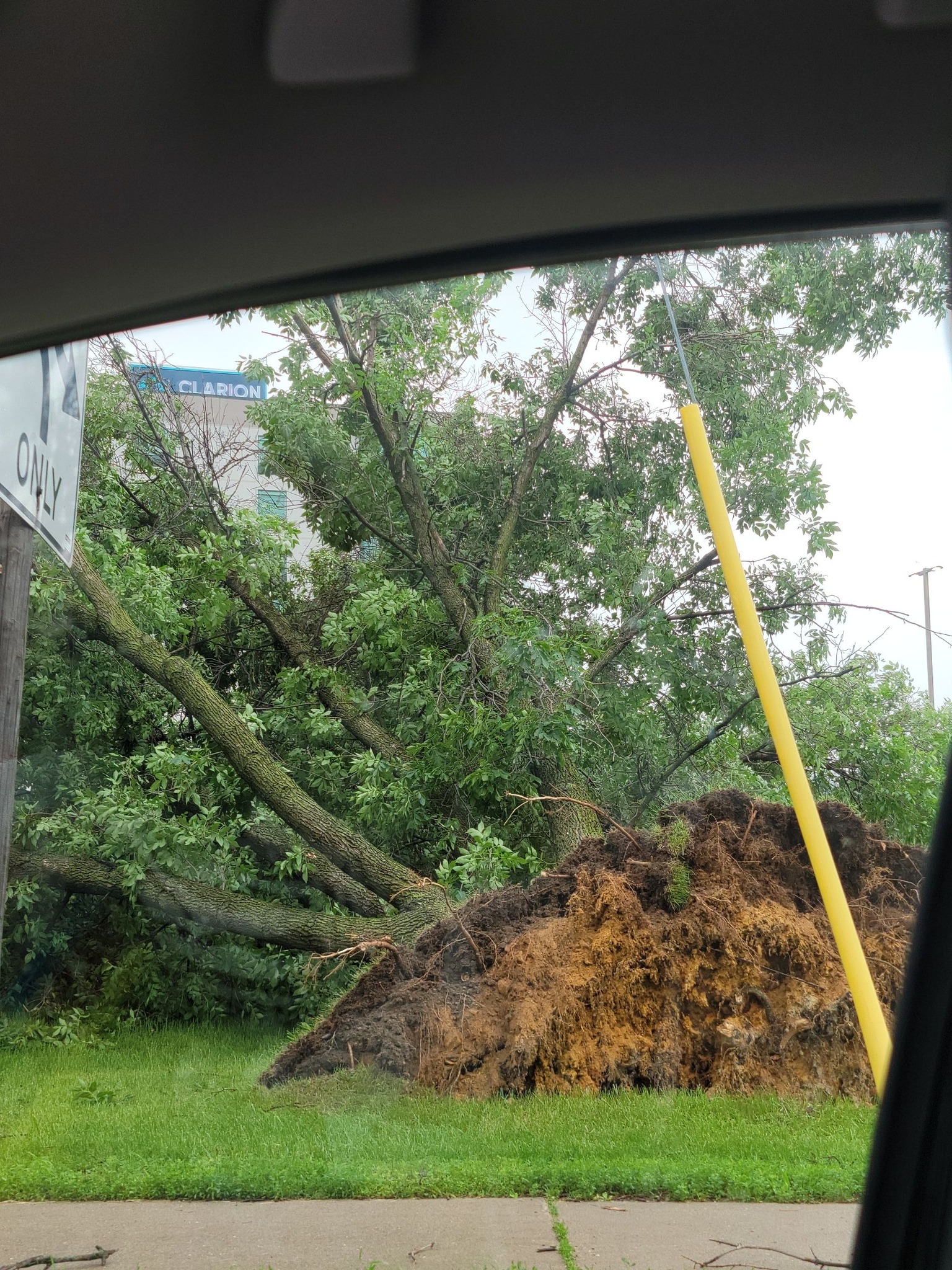
There was a bit of uncertainty Monday morning if we'd get any severe weather that day with the morning rain moving through. Would storms be able to tap into the strong instability and wind shear with a strong inversion in place? Well one lone storm put on a show for southern Wisconsin. The storm initially perked up along the Wisconsin River as it entered southern Sauk County and continued to intensify as it moved east southeast. This storm quickly developed a strong hail core that dropped 1 to 2 inch hail stones over those it its path. Wind became more of a threat as the storm evolved over Dane County. Once this core of winds developed it raced southeast into Jefferson, Waukesha, Milwaukee, and northern Racine Counties until it moved over Lake Michigan.
This storm continued to track southeast and eventually became part of a Derecho that impacted areas in Indiana, Ohio, and states to the southeast. For more information on Derechos check out SPC Derecho facts.
|
|
Wind & Hail:
Initially hail was the primary threat with the supercell as it quickly grew in intensity and height. The top of the storm reached just above 50,000 feet (over 9 miles) over the earth's surface. It developed an impressive hail core aloft which would produce 1 to 2 inch diameter hail from Dane County east into Milwaukee County. As the storm evolved, the cold pool intensified allowing stronger winds to reach the surface with the Madison area receiving the initial burst of winds that then raced eastward. You can see how this changed to storms structure in the radar loop above.
Wind
 |
 |
 |
 |
|
East Madison Photo from: Amanda Morgan |
Fitchburg Photo from: Tim Corcoran |
Johnson Creek Photo from: Staci Isbell |
Downtown Madison Photo from: Kiley E |
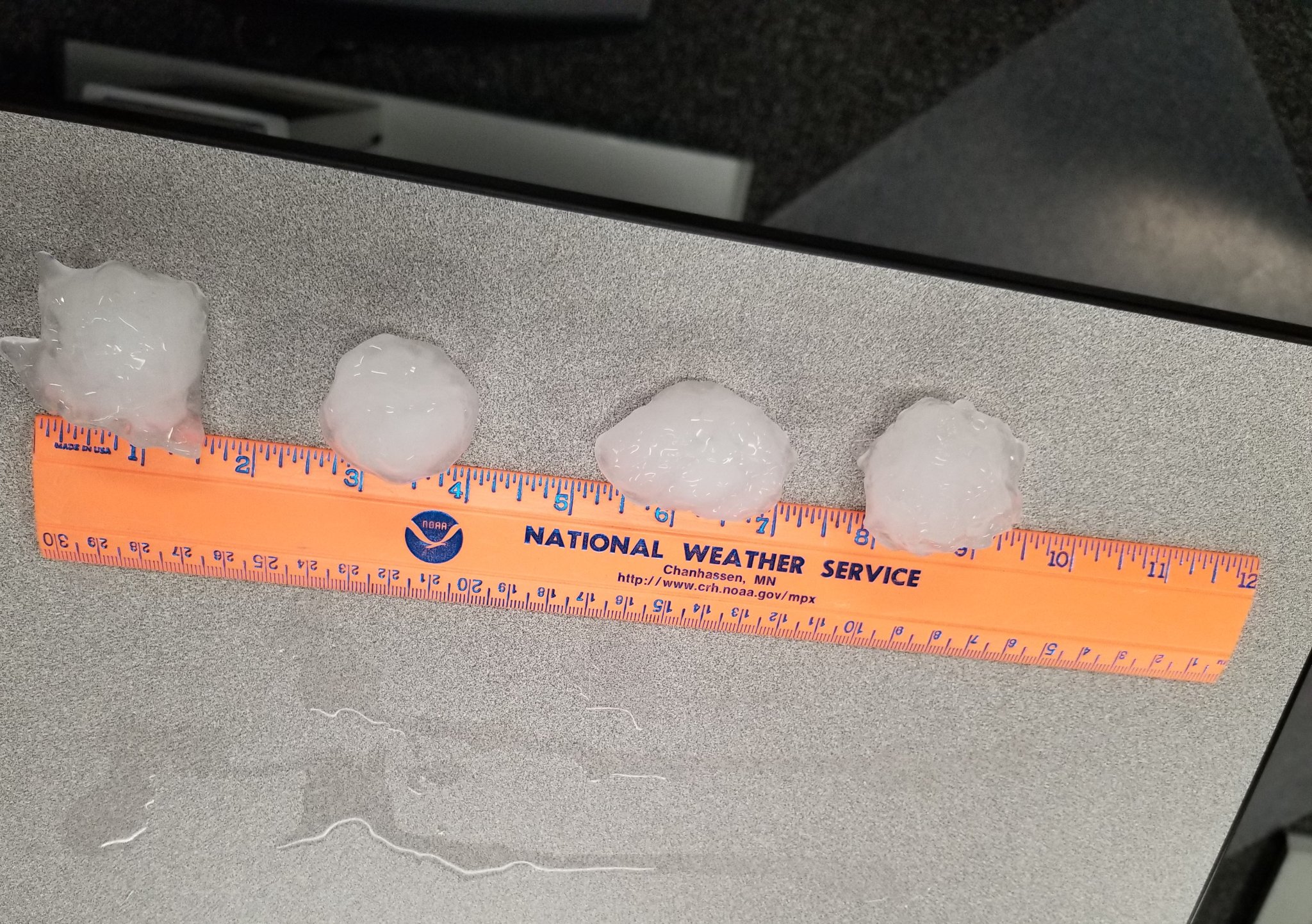
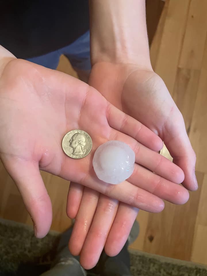
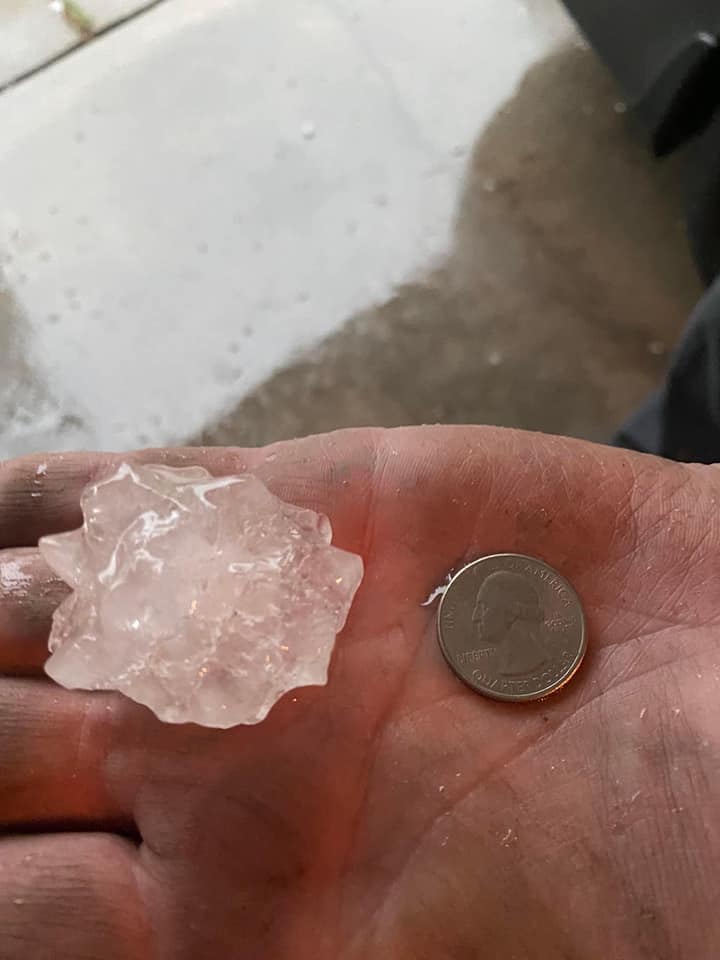
Hail
 |
 |
 |
 |
| 2 inch hail at the Milwaukee Office! |
Village of Deerfield Photo from: Andy Grosvold |
Sun Prairie Photo from: Donna Faulkner |
North Prairie Photo from: Monica Grossman |
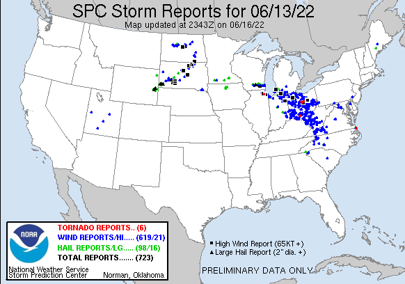
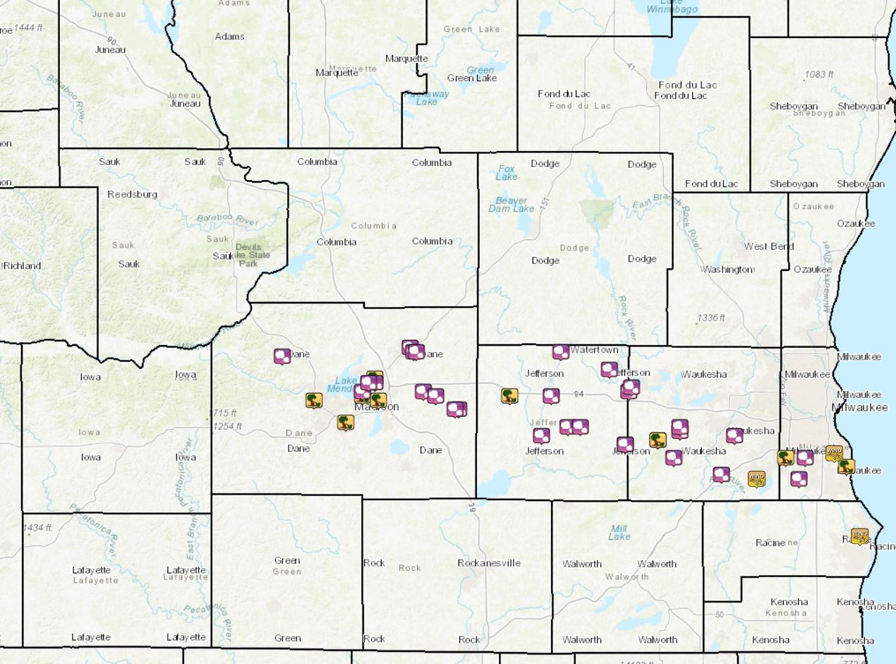
Storm Reports
PRELIMINARY LOCAL STORM REPORT...SUMMARY
NATIONAL WEATHER SERVICE MILWAUKEE/SULLIVAN WI
1008 PM CDT TUE JUN 14 2022
..TIME... ...EVENT... ...CITY LOCATION... ...LAT.LON...
..DATE... ....MAG.... ..COUNTY LOCATION..ST.. ...SOURCE....
..REMARKS..
0355 PM HAIL 2 WSW OCONOMOWOC 43.09N 88.54W
06/13/2022 M1.25 INCH WAUKESHA WI COCORAHS
CERTIFIED WEATHER OBSERVER.
0356 PM HAIL 2 WSW OCONOMOWOC 43.10N 88.53W
06/13/2022 U1.75 INCH WAUKESHA WI PUBLIC
REPORT FROM MPING: GOLF BALL (1.75 IN.).
0400 PM HAIL 3 SSE DOUSMAN 42.98N 88.45W
06/13/2022 M1.00 INCH WAUKESHA WI PUBLIC
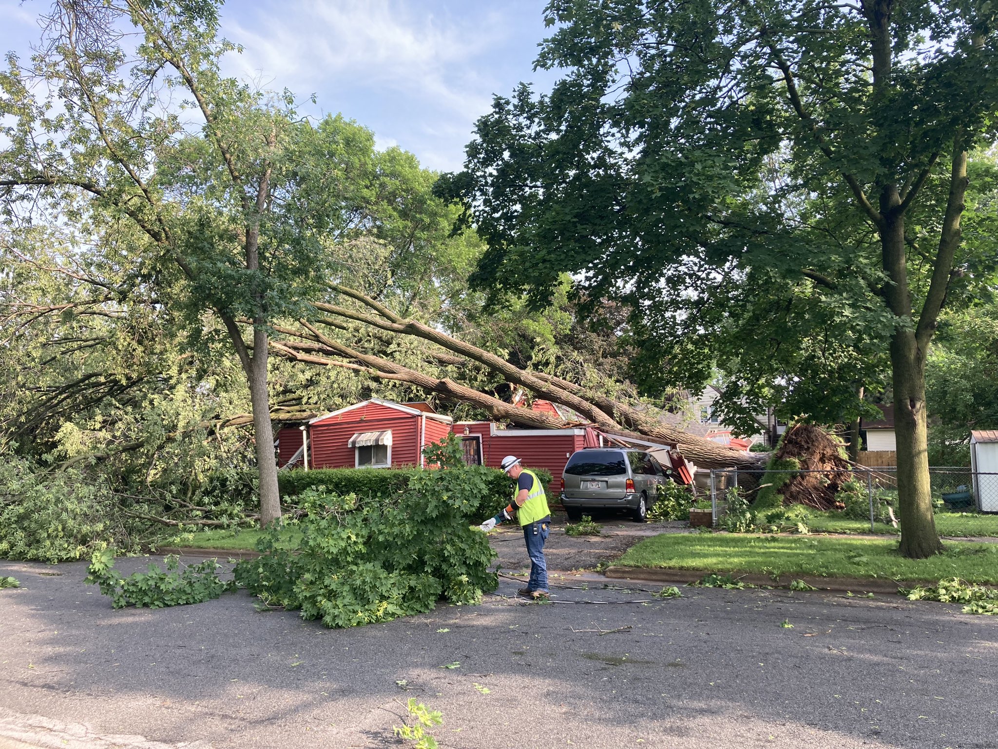
0400 PM TSTM WND DMG 3 SSE DOUSMAN 42.98N 88.45W
06/13/2022 WAUKESHA WI LAW ENFORCEMENT
WIDESPREAD REPORTS OF TREES AND WIRES DOWN
ACROSS MUCH OF WESTERN WAUKESHA COUNTY.
0402 PM HAIL NORTH PRAIRIE 42.94N 88.40W
06/13/2022 M1.75 INCH WAUKESHA WI PUBLIC
TIME EST FROM RADAR.
0403 PM HAIL WALES 43.00N 88.38W
06/13/2022 E1.25 INCH WAUKESHA WI PUBLIC
SIZE EST FROM SOCIAL MEDIA PIC. TIME EST
FROM RADAR.
0403 PM HAIL WALES 43.01N 88.38W
06/13/2022 M1.00 INCH WAUKESHA WI PUBLIC
FROM SOCIAL MEDIA PIC. TIME EST FROM RADAR.
0412 PM HAIL 3 NW BIG BEND 42.90N 88.25W
06/13/2022 E1.75 INCH WAUKESHA WI PUBLIC
REPORT IS FROM VERNON.
0415 PM TSTM WND GST 2 N MUSKEGO 42.89N 88.14W
06/13/2022 E60 MPH WAUKESHA WI PUBLIC
0416 PM HAIL 2 SE WAUKESHA 42.99N 88.21W
06/13/2022 M1.00 INCH WAUKESHA WI PUBLIC
0450 PM MARINE TSTM WIND 2 WSW NORTH BAY 42.76N 87.82W
06/13/2022 M43 MPH RACINE WI OFFICIAL NWS OBS
0420 PM TSTM WND DMG HALES CORNERS 42.94N 88.05W
06/13/2022 MILWAUKEE WI PUBLIC
TREE DAMAGE. TIME EST BY RADAR.
0426 PM HAIL GREENDALE 42.94N 87.99W
06/13/2022 E1.25 INCH MILWAUKEE WI PUBLIC
SIZE EST FROM SOCIAL MEDIA PIC.
0430 PM TSTM WND DMG 1 ENE SOUTH MILWAUKEE 42.92N 87.85W
06/13/2022 MILWAUKEE WI BROADCAST MEDIA
NUMEROUS TREES AND TREE LIMBS DOWN AT GRANT
PARK IN MILWAUKEE.
0430 PM TSTM WND DMG SOUTH MILWAUKEE 42.92N 87.86W
06/13/2022 MILWAUKEE WI PUBLIC
NUMEROUS TREES AND BRANCHES DOWN. TIME EST
FROM RADAR.
0430 PM HAIL FRANKLIN 42.89N 88.01W
06/13/2022 M1.25 INCH MILWAUKEE WI PUBLIC
0439 PM TSTM WND GST 2 SW SAINT FRANCIS 42.95N 87.90W
06/13/2022 M59 MPH MILWAUKEE WI OFFICIAL NWS OBS
AT MKE. ALSO HAD HALF INCH HAIL.
0325 PM TSTM WND DMG LAKE MILLS 43.08N 88.91W
06/13/2022 JEFFERSON WI LAW ENFORCEMENT
WIDESPREAD TREE DAMAGE ACROSS LAKE MILLS.
TIME EST FROM RADAR.
0334 PM HAIL 1 S JEFFERSON 42.99N 88.81W
06/13/2022 U1.75 INCH JEFFERSON WI PUBLIC
REPORT FROM MPING: GOLF BALL (1.75 IN.).
0335 PM HAIL JOHNSON CREEK 43.08N 88.78W
06/13/2022 E1.75 INCH JEFFERSON WI NWS EMPLOYEE
50-60 MPH GUSTS.
0340 PM HAIL 4 E JEFFERSON 43.01N 88.73W
06/13/2022 E1.75 INCH JEFFERSON WI PUBLIC
0342 PM HAIL 2 SW WATERTOWN 43.18N 88.75W
06/13/2022 E1.25 INCH JEFFERSON WI NWS EMPLOYEE
0344 PM HAIL 5 W SULLIVAN 43.01N 88.69W
06/13/2022 E1.75 INCH JEFFERSON WI TRAINED SPOTTER
1 E OF HELENVILLE.
0347 PM HAIL IXONIA 43.14N 88.60W
06/13/2022 E1.25 INCH JEFFERSON WI PUBLIC
SIZE EST FROM SOCIAL MEDIA PIC. TIME EST
FROM RADAR.
0355 PM HAIL 4 SSE SULLIVAN 42.97N 88.55W
06/13/2022 M2.00 INCH JEFFERSON WI OFFICIAL NWS OBS
LARGEST STONE WAS 2 INCHES...MEASURED.
CORRECTS PREVIOUS HAIL REPORT FROM 4 SSE
SULLIVAN. AT WFO MKX.
0247 PM HAIL 4 NE CROSS PLAINS 43.17N 89.62W
06/13/2022 U1.00 INCH DANE WI PUBLIC
REPORT FROM MPING: QUARTER (1.00 IN.).
0250 PM TSTM WND DMG 3 SSW MIDDLETON 43.07N 89.52W
06/13/2022 DANE WI 911 CALL CENTER
NUMEROUS REPORTS OF TREES AND WIRES DOWN
ALONG WITH BLOWN TRANSFORMERS ACROSS THE
WESTERN PORTION OF MADISON AND MIDDLETON.
0253 PM TSTM WND DMG 2 ENE MAPLE BLUFF 43.12N 89.33W
06/13/2022 DANE WI EMERGENCY MNGR
ROOF DAMAGE TO AN APARTMENT COMPLEX ON
WRIGHT STREET. TIME EST BY RADAR.
0255 PM TSTM WND DMG 1 E MADISON 43.08N 89.37W
06/13/2022 DANE WI PUBLIC
NUMEROUS TREES AND POWERLINES DOWN. DEBRIS
FLYING PAST WINDOWS ON 8TH STORY OF OFFICE
BUILDING.
0257 PM TSTM WND DMG 1 NNE MONONA 43.07N 89.32W
06/13/2022 DANE WI TRAINED SPOTTER
NUMEROUS TREES AND POWER POLES DOWN NEAR THE
MONONA GOLF COURSE. LARGE LIMBS SNAPPED OFF
TREES.
0300 PM HAIL 1 ENE MADISON 43.09N 89.37W
06/13/2022 U1.25 INCH DANE WI PUBLIC
REPORT FROM MPING: HALF DOLLAR (1.25 IN.).
0302 PM HAIL 2 E MAPLE BLUFF 43.11N 89.33W
06/13/2022 M1.00 INCH DANE WI TRAINED SPOTTER
0302 PM HAIL 1 E MAPLE BLUFF 43.11N 89.35W
06/13/2022 U1.25 INCH DANE WI PUBLIC
REPORT FROM MPING: HALF DOLLAR (1.25 IN.).
0305 PM HAIL 1 ENE SUN PRAIRIE 43.19N 89.22W
06/13/2022 E1.25 INCH DANE WI PUBLIC
MPING REPORT.
0308 PM HAIL 1 E SUN PRAIRIE 43.18N 89.21W
06/13/2022 E2.00 INCH DANE WI PUBLIC
ESTIMATED 2.25 INCH FROM SOCIAL MEDIA IMAGE.
0308 PM HAIL 2 E SUN PRAIRIE 43.18N 89.20W
06/13/2022 U1.50 INCH DANE WI PUBLIC
REPORT FROM MPING: PING PONG BALL (1.50
IN.).
0308 PM HAIL 1 ENE COTTAGE GROVE 43.09N 89.18W
06/13/2022 E1.25 INCH DANE WI PUBLIC
MPING.
0310 PM HAIL DEERFIELD 43.05N 89.07W
06/13/2022 E1.50 INCH DANE WI PUBLIC
SIZE EST FROM SOCIAL MEDIA PIC.
0310 PM HAIL 3 ESE COTTAGE GROVE 43.08N 89.14W
06/13/2022 U1.50 INCH DANE WI PUBLIC
REPORT FROM MPING: PING PONG BALL (1.50
IN.).
0315 PM HAIL DEERFIELD 43.05N 89.08W
06/13/2022 M1.50 INCH DANE WI PUBLIC
PICTURE ON SOCIAL MEDIA.
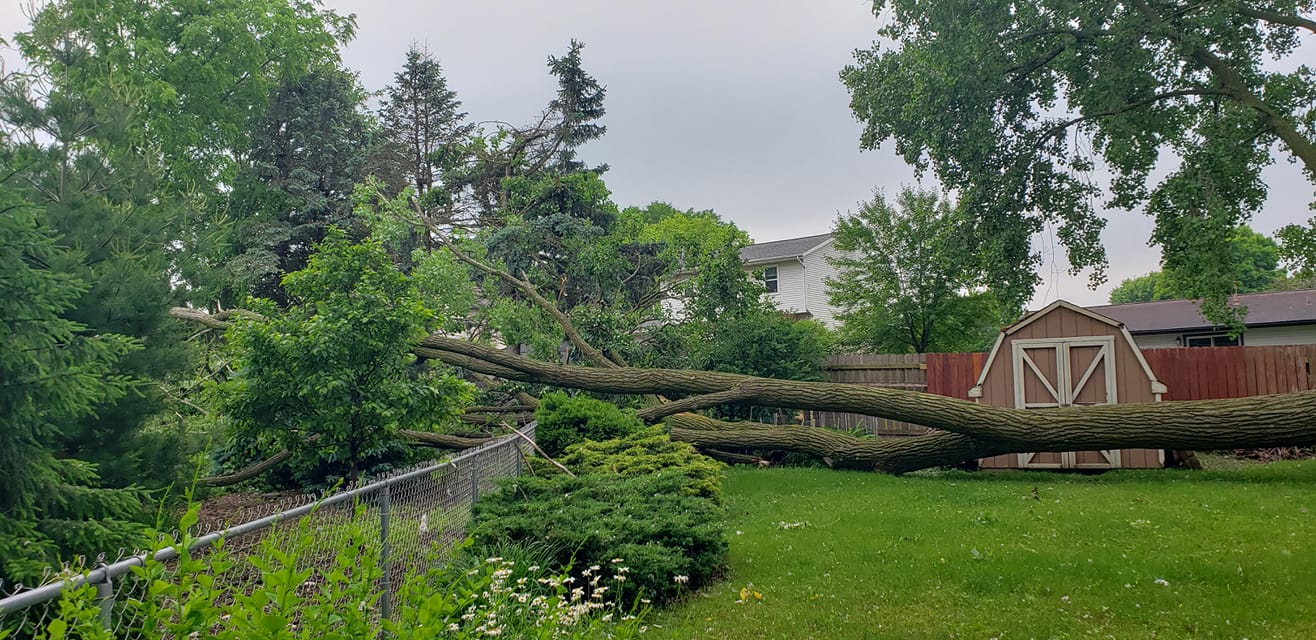
0355 PM TSTM WND DMG 2 N FITCHBURG 43.02N 89.42W
06/13/2022 DANE WI PUBLIC
LARGE TREE SNAPPED NEAR BASE. TIME EST FROM
RADAR.
Rain Reports
Public Information Statement...Updated
National Weather Service Milwaukee/Sullivan WI
859 PM CDT Mon Jun 13 2022

...PRECIPITATION REPORTS...

Location                     Amount    Time/Date       Lat/Lon

...Wisconsin...

...Columbia County...
Portage                      0.36 in   0546 PM 06/13   43.61N/89.54W
Lodi                         0.24 in   0548 PM 06/13   43.38N/89.55W
Portage                      0.14 in   0535 PM 06/13   43.54N/89.47W
Pardeeville                  0.04 in   0314 PM 06/13   43.56N/89.31W

...Dane County...
DeForest                     1.63 in   0545 PM 06/13   43.25N/89.36W
Waunakee                     1.37 in   0547 PM 06/13   43.21N/89.38W
Deforest                     1.30 in   0546 PM 06/13   43.24N/89.33W
Sun Prairie                  1.08 in   0545 PM 06/13   43.19N/89.22W
MIDDLETON                    0.65 in   0546 PM 06/13   43.14N/89.57W
Madison-Dane County Airport  0.48 in   0521 PM 06/13   43.13N/89.35W
Black Earth                  0.42 in   0545 PM 06/13   43.13N/89.75W
Monona                       0.38 in   0549 PM 06/13   43.06N/89.33W
Sun Prairie                  0.35 in   0548 PM 06/13   43.10N/89.33W
Deerfield                    0.34 in   0549 PM 06/13   43.08N/89.07W
Middleton                    0.31 in   0515 PM 06/13   43.12N/89.53W
Vermont Township             0.12 in   0545 PM 06/13   43.08N/89.79W
4 SE Cross Plains            0.09 in   0542 PM 06/13   43.06N/89.60W
Belleville                   0.07 in   0546 PM 06/13   42.91N/89.51W
Oregon                       0.06 in   0545 PM 06/13   42.92N/89.39W
Brooklyn                     0.06 in   0341 PM 06/13   42.87N/89.50W
Cottage Grove                0.03 in   0300 PM 06/13   43.06N/89.24W
1 N Fitchburg                0.02 in   0535 PM 06/13   43.01N/89.42W

...Dodge County...
Beaver Dam                   0.20 in   0550 PM 06/13   43.45N/88.83W
Horicon                      0.17 in   0430 PM 06/13   43.57N/88.61W
Juneau                       0.14 in   0535 PM 06/13   43.42N/88.70W

...Fond du Lac County...
Fond Du Lac Airport          0.30 in   0453 PM 06/13   43.77N/88.48W
1 ESE Fond Du Lac            0.23 in   0535 PM 06/13   43.78N/88.42W
Campbellsport                0.18 in   0545 PM 06/13   43.59N/88.38W

...Green County...
New Glarus                   0.04 in   0547 PM 06/13   42.82N/89.64W
Albany River Gage            0.02 in   0515 PM 06/13   42.71N/89.44W
Monroe                       0.01 in   0535 PM 06/13   42.62N/89.60W

...Green Lake County...
Berlin                       0.47 in   0535 PM 06/13   43.98N/88.94W

...Jefferson County...
Waterloo                     0.76 in   0534 PM 06/13   43.19N/88.99W
Watertown                    0.04 in   0335 PM 06/13   43.17N/88.72W

...Kenosha County...
Kenosha Airport              0.02 in   0530 PM 06/13   42.60N/87.93W
Pleasant Prairie             0.01 in   0545 PM 06/13   42.56N/87.91W

...Milwaukee County...
West Allis                   1.42 in   0550 PM 06/13   43.00N/88.02W
Greendale                    1.20 in   0545 PM 06/13   42.94N/87.98W
Milwaukee                    1.15 in   0545 PM 06/13   42.98N/88.00W
Cudahy                       1.12 in   0545 PM 06/13   42.96N/87.85W
1 N West Allis               0.85 in   0535 PM 06/13   43.03N/88.03W
1 N West Milwaukee           0.55 in   0535 PM 06/13   43.03N/87.97W
Milwaukee                    0.52 in   0540 PM 06/13   42.99N/87.88W
Oak Creek                    0.33 in   0430 PM 06/13   42.90N/87.91W
1 NNW Whitefish Bay          0.18 in   0535 PM 06/13   43.13N/87.91W
Brown Deer                   0.15 in   0543 PM 06/13   43.17N/87.99W
Brown Deer                   0.09 in   0535 PM 06/13   43.18N/87.96W
River Hills                  0.08 in   0534 PM 06/13   43.18N/87.94W
Milwaukee-Gen Mitchell Arpt  1.33 in   0700 PM 06/13   42.95N/87.90W

...Ozaukee County...
Cedarburg                    0.08 in   0547 PM 06/13   43.29N/88.06W
Port Washington              0.07 in   0534 PM 06/13   43.40N/87.88W
Mequon                       0.07 in   0545 PM 06/13   43.20N/87.93W
Cedarburg                    0.06 in   0535 PM 06/13   43.29N/87.99W
Mequon                       0.05 in   0546 PM 06/13   43.24N/87.96W

...Racine County...
Racine-Batten Airport        0.02 in   0524 PM 06/13   42.77N/87.82W
Racine                       0.01 in   0535 PM 06/13   42.72N/87.80W
Yorkville                    0.01 in   0545 PM 06/13   42.75N/88.04W
1.0 SE Wind Lake             0.01 in   0515 PM 06/13   42.81N/88.14W

...Rock County...
Edgerton                     0.04 in   0545 PM 06/13   42.79N/89.06W

...Sauk County...
Baraboo                      0.18 in   0545 PM 06/13   43.47N/89.73W
Lone Rock-Airport            0.17 in   0456 PM 06/13   43.22N/90.18W
Dells Baraboo                0.16 in   0535 PM 06/13   43.52N/89.77W

...Sheboygan County...
Howards Grove                0.43 in   0545 PM 06/13   43.83N/87.83W
Howards Grove                0.39 in   0535 PM 06/13   43.84N/87.82W
Plymouth                     0.38 in   0545 PM 06/13   43.75N/87.97W
Sheboygan-Airport            0.36 in   0453 PM 06/13   43.78N/87.85W
Howards Grove                0.36 in   0546 PM 06/13   43.82N/87.84W
Sheboygan                    0.34 in   0545 PM 06/13   43.78N/87.77W
Millhome 1 ESE               0.30 in   0534 PM 06/13   43.89N/87.94W
Random Lake                  0.27 in   0535 PM 06/13   43.55N/87.97W
Oostburg                     0.11 in   0533 PM 06/13   43.62N/87.79W
Random Lake                  0.10 in   0550 PM 06/13   43.55N/87.95W
1 NNW Sheboygan              0.01 in   0535 PM 06/13   43.78N/87.72W

...Walworth County...
East Troy                    0.01 in   0546 PM 06/13   42.84N/88.39W
Mukwonago                    0.01 in   0545 PM 06/13   42.84N/88.36W

...Washington County...
Colgate                      0.33 in   0545 PM 06/13   43.20N/88.16W
Colgate                      0.19 in   0545 PM 06/13   43.20N/88.19W
West Bend                    0.09 in   0545 PM 06/13   43.45N/88.26W
Jackson                      0.08 in   0545 PM 06/13   43.32N/88.17W
West Bend                    0.08 in   0549 PM 06/13   43.40N/88.20W
Jackson                      0.08 in   0549 PM 06/13   43.29N/88.11W
Newburg                      0.06 in   0535 PM 06/13   43.43N/88.05W
Allenton                     0.06 in   0545 PM 06/13   43.40N/88.37W
West Bend                    0.06 in   0549 PM 06/13   43.41N/88.15W
Cudahy                       0.06 in   0545 PM 06/13   43.44N/88.05W
West Bend                    0.04 in   0534 PM 06/13   43.42N/88.19W

...Waukesha County...
Delafield                    1.74 in   0548 PM 06/13   43.02N/88.37W
Waukesha                     1.33 in   0545 PM 06/13   43.00N/88.21W
New Berlin                   1.26 in   0545 PM 06/13   42.97N/88.07W
Pewaukee                     1.22 in   0550 PM 06/13   43.04N/88.22W
Muskego                      0.66 in   0547 PM 06/13   42.89N/88.14W
Brookfield                   0.59 in   0545 PM 06/13   43.06N/88.14W
2 NNE Chenequa               0.55 in   0535 PM 06/13   43.16N/88.37W
North Prairie                0.52 in   0550 PM 06/13   42.93N/88.39W
2 WNW Muskego                0.49 in   0530 PM 06/13   42.90N/88.16W
Brookfield                   0.48 in   0548 PM 06/13   43.09N/88.15W
Brookfield                   0.44 in   0546 PM 06/13   43.09N/88.07W
1 SSE Lannon                 0.42 in   0530 PM 06/13   43.13N/88.16W
Butler                       0.41 in   0535 PM 06/13   43.11N/88.07W
Eagle                        0.02 in   0550 PM 06/13   42.85N/88.44W

Observations are collected from a variety of sources with varying
equipment and exposures. We thank all volunteer weather observers
for their dedication. Not all data listed are considered official.
 |
Media use of NWS Web News Stories is encouraged! Please acknowledge the NWS as the source of any news information accessed from this site. |
|