
Widespread, life-threatening considerable flash flooding is expected in south-central Texas through at least Friday. Catastrophic river flooding and rapid rises on small streams, arroyos, and typically dry washes are expected in the Texas Hill Country. Wildfire smoke is impacting air quality across much of the Great Lakes region into the Northeast U.S. with Air Quality Alerts in effect. Read More >
|
Just before 8 PM CDT on August 2nd, thunderstorms developed along a convergence zone near the lake and given the lack of shear and high precipitable water values around 1.0-1.5 inches, storms stalled over southern Milwaukee County for a few hours. This resulted in a prolonged period of very heavy rainfall and localized flash flooding that swamped vehicles and inundated roadways across southern Milwaukee County. Portions of the area saw around 3.0 inches of rainfall with pockets of higher amounts approaching 5.0-6.0 inches. However, due to precipitation being 0.5-1.0 inch below average for the week prior, it helped mitigate the flooding impacts from being worse. Nonetheless, two flash flood warnings were issued for portions of southern Milwaukee and northern Racine counties. Eventually, around 10:30 PM CDT the stall showers finally began to move south into Racine and Kenosha counties where they were able to see some of the action. These areas to the south saw upwards of 1.0-3.0 inches. |
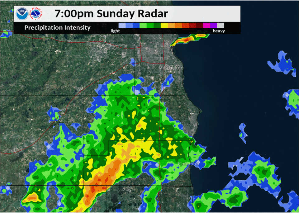 Radar reflectivity loop of the storms that produced flash flooding/heavy rains in southeast WI on August 2, 2020 |
Flash Flooding:
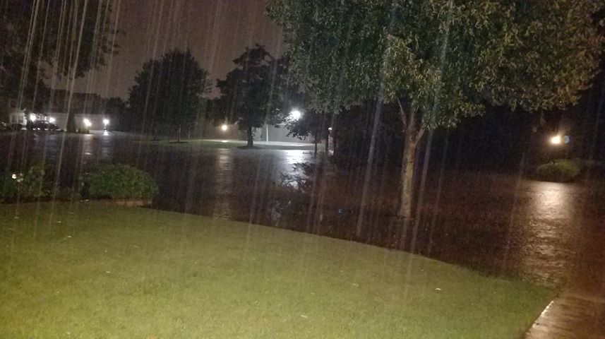
These fairly localized storms stalled out across southern Milwaukee County and produced heavy rainfall. Around 9 PM CDT, Mitchell Airport recorded 0.76" of rainfall in 10 minutes, while 2.56" of rainfall in 30 minutes (between 8:45 PM to 9:15 PM) was observed at 97th Street north of Greenfield! Elsewhere saw 1.0-2.5" of rainfall in hour across southern portions of Milwaukee County. This resulted in numerous reports of flash flooding from West Allis, Greenfield, Oak Creek, Franklin, and surrounding areas. Several streets were closed including portions of I-43, vehicles were submerged, and backyards and basements were flooded.
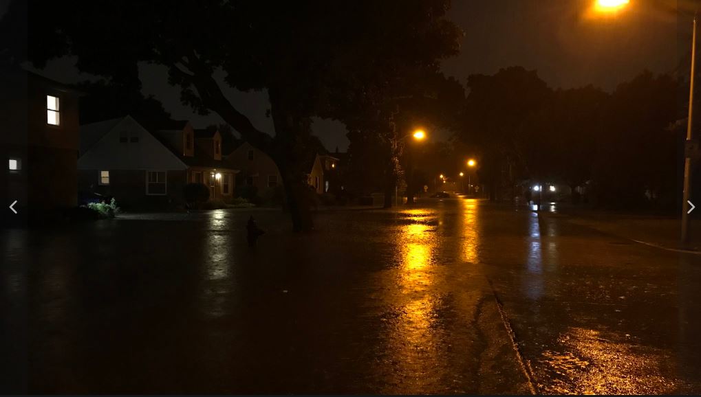
Flooding in Southern Milwaukee County
A few photos of the extent of the flash flooding/heavy rainfall.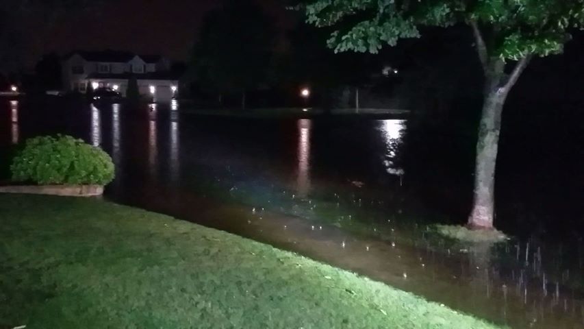 |
 |
 |
 |
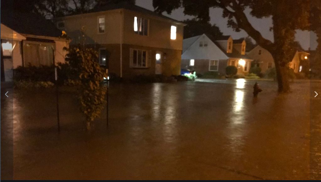
| Flooding in Oak Creek Courtesy of Chris Keske | Flooding in Oak Creek Courtesy of Chris Keske | Flooding around Honey Creek in West Allis Courtesy of Brett Lemoine | Flooding around Honey Creek in West Allis Courtesy of Brett Lemoine |
Additional Impacts
Additional reports of impacts from the flash flooding/heavy rainfall.
|
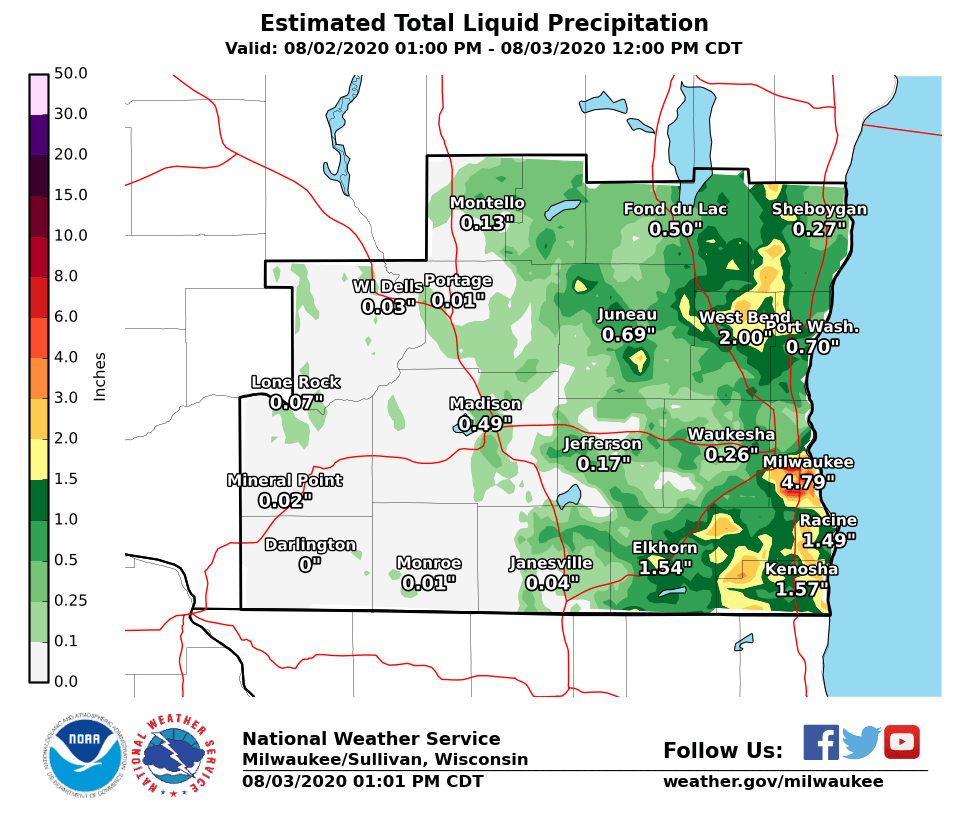
Rainfall Totals:
 |
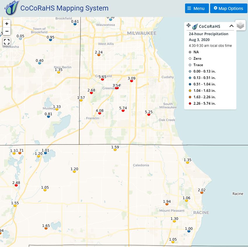 |
| Estimated Rainfall Totals for August 2, 2020 | CoCoRaHS 24 hr Rainfall Reports for August 2, 2020 |
Storm Reports
PRELIMINARY LOCAL STORM REPORT...SUMMARY
NATIONAL WEATHER SERVICE MILWAUKEE/SULLIVAN WI
1132 AM CDT MON AUG 3 2020

..TIME...   ...EVENT...      ...CITY LOCATION...     ...LAT.LON...
..DATE...   ....MAG....      ..COUNTY LOCATION..ST.. ...SOURCE....
            ..REMARKS..

0942 AM     HEAVY RAIN       2 S KEWASKUM            43.50N 88.23W
08/03/2020  M3.50 INCH       WASHINGTON         WI   PUBLIC

            PUBLIC REPORT RELAYED VIA BROADCAST MEDIA.

0938 AM     HEAVY RAIN       1 N GREENFIELD          42.98N 88.00W
08/03/2020  M6.40 INCH       MILWAUKEE          WI   PUBLIC

            PUBLIC REPORT RELAYED VIA BROADCAST MEDIA.

0825 AM     HEAVY RAIN       NEWBURG                 43.43N 88.05W
08/03/2020  M2.09 INCH       WASHINGTON         WI   MESONET

            MESONET STATION NWSTJ NEWBURG.

0824 AM     HEAVY RAIN       1 N PORT WASHINGTON     43.40N 87.88W
08/03/2020  M1.31 INCH       OZAUKEE            WI   MESONET

            MESONET STATION PTWSH PORT WASHINGTON.

0824 AM     HEAVY RAIN       SHOREWOOD               43.09N 87.88W
08/03/2020  M1.24 INCH       MILWAUKEE          WI   MESONET

            MESONET STATION SORWD SHOREWOOD.

0816 AM     HEAVY RAIN       1 SE SAINT FRANCIS      42.97N 87.86W
08/03/2020  M2.49 INCH       MILWAUKEE          WI   MESONET

            MESONET STATION FW2905 CUDAHY.

0815 AM     HEAVY RAIN       2 ENE TWIN LAKES        42.53N 88.22W
08/03/2020  M1.65 INCH       KENOSHA            WI   MESONET

            MESONET STATION DW6766 BASSETT.

0800 AM     HEAVY RAIN       1 WSW ELKHORN           42.67N 88.57W
08/03/2020  M2.46 INCH       WALWORTH           WI   COCORAHS

            COCORAHS STATION WI-WW-23 ELKHORN 1.5 WSW.

0743 AM     HEAVY RAIN       2 SW HALES CORNERS      42.92N 88.07W
08/03/2020  M1.57 INCH       MILWAUKEE          WI   PUBLIC


0731 AM     HEAVY RAIN       3 WSW BROOKFIELD        43.05N 88.18W
08/03/2020  M1.41 INCH       WAUKESHA           WI   CO-OP OBSERVER

            CO-OP OBSERVER STATION BFDW3 2.9 W
            BROOKFIELD.

0715 AM     HEAVY RAIN       2 SE BIG BEND           42.85N 88.18W
08/03/2020  M1.04 INCH       WAUKESHA           WI   TRAINED SPOTTER


0705 AM     HEAVY RAIN       1 ESE BROWNS LAKE       42.69N 88.21W
08/03/2020  M1.89 INCH       RACINE             WI   MESONET

            MESONET STATION FW4342 BURLINGTON.

0700 AM     HEAVY RAIN       2 ENE FRANKLIN          42.90N 87.97W
08/03/2020  M5.74 INCH       MILWAUKEE          WI   COCORAHS

            COCORAHS STATION WI-MW-28 FRANKLIN 2.4 ENE.

0700 AM     HEAVY RAIN       1 ENE GREENDALE         42.94N 87.98W
08/03/2020  M3.54 INCH       MILWAUKEE          WI   COCORAHS

            COCORAHS STATION WI-MW-23 GREENDALE 1.0 ENE.

0700 AM     HEAVY RAIN       1 SE SOUTH MILWAUKEE    42.90N 87.85W
08/03/2020  M3.31 INCH       MILWAUKEE          WI   CO-OP OBSERVER

            CO-OP OBSERVER STATION SEEW3 SOUTH
            MILWAUKEE-WWTP.

0700 AM     HEAVY RAIN       1 SE HALES CORNERS      42.93N 88.04W
08/03/2020  M2.68 INCH       MILWAUKEE          WI   COCORAHS

            COCORAHS STATION WI-MW-33 HALES CORNERS 0.7
            SE.

0700 AM     HEAVY RAIN       NORTH BAY               42.76N 87.78W
08/03/2020  M2.02 INCH       RACINE             WI   COCORAHS

            COCORAHS STATION WI-RC-32 RACINE 2.6 NNE.

0700 AM     HEAVY RAIN       1 W BROWNS LAKE         42.69N 88.26W
08/03/2020  M1.94 INCH       RACINE             WI   COCORAHS

            COCORAHS STATION WI-RC-27 BURLINGTON 1.4 NE.

0700 AM     HEAVY RAIN       1 W ALLENTON            43.42N 88.35W
08/03/2020  M1.91 INCH       WASHINGTON         WI   CO-OP OBSERVER

            CO-OP OBSERVER STATION ALLW3 ALLENTON.

0700 AM     HEAVY RAIN       2 WNW KEWASKUM          43.53N 88.27W
08/03/2020  M1.83 INCH       WASHINGTON         WI   COCORAHS

            COCORAHS STATION WI-WS-4 KEWASKUM 1.8 WNW.

0700 AM     HEAVY RAIN       4 SSW KENOSHA           42.52N 87.84W
08/03/2020  M1.78 INCH       KENOSHA            WI   COCORAHS

            COCORAHS STATION WI-KN-14 PLEASANT PRAIRIE
            2.1 E.

0700 AM     HEAVY RAIN       3 NW CALEDONIA          42.83N 87.99W
08/03/2020  M1.59 INCH       RACINE             WI   COCORAHS

            COCORAHS STATION WI-RC-7 CALEDONIA 3.6 WNW.

0700 AM     HEAVY RAIN       ROCHESTER               42.74N 88.22W
08/03/2020  M1.55 INCH       RACINE             WI   COCORAHS

            COCORAHS STATION WI-RC-25 ROCHESTER 0.2 SE.

0700 AM     HEAVY RAIN       2 SW ELMWOOD PARK       42.68N 87.85W
08/03/2020  M1.05 INCH       RACINE             WI   COCORAHS

            COCORAHS STATION WI-RC-22 ELMWOOD PARK 1.8
            SW.

0642 AM     HEAVY RAIN       2.5 ESE OAK CREEK       42.87N 87.85W
08/03/2020  M5.33 INCH       MILWAUKEE          WI   TRAINED SPOTTER

            24 HOUR RAINFALL TOTAL.

0630 AM     HEAVY RAIN       1 WSW EAGLE LAKE        42.70N 88.15W
08/03/2020  M1.65 INCH       RACINE             WI   COCORAHS

            COCORAHS STATION WI-RC-29 EAGLE LAKE 1.2
            WSW.

0616 AM     HEAVY RAIN       2 WSW ALLENTON          43.42N 88.37W
08/03/2020  M2.03 INCH       WASHINGTON         WI   COCORAHS

            COCORAHS STATION WI-WS-33 ALLENTON 1.4 WSW.

0608 AM     HEAVY RAIN       1 NNW WEST BEND         43.44N 88.20W
08/03/2020  M3.10 INCH       WASHINGTON         WI   COCORAHS

            COCORAHS STATION WI-WS-23 WEST BEND 1.3 NNW.

0245 AM     HEAVY RAIN       0.6 NNE GREENFIELD      42.97N 88.00W
08/03/2020  M6.78 INCH       MILWAUKEE          WI   TRAINED SPOTTER

            12 HOUR TOTAL ENDING AT 2:45 AM.

0225 AM     HEAVY RAIN       2 S WEST ALLIS          42.98N 88.04W
08/03/2020  M4.73 INCH       MILWAUKEE          WI   MESONET

            MMSD SITE ON 97TH STREET. 2.54 INCHES FELL
            IN 30 MINUTES FROM 8:45 TO 9:15 PM 8/2.

1159 PM     HEAVY RAIN       2 SE GREENDALE          42.92N 87.97W
08/02/2020  M6.55 INCH       MILWAUKEE          WI   TRAINED SPOTTER

            12 HOUR RAINFALL TOTAL. LOCATION ESTIMATED.

1120 PM     HEAVY RAIN       1 NW OAK CREEK          42.89N 87.91W
08/02/2020  M4.34 INCH       MILWAUKEE          WI   TRAINED SPOTTER


1118 PM     FLASH FLOOD      1 SE WEST ALLIS         43.00N 88.02W
08/02/2020                   MILWAUKEE          WI   BROADCAST MEDIA

            RELAYED BY WITI. WATER UP TO BASE OF HOUSES
            NEAR HONEY CREEK BY 82ND AND ARTHUR.

1104 PM     FLASH FLOOD      GREENFIELD              42.96N 88.01W
08/02/2020                   MILWAUKEE          WI   LAW ENFORCEMENT

            I43/894 CLOSED DUE TO HIGH WATER AT 76TH ST
            RAMP.

1100 PM     FLASH FLOOD      3 SSE WEST MILWAUKEE    42.97N 87.95W
08/02/2020                   MILWAUKEE          WI   PUBLIC

            WILSON PARK CREEK IS RUNNING HIGH AND NEARLY
            TO BASE OF BRIDGE ON HOWARD AVE.

1054 PM     FLASH FLOOD      1 ESE WEST ALLIS        43.00N 88.01W
08/02/2020                   MILWAUKEE          WI   BROADCAST MEDIA

            RELAYED VIA WITI. CAR DROVE INTO FLOODED
            ROADWAY AND STALLED.

1052 PM     FLASH FLOOD      1 ESE WEST ALLIS        43.00N 88.01W
08/02/2020                   MILWAUKEE          WI   BROADCAST MEDIA

            RELAYED VIA WITI. CAR DROVE INTO FLOODED
            ROADWAY.

1048 PM     FLASH FLOOD      2 ESE OAK CREEK         42.87N 87.85W
08/02/2020                   MILWAUKEE          WI   TRAINED SPOTTER

            WATER OVER SIDEWALKS AND ACRE RETENTION POND
            OVERFLOWING. PASSING MOTORIST STALLED OUT
            THEIR SUV WITH WATER UP TO THEIR HEADLIGHTS.

1047 PM     FLASH FLOOD      1 ESE WEST ALLIS        43.00N 88.01W
08/02/2020                   MILWAUKEE          WI   BROADCAST MEDIA

            RELAYED VIA WITI. CAR DROVE INTO WATER AND
            GOT STUCK ON ROAD.

1039 PM     FLASH FLOOD      WEST MILWAUKEE          43.02N 87.97W
08/02/2020                   MILWAUKEE          WI   LAW ENFORCEMENT

            VIA MILWAUKEE COUNTY SHERIFF. ROAD CLOSURES
            THROUGHOUT SOUTHERN MILWAUKEE COUNTY.

1018 PM     FLASH FLOOD      2 N OAK CREEK           42.91N 87.90W
08/02/2020                   MILWAUKEE          WI   TRAINED SPOTTER

            WATER UP TO THE DOOR HANDLES OF SUV PARKED
            IN THE ROAD.

0340 AM     HEAVY RAIN       1 NNW OAK CREEK         42.90N 87.91W
08/03/2020  M5.24 INCH       MILWAUKEE          WI   MESONET

            MESONET STATION EW5433 OAK CREEK.

0331 AM     HEAVY RAIN       2 S WEST ALLIS          42.98N 88.03W
08/03/2020  M4.54 INCH       MILWAUKEE          WI   MESONET

            MESONET STATION DW5497 MILWAUKEE.

0331 AM     HEAVY RAIN       1 NNE GREENFIELD        42.98N 88.00W
08/03/2020  M5.08 INCH       MILWAUKEE          WI   MESONET

            MESONET STATION FW7576 MILWAUKEE.

0306 AM     HEAVY RAIN       2 W CUDAHY              42.95N 87.90W
08/03/2020  M4.80 INCH       MILWAUKEE          WI   ASOS

            ASOS STATION KMKE MILWAUKEE-GEN MITCHELL
            ARPT.

0200 AM     HEAVY RAIN       2 NW GREENFIELD         42.98N 88.03W
08/03/2020  M2.87 INCH       MILWAUKEE          WI   CO-OP OBSERVER

            CO-OP OBSERVER STATION GNDW3 1.9 S WEST
            ALLIS.

1110 PM     HEAVY RAIN       1 NNW SAINT FRANCIS     42.99N 87.88W
08/02/2020  M2.87 INCH       MILWAUKEE          WI   MESONET

            MESONET STATION DW0835 MILWAUKEE.

1044 PM     HEAVY RAIN       2 E FRANKLIN            42.89N 87.97W
08/02/2020  M5.42 INCH       MILWAUKEE          WI   TRAINED SPOTTER

            FROM 1PM TO 10:15PM.

1008 PM     HEAVY RAIN       1 WNW WEST MILWAUKEE    43.02N 87.99W
08/02/2020  E2.75 INCH       MILWAUKEE          WI   PUBLIC

            WEST ALLIS/WEST MILWAUKEE BORDER.

0950 PM     HEAVY RAIN       1 S WEST MILWAUKEE      42.99N 87.97W
08/02/2020  M2.50 INCH       MILWAUKEE          WI   TRAINED SPOTTER

            MEASURED IN PAST 2 HOURS. 1/4 MI WEST OF
            JACKSON PARK.


&&

$$
 |
Media use of NWS Web News Stories is encouraged! Please acknowledge the NWS as the source of any news information accessed from this site. |
|

