Tropical Depression Two is expected to gradually strengthen and could bring tropical storm conditions to the Florida Panhandle beginning late Monday. Areas of flash flooding will be possible through Thursday along the eastern and central Gulf Coast. Severe thunderstorms will develop and move along a cold front crossing the Upper Midwest Monday, and through the Ohio Valley/Mid-Atlantic on Tuesday. Read More >
|
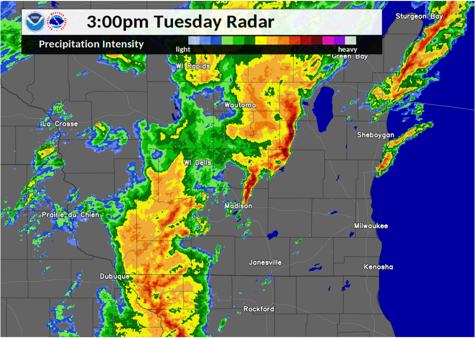
Damaging Winds Across Southeast Wisconsin A strong line of thunderstorms was tracked from western Illinois as they moved northeast. As they approached southern Wisconsin the northern portion of the storms formed into a bowing segment with very strong winds associated with it as it progressed through southern Rock and Walworth Counties. This bowing segment weakened on the north end as it pushed further northeast but the main line remain strong pushing northeast rapidly. Shortly after the first bowing segment weakened another smaller bowing segment formed in western Racine County and tracked northeast through southern Milwaukee County. Both of these bowing segments are responsible for the strongest winds with this event, however, reports of strong to severe winds occurred all along this line of storms as they tracked through southeast Wisconsin. The strongest winds from this event appear to be in the Village of Walworth/Fontane-On-Geneva areas. In addition to severe winds there was a concern for weak, short-lived tornadoes as well. With this event 2 tornado warnings were issued, one in eastern Walworth County and western Racine County and another in eastern Kenosha County. Both were issued after rotation was seen on radar with tornadic features associated with it. No tornadoes have been reported/confirmed. |
 Radar Animation |
Wind Damage
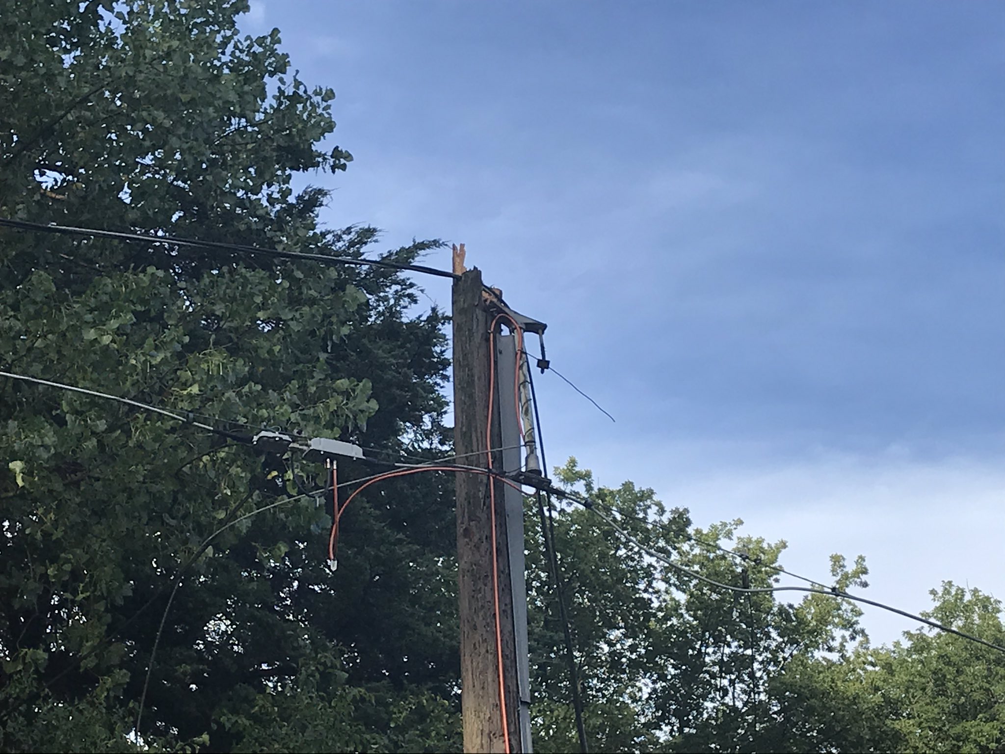
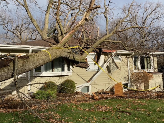
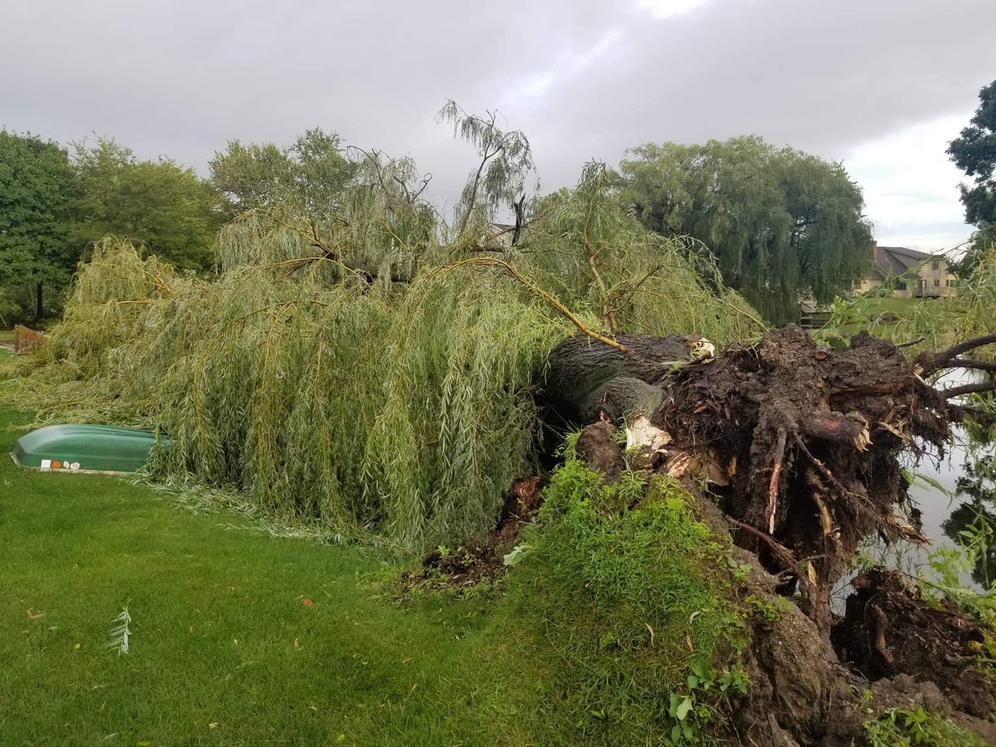
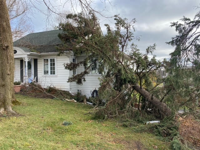
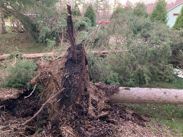
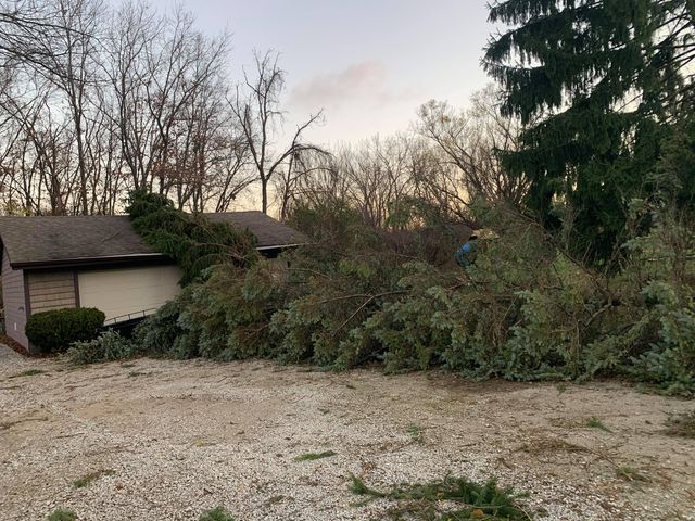
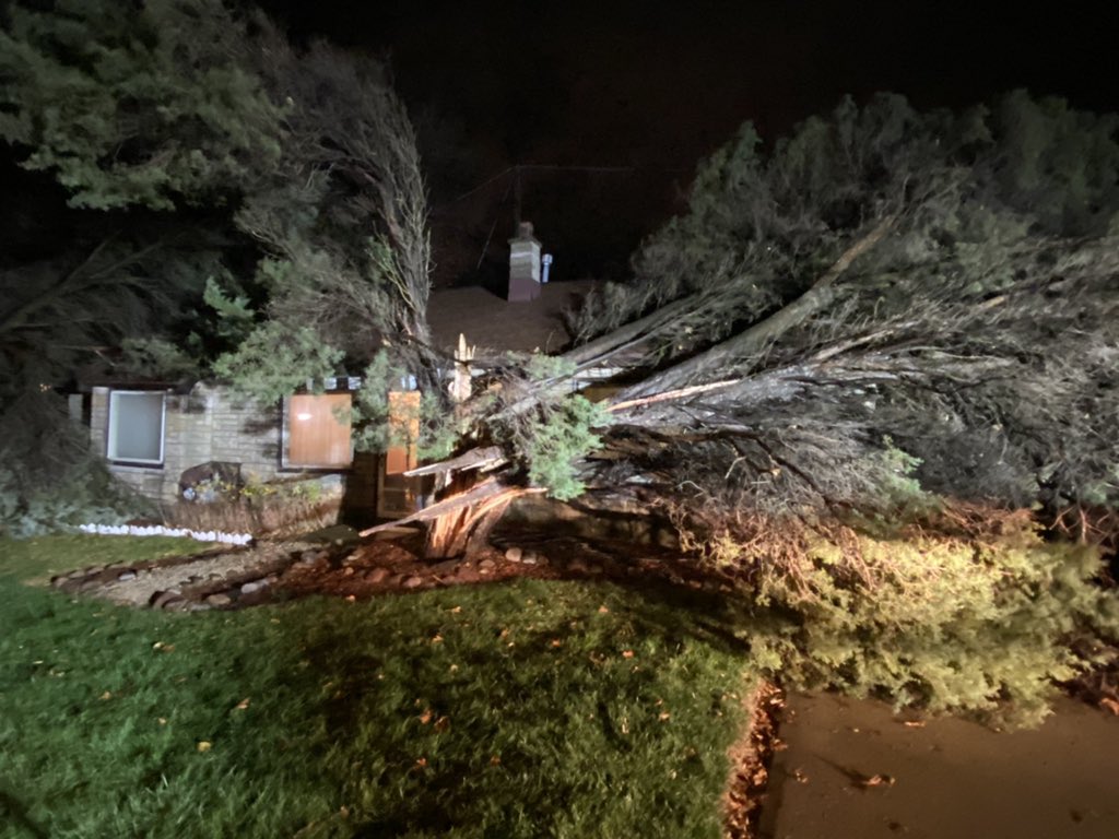
Wind damage was reported from southern Rock County to southern Waukesha County and east to Milwaukee, Racine and Kenosha Counties. It appears the most substantial damage occurred near the Village of Walworth and Fontana-On-Geneva Lake in Walworth County.
 |
|
 |
 |
|
Sharon (Courtesy Jennifer W.) |
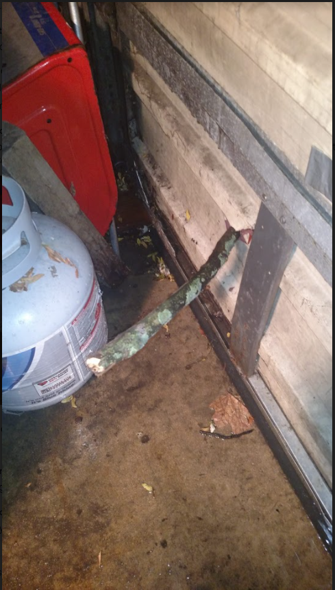
Village of Walworth (Courtesy Mati I.) |
Fontana-On-Geneva Lake (Courtesy Shanon B.) |
Fontana-On-Geneva Lake (Courtesy Local Fire Chief) |
|
|
|
 |
|
|
Fontana-On-Geneva Lake (Courtesy Local Fire Chief) |
Fontana-On-Geneva Lake (Courtesy Local Fire Chief) |
Spring Prairie (Courtesy Michael S.) |
Burlington (Courtesy WISN) |
|
|
 |
|
|
|
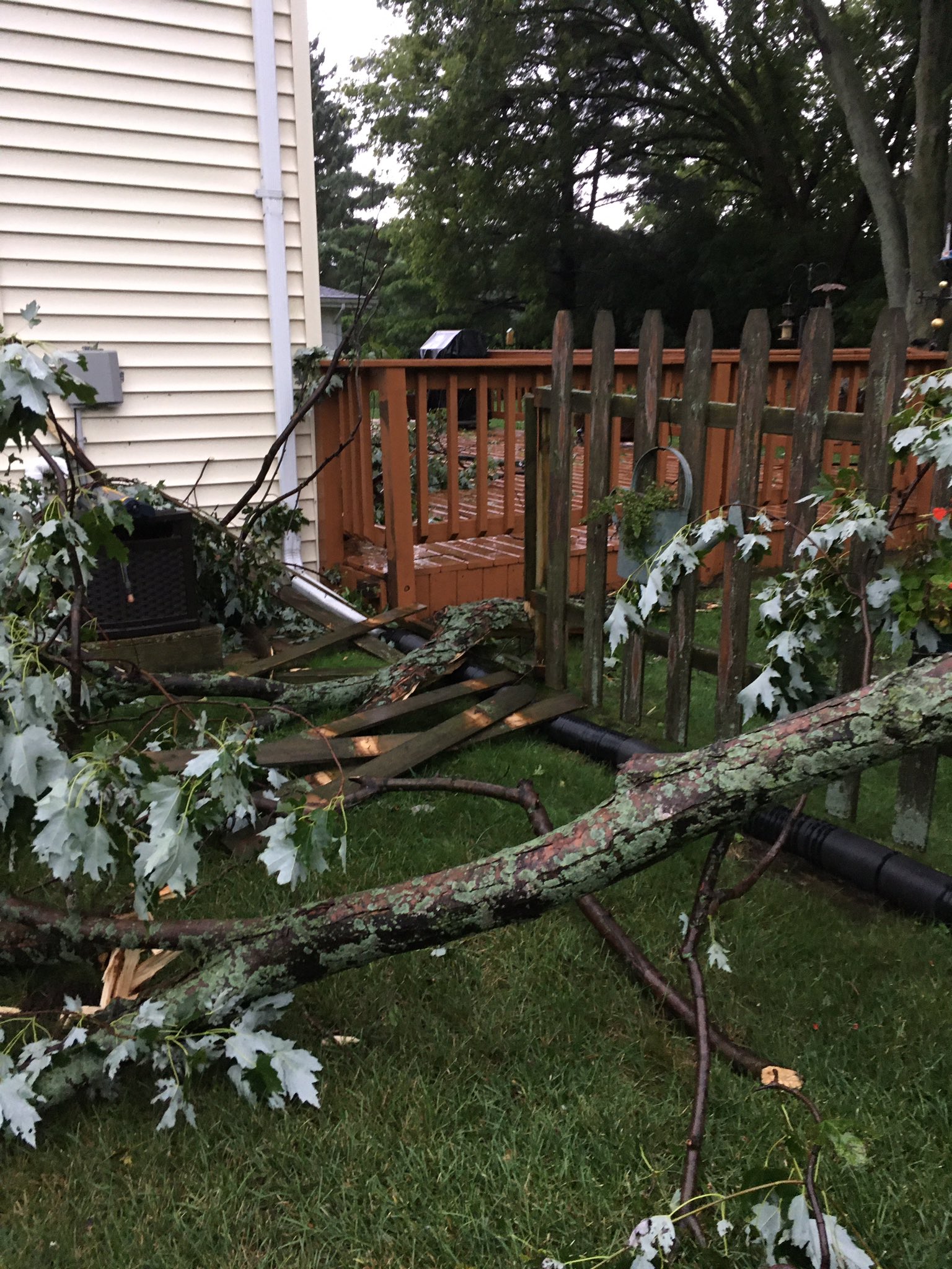
Franklin (Courtesy Rachel S. R.) |
Greendale (Courtesy Keegan K.) |
St. Francis (Courtesy Caroline R. of WISN) Bay View (Courtesy Max S.) |
Cudahy (Courtesy of N/A) |
Storm Reports
				PRELIMINARY LOCAL STORM REPORT...SUMMARY
				NATIONAL WEATHER SERVICE MILWAUKEE/SULLIVAN WI
				154 PM CST WED NOV 11 2020

				..TIME...   ...EVENT...      ...CITY LOCATION...     ...LAT.LON...
				..DATE...   ....MAG....      ..COUNTY LOCATION..ST.. ...SOURCE....
				            ..REMARKS..

				0518 PM     TSTM WND GST     3 N PLEASANT PRAIRIE    42.60N 87.94W
				11/10/2020  M60 MPH          KENOSHA            WI   ASOS

				            KENOSHA AIRPORT ASOS REPORTED GUST OF 52
				            KNOTS.

				0515 PM     TSTM WND GST     2 NW WINTHROP HARBOR    42.50N 87.85W
				11/10/2020  M64 MPH          KENOSHA            WI   PUBLIC


				0454 PM     TSTM WND GST     2 WSW SAINT FRANCIS     42.96N 87.90W
				11/10/2020  M79 MPH          MILWAUKEE          WI   ASOS

				            MITCHELL AIRPORT ASOS REPORTED 69 KNOT WIND
				            GUST.

				0509 PM     TSTM WND DMG     3 NE PLEASANT PRAIRIE   42.58N 87.88W
				11/10/2020                   KENOSHA            WI   BROADCAST MEDIA

				            LARGE TREES UPROOTED AND SNAPPED. RELAYED
				            FROM MEDIA. TIME ESTIMATED FROM RADAR.

				0503 PM     TSTM WND DMG     2 SSE WAUKESHA          42.99N 88.23W
				11/10/2020                   WAUKESHA           WI   LAW ENFORCEMENT

				            WAUKESHA COUNTY DISPATCH REPORTS MULTIPLE
				            TREES AND POWERS LINES DOWN ACROSS SOUTHERN
				            WAUKESHA.

				0455 PM     TSTM WND DMG     1 WSW SAINT FRANCIS     42.97N 87.89W
				11/10/2020                   MILWAUKEE          WI   PUBLIC

				            MULTIPLE TREES DOWN AT CORNER OF WHITNALL
				            AVE AND BOLIVAR AVE. TIME ESTIMATED FROM
				            RADAR.

				0455 PM     TSTM WND DMG     2 WNW SAINT FRANCIS     42.98N 87.91W
				11/10/2020                   MILWAUKEE          WI   PUBLIC

				            MULTIPLE TREES DOWN, INCLUDING ONE UPROOTED
				            TREE. TIME ESTIMATED FROM RADAR.

				0450 PM     TSTM WND DMG     HALES CORNERS           42.94N 88.05W
				11/10/2020                   MILWAUKEE          WI   BROADCAST MEDIA

				            A COUPLE OF TREES DOWN.

				0448 PM     TSTM WND DMG     2 ESE WAUWATOSA         43.05N 88.00W
				11/10/2020                   MILWAUKEE          WI   PUBLIC

				            MULTIPLE POWER LINES DOWN AND TRANSFORMER ON
				            FIRE. TIME ESTIMATED FROM RADAR.

				0448 PM     TSTM WND DMG     1 W SAINT FRANCIS       42.97N 87.89W
				11/10/2020                   MILWAUKEE          WI   BROADCAST MEDIA

				            REPORTS OF POWER CABLES DOWN. TIME ESTIMATED
				            FROM RADAR.

				0445 PM     TSTM WND DMG     1 NW FRANKLIN           42.90N 88.02W
				11/10/2020                   MILWAUKEE          WI   PUBLIC

				            DELAYED REPORT VIA SOCIAL MEDIA. 4 60FT PINE
				            TREES WERE UPROOTED OR SNAPPED.

				0445 PM     TSTM WND DMG     1 E GREENDALE           42.94N 87.98W
				11/10/2020                   MILWAUKEE          WI   PUBLIC


				0440 PM     TSTM WND DMG     BIG BEND                42.88N 88.20W
				11/10/2020                   WAUKESHA           WI   911 CALL CENTER

				            REPORTS OF MULTIPLE TREES DOWN AND LARGE
				            LIMBS DOWNS. TIME ESTIMATED FROM RADAR.

				0440 PM     TSTM WND DMG     5 N UNION GROVE         42.76N 88.05W
				11/10/2020                   RACINE             WI   EMERGENCY MNGR

				            DELAYED REPORT. NUMEROUS TREES, BRANCHES AND
				            LINES DOWN ACROSS RACINE COUNTY. SCATTERED
				            POWER OUTAGES ARE LINGERING THIS MORNING.

				0436 PM     TSTM WND DMG     2 SSE WAUKESHA          42.99N 88.23W
				11/10/2020                   WAUKESHA           WI   911 CALL CENTER

				            MULTIPLE TREES DOWN AND POWERS LINES SNAPPED
				            FROM VERNON TO SOUTHERN WAUKESHA CITY. TIME
				            ESTIMATED FROM RADAR.

				0433 PM     TSTM WND DMG     ROCHESTER               42.74N 88.22W
				11/10/2020                   RACINE             WI   911 CALL CENTER

				            MULTIPLE REPORTS OF TREES ON ROADWAYS AND
				            POWER POLES SNAPPED. TIME ESTIMATED FROM
				            RADAR.

				0430 PM     TSTM WND DMG     1 WSW BURLINGTON        42.67N 88.29W
				11/10/2020                   RACINE             WI   BROADCAST MEDIA

				            MULTIPLE TREES DOWN AT STATE STREET AND
				            OAKLAND AVENUE. TIME ESTIMATED FROM RADAR.

				0429 PM     TSTM WND DMG     GENOA CITY              42.50N 88.32W
				11/10/2020                   WALWORTH           WI   PUBLIC

				            TREE DOWN ON ON A HOUSE, KNOCKING OUT
				            POWERLINES IN THE PROCESS. RELAYED FROM
				            SOCIAL MEDIA. TIME ESTIMATED FROM RADAR.

				0427 PM     TSTM WND DMG     1 NE WALWORTH           42.55N 88.59W
				11/10/2020                   WALWORTH           WI   PUBLIC

				            REPORT FROM MPING: TREES UPROOTED OR
				            SNAPPED; ROOF BLOWN OFF.

				0425 PM     TSTM WND DMG     7 W BURLINGTON          42.69N 88.41W
				11/10/2020                   WALWORTH           WI   PUBLIC

				            DELAYED REPORT: MULTIPLE LARGE TREES SNAPPED
				            IN SPRING PRAIRIE. TIME ESTIMATED BASED ON
				            RADAR.

				0422 PM     TSTM WND DMG     1 SW DELAFIELD          43.06N 88.41W
				11/10/2020                   WAUKESHA           WI   PUBLIC

				            REPORTS OF MULTIPLE POWER LINES
				            DOWN/SNAPPED. TIME ESTIMATED FROM RADAR.

				0421 PM     TSTM WND DMG     4 NNE LAKE GENEVA       42.64N 88.41W
				11/10/2020                   WALWORTH           WI   911 CALL CENTER

				            REPORT OF MULTIPLE TREES DOWN AND A TREE ON
				            A HOUSE IN SPRINGFIELD. TIME ESTIMATED FROM
				            RADAR.

				0418 PM     TSTM WND DMG     FONTANA-ON-GENEVA       42.55N 88.56W
				11/10/2020                   WALWORTH           WI   PUBLIC

				            ROOF BLOWN OFF A HOUSE AND MULTIPLE TREES
				            DOWN. RELAYED FROM SOCIAL MEDIA. TIME
				            ESTIMATED FROM RADAR.

				0415 PM     TSTM WND DMG     FONTANA-ON-GENEVA       42.55N 88.57W
				11/10/2020                   WALWORTH           WI   PUBLIC

				            MULTIPLE TREES DOWN. RELAYED FROM SOCIAL
				            MEDIA.

				0412 PM     TSTM WND DMG     FONTANA-ON-GENEVA       42.55N 88.57W
				11/10/2020                   WALWORTH           WI   FIRE DEPT/RESCUE

				            DELAYED REPORT. 9 LARGE TREES FELL ON HOMES.
				            MANY OTHER VERY LARGE TREES FELL WERE
				            UPROOTED OR SNAPPED IN THE FONTANA AREA.

				0410 PM     TSTM WND DMG     4 ENE JANESVILLE        42.70N 88.93W
				11/10/2020                   ROCK               WI   PUBLIC

				            ROOF BLOWN OFF A BARN.

				0406 PM     TSTM WND DMG     BELOIT                  42.53N 89.02W
				11/10/2020                   ROCK               WI   LAW ENFORCEMENT

				            WIDE SPREAD TREE DAMAGE REPORTED BY ROCK
				            COUNTY DISPATCH FROM BELOIT TO JANESVILLE.

				0401 PM     TSTM WND DMG     3 E JANESVILLE          42.69N 88.95W
				11/10/2020                   ROCK               WI   911 CALL CENTER

				            PORTIONS OF HIGHWAY 14 CLOSED DUE TO POWER
				            POLES ON ROADWAY. TIME ESTIMATED FROM RADAR.
 |
Media use of NWS Web News Stories is encouraged! Please acknowledge the NWS as the source of any news information accessed from this site. |
|