Widespread life-threatening flash and urban flooding continues in south-central Texas, with considerable flooding impacts possible across central Texas. Wildfire smoke is impacting air quality across much of the Great Lakes region into southern New England and the Mid-Atlantic. Monsoonal thunderstorms may produce isolated to scattered flash flooding across the Southwest into the Great Basin. Read More >
Milwaukee/Sullivan, WI
Weather Forecast Office
Overview
|
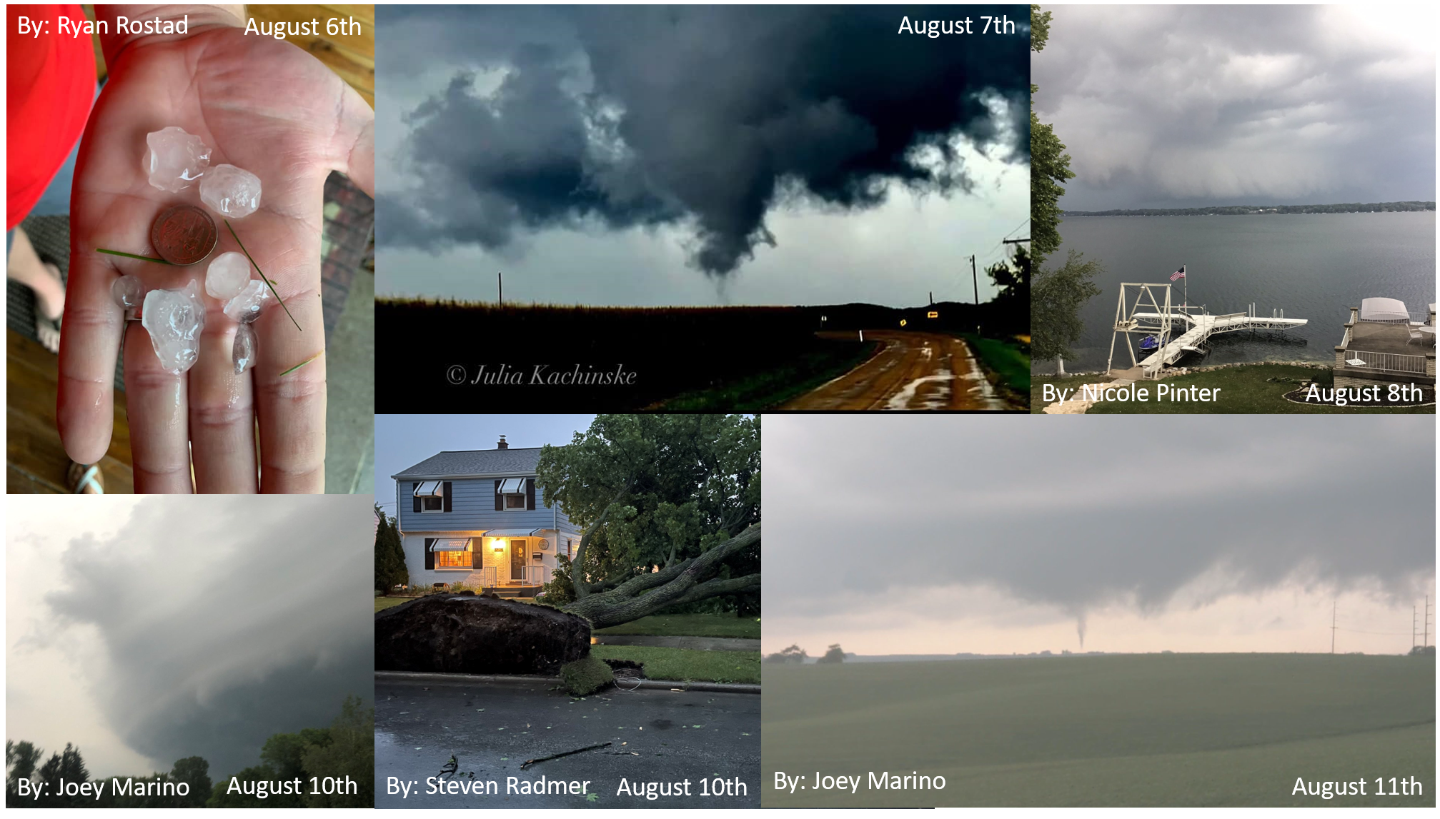
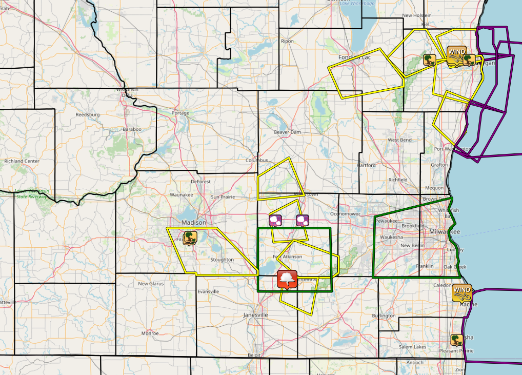
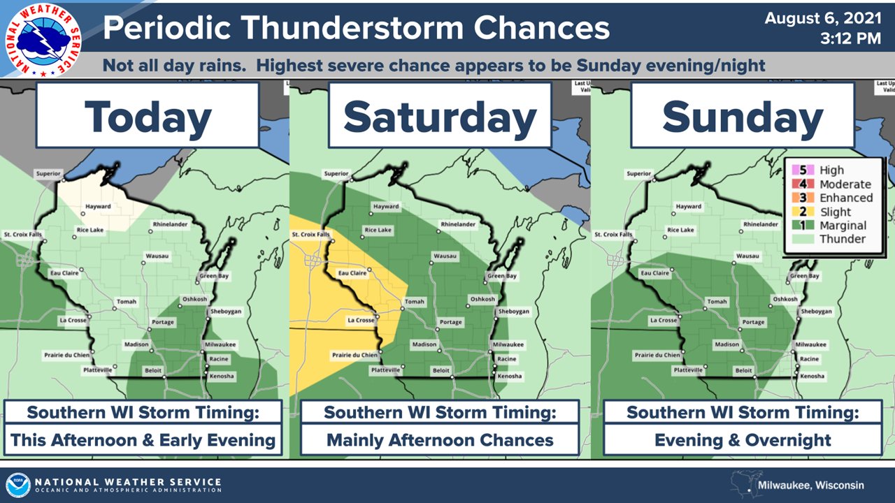
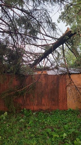
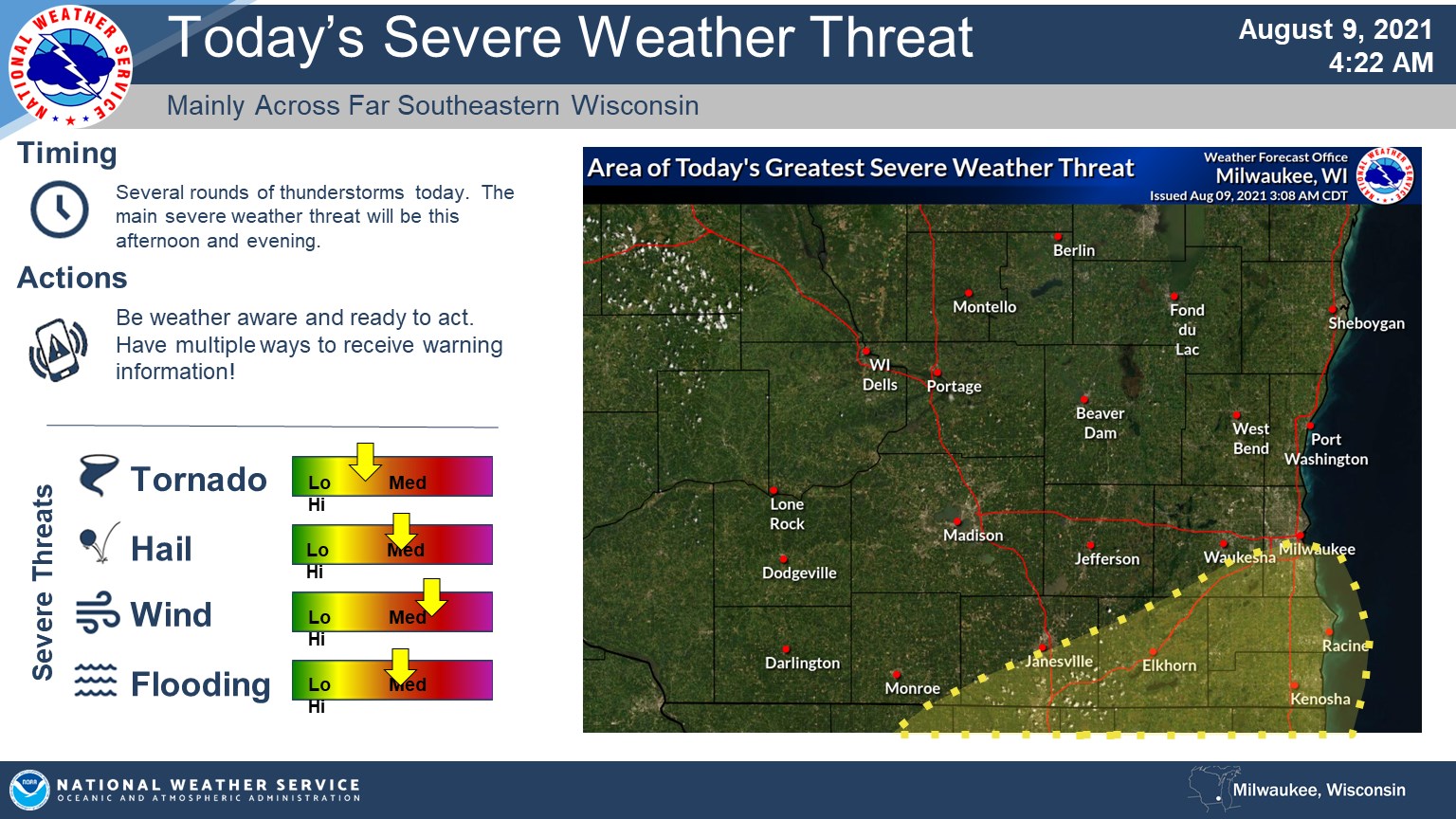
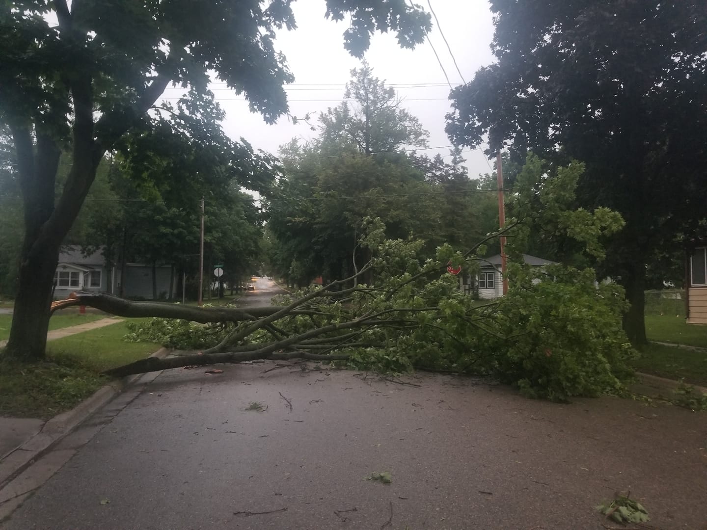
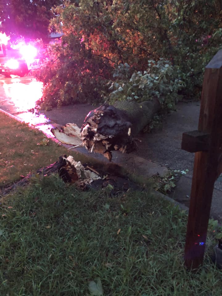
A very busy six day period occurred to start the month of August across much of Wisconsin. Multiple days of strong to severe storms resulted in hail, damaging winds that knocked down trees and powerlines, as well as a few tornadoes. The biggest severe weather day and most widespread damage occurred on August 10th, 2021. Near record instability present across southern Wisconsin resulted in a line of thunderstorms that moved from west to east and produced persistent wind gusts of 40 to 60 mph for upwards of 20 minutes. A stronger core of winds was noted from east of Janesville to southern Waukesha, to New Berlin, and then into West Allis. In particular a gust of 77 mph was recorded in Eagle in Waukesha County. Hundreds of thousands of customers across southern Wisconsin were without power and it took multiple days to restore power to all of the impacted customers. We-Energies stated this was likely the largest outage in the companies history and the largest restoration effort they have ever embarked on.
In addition to the strong to severe storms this stretch of active weather brought some much needed rainfall to ease the ongoing drought conditions. Much of southern Wisconsin entering the month of August was between 9 to 10 inches below normal for rainfall for the year. While some locations were able to receive upwards of 8 to 9 inches of rainfall this was not widespread. On average much of Wisconsin received between 2 to 3 inches of rainfall. While that did help portions of southern Wisconsin along the Wisconsin and Illinois border remain in severe drought. |
 Insert Picture of Thunderstorm Shelf Cloud or Tornado from this week. |
Overview
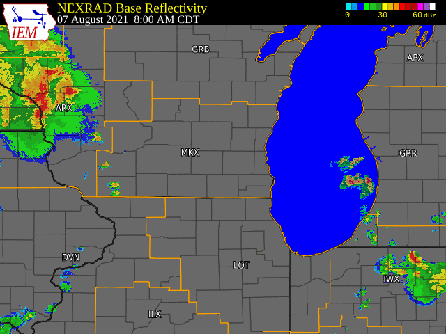
Storms started by early afternoon across southeastern Wisconsin from Madison northeast into Sheboygan. Strong wind gusts of 63 mph were reported in Sheboygan with some tree damage. Storms continued to slowly move south to southeast with very few additional reports of damage. It wasn't until later into the evening did additional hail and damaging wind reports occur. A few spotters reported some brief funnel clouds west of Whitewater in Rock County but no damage or tornadoes were reported from these reports. Main thing that came with this round of storms was some beneficial rainfall.
Radar:
Storms developed across central Wisconsin and eventually morphed into a line that dropped south into Illinois. Persistent easterly winds helped to keep some storms going across far southern Wisconsin through the late evening hours.
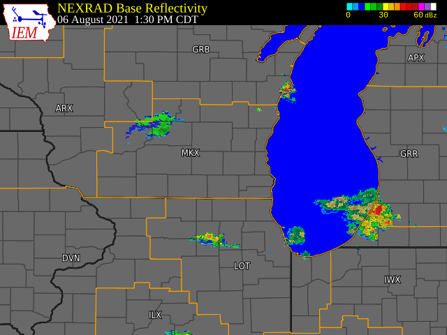 |
| Radar loop with warnings issued by NWS Offices for Friday August 6th. |
Photos:
 |
 |
 |
 |
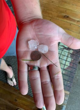
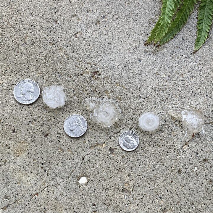
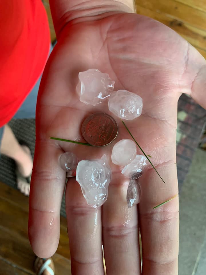
| One Inch Hail in Lake Mills | Hail in Columbus | Quarter size hail Cambridge | Quarter size hail in Columbus |
 |
 |
 |
 |
| Quarter size hail Colubmus | Quarter size hail Colubmus | Near golf ball size hail Johnson Creek | Quarter size hail in Hartford |
Storm Reports
Header
 |
 |
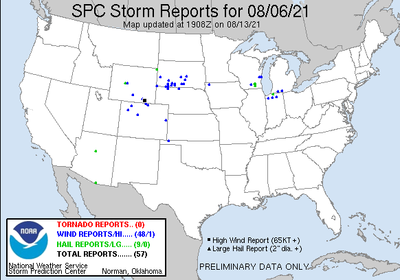
| SPC Storm Reports for Aug. 6th 2021 | Link to Map of storm reports |
								PRELIMINARY LOCAL STORM REPORT...SUMMARY
								NATIONAL WEATHER SERVICE MILWAUKEE/SULLIVAN WI
								550 PM CDT SUN AUG 15 2021

								..TIME...   ...EVENT...      ...CITY LOCATION...     ...LAT.LON...
								..DATE...   ....MAG....      ..COUNTY LOCATION..ST.. ...SOURCE....
								            ..REMARKS..

								0428 PM     TSTM WND GST     3 NNW SHEBOYGAN FALLS   43.77N 87.85W
								08/06/2021  M63 MPH          SHEBOYGAN          WI   ASOS

								            MEASURED AT THE ASOS AT SHEBOYGAN COUNTY
								            MEMORIAL AIRPORT.

								0428 PM     TSTM WND GST     3 SSW HOWARDS GROVE     43.78N 87.85W
								08/06/2021  M63 MPH          SHEBOYGAN          WI   ASOS

								            ASOS STATION KSBM SHEBOYGAN-AIRPORT.

								0445 PM     TSTM WND DMG     2 WNW PLYMOUTH          43.76N 88.01W
								08/06/2021                   SHEBOYGAN          WI   BROADCAST MEDIA

								            RELAYED REPORT OF TREE DAMAGE IN PLYMOUTH.
								            TIME ESTIMATED.

								0458 PM     TSTM WND DMG     2 N KOHLER              43.76N 87.78W
								08/06/2021                   SHEBOYGAN          WI   PUBLIC

								            3 INCH TREE LIMBS REPORTED BROKEN. RECEIVED
								            VIA MPING.

								0615 PM     HAIL             LAKE MILLS              43.08N 88.91W
								08/06/2021  E1.50 INCH       JEFFERSON          WI   PUBLIC

								            1-1.5 INCH HAIL. REPORTED VIA SOCIAL MEDIA.
								            TIME ESTIMATED FROM RADAR.

								0632 PM     HAIL             1 ESE JOHNSON CREEK     43.08N 88.75W
								08/06/2021  E1.50 INCH       JEFFERSON          WI   PUBLIC

								            1 TO 1.5 HAIL. PICTURE VIA SOCIAL MEDIA.

								0704 PM     HEAVY RAIN       1 SW MEQUON             43.22N 88.00W
								08/06/2021  M1.20 INCH       OZAUKEE            WI   PUBLIC


								0741 PM     NON-TSTM WND GST 2 W NORTH BAY           42.77N 87.82W
								08/06/2021  M49 MPH          RACINE             WI   ASOS

								            ASOS STATION KRAC RACINE-BATTEN AIRPORT.

								0808 PM     HAIL             5 W WHITEWATER          42.83N 88.84W
								08/06/2021  E1.00 INCH       ROCK               WI   PUBLIC

								            REPORT JUST OUTSIDE OF WHITEWATER ALONG
								            COUNTY ROAD N OF QUARTER SIZE HAIL.

								0828 PM     FUNNEL CLOUD     5 W WHITEWATER          42.83N 88.84W
								08/06/2021                   ROCK               WI   TRAINED SPOTTER

								            SPOTTER REPORTS FUNNEL CLOUD EXTENDING ABOUT
								            HALF WAY DOWN.

								0830 PM     TSTM WND DMG     2 WSW KENOSHA           42.57N 87.85W
								08/06/2021                   KENOSHA            WI   BROADCAST MEDIA

								            TREE DOWN ON A HOUSE RELAYED FROM BROADCAST
								            MEDIA. TIME ESTIMATED.

								0842 PM     HEAVY RAIN       1 NW WAUKESHA           43.03N 88.25W
								08/06/2021  M2.38 INCH       WAUKESHA           WI   PUBLIC


								0955 PM     TSTM WND DMG     2 NE FITCHBURG          43.01N 89.40W
								08/06/2021                   DANE               WI   BROADCAST MEDIA

								            CORRECTS PREVIOUS TSTM WND DMG REPORT FROM 2
								            NE FITCHBURG.... SEVERAL LARGE TREE LIMBS
								            REPORTED DOWN. TIME ESTIMATED FROM RADAR.

								1000 PM     TSTM WND DMG     1 NNE FITCHBURG         43.00N 89.41W
								08/06/2021                   DANE               WI   BROADCAST MEDIA

								            MEDIUM TREE BRANCHES DOWN IN FITCHBURG. TIME
								            ESTIMATED.

								0700 AM     HEAVY RAIN       1 W OCONOMOWOC          43.11N 88.52W
								08/07/2021  M2.26 INCH       WAUKESHA           WI   COCORAHS


								0700 AM     HEAVY RAIN       1 ENE GREENDALE         42.94N 87.98W
								08/07/2021  E2.03 INCH       MILWAUKEE          WI   COCORAHS


								0700 AM     HEAVY RAIN       1 NNW BELGIUM           43.51N 87.86W
								08/07/2021  M2.03 INCH       OZAUKEE            WI   CO-OP OBSERVER


								0700 AM     HEAVY RAIN       1 SE OCONOMOWOC         43.10N 88.49W
								08/07/2021  M2.42 INCH       WAUKESHA           WI   CO-OP OBSERVER

								            RETIRED NWS EMPLOYEE.

								0700 AM     HEAVY RAIN       4 E BEAVER DAM          43.46N 88.76W
								08/07/2021  M2.27 INCH       DODGE              WI   COCORAHS


								0700 AM     HEAVY RAIN       4 NE VERONA             43.02N 89.48W
								08/07/2021  M2.07 INCH       DANE               WI   COCORAHS


								0700 AM     HEAVY RAIN       4 NE OREGON             42.97N 89.34W
								08/07/2021  M2.10 INCH       DANE               WI   PUBLIC


								0700 AM     HEAVY RAIN       3 N KEKOSKEE            43.57N 88.57W
								08/07/2021  M2.11 INCH       DODGE              WI   COCORAHS


								&&

								$$
Environment:
 |
 |
 |
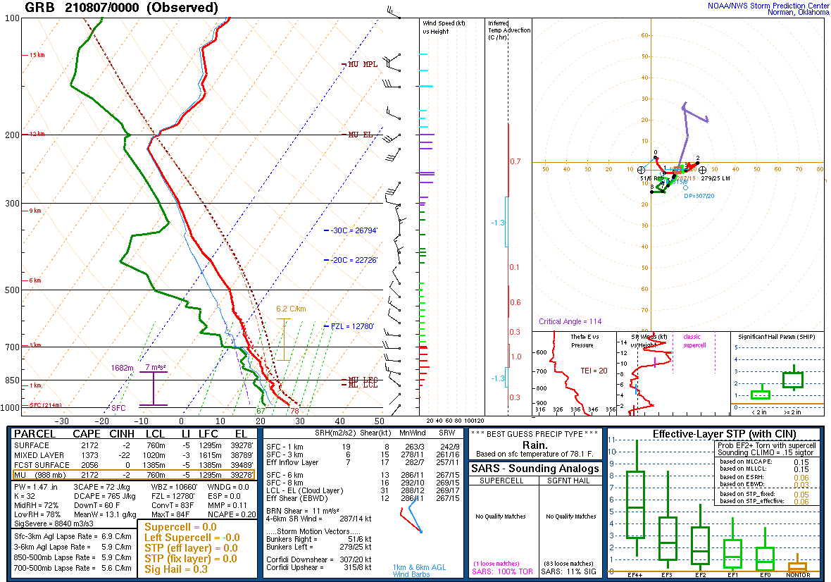 |
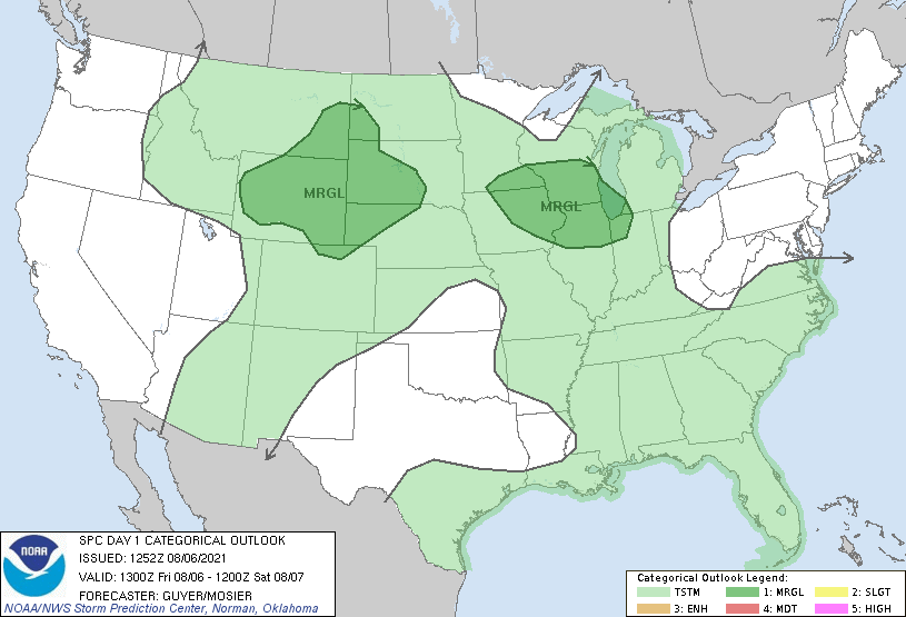
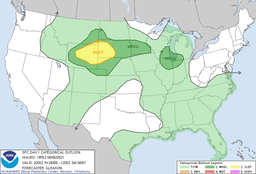
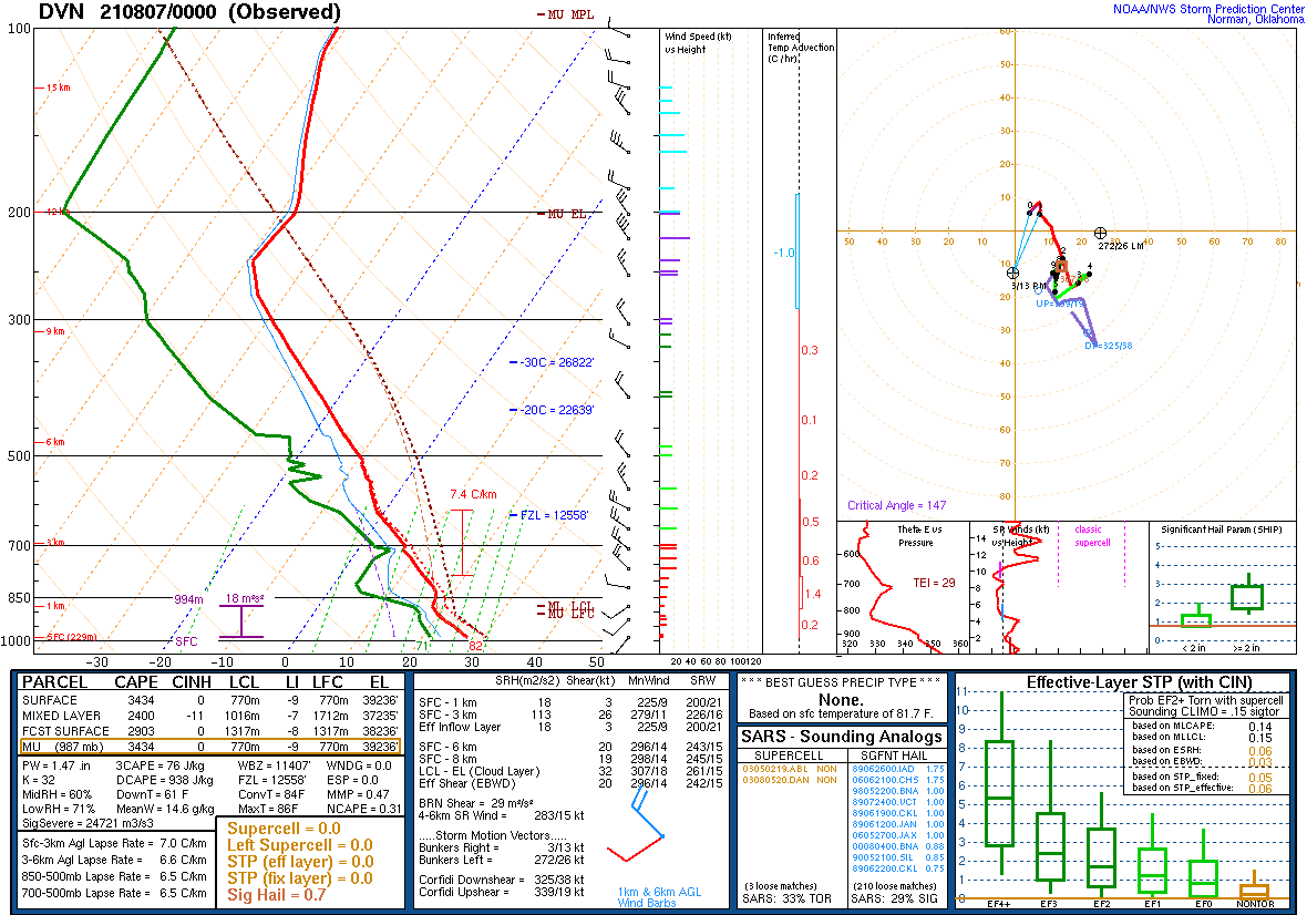
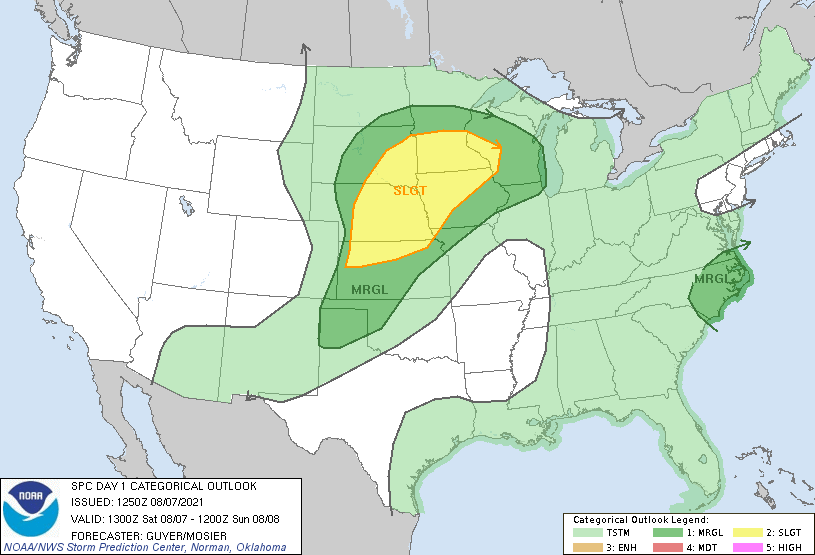
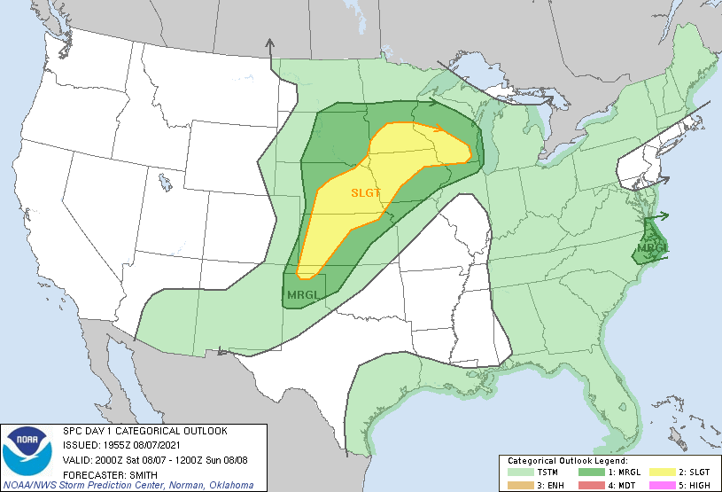
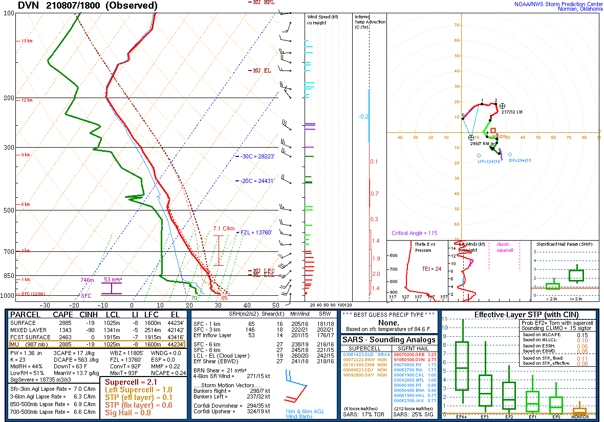
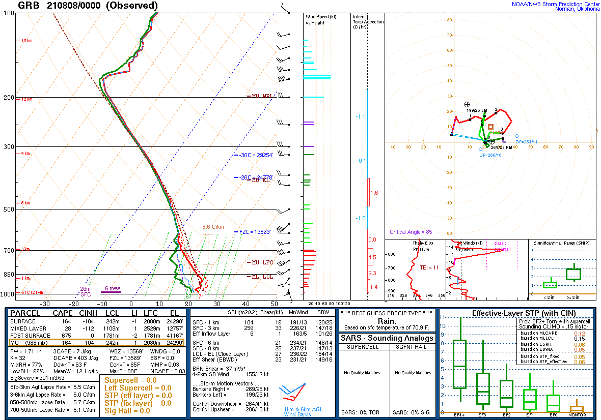
| SPC Day 1 Outlook 13 UTC | SPC Day 1 Outlook 20 UTC | DVN Sounding Friday Evening | GRB Sounding Friday Evening |
Messaging:
 |
| NWS Milwaukee discussing the busy days ahead with multiple chances for severe weather through the weekend. |
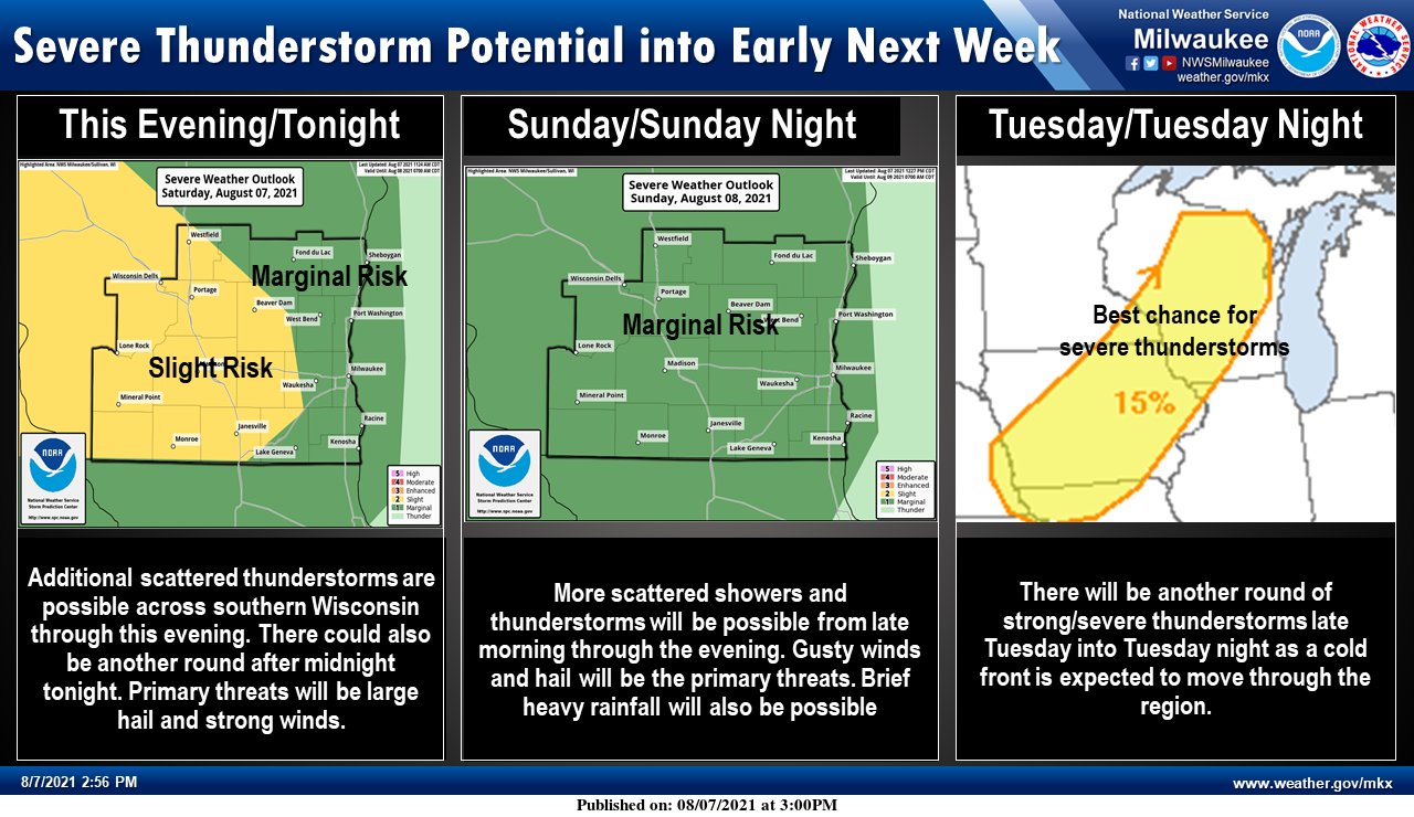
Overview
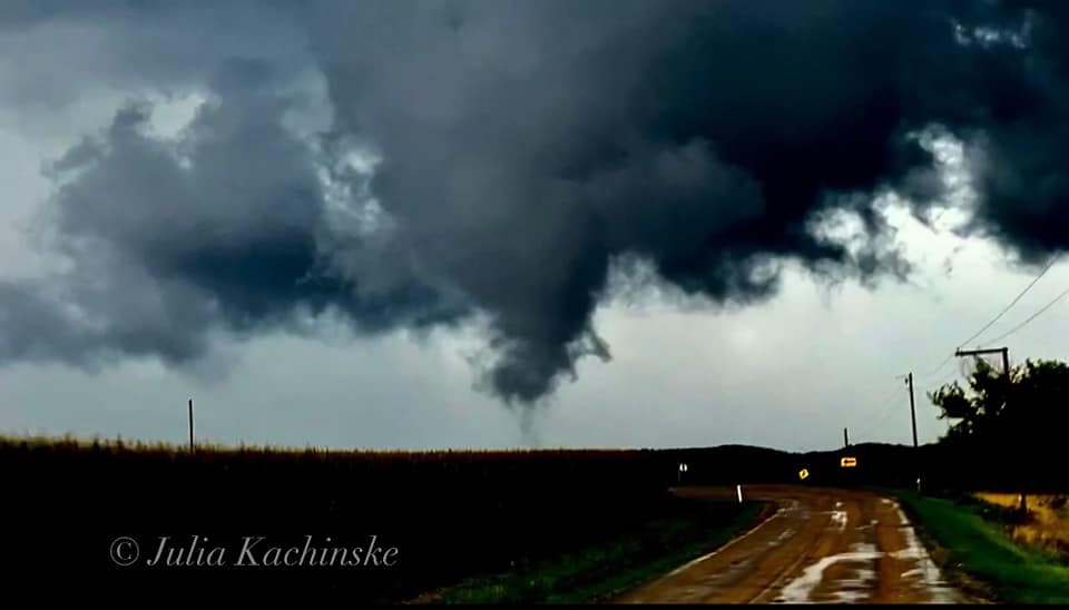
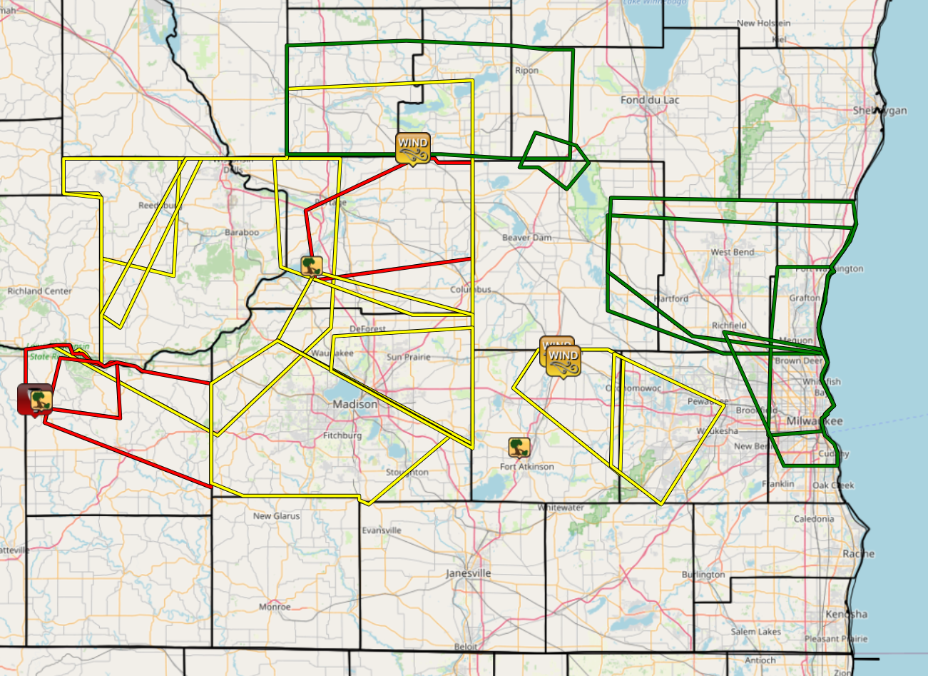
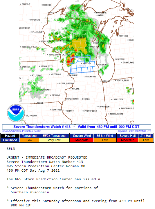
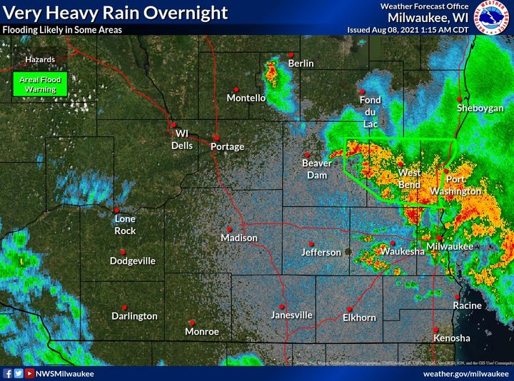
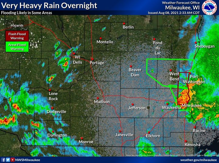
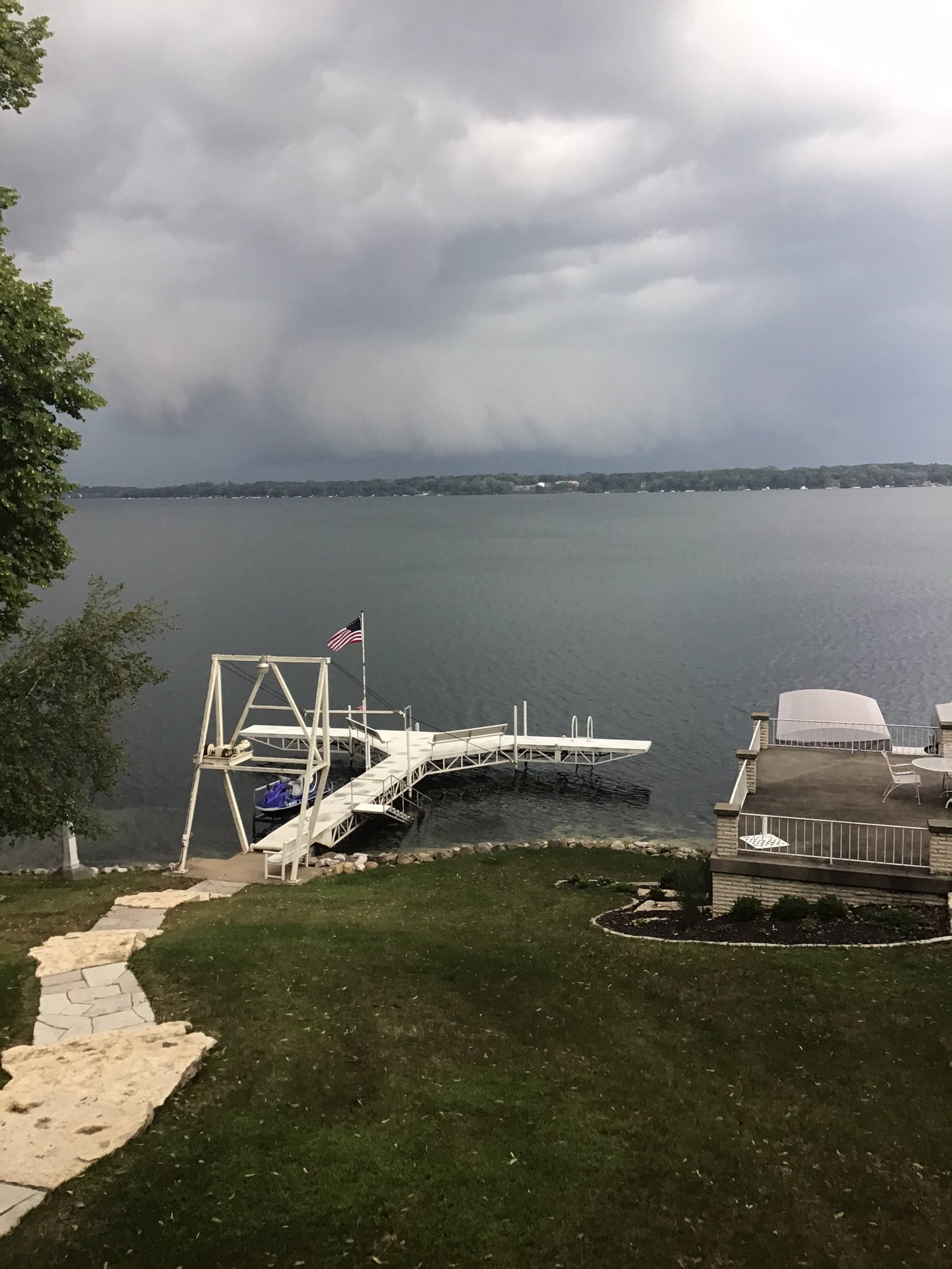
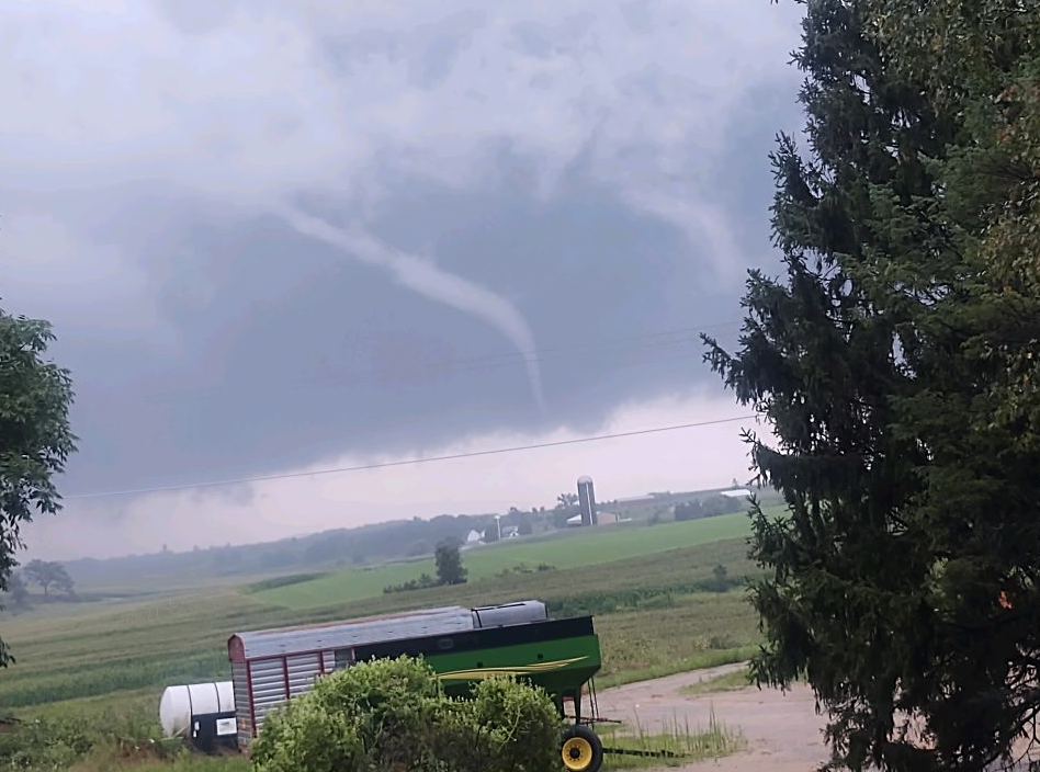
Multiple rounds of thunderstorms were observed on Saturday August 7th. The morning round was a decaying Mesoscale-Convective-System (MCS) that had developed over Minnesota earlier and was moving southeast into southern Wisconsin. A few stronger wind gust were observed with these storms. Then a warm front lifted north across southern Wisconsin into central Wisconsin. With much of the area now solidly in the warm sector additional storms began to develop over western and southwestern Wisconsin Saturday afternoon. A few supercells developed to the west and ended up producing an EF-1 tornado in Iowa County. The storms eventually morphed into a complex of storms that continued east and a few additional reports of damage were observed. By the overnight period storms began to back build along the Lake Michigan shoreline and heavy rainfall and minor to moderate flooding was observed in Milwaukee, Washington, and Ozaukee counties.
Tornado:
|
Tornado - Highland
|
||||||||||||||||
The Enhanced Fujita (EF) Scale classifies tornadoes into the following categories:
| EF0 Weak 65-85 mph |
EF1 Moderate 86-110 mph |
EF2 Significant 111-135 mph |
EF3 Severe 136-165 mph |
EF4 Extreme 166-200 mph |
EF5 Catastrophic 200+ mph |
 |
|||||
Radar:
A few supercell thunderstorms developed over western Wisconsin and move east into southern Wisconsin. These eventually morphed into more of a thunderstorm complex as they entered southern Wisconsin. One tornado was observed with these storms along with other wind damage and flooding along the Lake Michigan shoreline.
 |
| Radar loop with warnings issued by NWS Offices for Saturday August 7th. |
Photos:
 |
 |
 |
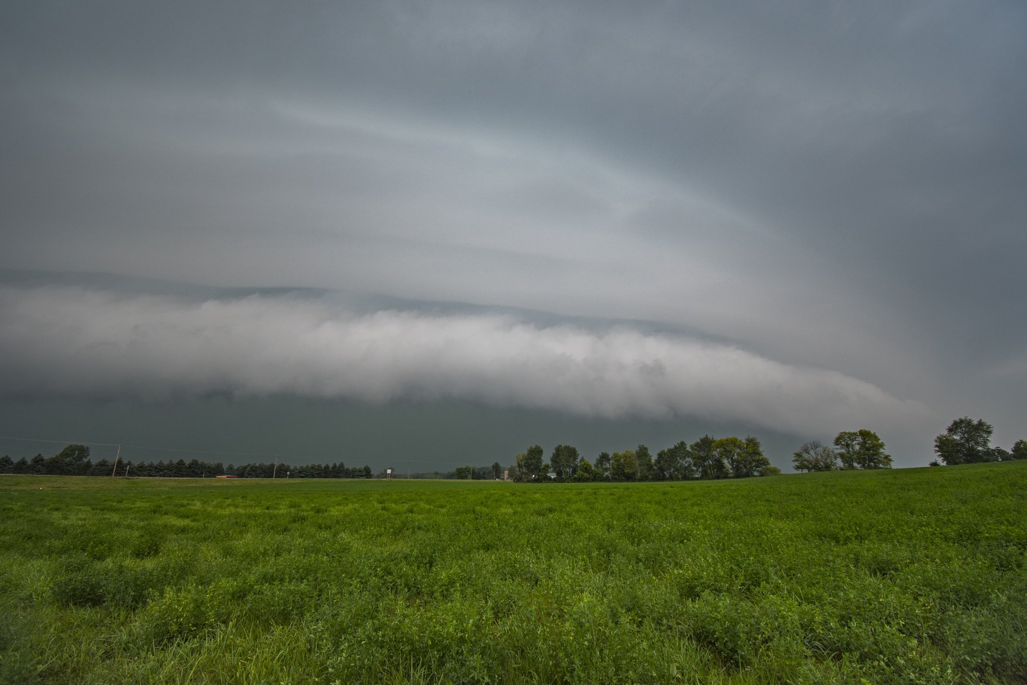 |
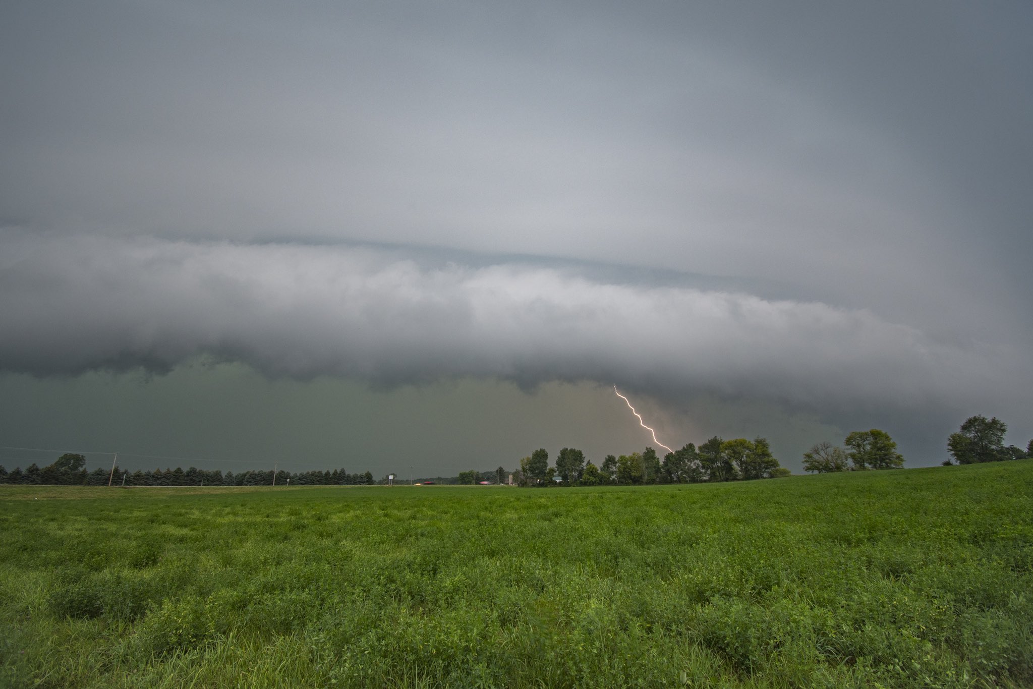
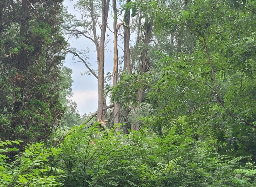
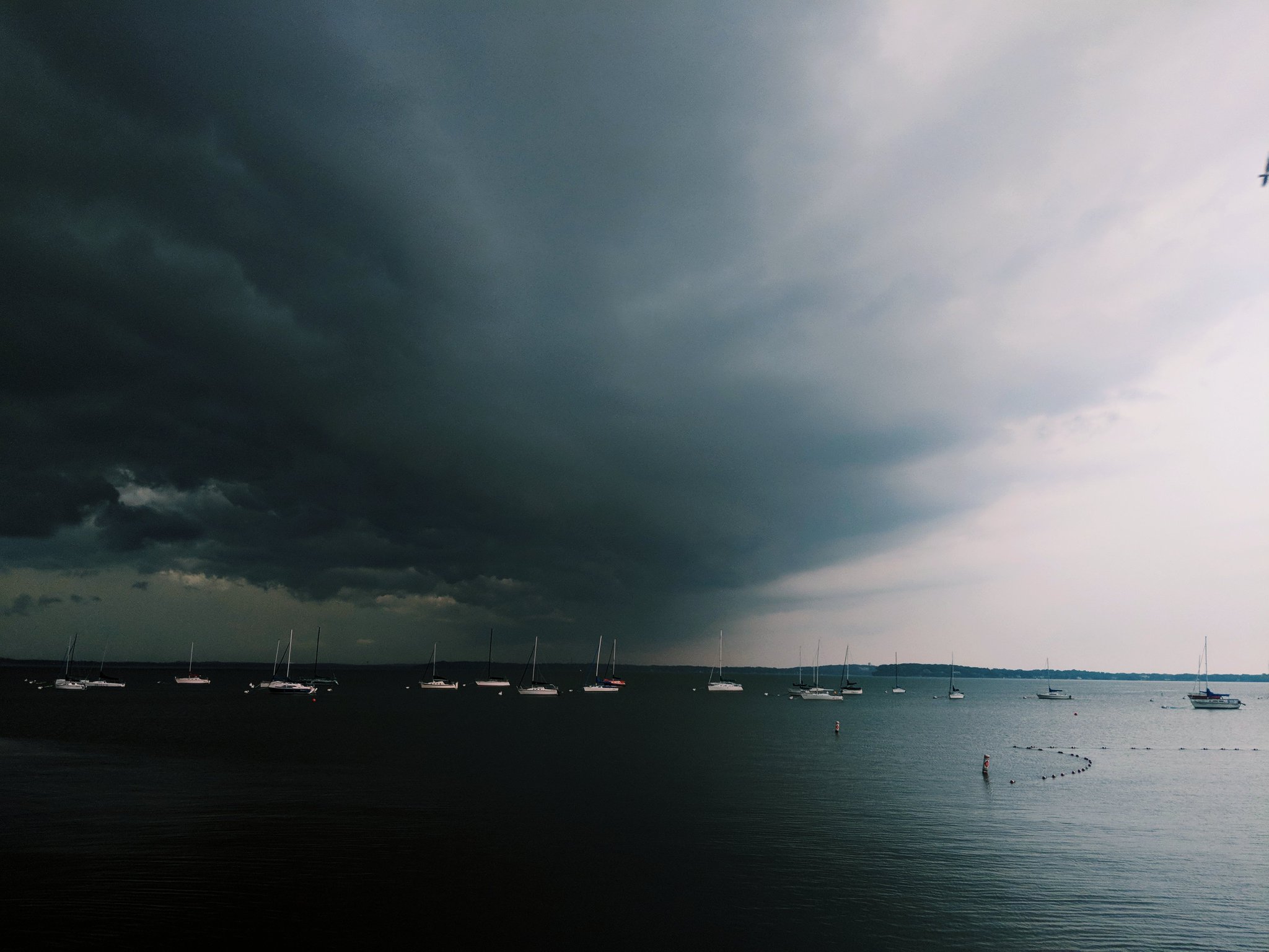
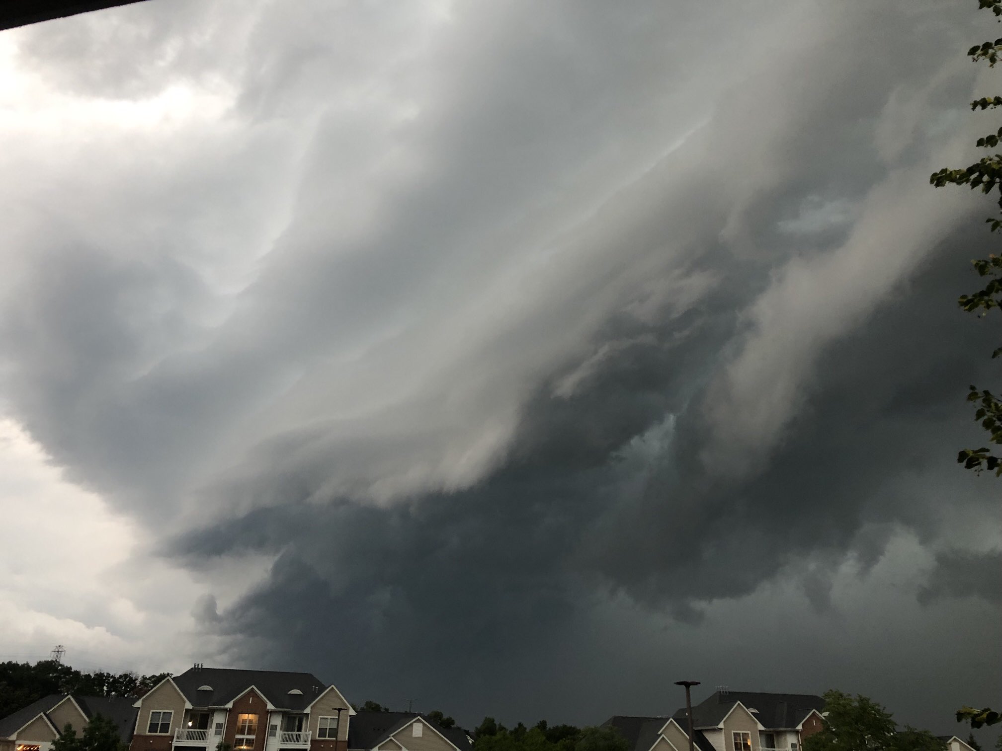
| Highland Tornado photo from Julia Kachinske | Tree damage in Watertown from @ckaniewki on Twitter | Tree damage in Dodgeville from Matthew Nevers | Shelf Cloud captured by Charlie Boudo |
 |
 |
 |
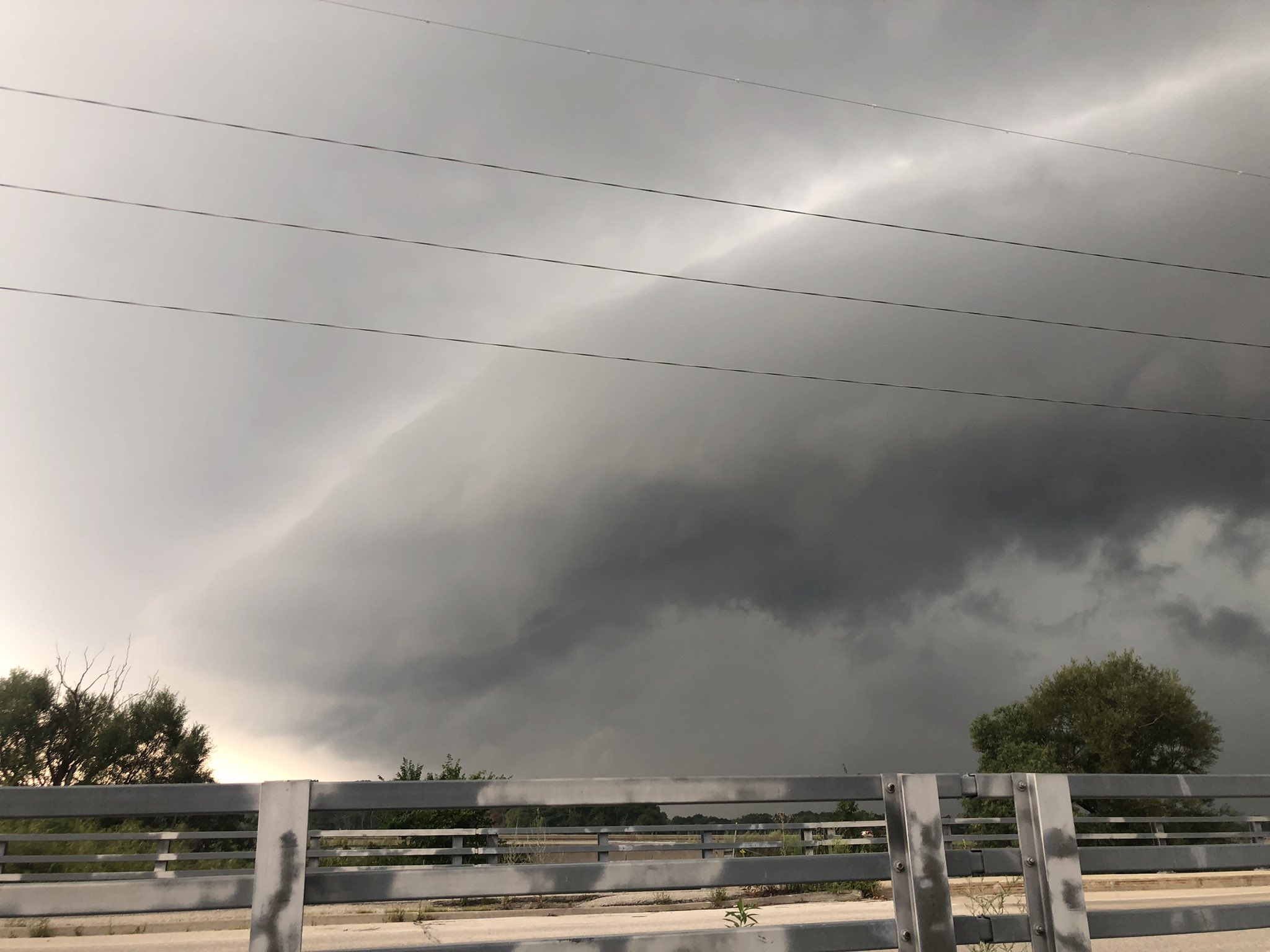 |
| Inflow into storm near Brighton | Shelf Cloud captured by Kory Hartman near Baraboo | Shelf Cloud captured by Charlie Boudo near Summit | Shelf Cloud captured by Charlie Boudo |
Storm Reports
Header
 |
 |
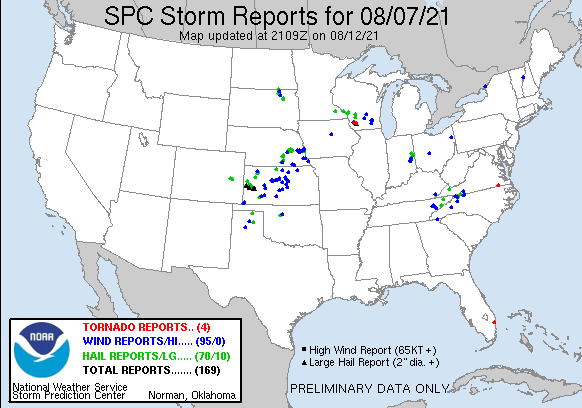
| SPC Storm Reports for Aug. 7th 2021 | Link to Map of storm reports |
								PRELIMINARY LOCAL STORM REPORT...SUMMARY
								NATIONAL WEATHER SERVICE MILWAUKEE/SULLIVAN WI
								710 PM CDT SUN AUG 15 2021

								..TIME...   ...EVENT...      ...CITY LOCATION...     ...LAT.LON...
								..DATE...   ....MAG....      ..COUNTY LOCATION..ST.. ...SOURCE....
								            ..REMARKS..

								1230 PM     TSTM WND DMG     1 W WATERTOWN           43.19N 88.74W
								08/07/2021                   JEFFERSON          WI   NWS EMPLOYEE

								            LARGE TREES DOWN ALONG WEST ST. ALONG WITH
								            PEA SIZE HAIL.

								1230 PM     TSTM WND GST     1 W WATERTOWN           43.19N 88.74W
								08/07/2021  E60 MPH          JEFFERSON          WI   NWS EMPLOYEE


								1235 PM     TSTM WND GST     1 S WATERTOWN           43.17N 88.72W
								08/07/2021  M60 MPH          JEFFERSON          WI   AWOS

								            MEASURED AT WATERTOWN AIRPORT.

								1235 PM     TSTM WND DMG     1 S WATERTOWN           43.17N 88.72W
								08/07/2021                   JEFFERSON          WI   PUBLIC

								            TREE DOWN ALONG BOOMER ST.

								0509 PM     TORNADO          2 NNW HIGHLAND          43.08N 90.40W
								08/07/2021                   IOWA               WI   NWS STORM SURVEY

								            NWS DAMAGE SURVEY IN NW IOWA COUNTY FOUND
								            LOW END EF-1 TORNADO DAMAGE. MAIN STRUCTURAL
								            DAMAGE TO TWO BARNS ON A PROPERTY NORTH OF
								            HIGHLAND ON CAMP RD. OTHERWISE, MAINLY
								            SPORADIC TREE DAMAGE EAST OF THERE.

								0509 PM     HAIL             3 NNW HIGHLAND          43.08N 90.39W
								08/07/2021  M2.50 INCH       IOWA               WI   PUBLIC

								            MULTIPLE REPORTS OF TENNIS BALL SIZED HAIL
								            FROM FARMERS IN NW IOWA COUNTY VIA NWS
								            DAMAGE SURVEY. NO MEASUREMENTS, BUT SAID TWO
								            HAIL STONES WOULD FIT END TO END ON A DOLLAR
								            BILL OR SLIGHTLY LOWER.

								0513 PM     TSTM WND DMG     3 ENE LAKE WISCONSIN    43.39N 89.52W
								08/07/2021                   COLUMBIA           WI   LAW ENFORCEMENT

								            LARGE TREE LIMB DOWN ON POWER LINE OFF OF
								            COUNTY HIGHWAY V.

								0515 PM     TSTM WND DMG     2 N HIGHLAND            43.08N 90.38W
								08/07/2021                   IOWA               WI   LAW ENFORCEMENT

								            COUNTY SHERIFF REPORTS BARN DAMAGE AND TREES
								            TOPPED ALONG CAMP ROAD NORTH OF HIGHLAND.
								            POSSIBLE TORNADO.

								0550 PM     TSTM WND GST     4 SW KINGSTON           43.66N 89.20W
								08/07/2021  E50 MPH          GREEN LAKE         WI   EMERGENCY MNGR

								            CORRECTS PREVIOUS TSTM WND GST REPORT FROM 4
								            SW KINGSTON. DALTON.

								0730 PM     TSTM WND DMG     3 NNW FORT ATKINSON     42.97N 88.86W
								08/07/2021                   JEFFERSON          WI   PUBLIC

								            TREES AND LIMBS DOWN ALONG KIESLING RD.

								0117 AM     FLOOD            GRAFTON                 43.32N 87.95W
								08/08/2021                   OZAUKEE            WI   TRAINED SPOTTER

								            REPORT OF ONE FOOT OR MORE OF WATER OVER
								            GREEN BAY RD. JUST SOUTH OF FALLS ROAD IN
								            GRAFTON.

								0127 AM     FLOOD            MEQUON                  43.23N 87.98W
								08/08/2021                   OZAUKEE            WI   BROADCAST MEDIA

								            STREET FLOODED WITH FLOWING WATER IN THE
								            MEQUON AREA.

								0300 AM     FLOOD            2 ENE WEST ALLIS        43.02N 88.00W
								08/08/2021                   MILWAUKEE          WI   LAW ENFORCEMENT

								            REPORTS OF WATER COMPLETELY COVERING THE
								            ROADS ALONG THE ROOT RIVER PARKWAY NEAR
								            CLEVELAND AND OKLAHOMA, AND AT STATE HWY 100
								            NEAR LINCOLN AVE IN WEST ALLIS.

								0328 AM     FLOOD            1 WSW WAUWATOSA         43.06N 88.05W
								08/08/2021                   MILWAUKEE          WI   DEPT OF HIGHWAYS

								            WATER OVER THE ROAD ON I-41.

								0800 AM     HEAVY RAIN       1 W WEST BEND           43.42N 88.21W
								08/08/2021  M6.15 INCH       WASHINGTON         WI   COCORAHS


								0600 AM     HEAVY RAIN       1 SSE JACKSON           43.31N 88.16W
								08/08/2021  M4.29 INCH       WASHINGTON         WI   COCORAHS

								            COCORAHS STATION WI-WS-28 JACKSON 0.9 SSE.

								0600 AM     HEAVY RAIN       ELM GROVE               43.05N 88.08W
								08/08/2021  M3.35 INCH       WAUKESHA           WI   COCORAHS

								            COCORAHS STATION WI-WK-66 ELM GROVE 0.4 NE.

								0600 AM     HEAVY RAIN       2 W GERMANTOWN          43.24N 88.16W
								08/08/2021  M3.48 INCH       WASHINGTON         WI   COCORAHS

								            COCORAHS STATION WI-WS-37 HUBERTUS 3.1 E.

								0600 AM     HEAVY RAIN       3 WSW GLENDALE          43.11N 87.99W
								08/08/2021  M4.28 INCH       MILWAUKEE          WI   COCORAHS

								            COCORAHS STATION WI-MW-14 MILWAUKEE 3.6 NNW.

								0600 AM     HEAVY RAIN       1 NNW SAINT FRANCIS     42.99N 87.88W
								08/08/2021  M2.08 INCH       MILWAUKEE          WI   COCORAHS

								            COCORAHS STATION WI-MW-86 ST. FRANCIS 1.2
								            NNW.

								0600 AM     HEAVY RAIN       1 S SAUKVILLE           43.37N 87.94W
								08/08/2021  M2.77 INCH       OZAUKEE            WI   CO-OP OBSERVER

								            CO-OP OBSERVER STATION SAVW3 SAUKVILLE.

								0600 AM     HEAVY RAIN       1 WNW SLINGER           43.33N 88.30W
								08/08/2021  M3.05 INCH       WASHINGTON         WI   CO-OP OBSERVER

								            CO-OP OBSERVER STATION SLRW3 SLINGER 1 WNW.

								0610 AM     HEAVY RAIN       2 WSW ALLENTON          43.42N 88.37W
								08/08/2021  M4.83 INCH       WASHINGTON         WI   COCORAHS

								            COCORAHS STATION WI-WS-33 ALLENTON 1.4 WSW.

								0611 AM     HEAVY RAIN       1 NNW WEST BEND         43.44N 88.20W
								08/08/2021  M4.80 INCH       WASHINGTON         WI   COCORAHS

								            COCORAHS STATION WI-WS-23 WEST BEND 1.3 NNW.

								0613 AM     HEAVY RAIN       1 WSW BUTLER            43.10N 88.09W
								08/08/2021  M3.06 INCH       WAUKESHA           WI   COCORAHS

								            COCORAHS STATION WI-WK-93 1 WSW BUTLER.

								0630 AM     HEAVY RAIN       2 ENE MENOMONEE FALLS   43.15N 88.09W
								08/08/2021  M3.12 INCH       WAUKESHA           WI   COCORAHS

								            COCORAHS STATION WI-WK-99 MENOMONEE FALLS
								            1.7 ENE.

								0645 AM     HEAVY RAIN       JACKSON                 43.31N 88.16W
								08/08/2021  M3.52 INCH       WASHINGTON         WI   COCORAHS

								            COCORAHS STATION WI-WS-2 JACKSON 0.5 SSE.

								0654 AM     HEAVY RAIN       1 NNE PORT WASHINGTON   43.40N 87.87W
								08/08/2021  M2.10 INCH       OZAUKEE            WI   TRAINED SPOTTER

								            24 HOUR TOTAL.

								0700 AM     HEAVY RAIN       3 N LANNON              43.19N 88.16W
								08/08/2021  M2.34 INCH       WAUKESHA           WI   COCORAHS

								            COCORAHS STATION WI-WK-73 MENOMONEE FALLS
								            3.2 NNW.

								0700 AM     HEAVY RAIN       1 E GERMANTOWN          43.23N 88.10W
								08/08/2021  M3.38 INCH       WASHINGTON         WI   PUBLIC


								0700 AM     HEAVY RAIN       6 WNW LA VALLE          43.63N 90.24W
								08/08/2021  M2.73 INCH       SAUK               WI   COCORAHS

								            COCORAHS STATION WI-SK-25 WONEWOC 2.0 SSW.

								0700 AM     HEAVY RAIN       2 W BUTLER              43.11N 88.12W
								08/08/2021  M2.84 INCH       WAUKESHA           WI   COCORAHS

								            COCORAHS STATION WI-WK-97 MENOMONEE FALLS
								            2.6 S.

								0700 AM     HEAVY RAIN       4 NW PRINCETON          43.90N 89.18W
								08/08/2021  M2.95 INCH       MARQUETTE          WI   COCORAHS

								            COCORAHS STATION WI-MQ-5 NESHKORO 5.0 SSE.

								0700 AM     HEAVY RAIN       3 WSW WEST BEND         43.41N 88.25W
								08/08/2021  M5.33 INCH       WASHINGTON         WI   COCORAHS

								            COCORAHS STATION WI-WS-19 WEST BEND 3.4 WSW.

								0700 AM     HEAVY RAIN       2 ENE THIENSVILLE       43.25N 87.94W
								08/08/2021  M4.50 INCH       OZAUKEE            WI   COCORAHS

								            COCORAHS STATION WI-OZ-25 MEQUON 2.7 ENE.

								0700 AM     HEAVY RAIN       1 SW MARKESAN           43.70N 89.00W
								08/08/2021  M3.61 INCH       GREEN LAKE         WI   CO-OP OBSERVER

								            CO-OP OBSERVER STATION RKNW3 0.6 SW
								            MARKESAN.

								0700 AM     HEAVY RAIN       1 SSW CEDARBURG         43.28N 88.00W
								08/08/2021  M4.98 INCH       OZAUKEE            WI   COCORAHS

								            COCORAHS STATION WI-OZ-23 CEDARBURG 1.2 SSW.

								0700 AM     HEAVY RAIN       2 WNW KEWASKUM          43.53N 88.27W
								08/08/2021  M2.60 INCH       WASHINGTON         WI   COCORAHS

								            COCORAHS STATION WI-WS-4 KEWASKUM 1.8 WNW.

								0700 AM     HEAVY RAIN       PORT WASHINGTON         43.39N 87.88W
								08/08/2021  M2.54 INCH       OZAUKEE            WI   COCORAHS

								            COCORAHS STATION WI-OZ-12 PORT
								            WASHINGTON-COCORAHS.

								0700 AM     HEAVY RAIN       1 NNW BROWNSVILLE       43.63N 88.50W
								08/08/2021  M2.68 INCH       DODGE              WI   COCORAHS

								            COCORAHS STATION WI-DD-27 BROWNSVILLE.

								0700 AM     HEAVY RAIN       1 NW BROWN DEER         43.18N 87.98W
								08/08/2021  M4.38 INCH       MILWAUKEE          WI   COCORAHS

								            COCORAHS STATION WI-MW-43 BROWN DEER 0.8 NW.

								0700 AM     HEAVY RAIN       3 WNW SLINGER           43.34N 88.34W
								08/08/2021  M2.73 INCH       WASHINGTON         WI   COCORAHS

								            COCORAHS STATION WI-WS-30 HARTFORD 2.9 ENE.

								0700 AM     HEAVY RAIN       2 ENE HORICON           43.45N 88.60W
								08/08/2021  M3.00 INCH       DODGE              WI   COCORAHS

								            COCORAHS STATION WI-DD-3 HORICON 2.1 ENE.

								0700 AM     HEAVY RAIN       1 SSW SAUKVILLE         43.37N 87.95W
								08/08/2021  M3.10 INCH       OZAUKEE            WI   COCORAHS

								            COCORAHS STATION WI-OZ-22 SAUKVILLE 0.9 SSW.

								0700 AM     HEAVY RAIN       2 E WAUWATOSA           43.06N 88.00W
								08/08/2021  M3.38 INCH       MILWAUKEE          WI   COCORAHS

								            COCORAHS STATION WI-MW-46 WAUWATOSA 1.9 E.

								0700 AM     HEAVY RAIN       THERESA                 43.52N 88.45W
								08/08/2021  M3.74 INCH       DODGE              WI   COCORAHS

								            COCORAHS STATION WI-DD-14 THERESA 0.1 ESE.

								0700 AM     HEAVY RAIN       NEWBURG                 43.43N 88.04W
								08/08/2021  M2.40 INCH       OZAUKEE            WI   COCORAHS

								            COCORAHS STATION WI-OZ-17 WEST BEND 7.3 E.

								0704 AM     HEAVY RAIN       1 SSE MEQUON            43.22N 87.97W
								08/08/2021  E4.50 INCH       OZAUKEE            WI   PUBLIC


								0710 AM     HEAVY RAIN       1 SW MEQUON             43.22N 88.00W
								08/08/2021  M3.50 INCH       OZAUKEE            WI   PUBLIC


								0730 AM     HEAVY RAIN       4 NW KEKOSKEE           43.57N 88.61W
								08/08/2021  M3.28 INCH       DODGE              WI   MESONET

								            MESONET STATION MAYW3 HORICON.

								0730 AM     HEAVY RAIN       BROWN DEER              43.17N 87.98W
								08/08/2021  M6.80 INCH       MILWAUKEE          WI   PUBLIC


								0800 AM     HEAVY RAIN       3 NE NEW BERLIN         43.00N 88.09W
								08/08/2021  M2.00 INCH       WAUKESHA           WI   PUBLIC


								0937 AM     HEAVY RAIN       1 SE WEST ALLIS         43.00N 88.02W
								08/08/2021  M2.35 INCH       MILWAUKEE          WI   PUBLIC


								0946 AM     HEAVY RAIN       1 NW WAUKESHA           43.03N 88.25W
								08/08/2021  M2.25 INCH       WAUKESHA           WI   PUBLIC

								&&

								$$
Environment:
 |
 |
 |
 |
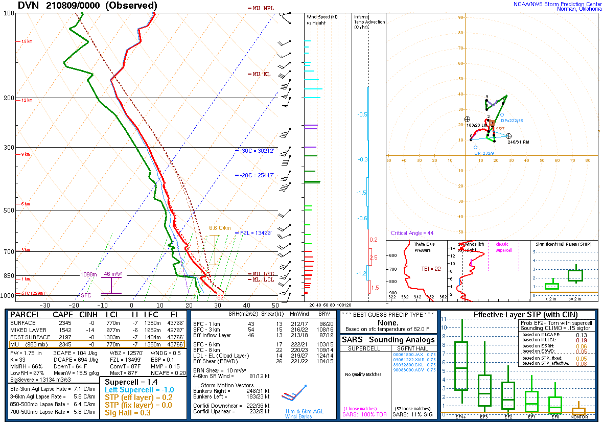
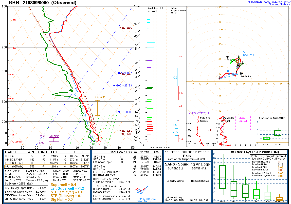
| SPC Day 1 Outlook 13 UTC | SPC Day 1 Outlook 20 UTC | DVN Sounding Saturday Afternoon | GRB Sounding Saturday Evening |
Messaging:
 |
 |
 |
 |
| NWS Milwaukee discussing the busy days ahead with multiple chances for severe weather into next week. | Severe Thunderstorm Watch Issued Saturday Afternoon. | Heavy rainfall possible along the lakeshore. | Heavy rainfall possible along the lakeshore. |
Overview
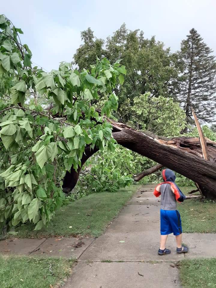
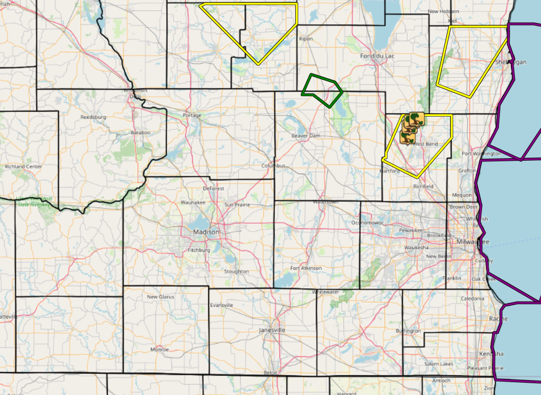
Thunderstorms developed Sunday afternoon and evening along a northward moving warm front and moisture boundary. A few individual thunderstorms developed that produced wind damage in Washington and Sheboygan counties. Otherwise most storms stayed below severe limits.
Radar:
Storms developed across western and southern Wisconsin along a northward moving warm front. Most of the activity stayed below severe limits except for a thunderstorm over Washington and Sheboygan counties that was able to produce damaging wind gusts.
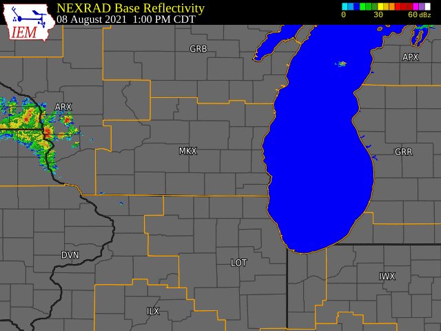 |
| Radar loop with warnings issued by NWS Offices for Sunday August 8th. |
Photos:
 |
 |
 |
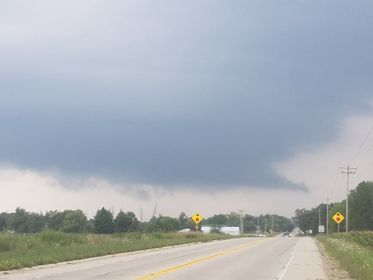
| Shelf Cloud in distance from Nicole Pinter | Kewauskum Damage from Fox 6 | Kewauskum Damage from Fox 6 |
Storm Reports
Header
 |
 |
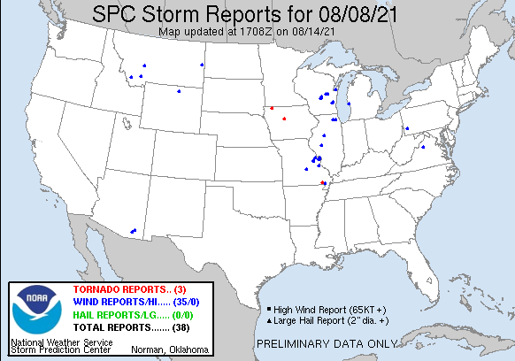
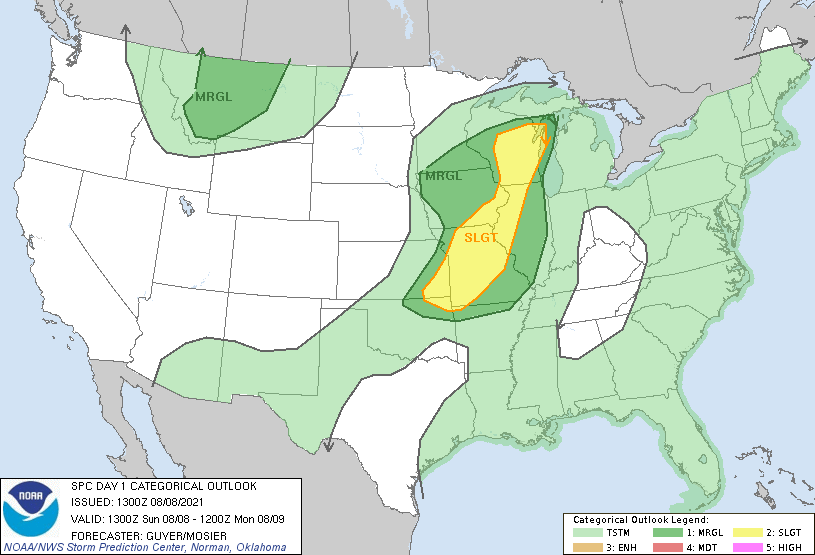
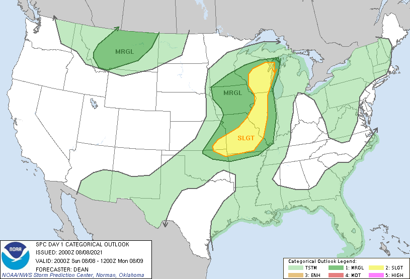
| SPC Storm Reports for Aug. 8th 2021 | Link to Map of storm reports |
								PRELIMINARY LOCAL STORM REPORT...SUMMARY
								NATIONAL WEATHER SERVICE MILWAUKEE/SULLIVAN WI
								734 PM CDT SUN AUG 15 2021

								..TIME...   ...EVENT...      ...CITY LOCATION...     ...LAT.LON...
								..DATE...   ....MAG....      ..COUNTY LOCATION..ST.. ...SOURCE....
								            ..REMARKS..

								0507 PM     TSTM WND DMG     4 NE ALLENTON           43.45N 88.28W
								08/08/2021                   WASHINGTON         WI   TRAINED SPOTTER

								            REPORTS OF A TWO FOOT DIAMETER TREE DOWN
								            ACROSS BEAVER DAM ROAD JUST WEST OF TOWNLINE
								            RD AND A 12 INCH DIAMETER BRANCH DOWN ACROSS
								            TOWNLINE RD.

								0511 PM     TSTM WND DMG     3 SW KEWASKUM           43.49N 88.27W
								08/08/2021                   WASHINGTON         WI   TRAINED SPOTTER

								            ONE FOOT DIAMETER TREE DOWN ACROSS RIDGE RD.
								            ONE QUARTER MILE WEST OF HIGHLAND DR.
								            MULTIPLE SIX INCH DIAMETER BRANCHES DOWN
								            NEARBY AS WELL.

								0515 PM     TSTM WND DMG     2 WSW KEWASKUM          43.51N 88.26W
								08/08/2021                   WASHINGTON         WI   TRAINED SPOTTER

								            POWER POLES SNAPPED AND LINES DOWN AT THE
								            INTERSECTION OF COUNTY ROAD H AND HIGHLAND
								            DRIVE.

								0516 PM     TSTM WND DMG     KEWASKUM                43.52N 88.23W
								08/08/2021                   WASHINGTON         WI   BROADCAST MEDIA

								            TREE DOWN AND SPLIT IN KEWASKUM.

								&&

								$$
Environment:
 |
 |
 |
 |
| SPC Day 1 Outlook 13 UTC | SPC Day 1 Outlook 20 UTC | DVN Sounding Sunday Evening | GRB Sounding Sunday Evening |
Messaging:
 |
 |
| NWS Milwaukee discusses continued severe weather threat next few days. | Severe Thunderstorm Watch Issued for Sunday afternoon. |
Overview
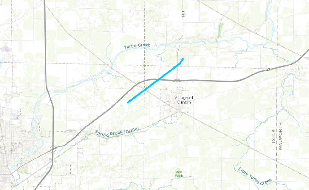
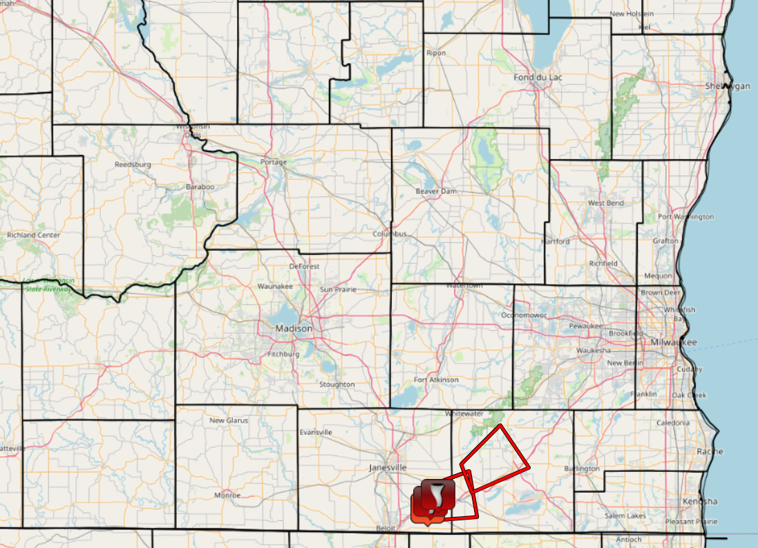
Storms started shortly after sunrise as an initial shortwave moved through Wisconsin. Moderate to occassionaly heavy rainfall occurred for much of Monday morning into the early afternoon hours. Then by early afternoon there was enough clearing and decent southerly winds to allow for additional thunderstorms to develop along a weak front that was moving through. These thunderstorms were able to produce multiple tornadoes with the majority of the activity across northern Illinois. However, one tornado was reported in Clinton, Wisconsin with this activity.
Tornado:
|
Tornado - Clinton
|
||||||||||||||||
The Enhanced Fujita (EF) Scale classifies tornadoes into the following categories:
| EF0 Weak 65-85 mph |
EF1 Moderate 86-110 mph |
EF2 Significant 111-135 mph |
EF3 Severe 136-165 mph |
EF4 Extreme 166-200 mph |
EF5 Catastrophic 200+ mph |
|
|||||
Radar:
Moderate to occasionally heavy rainfall occurred through much of the morning and into the afternoon hours with little in the way of severe weather. Then by the afternoon hours a weak front moving into northern Illinois was able to produce multiple photogenic tornadoes. One tornado occurred in Clinton, WI.
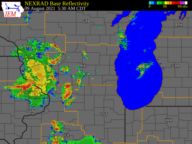 |
| Radar loop with warnings issued by NWS Offices for Monday August 9th. |
Photos:
 |
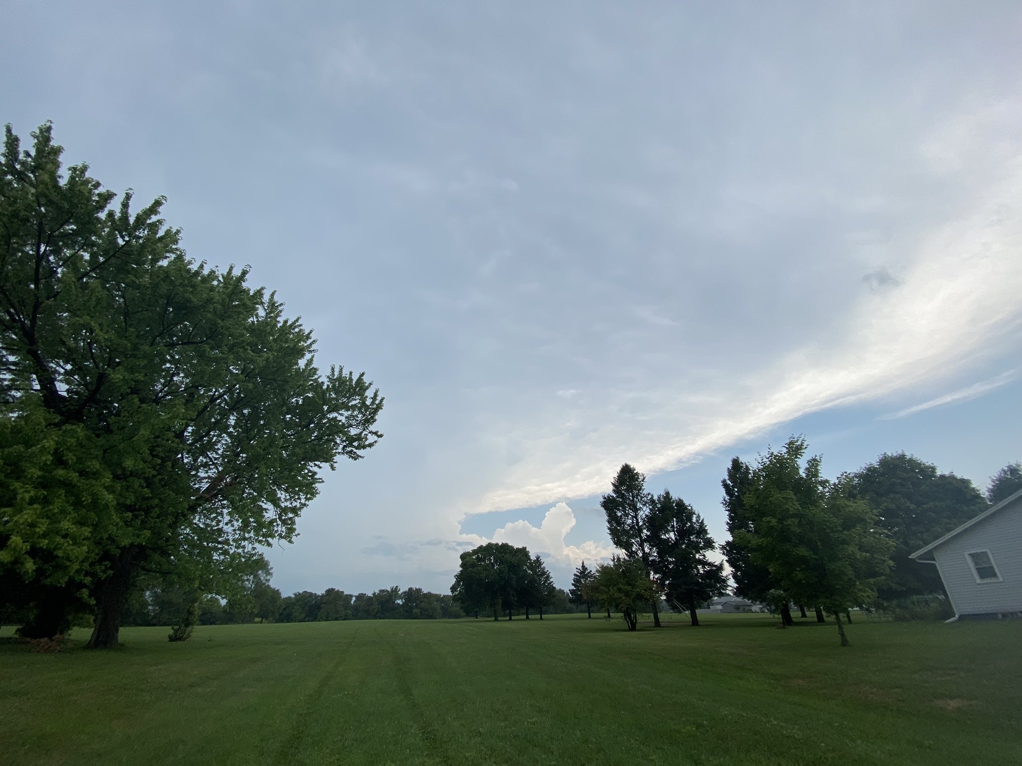 |
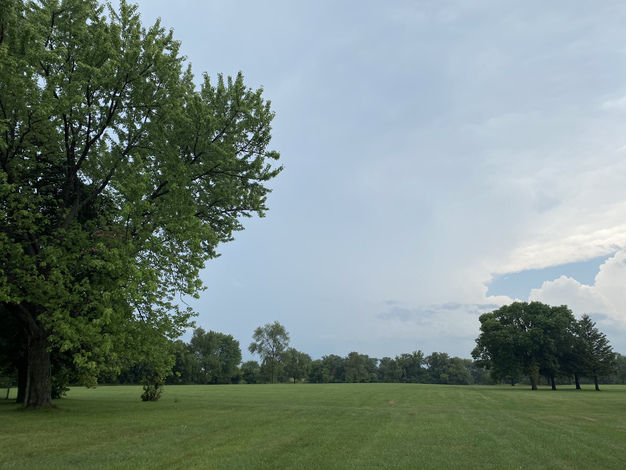
| View of thunderstorm anvil near Janesville from @JordanWX | View of thunderstorm anvil near Janesville from @JordanWX |
Storm Reports
Header
 |
 |
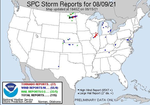
| SPC Storm Reports for Aug. 9th 2021 | Link to Map of storm reports |
								PRELIMINARY LOCAL STORM REPORT...SUMMARY
								NATIONAL WEATHER SERVICE MILWAUKEE/SULLIVAN WI
								746 PM CDT SUN AUG 15 2021

								..TIME...   ...EVENT...      ...CITY LOCATION...     ...LAT.LON...
								..DATE...   ....MAG....      ..COUNTY LOCATION..ST.. ...SOURCE....
								            ..REMARKS..

								0255 PM     FUNNEL CLOUD     CLINTON                 42.56N 88.87W
								08/09/2021                   ROCK               WI   PUBLIC

								            PUBLIC REPORTS OF A FUNNEL CLOUD WEST OF
								            CLINTON RELAYED THROUGH THE ROCK COUNTY
								            SHERIFFS OFFICE. STORM CHASER ALSO REPORTED
								            A ROTATING WALL CLOUD 4 MILES WEST OF
								            CLINTON AROUND 2:50 PM.

								0258 PM     TORNADO          1 N CLINTON             42.58N 88.86W
								08/09/2021                   ROCK               WI   PUBLIC

								            MULTIPLE PUBLIC REPORTS OF A TORNADO WITH
								            INTERMITTENT TOUCH DOWNS JUST NORTH OF I-43
								            ALONG WI WHY 140.

								0302 PM     TORNADO          3 SE AVALON             42.60N 88.83W
								08/09/2021                   ROCK               WI   FIRE DEPT/RESCUE

								            FIRE DEPT REPORTS A TOUCH DOWN NEAR THE
								            INTERSECTION OF SOUTH CARVER ROCK ROAD AND
								            EAST CREEK ROAD.

								&&

								$$
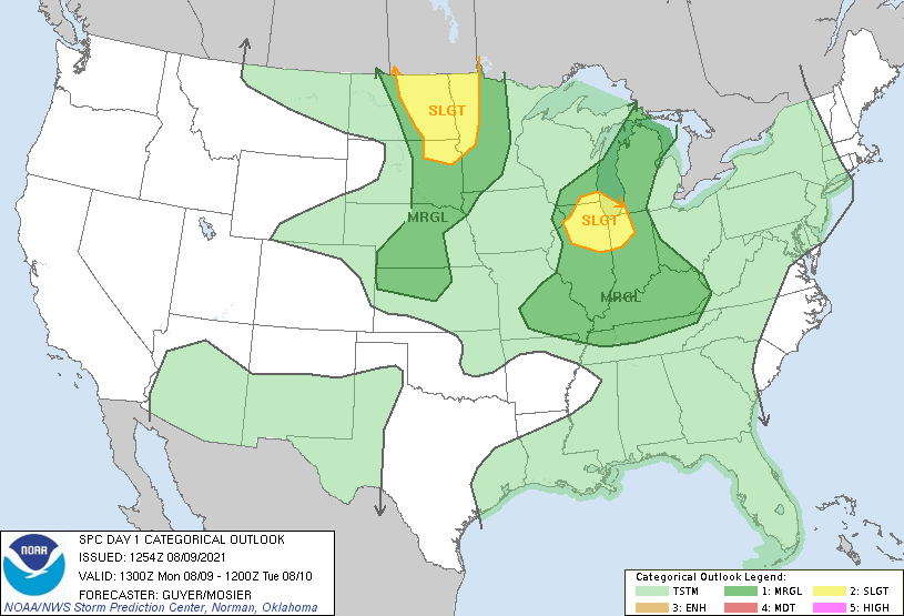
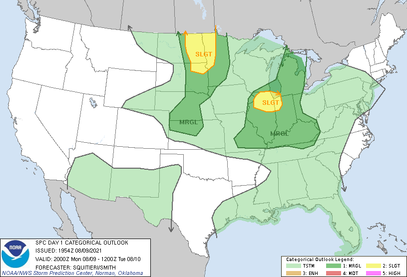
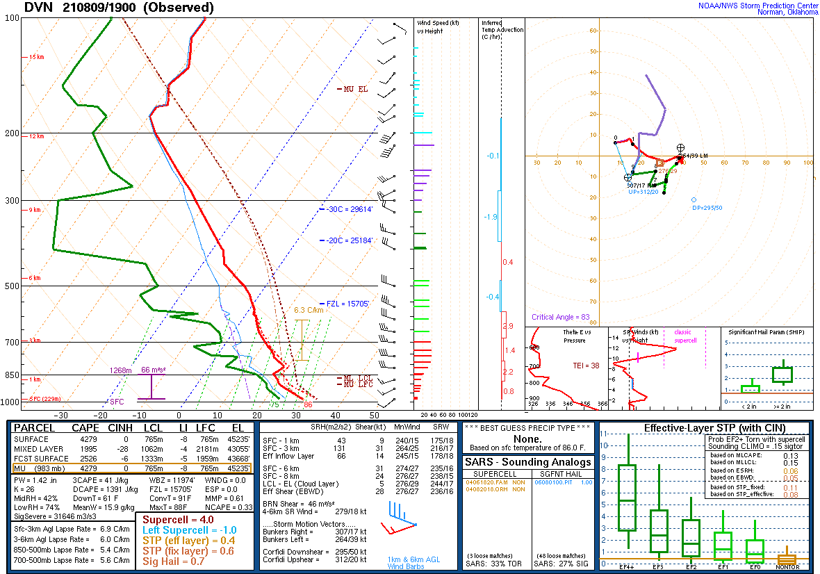
Environment:
 |
 |
 |
 |
| SPC Day 1 Outlook 13 UTC | SPC Day 1 Outlook 20 UTC | DVN Sounding Monday Afternoon | GRB Sounding Monday Evening |
Messaging:
 |
| NWS Milwaukee multiple rounds of storms with main severe threat in southern and southeast Wisconsin. |
Overview
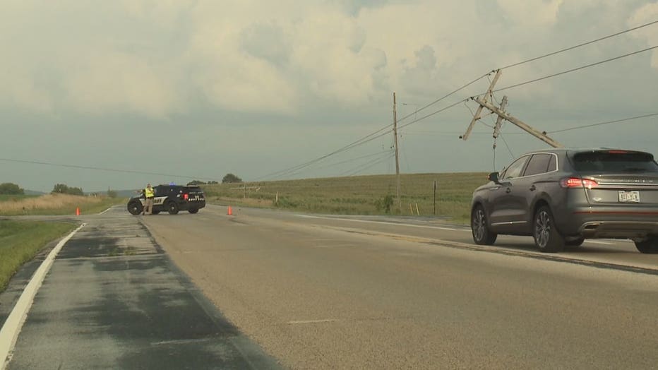
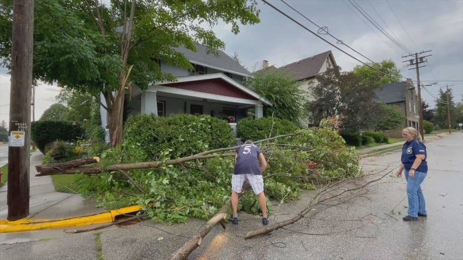
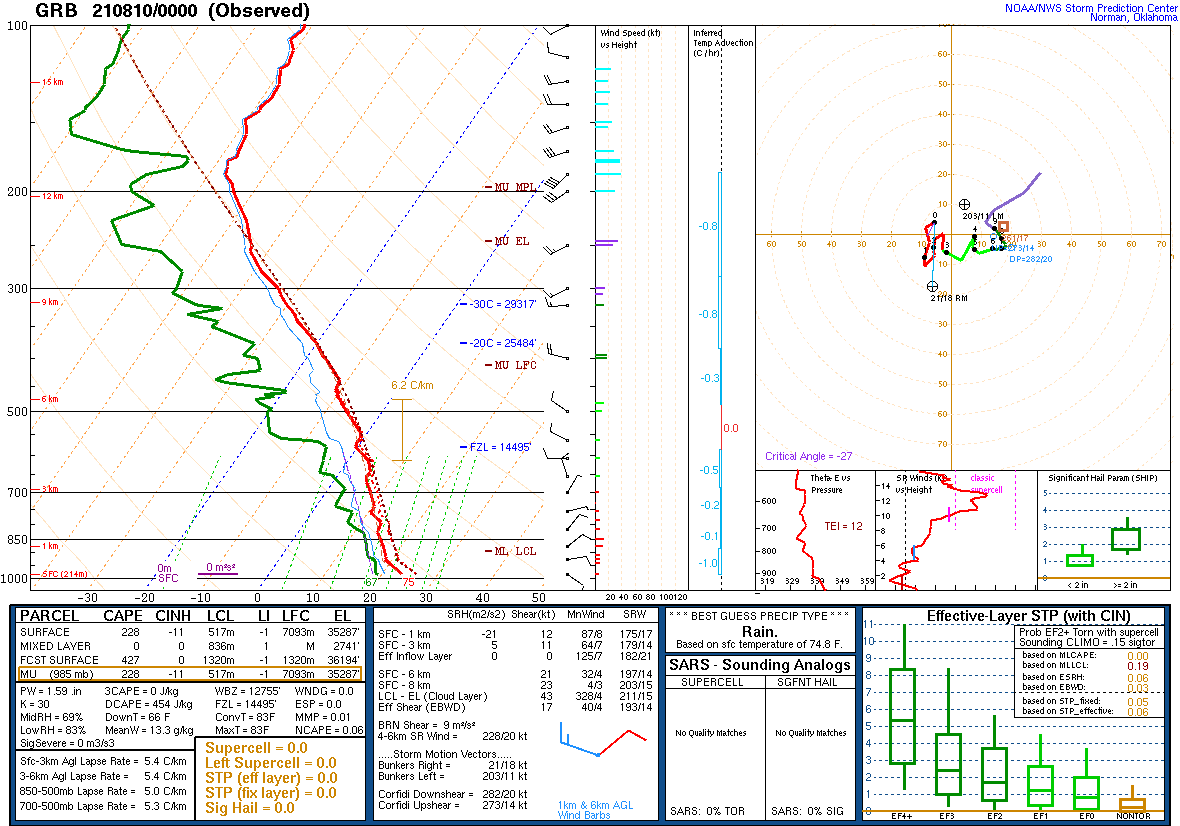
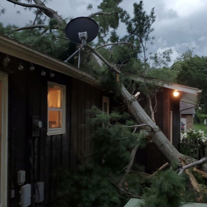
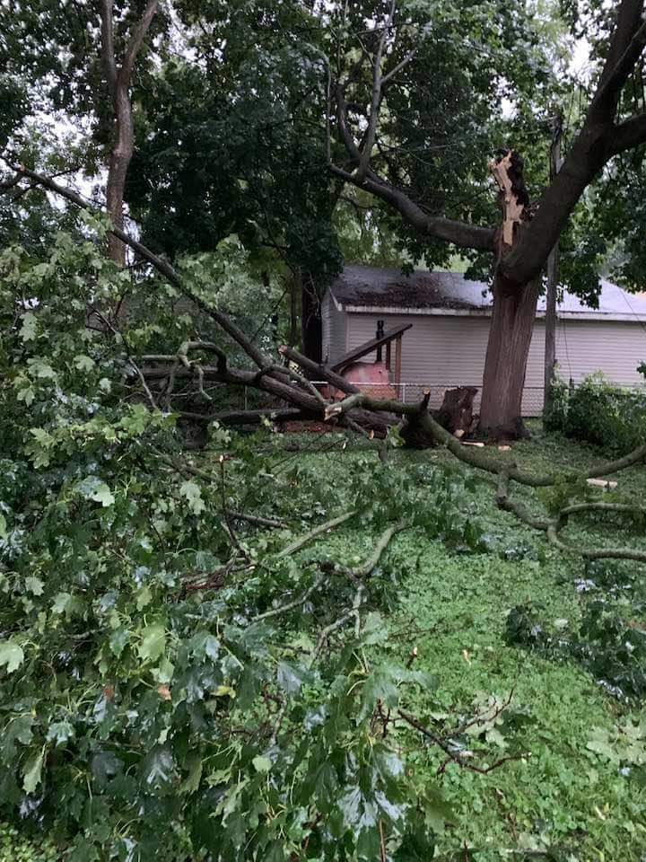
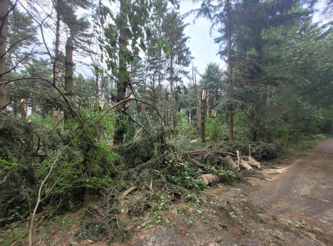
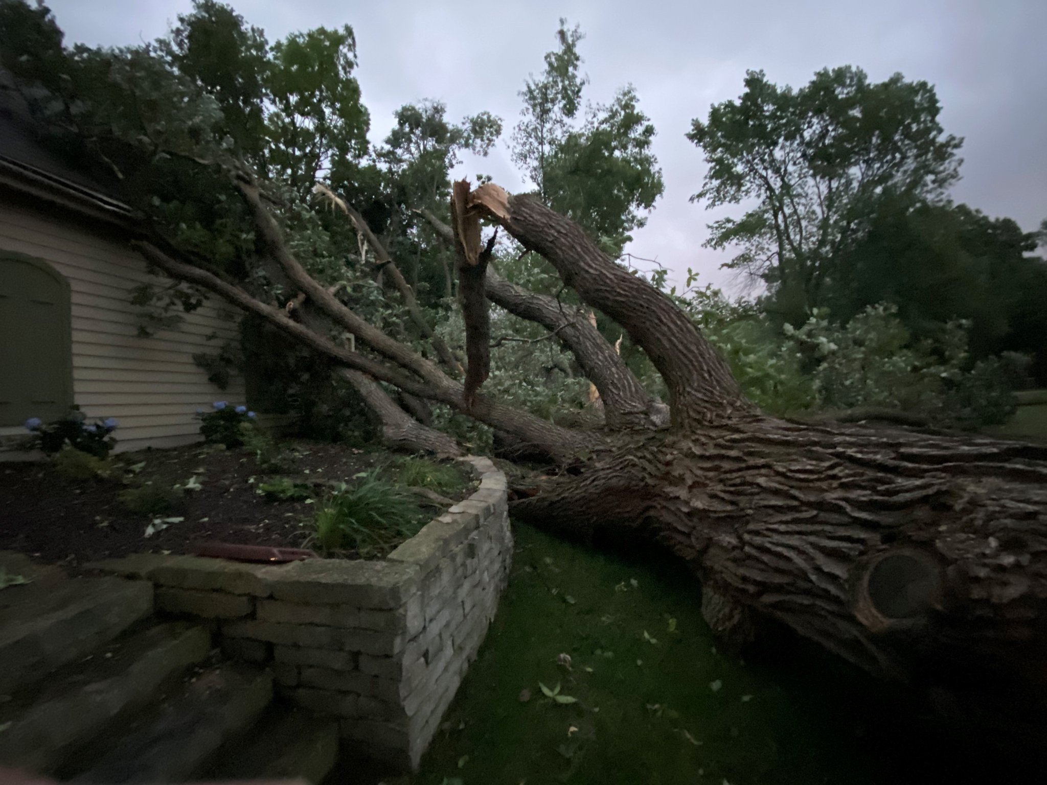
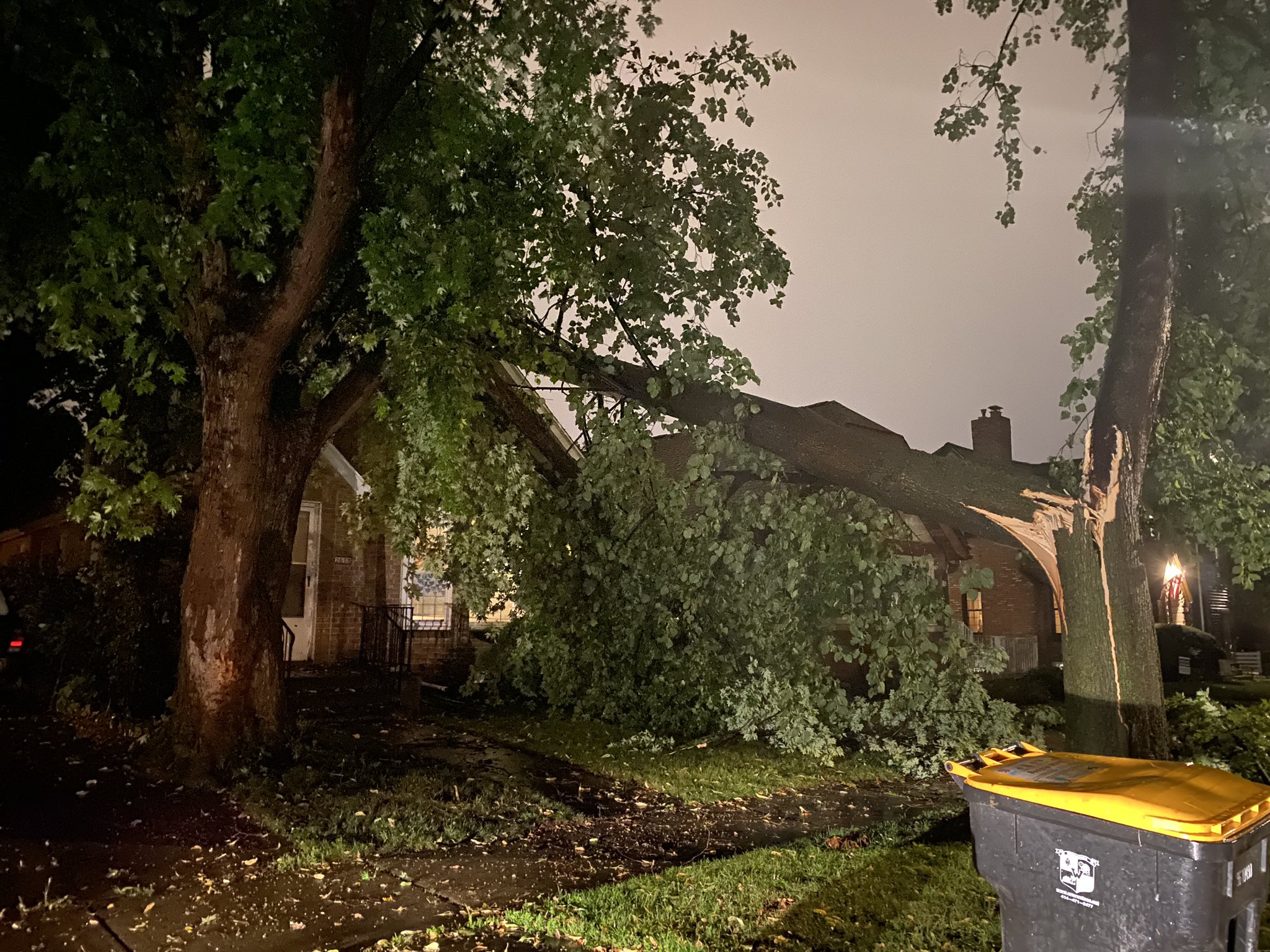
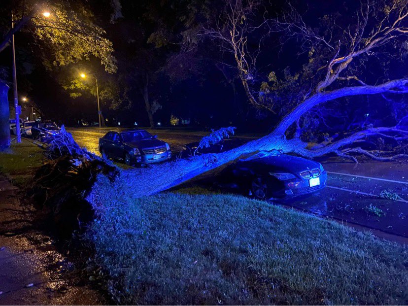
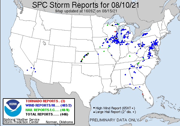
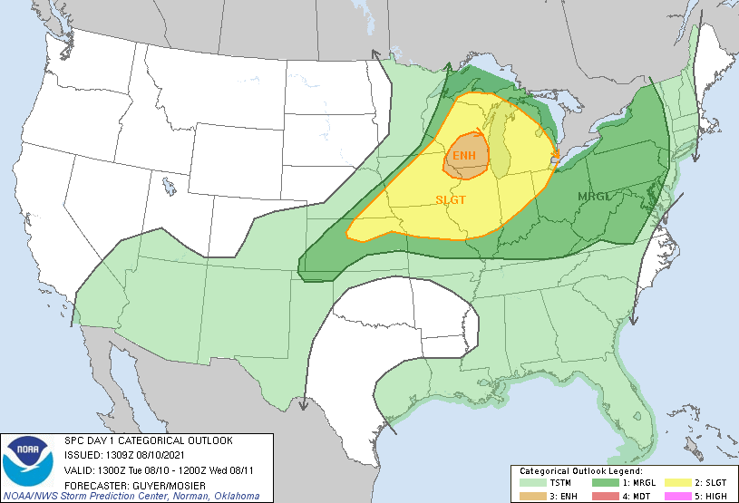
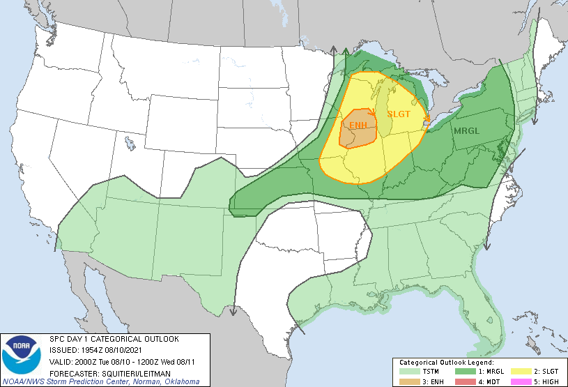
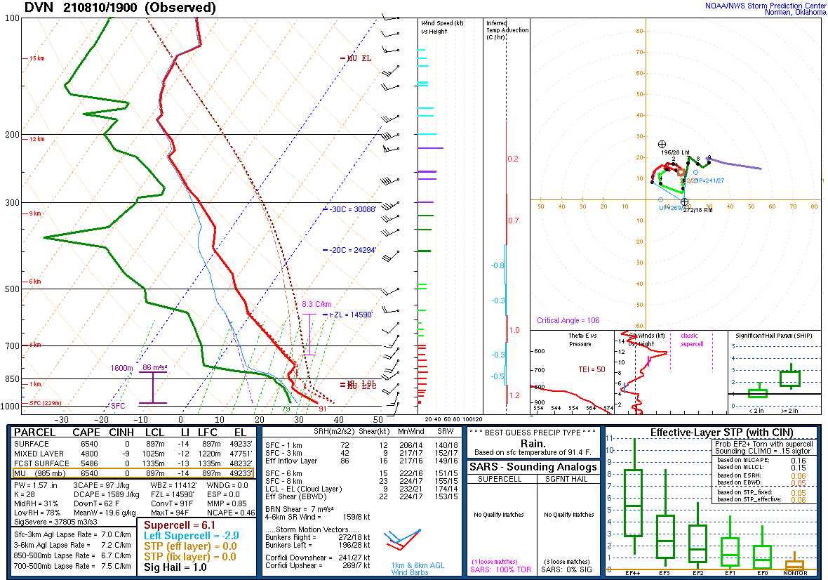
A strong to severe line of thunderstorms developed across far southwestern Wisconsin Tuesday afternoon. As this line moved east it initially had a gust front get out ahead of the main line of storms which resulted in only brief severe gusts. But by the time got east of Madison additional thunderstorms were moving north out of Illinois and this resulted in widespread severe wind gusts occuring over much of southern and southeastern Wisconsin. We-Energies reported over 200,000 customers without power, which was the highest number ever for the company. The environment that day featured near record instability or CAPE based on the soundings from Davenport, IA and Green Bay, WI. This combined with hot surface temps in the 90s set the stage for the strong to severe wind potential to be realized.
Radar:
A complex of storms moved out of Iowa and into southern and central Wisconsin Tuesday afternoon. This complex morphed into a strong to severe line of thunderstorms that marched eastward and gained strength as it approached Lake Michigan. Widespread tree damage and power outages were reported with this line.
 |
| Radar loop with warnings issued by NWS Offices for Tuesday August 10th. |
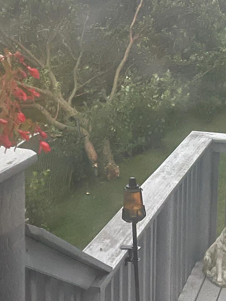
Photos
Header
 |
 |
 |
 |
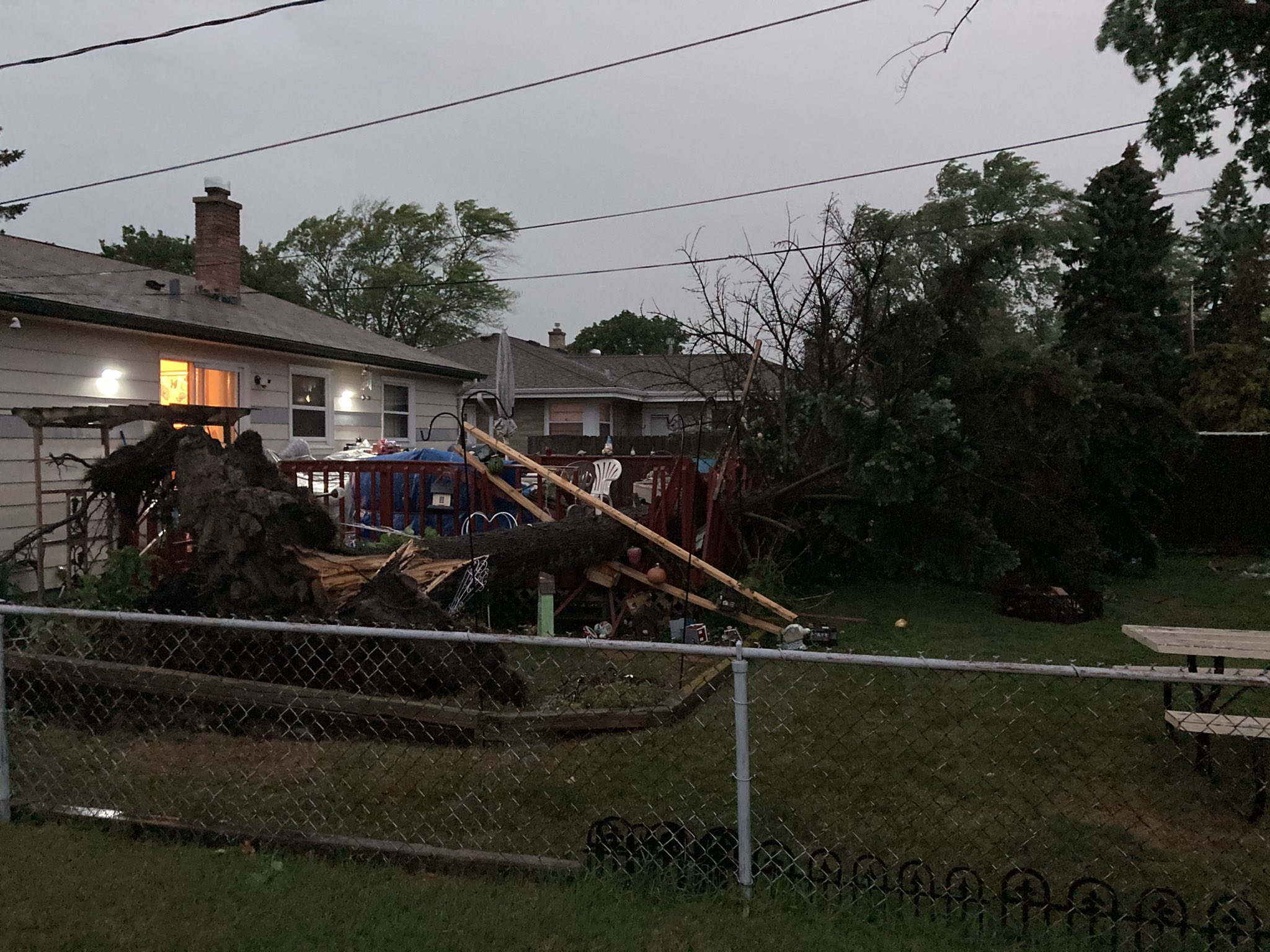
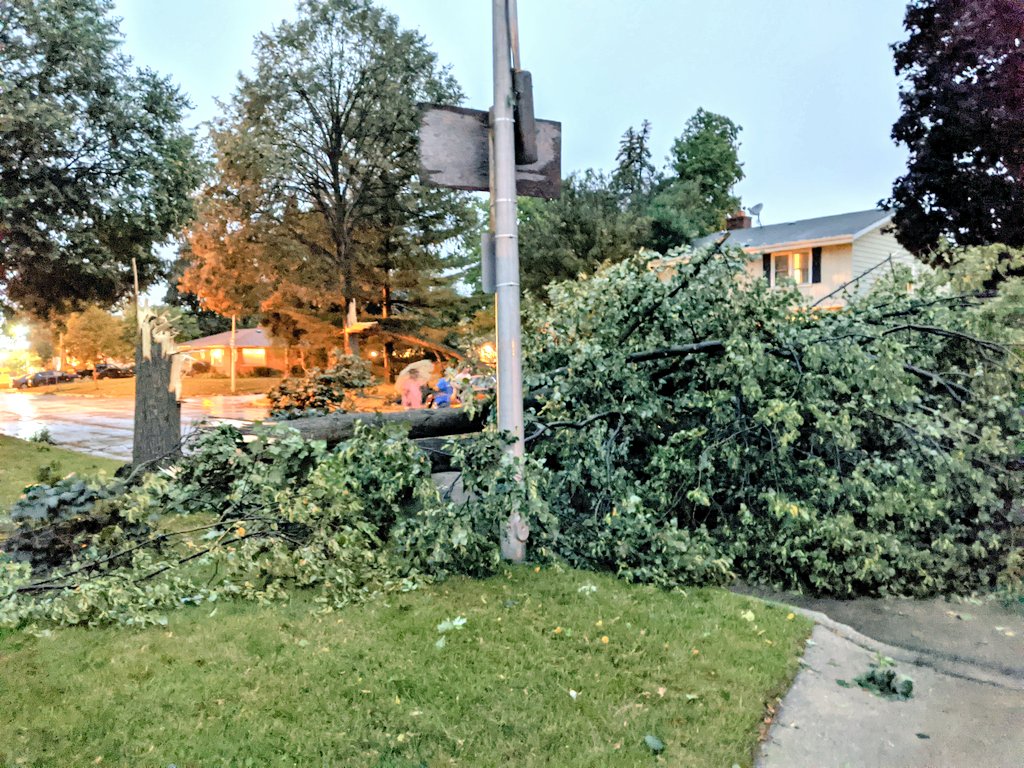
| Tree damage Whitewater from Andrew Kyllonen | Tree damage in Waukesha from Anita Ward | Limbs on house in Madison from NBC 15 | Tree damage in Madison from Chad Woodward |
 |
 |
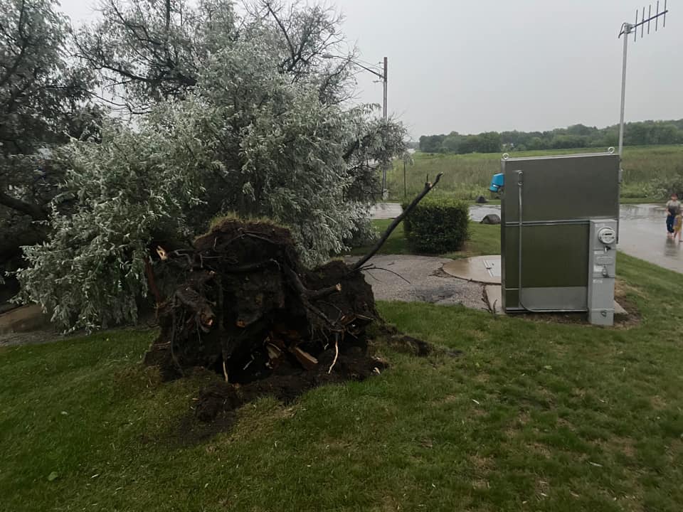 |
 |
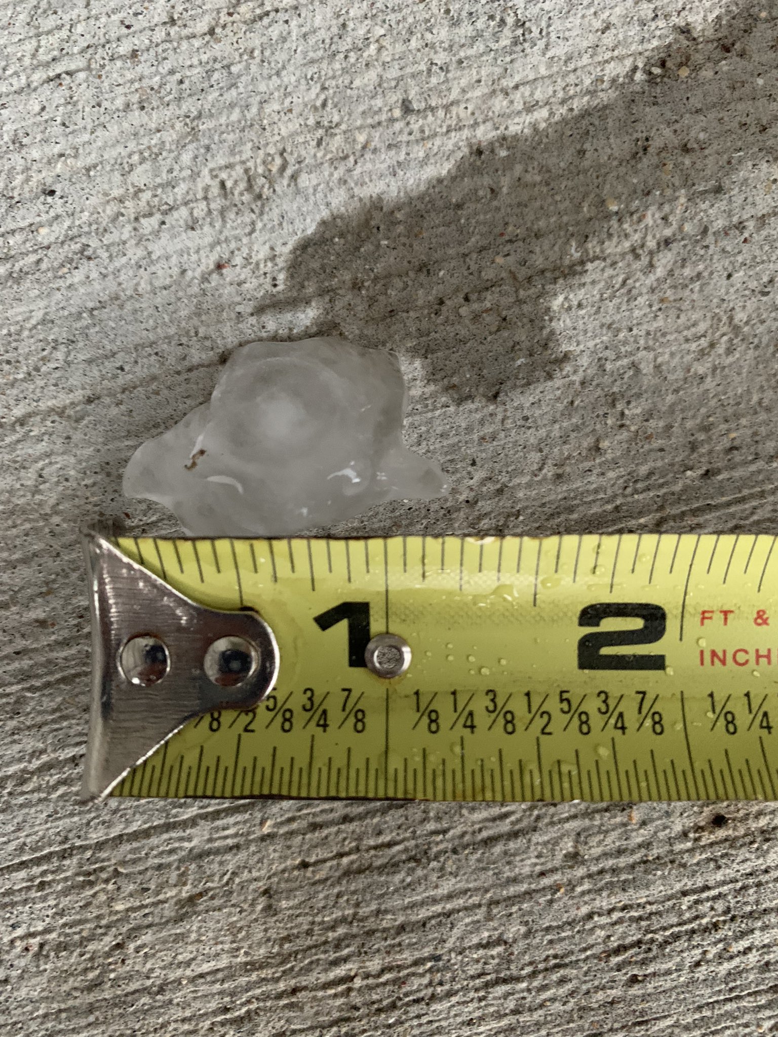
| Damage to metal building near Janesville | Dime size hail in Mineral Point from Michele Hughes | Tree damage Watertown | Trees snapped in La Grange, WI |
 |
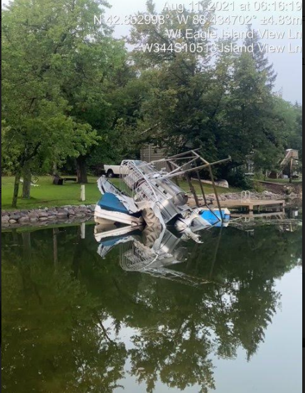 |
 |
 |
| Tree damage in Waukesha from Michelle Pakula | Overturned boat on Eagle Spring Lake | Possible roof damage in Madison from NBC 15 | Tree damage in La Grange, WI |
 |
 |
 |
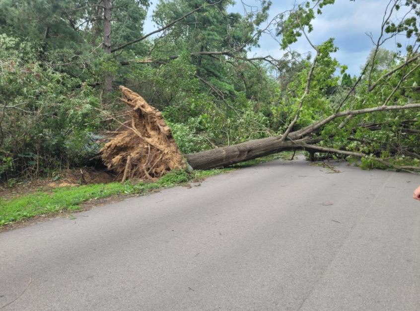 |
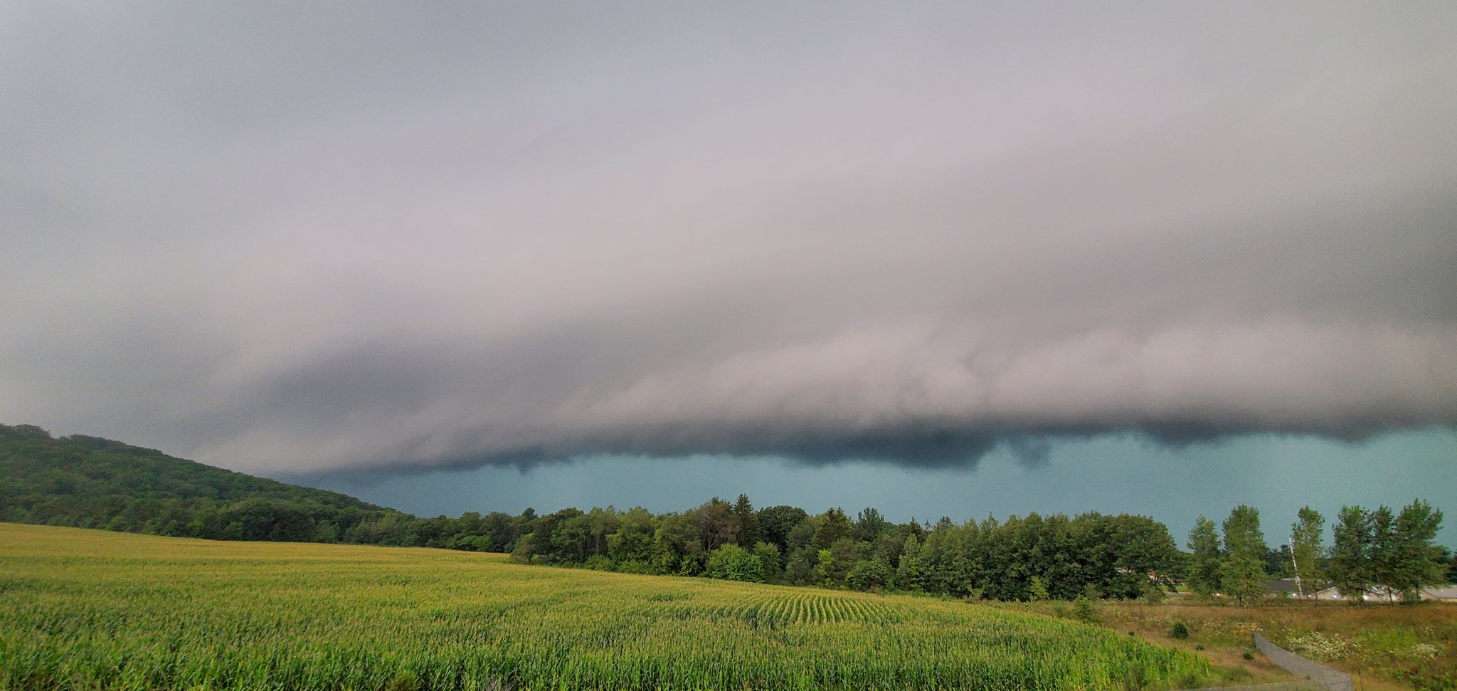
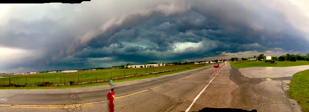
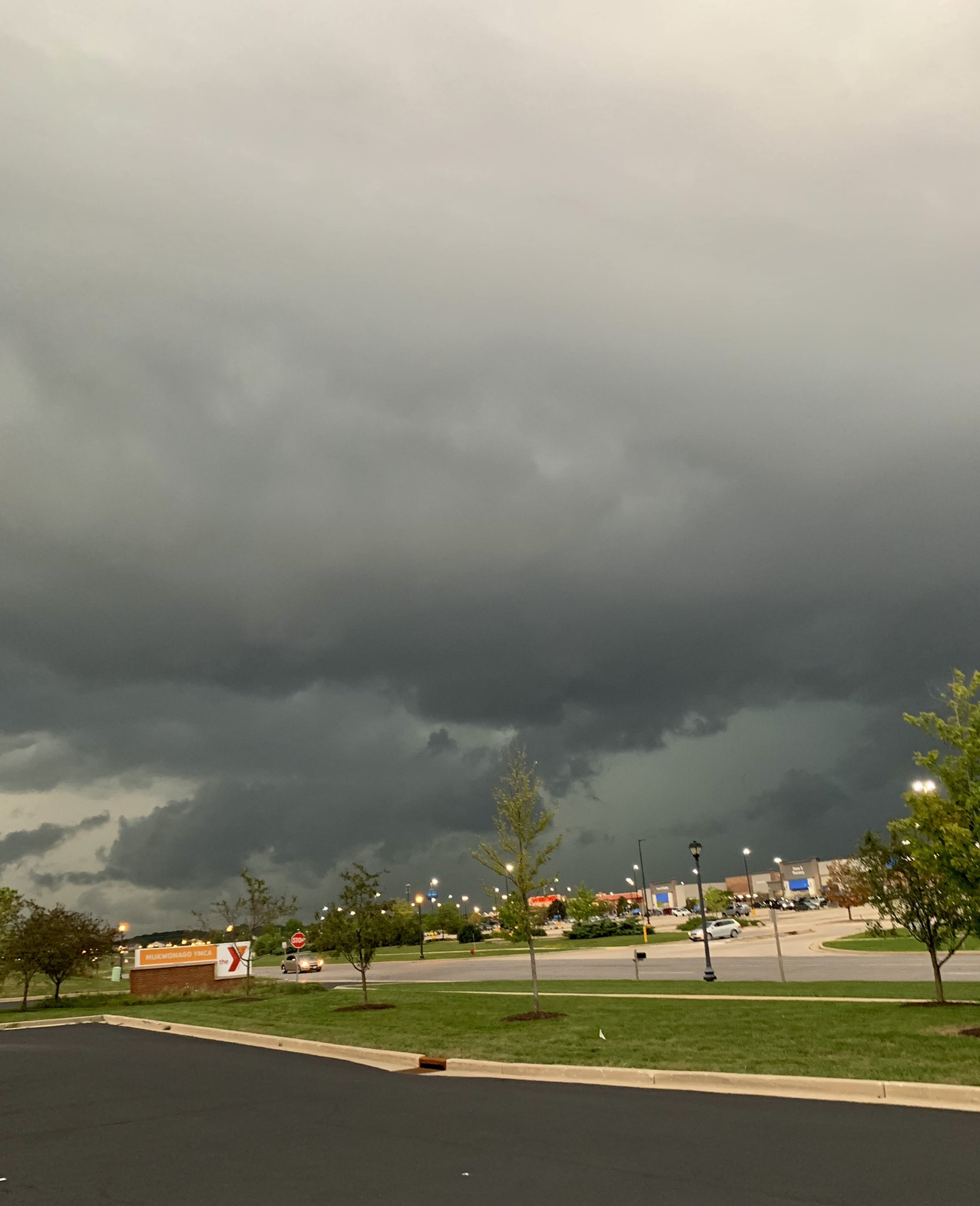
| Shelf Cloud photo from Tracy Campbell in Madison | Shelf Cloud photo from @razgriz23 in Round Lake | Shelf Cloud photo Waukesha | Tree damage in La Grange, WI |
 |
 |
 |
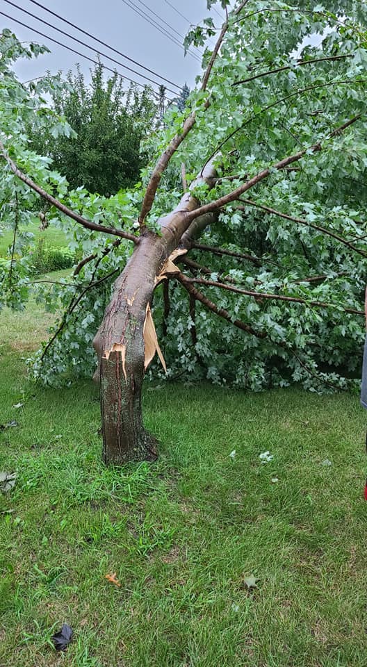 |
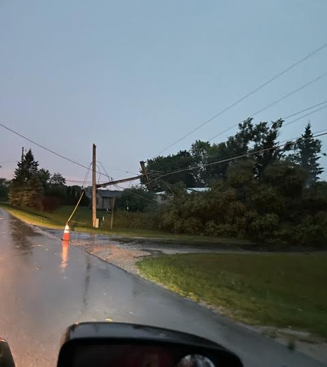
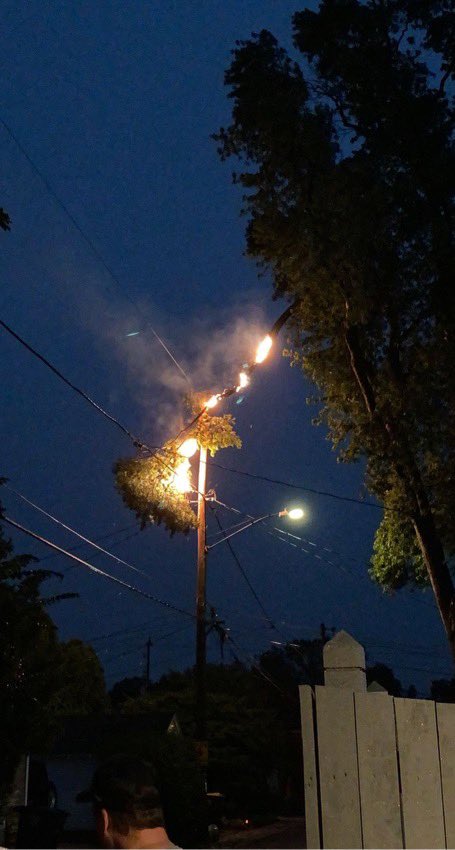
| Snapped powerlines in Eagle | View of approaching storm from Steve Morschauser in Mukwanago | Tree branch on power line caught on fire in Tosa from Lisa Sink | Tree damage in Spring Green from Jolean Louis |
 |
 |
 |
 |
| Large tree down in New Berlin from WISN | Tree on house in Wauwatosa from Caroline Reinwald | Tree on car in Riverwest from Caroline Reinwald | Tree on house in Milwaukee from Author Quardeay |
 |
 |
 |
 |
| Tree uprooted in Verona from Tamara A. | Tree uprooted in Kenosha relayed from Sam Kuffel | Trees snapped in Milwaukee from Nicole Haase | Tree split in Milwaukee from Aliza Werner |
Storm Reports
Header
 |
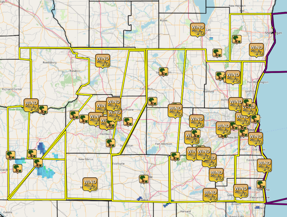 |
| SPC Storm Reports for Aug. 10th 2021 | Link to Map of storm reports |
PRELIMINARY LOCAL STORM REPORT...SUMMARY NATIONAL WEATHER SERVICE MILWAUKEE/SULLIVAN WI 912 PM CDT SUN AUG 15 2021 ..TIME... ...EVENT... ...CITY LOCATION... ...LAT.LON... ..DATE... ....MAG.... ..COUNTY LOCATION..ST.. ...SOURCE.... ..REMARKS.. 0437 PM TSTM WND DMG REWEY 42.84N 90.40W 08/10/2021 IOWA WI 911 CALL CENTER IOWA CO. DISPATCH RELAYS REPORT OF A TREE DOWN ON HUGHIT STREET. TIME ESTIMATED FROM RADAR. 0439 PM TSTM WND DMG BELMONT 42.74N 90.33W 08/10/2021 LAFAYETTE WI 911 CALL CENTER LAFAYETTE CO DISPATCH RELAYS REPORT OF DAMAGE TO HOME CAUSED BY A FALLING TREE. TIME ESTIMATED FROM RADAR. 0445 PM TSTM WND DMG 7 SSE MINERAL POINT 42.78N 90.12W 08/10/2021 LAFAYETTE WI 911 CALL CENTER LAFAYETTE CO DISPATCH RELAYS REPORT OF TREE DOWN ON OLSON LANE. TIME ESTIMATED FROM RADAR. 0447 PM TSTM WND DMG 1 SSE MINERAL POINT 42.85N 90.18W 08/10/2021 IOWA WI 911 CALL CENTER IOWA CO DISPATCH RELAYS REPORT OF A TREE DOWN ON STATE STREET. TIME ESTIMATED FROM RADAR. 0500 PM TSTM WND GST 6 WNW SPRING GREEN 43.21N 90.19W 08/10/2021 M49 MPH SAUK WI ASOS LNR - LONE ROCK. 0505 PM TSTM WND DMG SPRING GREEN 43.18N 90.07W 08/10/2021 SAUK WI PUBLIC SMALL TREE BRANCHES DOWN. 0505 PM TSTM WND DMG SPRING GREEN 43.18N 90.07W 08/10/2021 SAUK WI FIRE DEPT/RESCUE POWER POLES SNAPPED. 0525 PM TSTM WND DMG BLACK EARTH 43.14N 89.75W 08/10/2021 DANE WI EMERGENCY MNGR TREES AND WIRES DOWN. 0530 PM TSTM WND DMG CROSS PLAINS 43.11N 89.65W 08/10/2021 DANE WI EMERGENCY MNGR TREES AND WIRES DOWN. 0535 PM TSTM WND GST 3 ENE MONROE 42.62N 89.59W 08/10/2021 M51 MPH GREEN WI AWOS 0540 PM TSTM WND GST 1 NW WAUNAKEE 43.19N 89.46W 08/10/2021 M50 MPH DANE WI PUBLIC 0542 PM TSTM WND DMG MIDDLETON 43.10N 89.51W 08/10/2021 DANE WI EMERGENCY MNGR TREES AND WIRES DOWN. 0543 PM TSTM WND GST 1 WNW MIDDLETON 43.11N 89.53W 08/10/2021 M51 MPH DANE WI AWOS MDD. 0548 PM TSTM WND GST 1 SSE PORTAGE 43.54N 89.46W 08/10/2021 E60 MPH COLUMBIA WI TRAINED SPOTTER EST 40-60 MPH GUSTS WITH BRANCHES DOWN AND HOUSE STRUCK BY LIGHTNING. 0548 PM TSTM WND GST 1 E SHOREWOOD HILLS 43.08N 89.42W 08/10/2021 M53 MPH DANE WI PUBLIC ON TOP OF BLDG ON UW-MADISON CAMPUS. 0550 PM TSTM WND DMG MADISON 43.08N 89.38W 08/10/2021 DANE WI EMERGENCY MNGR TREES AND WIRES DOWN. 0553 PM TSTM WND GST 3 NNE MAPLE BLUFF 43.14N 89.34W 08/10/2021 M43 MPH DANE WI ASOS MSN - DANE COUNTY REGIONAL AIRPORT. 0554 PM TSTM WND GST 1 W WINDSOR 43.22N 89.35W 08/10/2021 E50 MPH DANE WI PUBLIC 0557 PM TSTM WND DMG OREGON 42.93N 89.38W 08/10/2021 DANE WI EMERGENCY MNGR TREES AND WIRES DOWN. 0600 PM TSTM WND DMG COTTAGE GROVE 43.09N 89.20W 08/10/2021 DANE WI EMERGENCY MNGR TREES AND WIRES DOWN. 0615 PM TSTM WND DMG 2 SW JANESVILLE 42.66N 89.04W 08/10/2021 ROCK WI PUBLIC TREE SPLIT...LARGE LIMB. 0620 PM TSTM WND DMG 5 NNE WATERLOO 43.24N 88.95W 08/10/2021 DODGE WI LAW ENFORCEMENT POWER LINES DOWN IN TOWN OF PORTLAND. 0630 PM TSTM WND DMG 1 S BEAVER DAM 43.46N 88.84W 08/10/2021 DODGE WI LAW ENFORCEMENT POWER LINES DOWN. 0635 PM TSTM WND DMG 1 ENE WATERTOWN 43.20N 88.71W 08/10/2021 DODGE WI PUBLIC MEDIUM SIZE TREE UPROOTED. 0635 PM TSTM WND GST 1 S WATERTOWN 43.17N 88.72W 08/10/2021 M44 MPH JEFFERSON WI AWOS RYV - WATERTOWN. 0635 PM TSTM WND GST 2 ENE EAST TROY 42.80N 88.37W 08/10/2021 M52 MPH WALWORTH WI AWOS 57C. 0640 PM TSTM WND DMG 1 E WHITEWATER 42.83N 88.72W 08/10/2021 WALWORTH WI PUBLIC LARGE BRANCHES DOWN ACROSS EASTERN PORTION OF TOWN. 0650 PM TSTM WND GST 3 SW EAGLE 42.85N 88.53W 08/10/2021 M68 MPH WAUKESHA WI TRAINED SPOTTER 0655 PM TSTM WND DMG 2 SE EAGLE 42.86N 88.43W 08/10/2021 WAUKESHA WI EMERGENCY MNGR LARGE TREE FELL ON HOUSE AND CASUED SIGNIFICANT DAMAGE. 0655 PM TSTM WND DMG EAGLE 42.88N 88.46W 08/10/2021 WAUKESHA WI TRAINED SPOTTER LARGE LIMBS DOWN...POWER OUT AND 0.75 INCH HAIL. 0655 PM TSTM WND GST 2 WSW FOND DU LAC 43.77N 88.49W 08/10/2021 M45 MPH FOND DU LAC WI ASOS FLD. 0658 PM TSTM WND GST 3 SE EAGLE 42.85N 88.43W 08/10/2021 M77 MPH WAUKESHA WI TRAINED SPOTTER LARGE TREES SNAPPED AND UPROOTED. 0700 PM TSTM WND GST PELL LAKE 42.54N 88.36W 08/10/2021 E60 MPH WALWORTH WI PUBLIC BLOOMFIELD...NO POWER. 0703 PM TSTM WND GST 4 SSE SULLIVAN 42.97N 88.55W 08/10/2021 M54 MPH JEFFERSON WI OFFICIAL NWS OBS AT WFO MKX. 0705 PM TSTM WND DMG 2 WSW DOUSMAN 43.00N 88.51W 08/10/2021 WAUKESHA WI AMATEUR RADIO LARGE BRANCHES DOWN ACROSS THE ROAD. 0705 PM TSTM WND DMG 4 E ALLENTON 43.43N 88.26W 08/10/2021 WASHINGTON WI PUBLIC SMALL GARDEN SHED DESTROYED. 0707 PM TSTM WND DMG 1 SSE WAUKESHA 43.00N 88.23W 08/10/2021 WAUKESHA WI PUBLIC DAMAGE TO A BUSINESS MARQUEE SIGN...KNOCKED OVER. 0710 PM TSTM WND GST 1 S OCONOMOWOC 43.09N 88.50W 08/10/2021 M60 MPH WAUKESHA WI NWS EMPLOYEE EST 50-60 MPH GUSTS. 0710 PM TSTM WND DMG 1 SSE WEST BEND 43.41N 88.18W 08/10/2021 WASHINGTON WI PUBLIC ORNAMENTAL TREE UPROOTED...PIC SHARED VIA SOCIAL MEDIA. 0715 PM TSTM WND DMG CAMPBELLSPORT 43.60N 88.29W 08/10/2021 FOND DU LAC WI PUBLIC LARGE TREE LIMBS DOWN...PIC VIA SOCIAL MEDIA. 0715 PM TSTM WND GST 2 N WAUKESHA 43.04N 88.23W 08/10/2021 M47 MPH WAUKESHA WI AWOS UES. 0715 PM TSTM WND DMG BROOKFIELD 43.06N 88.12W 08/10/2021 WAUKESHA WI PUBLIC LARGE TREE SNAPPED. 0715 PM TSTM WND GST 2 NW BURLINGTON 42.69N 88.30W 08/10/2021 M52 MPH RACINE WI AWOS BUU. 0715 PM TSTM WND GST 3 E WEST BEND 43.42N 88.13W 08/10/2021 M44 MPH WASHINGTON WI AWOS 0718 PM TSTM WND DMG WEST ALLIS 43.01N 88.02W 08/10/2021 MILWAUKEE WI PUBLIC LARGE TREE UPROOTED. 0719 PM TSTM WND GST 1 SE GERMANTOWN 43.22N 88.10W 08/10/2021 E55 MPH WASHINGTON WI PUBLIC 0720 PM TSTM WND GST 1 N BRISTOL 42.57N 88.05W 08/10/2021 E50 MPH KENOSHA WI PUBLIC 0720 PM TSTM WND DMG WAUWATOSA 43.06N 88.03W 08/10/2021 MILWAUKEE WI TRAINED SPOTTER LARGE BRANCH 12-15 INCHES IN DIAMETER DOWN. 0729 PM TSTM WND DMG WHITEFISH BAY 43.11N 87.90W 08/10/2021 MILWAUKEE WI PUBLIC LARGE TREE UPROOTED...POWER LINES DOWN. 0730 PM TSTM WND GST BROWN DEER 43.18N 87.97W 08/10/2021 M52 MPH MILWAUKEE WI BROADCAST MEDIA 0730 PM TSTM WND DMG 5 NW CASCADE 43.70N 88.09W 08/10/2021 SHEBOYGAN WI LAW ENFORCEMENT LARGE BRANCHES DOWN. 0730 PM TSTM WND GST 2 E BUTLER 43.11N 88.03W 08/10/2021 M47 MPH MILWAUKEE WI AWOS MWC. 0730 PM TSTM WND DMG 2 NNW KENOSHA 42.62N 87.84W 08/10/2021 KENOSHA WI PUBLIC LARGE TREE UPROOTED. 0733 PM TSTM WND GST 2 WSW SAINT FRANCIS 42.96N 87.90W 08/10/2021 M50 MPH MILWAUKEE WI ASOS MKE. 0739 PM TSTM WND GST 3 E ADELL 43.62N 87.89W 08/10/2021 M55 MPH SHEBOYGAN WI TRAINED SPOTTER NO DAMAGE IN VICINITY. 0740 PM TSTM WND DMG MEQUON 43.23N 87.98W 08/10/2021 OZAUKEE WI EMERGENCY MNGR SPORADIC DOWNED POWER LINES AND OLD/DEAD TREES DOWNED ACROSS SOUTHERN AND EASTERN PORTIONS OF THE COUNTY. 0743 PM TSTM WND GST 2 W NORTH BAY 42.76N 87.81W 08/10/2021 M49 MPH RACINE WI ASOS RAC. && $$
Environment:
 |
 |
 |
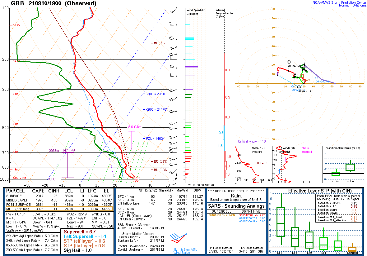 |
| SPC Day 1 Outlook 13 UTC | SPC Day 1 Outlook 20 UTC | DVN Sounding Early Afternoon Tuesday | GRB Sounding Early Afternoon Tuesday |
Messaging:
 |
 |
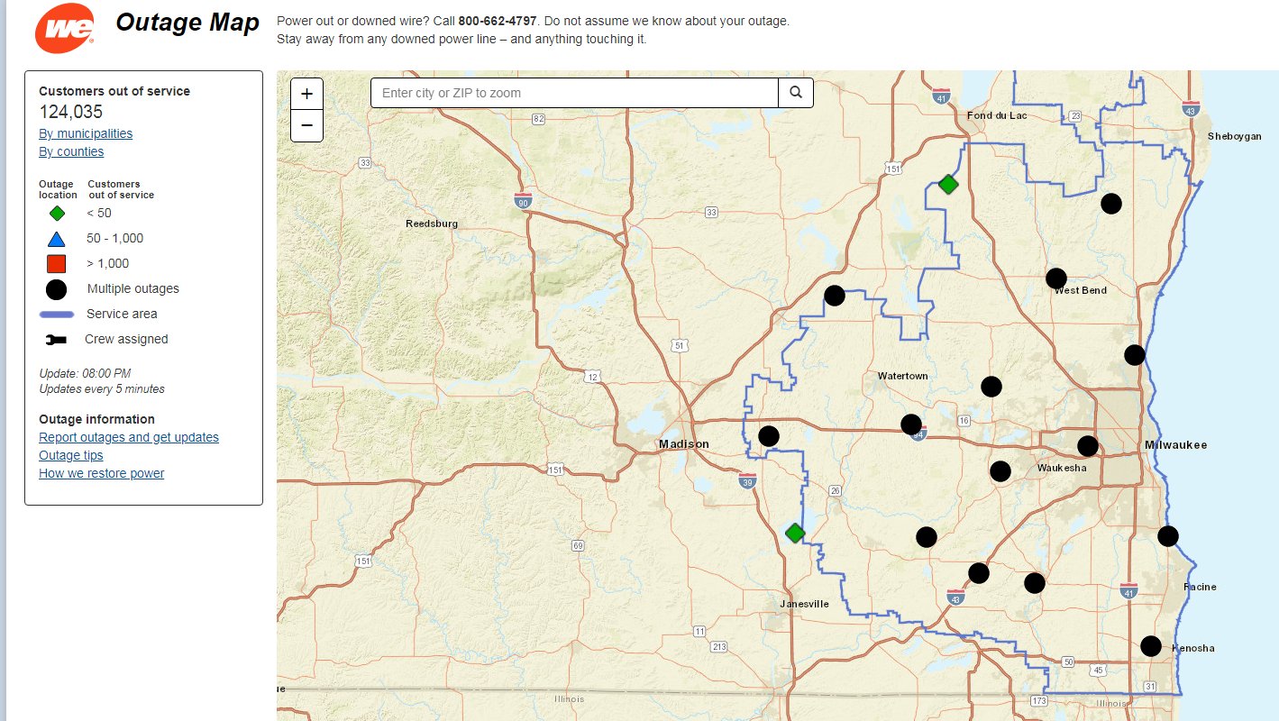 |
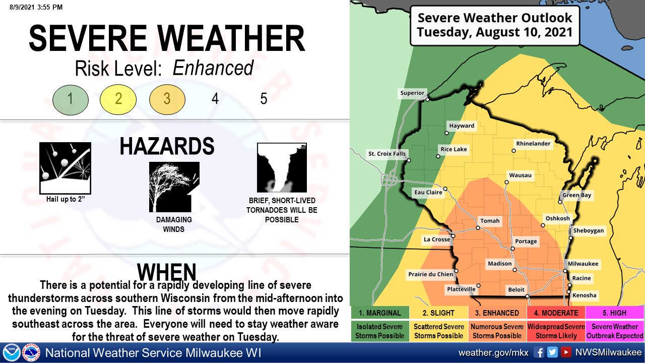
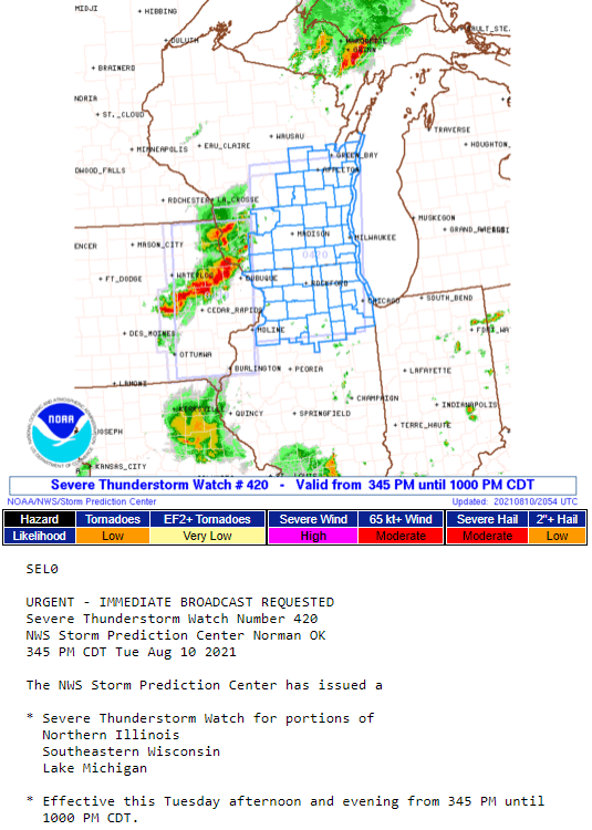
| NWS Highlighting the severe potential for Aug. 10th the day before. | Severe Thunderstorm Watch issued Tuesday afternoon. | Power Outage map from We Energies at 8 pm showing 124,000+ customers without power. More outages arrived later in the evening. |
Overview
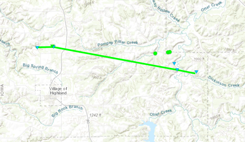
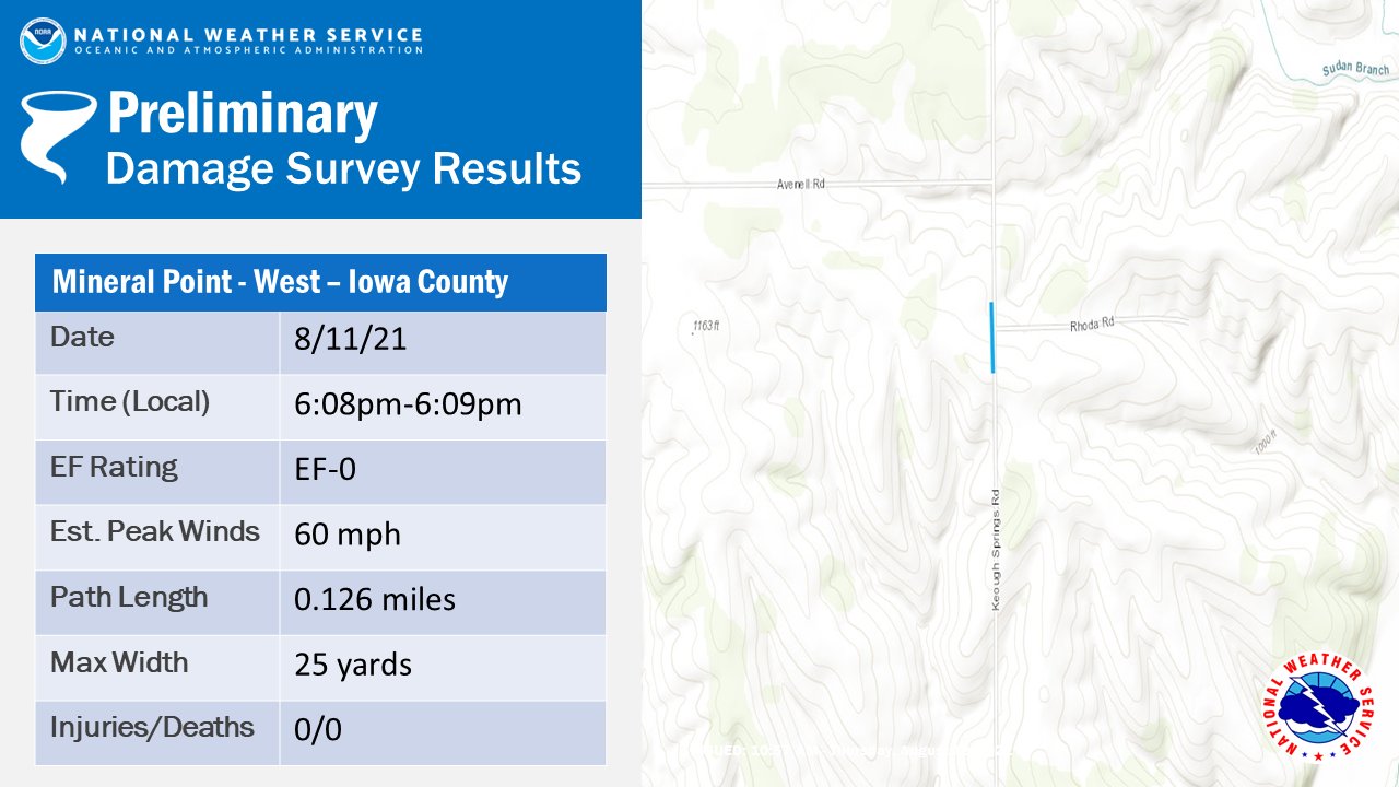
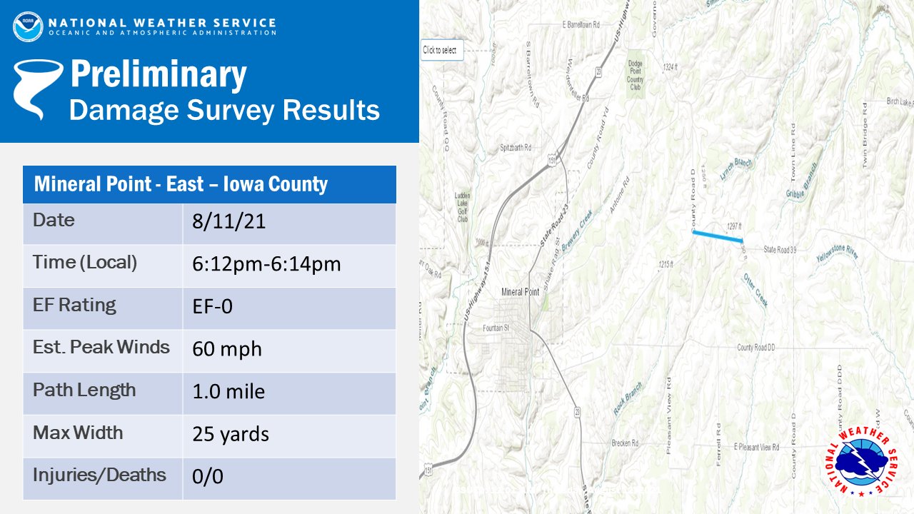
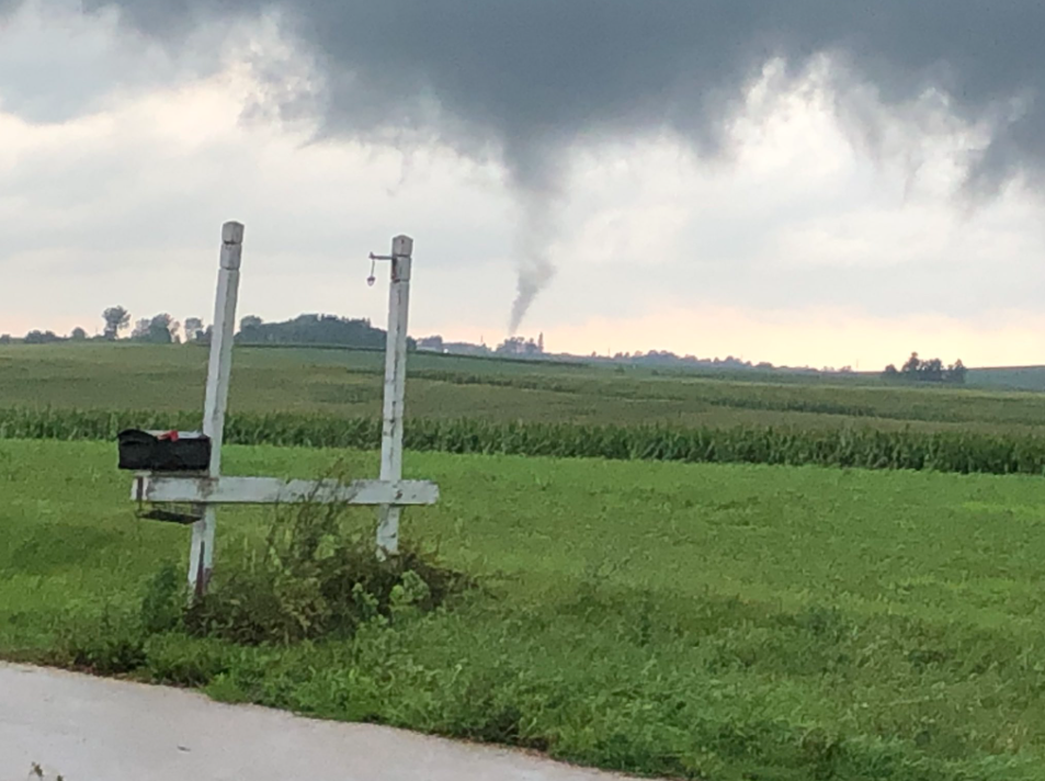
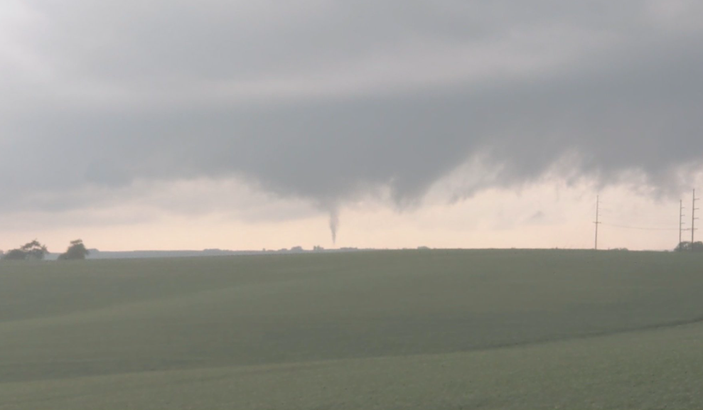
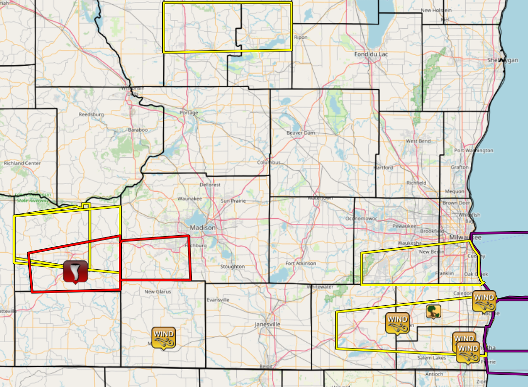
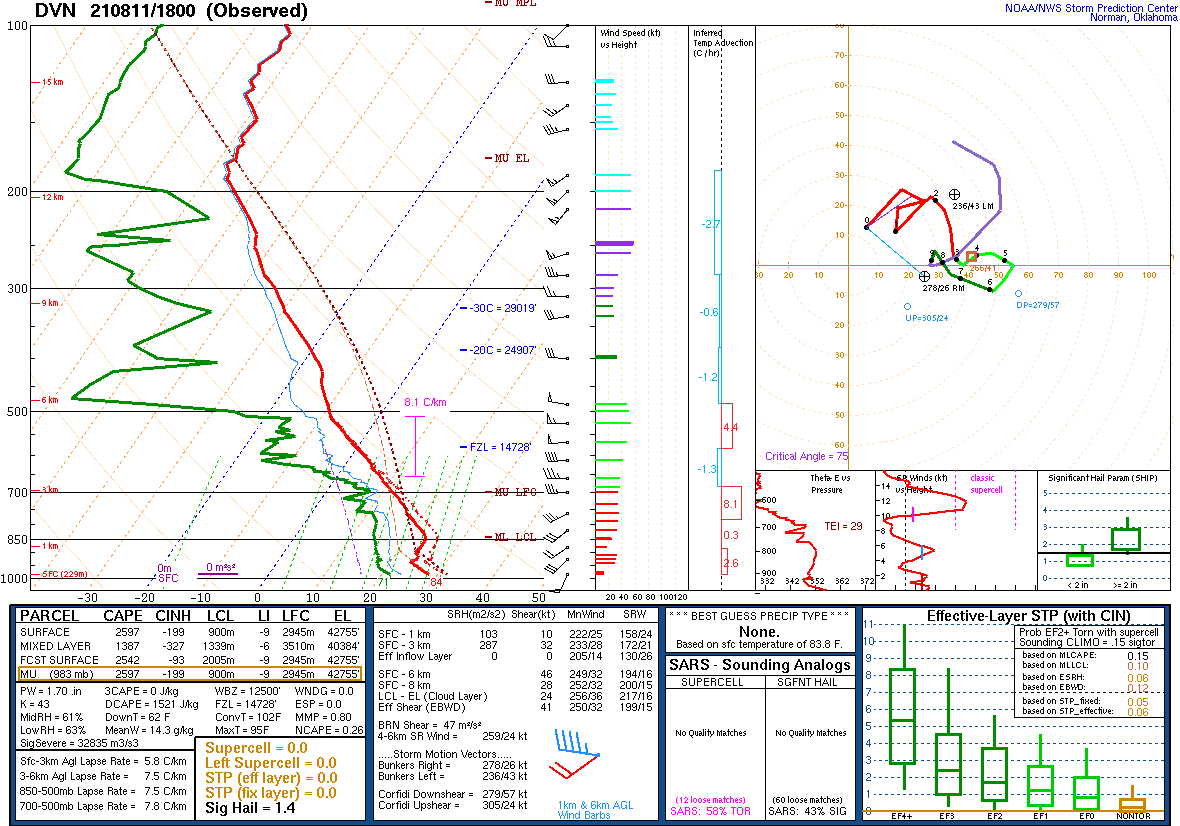
Supercell thunderstorms developed over western and southwestern Wisconsin in the afternoon on August 11th. These continued to move east into southern Wisconsin. One particular storm strengthened over western Iowa County producing two tornadoes. These were some of the most viewed tornadoes we've had in our area ever. Multiple storm chasers and storm spotters were on this storm capturing amazing video of the tornadoes as they moved through corn fields.
Tornadoes:
|
Tornado - Linden
|
||||||||||||||||
|
Tornado - Mineral Point
|
||||||||||||||||
The Enhanced Fujita (EF) Scale classifies tornadoes into the following categories:
| EF0 Weak 65-85 mph |
EF1 Moderate 86-110 mph |
EF2 Significant 111-135 mph |
EF3 Severe 136-165 mph |
EF4 Extreme 166-200 mph |
EF5 Catastrophic 200+ mph |
|
|||||
Radar
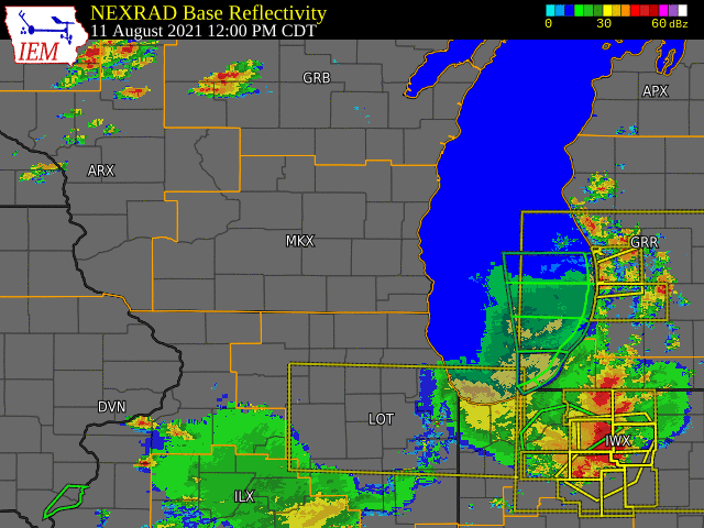 |
| Radar loop showing supercell thunderstorms forming over western Wisconsin and moving into southern Wisconsin. |
Photos & Video
Header
 |
 |
 |
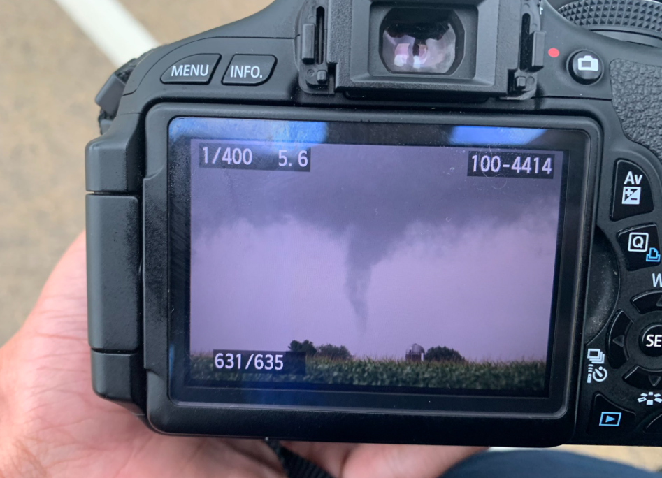 |
| Tornado Northwest of Walkwick near Highway 39 | Funnel Cloud near Cobb, WI | Tornado near Hollandale from Joey Marino | Tornado near Mineral Point from Ethan Mok |
Storm Reports
Header
 |
 |
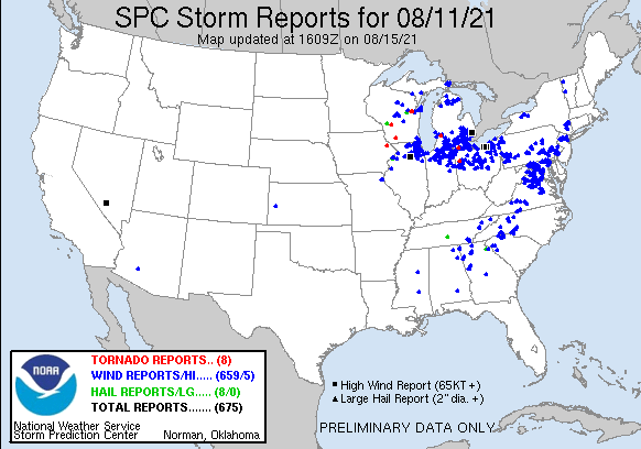
| SPC Storm Reports for Aug. 11th 2021 | Link to Map of storm reports |
								PRELIMINARY LOCAL STORM REPORT...SUMMARY
								NATIONAL WEATHER SERVICE MILWAUKEE/SULLIVAN WI
								915 PM CDT SUN AUG 15 2021

								..TIME...   ...EVENT...      ...CITY LOCATION...     ...LAT.LON...
								..DATE...   ....MAG....      ..COUNTY LOCATION..ST.. ...SOURCE....
								            ..REMARKS..

								0955 AM     TSTM WND GST     3 ENE MONROE            42.62N 89.60W
								08/11/2021  M37 MPH          GREEN              WI   AWOS

								            AWOS STATION KEFT MONROE.

								1035 AM     TSTM WND GST     3 N PLEASANT PRAIRIE    42.60N 87.93W
								08/11/2021  M58 MPH          KENOSHA            WI   ASOS

								            ASOS STATION KENW KENOSHA AIRPORT.

								1035 AM     TSTM WND GST     1 WNW BURLINGTON        42.68N 88.30W
								08/11/2021  M37 MPH          RACINE             WI   AWOS

								            AWOS STATION KBUU BURLINGTON.

								1045 AM     TSTM WND GST     1 ENE PLEASANT PRAIRIE  42.56N 87.91W
								08/11/2021  M53 MPH          KENOSHA            WI   MESONET

								            MESONET STATION FW3123 PLEASANT PRAIRIE.

								1058 AM     TSTM WND GST     2 W NORTH BAY           42.77N 87.82W
								08/11/2021  M44 MPH          RACINE             WI   ASOS

								            ASOS STATION KRAC RACINE-BATTEN AIRPORT.

								0615 PM     TORNADO          5 ENE MINERAL POINT     42.89N 90.09W
								08/11/2021                   IOWA               WI   TRAINED SPOTTER

								            SPOTTER CONFIRMED BRIEF TORNADO TOUCHDOWN
								            NEAR MINERAL POINT.

								0645 PM     TSTM WND DMG     2 NE EAGLE LAKE         42.73N 88.10W
								08/11/2021                   RACINE             WI   TRAINED SPOTTER

								            MULTIPLE TREES AND A POWER LINE DOWN.

								&&

								$$
Environment:
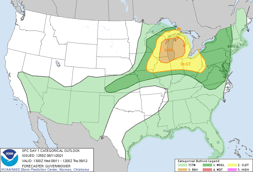 |
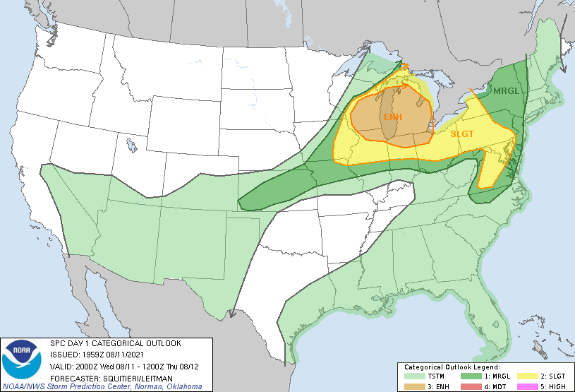 |
 |
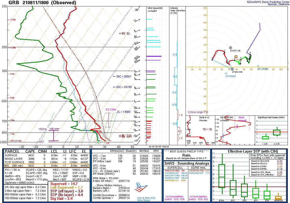 |
| SPC Day 1 Outlook 13 UTC | SPC Day 1 Outlook 20 UTC | DVN Sounding Early Afternoon Wednesday | GRB Sounding Early Afternoon Wednesday |
 |
Media use of NWS Web News Stories is encouraged! Please acknowledge the NWS as the source of any news information accessed from this site. |
|
Hazards
National Briefing
Hazardous Weather Outlook
Skywarn
View Local Storm Reports
Submit A Storm Report
Winter Weather
Summer Weather
Beach Hazards
Local Forecasts
Marine
Aviation
Fire
Local Text Products
Local Precip Forecast
Hourly Forecast Graphics
Forecast Discussion
Climate
Historic Events For Srn WI
Lightning Plot Archive
Daily Climate Graphics
Local Climate Products
Normals/Records MKE/MSN
CoCoRaHS
US Dept of Commerce
National Oceanic and Atmospheric Administration
National Weather Service
Milwaukee/Sullivan, WI
N3533 Hardscrabble Road
Dousman, WI 53118
262-965-2074
Comments? Questions? Please Contact Us.