
Wildfire smoke will push into the Midwest, worsening air quality. A frontal system brings severe storms from the Northern Plains to the Mid‑Atlantic the next few days. Heavy Gulf Coast rain is possible as Tropical Depression Two has formed, while monsoonal storms persist in the Southwest with heavy rainfall. Hazardous heat expands from the Plains into the Lower Mississippi Valley. Read More >
Strong thunderstorms moved across central into portions of southern Wisconsin on the evening of Tuesday June 2nd. The thunderstorms caused strong, damaging winds and sporadic damage from the Wisconsin Dells and Westfield east to Portage, Green Lake, Fond du Lac, Sheboygan, Beaver Dam, Hartford and Saukville. Weaker thunderstorms affected the remainder of southern Wisconsin during the late evening and overnight.
| Here is a radar animation beginning late Tuesday afternoon, continuing through most of Tuesday evening. | .gif) |
Wind Damage:
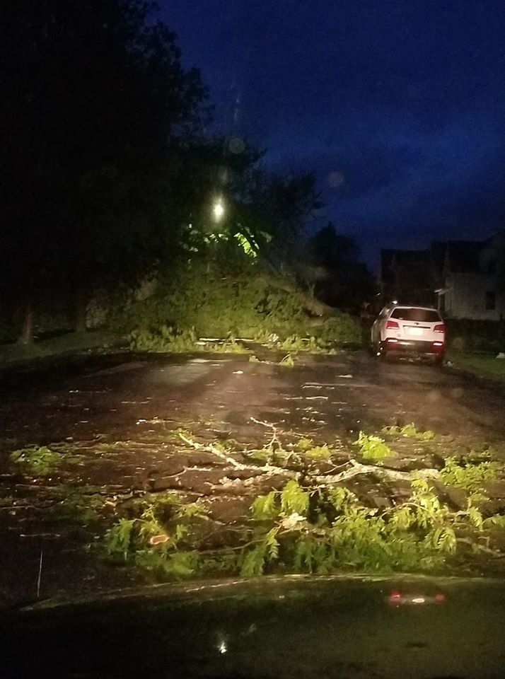
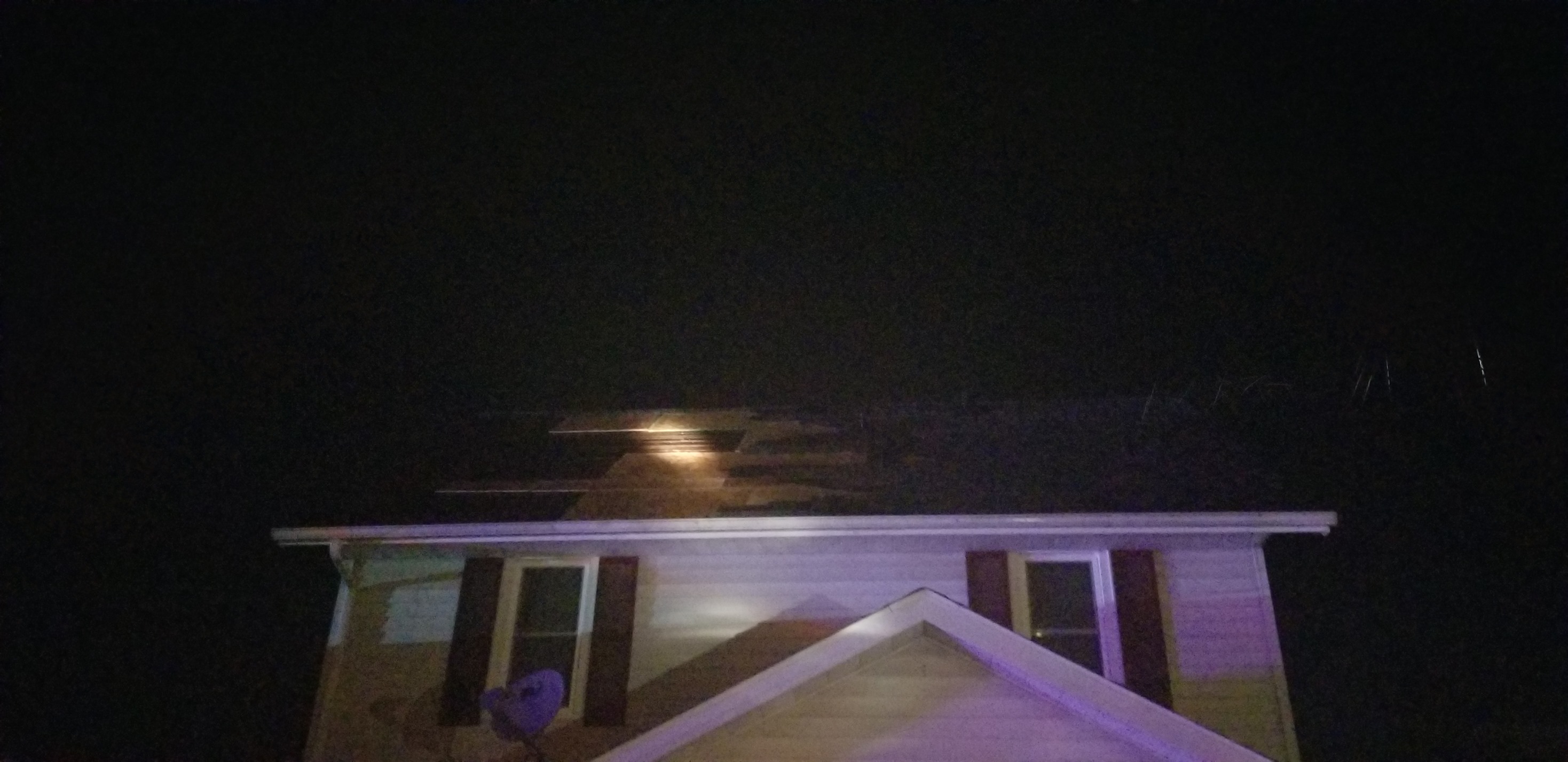
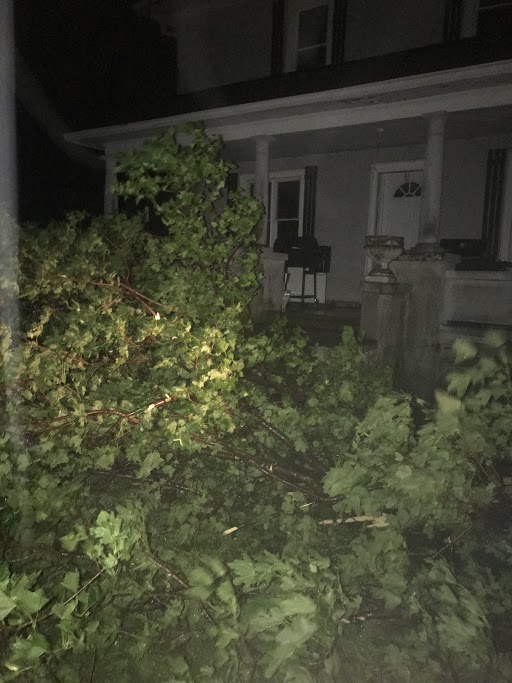
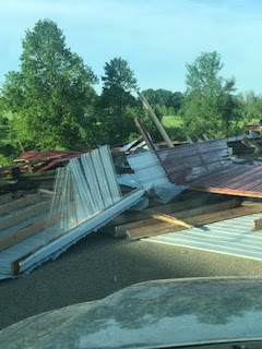
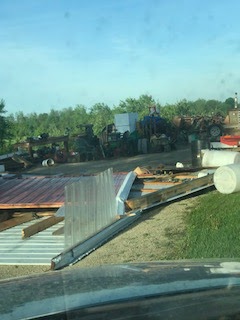
Here are several pictures of damage that occurred Tuesday evening due to the high winds produced by the thunderstorms. Peak wind gusts were in the 60 to 70 mph range.
 |
 |
 |
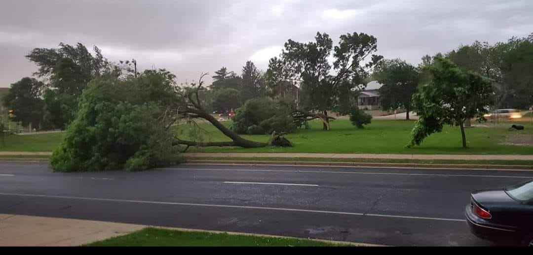 |
| Courtesy John Heitke | Courtesy: BJ DeMaa | Courtesy: WTMJ-TV | Courtesy: John Heitke |
 |
 |
 |
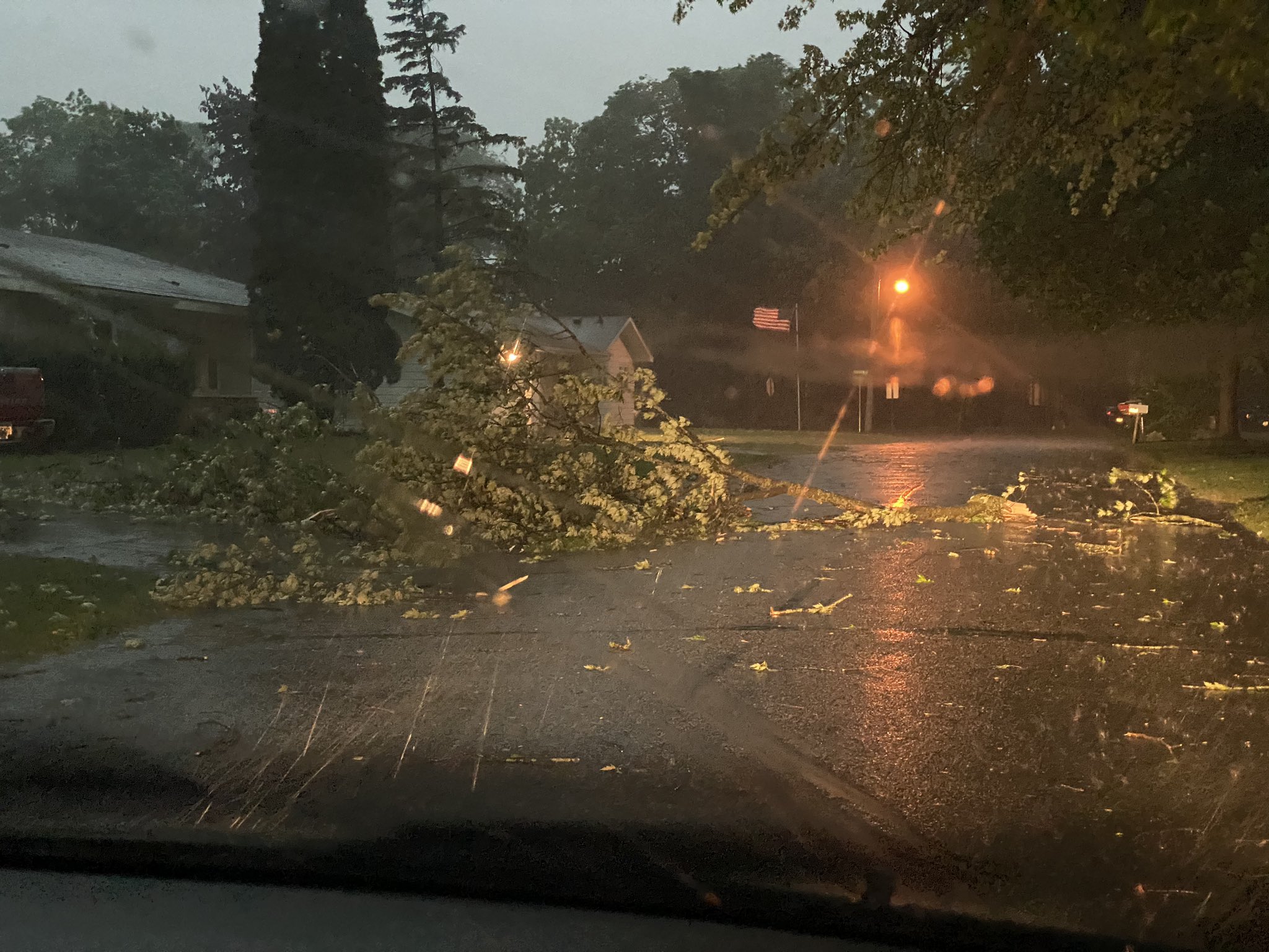 |
| Fond du Lac County | Fond du Lac County | Fond du Lac County | Pardeeville |
Storm Reports
PRELIMINARY LOCAL STORM REPORT...SUMMARY
NATIONAL WEATHER SERVICE MILWAUKEE/SULLIVAN WI
1038 AM CDT WED JUN 3 2020

..TIME...   ...EVENT...      ...CITY LOCATION...     ...LAT.LON...
..DATE...   ....MAG....      ..COUNTY LOCATION..ST.. ...SOURCE....
            ..REMARKS..

1040 PM     TSTM WND GST     6 SSE KENOSHA           42.50N 87.78W
06/02/2020  M41 MPH          LMZ646             WI   BUOY

            BUOY LOCATED OFF WINTHROP HARBOR AT THE
            WISCONSIN/ILLINOIS STATE LINE MEASURED
            STRONG WINDS AS THUNDERSTORMS ROLLED THROUGH
            DURING THE LATE EVENING.

0830 PM     TSTM WND DMG     JUNEAU                  43.41N 88.70W
06/02/2020                   DODGE              WI   PUBLIC

            TREE DAMAGE. TIME ESTIMATED FROM RADAR.

0830 PM     TSTM WND DMG     MOUNT CALVARY           43.83N 88.25W
06/02/2020                   FOND DU LAC        WI   EMERGENCY MNGR

            DOORS BLOWN OFF A BARN AND AN ATV THROWN 30
            FEET. AREAS OF A ROOF BLOWN OFF A HOUSE AND
            BARN. TIME ESTIMATED FROM RADAR.

0828 PM     TSTM WND DMG     2 ESE MAPLE BLUFF       43.10N 89.33W
06/02/2020                   DANE               WI   EMERGENCY MNGR

            SOME TREES AND POWER LINES DOWN ON THE NORTH
            AND EAST SIDES OF MADISON. TIME ESTIMATED
            FROM RADAR.

0825 PM     TSTM WND DMG     WAUPUN                  43.63N 88.74W
06/02/2020                   DODGE              WI   EMERGENCY MNGR

            LARGE NUMBER OF SHINGLES BLOWN OFF THE ROOF
            OF A HOME. WINDS ESTIMATED 60-70 MPH. TIME
            ESTIMATED FROM RADAR.

0820 PM     TSTM WND DMG     WAUPUN                  43.63N 88.74W
06/02/2020                   DODGE              WI   PUBLIC

            TREE DAMAGE. ROOF DAMAGE ON ONE HOUSE.

0820 PM     TSTM WND DMG     BLUE MOUNDS             43.02N 89.83W
06/02/2020                   DANE               WI   PUBLIC

            4 TO 6 INCH DIAMETER TREE LIMBS DOWN IN BLUE
            MOUNDS.

0803 PM     TSTM WND DMG     ARLINGTON               43.34N 89.38W
06/02/2020                   COLUMBIA           WI   EMERGENCY MNGR

            TREE DAMAGE. TIME ESTIMATED FROM RADAR.

0755 PM     TSTM WND DMG     4 ESE PORTAGE           43.52N 89.40W
06/02/2020                   COLUMBIA           WI   EMERGENCY MNGR

            LARGE 5TH WHEEL CAMPER TIPPED OVER. TREES
            DOWN. SHINGLES OFF ROOF. TIME ESTIMATED FROM
            RADAR.

0715 PM     TSTM WND DMG     1 W WESTFIELD           43.88N 89.52W
06/02/2020                   MARQUETTE          WI   PUBLIC

            SHE SHED WENT ROLLING DOWN THE DRIVEWAY.
            LOTS OF TREES AND BRANCHES DOWN. TIME
            ESTIMATED FROM RADAR.

0940 PM     TSTM WND GST     2 NNW SAINT FRANCIS     43.00N 87.88W
06/02/2020  M41 MPH          LMZ645             WI   PUBLIC

            36 KNOT GUST AT MLWW3 OBSERVATION SITE.

0930 PM     TSTM WND GST     1 ESE SHEBOYGAN         43.75N 87.69W
06/02/2020  M41 MPH          LMZ643             WI   C-MAN STATION

            36 KNOT GUST AT THE SHEBOYGAN C-MAN STATION.

0920 PM     TSTM WND GST     1 ENE PORT WASHINGTON   43.39N 87.86W
06/02/2020  M45 MPH          LMZ643             WI   C-MAN STATION

            39 KNOT GUST AT PORT WASHINGTON HARBOR
            PWAW3.

0913 PM     TSTM WND GST     2 NNE MENOMONEE FALLS   43.17N 88.11W
06/02/2020  E45 MPH          WAUKESHA           WI   BROADCAST MEDIA

            TREE LIMBS AND BRANCHES DOWN IN MENOMONEE
            FALLS. TIME ESTIMATED FROM RADAR.

0912 PM     TSTM WND DMG     1 ESE KOHLER            43.73N 87.76W
06/02/2020                   SHEBOYGAN          WI   BROADCAST MEDIA

            LARGE AMERICAN FLAG AT ACUITY INSURANCE
            BUILDING WAS TORN UP BY STRONG WINDS. TIME
            ESTIMATED FROM RADAR.

0912 PM     TSTM WND GST     3 NNW SHEBOYGAN FALLS   43.77N 87.85W
06/02/2020  M66 MPH          SHEBOYGAN          WI   ASOS

            SHEBOYGAN AIRPORT ASOS MEASUREMENT.

0908 PM     TSTM WND DMG     1 WNW SAUKVILLE         43.39N 87.97W
06/02/2020                   OZAUKEE            WI   EMERGENCY MNGR

            POWER POLE DOWN IN TOWN OF SAUKVILLE. TIME
            ESTIMATED FROM RADAR.

0856 PM     TSTM WND GST     2 SE MOUNT CALVARY      43.81N 88.22W
06/02/2020  M71 MPH          FOND DU LAC        WI   PUBLIC

            .

0855 PM     TSTM WND DMG     2 ESE HARTFORD          43.31N 88.34W
06/02/2020                   WASHINGTON         WI   AMATEUR RADIO

            LARGE TREES DOWN IN TOWN OF HARTFORD.

0852 PM     TSTM WND DMG     ERIN                    43.25N 88.37W
06/02/2020                   WASHINGTON         WI   PUBLIC

            TREES DOWN. TIME ESTIMATED FROM RADAR.

0838 PM     TSTM WND DMG     HUSTISFORD              43.35N 88.60W
06/02/2020                   DODGE              WI   BROADCAST MEDIA

            TREE AND POWER LINE DAMAGE, WITH A TREE ON
            FIRE. TIME ESTIMATED FROM RADAR.

0838 PM     TSTM WND GST     2 WSW FOND DU LAC       43.77N 88.49W
06/02/2020  M64 MPH          FOND DU LAC        WI   ASOS

            FOND DU LAC AIRPORT ASOS MEASUREMENT.

0830 PM     TSTM WND GST     1 SSE FOND DU LAC       43.77N 88.44W
06/02/2020  M60 MPH          FOND DU LAC        WI   TRAINED SPOTTER

            PENNY SIZE HAIL AS WELL.

0823 PM     TSTM WND GST     3 NE COLUMBUS           43.36N 88.99W
06/02/2020  M60 MPH          DODGE              WI   LAW ENFORCEMENT


0822 PM     TSTM WND DMG     BEAVER DAM              43.46N 88.84W
06/02/2020                   DODGE              WI   EMERGENCY MNGR

            NUMEROUS TREES AND POWER LINES DOWN IN
            BEAVER DAM. TIME ESTIMATED FROM RADAR.

0822 PM     TSTM WND DMG     FOND DU LAC             43.79N 88.45W
06/02/2020                   FOND DU LAC        WI   EMERGENCY MNGR

            SEVERAL REPORTS OF TRESS AND POWER LINES
            DOWN IN FOND DU LAC. TIME ESTIMATED FROM
            RADAR.

0800 PM     TSTM WND GST     PARDEEVILLE             43.53N 89.30W
06/02/2020  M65 MPH          COLUMBIA           WI   TRAINED SPOTTER

            60 TO 65 MPH GUSTS IN PARDEEVILLE.

0800 PM     TSTM WND DMG     6 SSW SPRING GREEN      43.10N 90.13W
06/02/2020                   IOWA               WI   EMERGENCY MNGR

            POWER LINES DOWN IN NORTHERN IOWA COUNTY.
            TIME ESTIMATED FROM RADAR.

0757 PM     TSTM WND DMG     PORTAGE                 43.54N 89.46W
06/02/2020                   COLUMBIA           WI   EMERGENCY MNGR

            A COUPLE OF STREET LIGHTS DAMAGED. A FEW
            TREES DOWN ON HOUSES. DAMAGE TO BILLBOARDS
            AND BIG SIGNS.

0755 PM     TSTM WND GST     KINGSTON                43.69N 89.13W
06/02/2020  M60 MPH          GREEN LAKE         WI   EMERGENCY MNGR

            .

0755 PM     TSTM WND GST     6 WNW SPRING GREEN      43.21N 90.19W
06/02/2020  M59 MPH          SAUK               WI   ASOS

            LONE ROCK AIRPORT ASOS MEASUREMENT.

0753 PM     TSTM WND DMG     4 E PORTAGE             43.55N 89.38W
06/02/2020                   COLUMBIA           WI   EMERGENCY MNGR

            TREE DOWN ON A HOUSE AND CAR. TIME ESTIMATED
            FROM RADAR.

0751 PM     TSTM WND DMG     4 ESE PORTAGE           43.52N 89.40W
06/02/2020                   COLUMBIA           WI   PUBLIC

            TREES DOWN ON SHED. SHED DESTROYED. TIME
            ESTIMATED FROM RADAR.

0751 PM     TSTM WND DMG     MARQUETTE               43.74N 89.14W
06/02/2020                   GREEN LAKE         WI   BROADCAST MEDIA

            2 FOOT DIAMETER TREES KNOCKED DOWN. BRANCHES
            BROKE AND BROKE OUT REAR WINDOW OF MINIVAN.
            TIME ESTIMATED FROM RADAR.

0749 PM     TSTM WND DMG     PORTAGE                 43.55N 89.47W
06/02/2020                   COLUMBIA           WI   TRAINED SPOTTER

            TREES DOWN, WITH SOME TREES AND BRANCHES
            DOWN ON CARS IN PORTAGE. ALSO TREES DOWN
            WITH SOME ROOF SHINGLE AND SHUTTER DAMAGE 1
            MILE SOUTH OF PORTAGE. TIME ESTIMATED FROM
            RADAR.

0745 PM     TSTM WND GST     7 NW PORTAGE            43.63N 89.56W
06/02/2020  M67 MPH          COLUMBIA           WI   MESONET


0742 PM     TSTM WND DMG     BARABOO                 43.47N 89.74W
06/02/2020                   SAUK               WI   911 CALL CENTER

            LOTS OF TREES AND POWER LINES DOWN
            THROUGHOUT SAUK COUNTY. TIME ESTIMATED FROM
            RADAR.

0740 PM     TSTM WND DMG     ENDEAVOR                43.71N 89.47W
06/02/2020                   MARQUETTE          WI   FIRE DEPT/RESCUE

            SIGNIFICANT AMOUNT OF TREES DOWN IN THE
            ENDEAVOR AREA. TIME ESTIMATED FROM RADAR.

0740 PM     TSTM WND GST     2 S ENDEAVOR            43.69N 89.47W
06/02/2020  M60 MPH          MARQUETTE          WI   TRAINED SPOTTER

            .

0736 PM     TSTM WND DMG     2 W LAKE DELTON         43.60N 89.82W
06/02/2020                   SAUK               WI   PUBLIC

            LARGE TREE LIMB DOWN.

0733 PM     TSTM WND DMG     WISCONSIN DELLS         43.62N 89.77W
06/02/2020                   COLUMBIA           WI   PUBLIC

            LARGE TREES DOWN. TIME ESTIMATED FROM RADAR.

0726 PM     TSTM WND DMG     1 WNW ENDEAVOR          43.72N 89.49W
06/02/2020                   MARQUETTE          WI   911 CALL CENTER

            TREES DOWN IN WESTERN PART OF MARQUETTE
            COUNTY. TIME ESTIMATED FROM RADAR.


&&

$$
 |
Media use of NWS Web News Stories is encouraged! Please acknowledge the NWS as the source of any news information accessed from this site. |
|

