April 2025 Climate Summaries
Mobile Alabama and Pensacola Florida Area
National Weather Service Mobile Alabama
May 1st, 2025
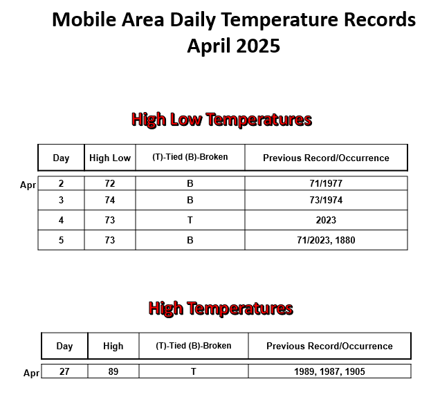
April 2025 in Review - The month started out with temperatures well above normal for nearly the first week with four successive mornings in Mobile reaching or breaking new record high low temperatures. During this period, lows averaged 15.3° above normal. At Pensacola lows averaged 13.3° above normal from the 1st to the 6th. A strong cold frontal passage during the early morning hours Monday April 7th sent temperatures below normal. The most notable lengthy duration of well below normal temperatures was in the lows from the 7th to 17th when lows averaged 7.6° below normal at Mobile and 6.4° below normal at Pensacola for the period. Following, temperatures rebounded to at or above normal to close out the month. In addition to the record setting April warmth at Mobile to start the month, a record high was reached at the end of the month. No record temperatures were reached at Pensacola.
April rainfall for the month was nearly non-existent at Mobile and Pensacola with only three days seeing measurable precipitation at both sites. Despite this, a slow eastward translating front over the deep south on Sunday the 6th, brought record setting one day rainfall when over a half foot of rain filled the rain gauge at Mobile in which the monthly average rainfall was exceeded that day too. Pensacola was not as fortunate, with only a little over an inch of rain measured for the month resulting in a deficit of several inches short of the April average there.
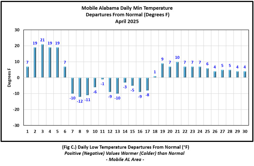
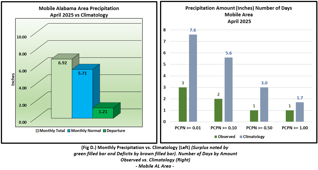
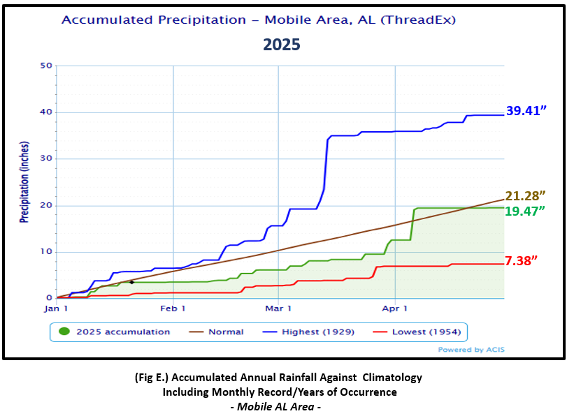
Mobile Alabama Area [Climate Normal Period 1991-2020, Climate Record Period 1872 to Present]- The average monthly high of 80.6° was 2.8° above normal. The average monthly low was 58.8° or 2.8° above normal. The average monthly temperature of 69.7° was 2.8° above normal. The highest temperature for the month, 89° on the 27th, was 9° above the normal daily high temperature for this date and also tied a record high for the date. Mobile also saw four consecutive mornings on the 2nd, 3rd, 4th and 5th resulting in new record high low temperatures. For more details on Mobile's record temperatures, please see the link April 2025 Record Temperatures for Mobile AL. The lowest temperature for the month, a chilly 42° on the morning of the 8th was 12° below the normal daily low temperature on this date. (Fig. A) shows a graphical representation of how the Mobile area temperatures compared to the seasonal normal daily highs and lows, which are shown by the colored dashed lines. Bar graphs reflecting the daily high/low temperature departures from normal are provided in the table below (Figs. B and C). Sunday April 6th, the daily rainfall swelled to over a half foot at 6.51", setting a new daily record excessive rainfall. The previous record for the date was 3.65" set way back in 1918. Monthly total rain added up to 6.92"or 1.21" above normal (Fig. D). Despite the rainfall surplus against the means for the month, annual rainfall (Fig. E) is in deficit territory, 1.17" below normal to date.
April top records for the month during the Period of Record for the Mobile Area:
Click on the Mobile Alabama area climate graphics below to expand:

|

|
|
|
|
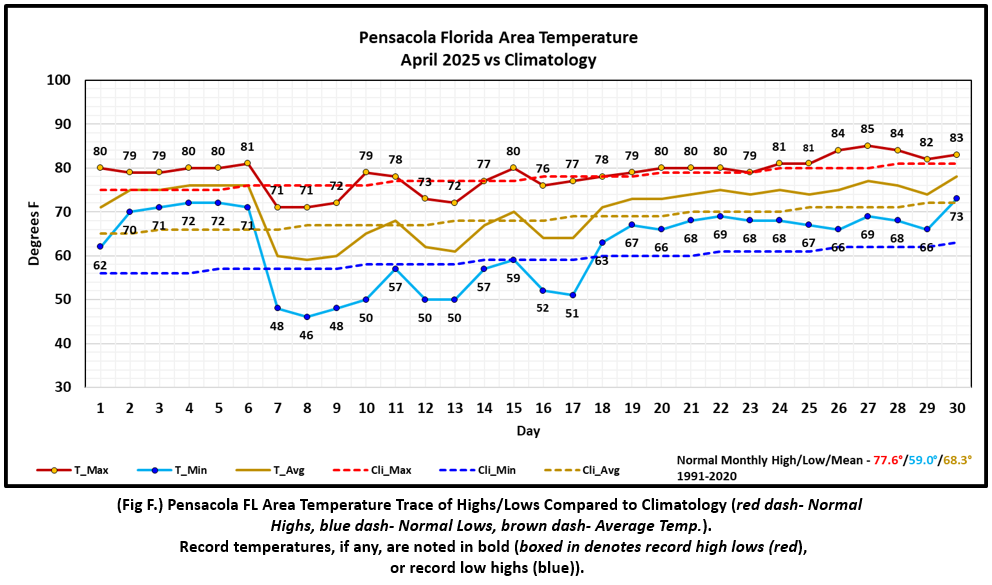
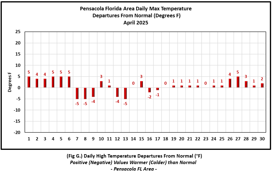
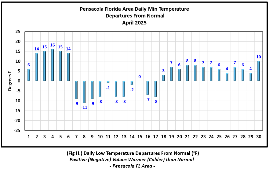
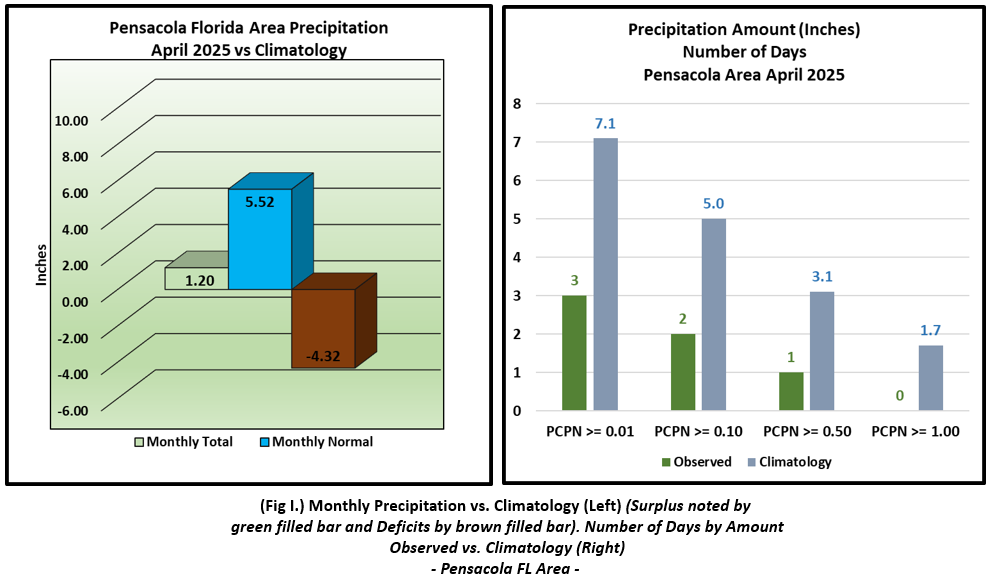
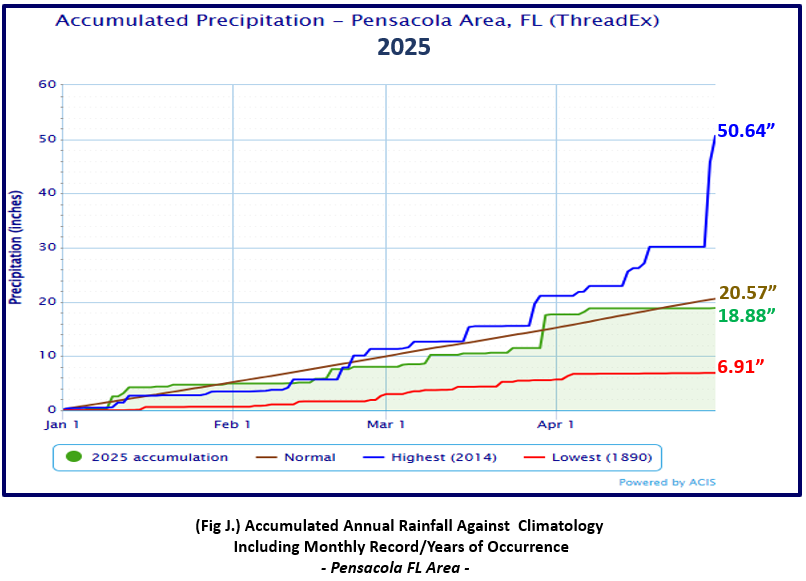
Pensacola Florida Area [Climate Normal Period 1991-2020, Climate Record Period 1879 to Present] - The average monthly high of 78.7° was 1.1° above normal. The average monthly low was 62.1° or 3.1° above normal. The average monthly temperature of 70.4° was 2.1° above normal. The highest temperature for the month, 85°, was reached on the 27th and 5° above the normal daily high for the date. The lowest temperature for the month of 46° occurred on the morning of the 8th and 11° below the normal daily low temperature for the date. No record temperatures were reached at Pensacola. (Fig. F) shows a graphical representation of how the Pensacola area temperatures compared to the seasonal normal daily highs and lows, which are shown by the colored dashed lines. (Figs. G and H) shows the daily high/low temperature departures from normal. Not much rain. The rain gauge measured 1.20", 4.32" below normal for April (Fig. I). Pensacola's year to date rainfall is in deficit (Fig. J) by 1.18" below normal.
April top records for the month during the Period of Record for the Pensacola Area:
Click on the Pensacola Florida area climate graphics below to expand:
|
|
|
|
|
Additional April 2025 Climatology and Topics
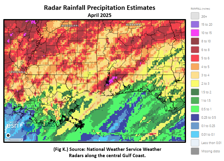
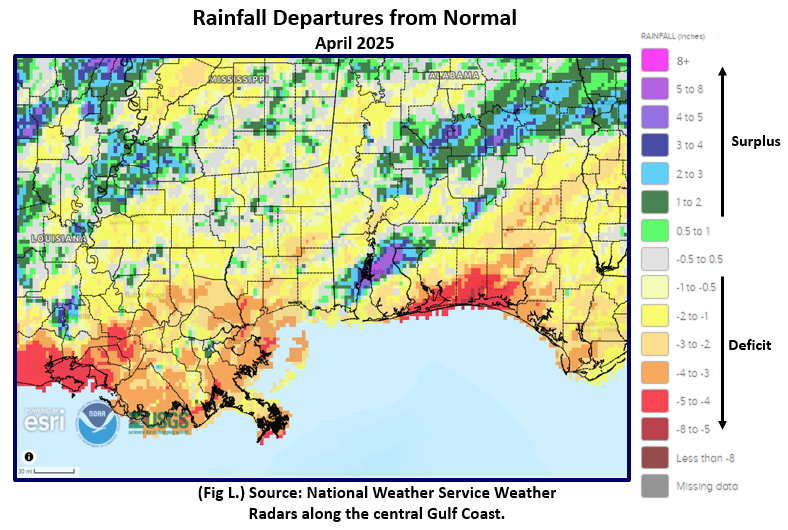
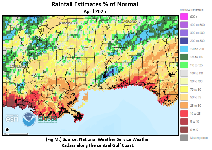
The central Gulf coast saw pockets of above normal rainfall. The most significant and impactful short-duration rainfall occurred from central Mobile Co., northeast to central Baldwin Co. AL to across northern Escambia Co. FL. These rains resulted in flash flood emergencies, high water rescues, impassable roads and a sharp river flooding response on April 6th. For details on the event, refer to the link April 6th Excessive Rainfall. Fig. K shows the areal monthly rainfall total, Fig. L shows the areal rainfall departures from normal and Fig. M, the areal percent of normal rainfall.
The latest April 2025 Monthly Climate Summary for Eglin Air Force Base (KVPS) and Duke Field (KEGI) has been provided courtesy of Mr. David Biggar, Staff Meteorologist, 96th Weather Squadron. Provided by permission.
|
|
|
May 2025 Climatology, Seasonal Climatology and Outlooks:
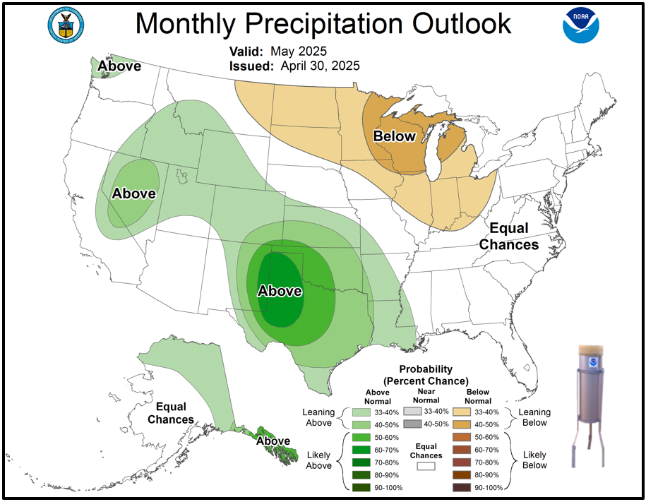
The outlook for May calls for temperatures to lean above normal from the northern tier of the country, east and south from the Northeast to the Gulf coast. Equal chances of above or below normal precipitation is favored from the central Gulf coast to the Southeast US. The month of May also signals that the start of the Atlantic Basin Hurricane Season is knocking at the door. Be on the lookout for NOAA's official hurricane season outlook, coming by the middle of May.
Click on the snap shots below to expand:
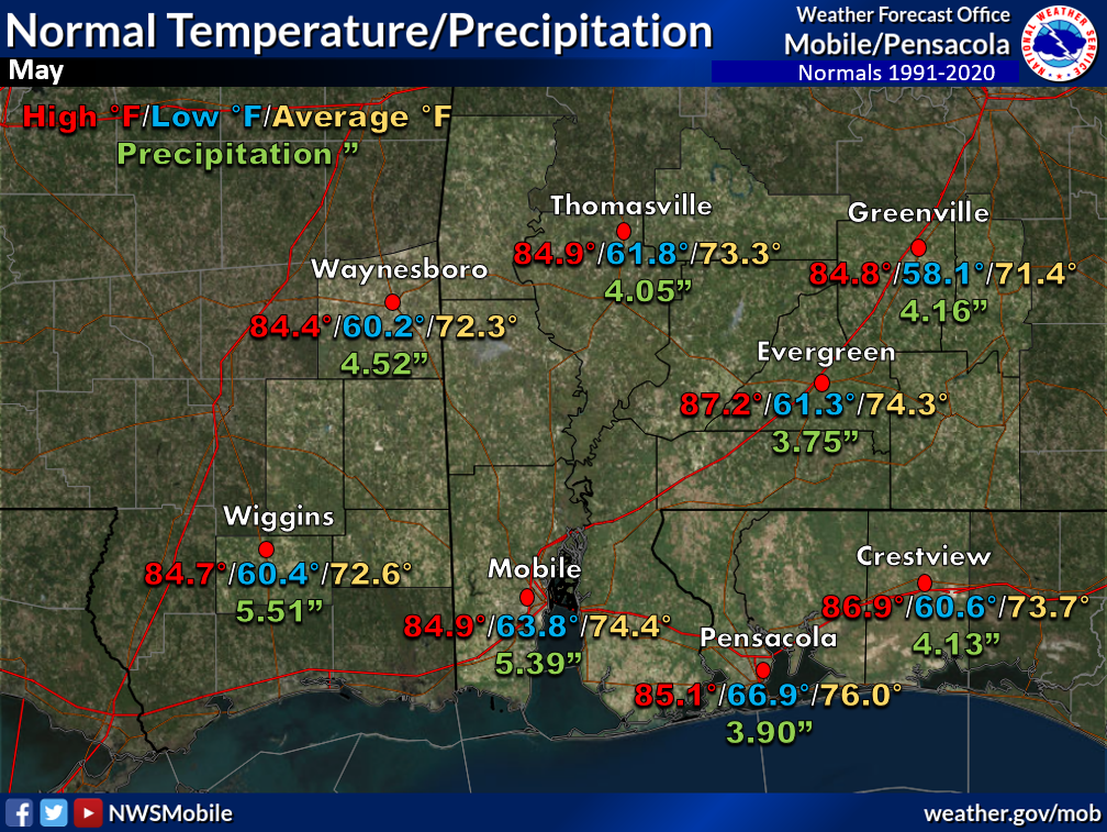 May Normals May Normals |

|
Outlook |

|
Additional Climate Links:
The National Weather Service Mobile Alabama's Climate and Past Weather page provides climate data at your fingertips for many observation points in the local forecast area by accessing the NOWData tab as well as many other climate resources. The Climate Prediction Center Link provides short and longer range climatic outlooks and education about the larger scale global circulations that impact temperatures and weather. With the large agriculture and farming presence along the central Gulf coast, the Drought Monitor link provides updates on drought trends and impacts. Another very helpful resource is the Community Collaborative Rain Hail and Snow (CoCoRaHS) network, which is a large group of volunteers working together to measure and map precipitation (rain, hail, and snow). The aim of CoCoRaHS is to provide the highest quality data for natural resource, education and research applications. You can be a part of the CoCoRaHS team by becoming a volunteer rainfall observer.


