September 2023 Climate Summaries
Mobile Alabama and Pensacola Florida Area
National Weather Service Mobile Alabama
October 3, 2023
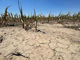
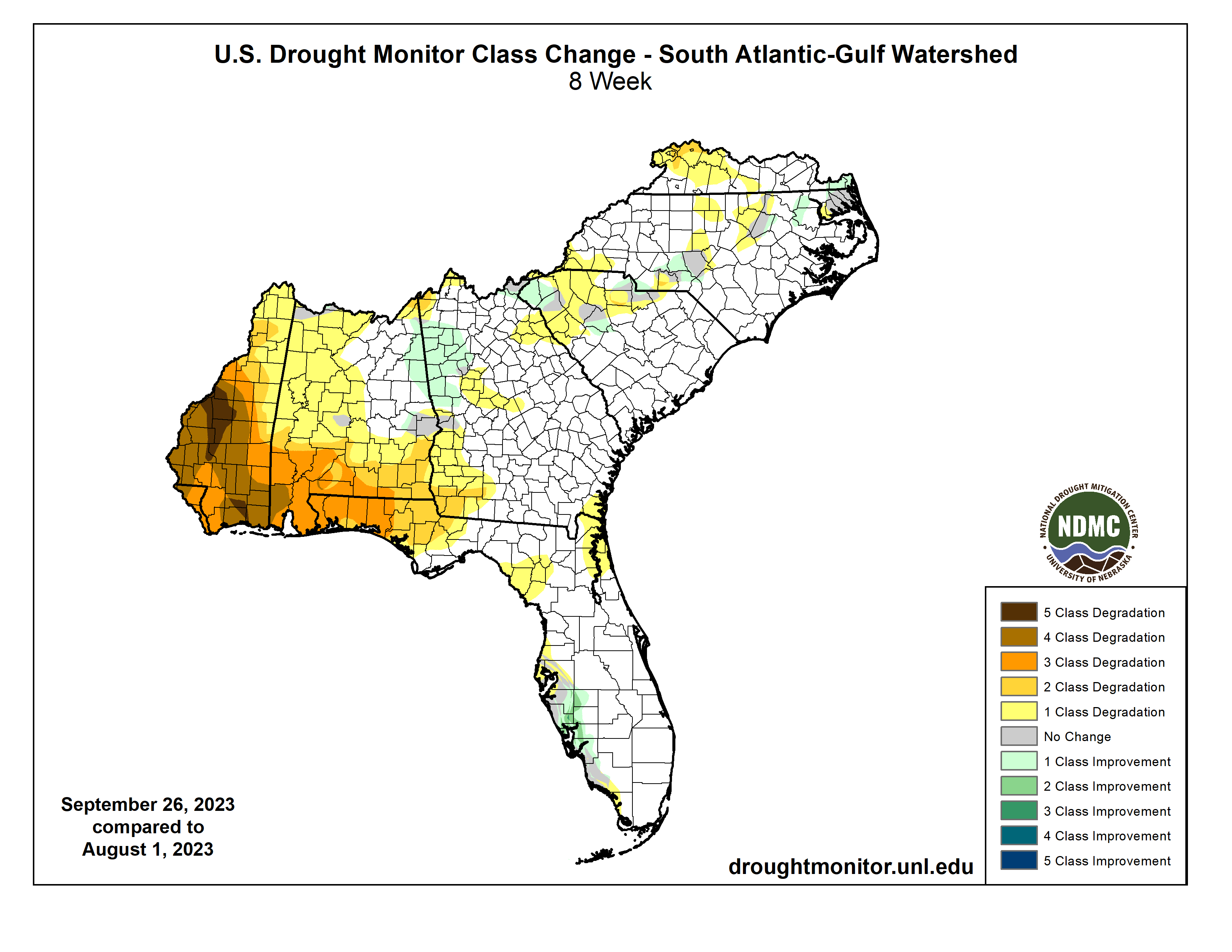
September 2023 in Review - Average temperatures settled closer to normal by one to three degrees on average above the pace against the climatological means. High temperatures averaged highest near 5° above normal at Mobile. Mobile also saw the only record temperatures for the month, two record highs and one record high low. With that said, September 2023 was a completely different story than what appeared to be a common occurrence of record daily temperatures back in August. The big story for the central Gulf coast has been a lack of rainfall resulting in an extended period of high intensity drought that started in August and continued into the month of September. During the recent two month span, drought worsened by a three to four class degradation over the central Gulf coast. September's total precipitation at both Mobile and Pensacola was shy of normal by over three inches. At the close of September, the largest annual rainfall deficit is at Mobile coming in at over 8" below normal to date.
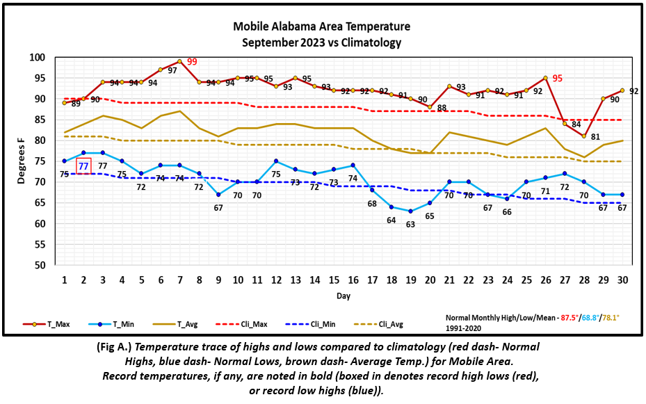
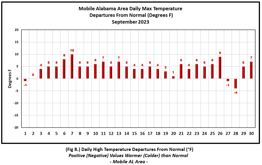
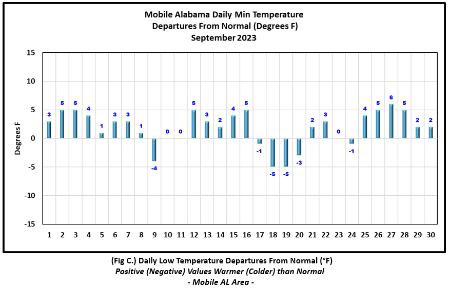
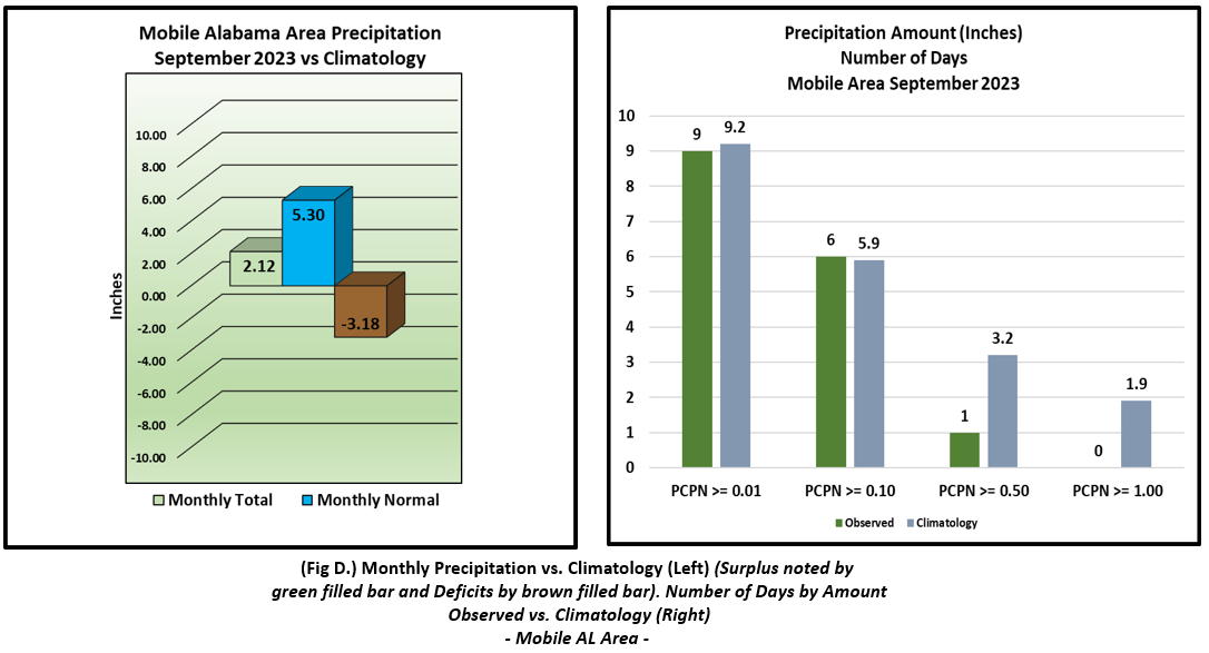
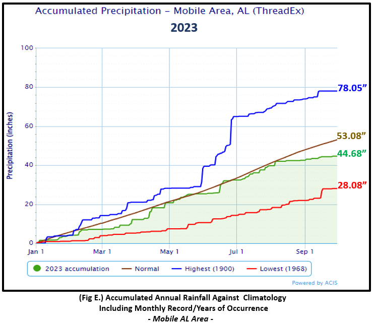
Mobile Alabama Area [Climate Normal Period 1991-2020, Climate Record Period 1872 to Present]- The average monthly high of 92.1° was 4.6° above normal. The average monthly low was 70.7° or 1.9° above normal. The average monthly temperature of 81.4° was 3.3° above normal. The highest temperature for the month was 99° on the 7th or 10° above the normal for the date. This also set a new record high, surpassing the previous record of 97° set on that date in 2019. The other record high was 96° on the 26th, which tied the previous occurrence set on this date also in 2019. The lowest temperature for the month was a cool 63° on the 19th, 5.0° below normal for this date. A record high low temperature of 77° on the morning of the 2nd tied the previous occurrences set in 1947, 1943, 1937, 1918, 1907, 1906, and 1880.(Fig. A) shows a graphical representation of how the Mobile area temperatures compared to the seasonal normal daily highs and lows, which are shown by the colored dashed lines. Bar graphs reflecting the daily high/low temperature departures from normal are provided in the table below (Figs. B and C). Rain was lacking, with the rain gauge only measuring 2.12" (Fig. D), 3.18" below the monthly normal. Annual rainfall deficits have increased to near 8.5" (Fig. E)
September top records for the month during the Period of Record for the Mobile Area:
Click on the Mobile Alabama area climate graphics below to expand:
|
|
|
|
|
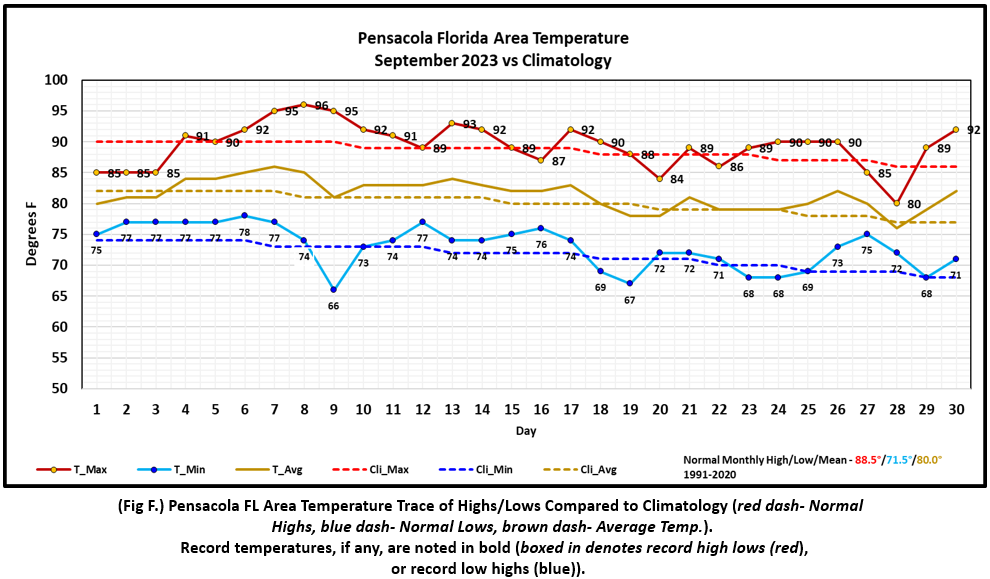
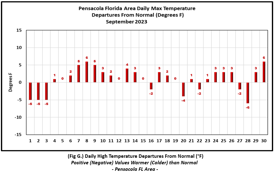
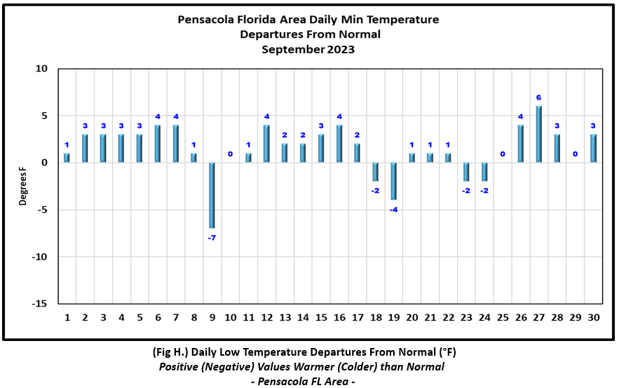
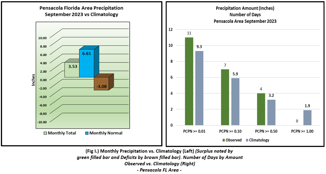
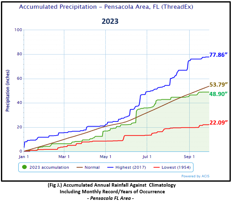
Pensacola Florida Area [Climate Normal Period 1991-2020, Climate Record Period 1879 to Present] - The average monthly high of 89.4° was 0.9° above normal. The average monthly low was 73.0° or 1.5° above normal. The average monthly temperature of 81.2° was 1.2° above normal. The highest temperature for the month, 96° on the 8th, was 6° above the normal daily high temperature. The lowest temperature for the month, 66° on the 9th, was 7° below the normal daily low temperature for this date. No record temperatures were set at Pensacola. (Fig. F) shows a graphical representation of how the Pensacola area temperatures compared to the seasonal normal daily highs and lows, which are shown by the colored dashed lines. (Figs. G and H) shows the daily high/low temperature departures from normal. A little more rain occurred in Pensacola with a gauge catch at 3.53" (Fig. I), but still below the monthly normal of 3.08". Annual rainfall deficits are just shy of 5" (Fig. J).
September top records for the month during the Period of Record for the Pensacola Area:
Click on the Pensacola Florida area climate graphics below to expand:
|
|
|
|
|
Additional September 2023 Climatology and Topics
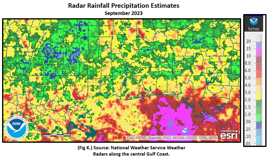
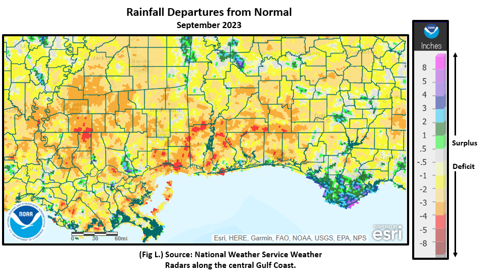
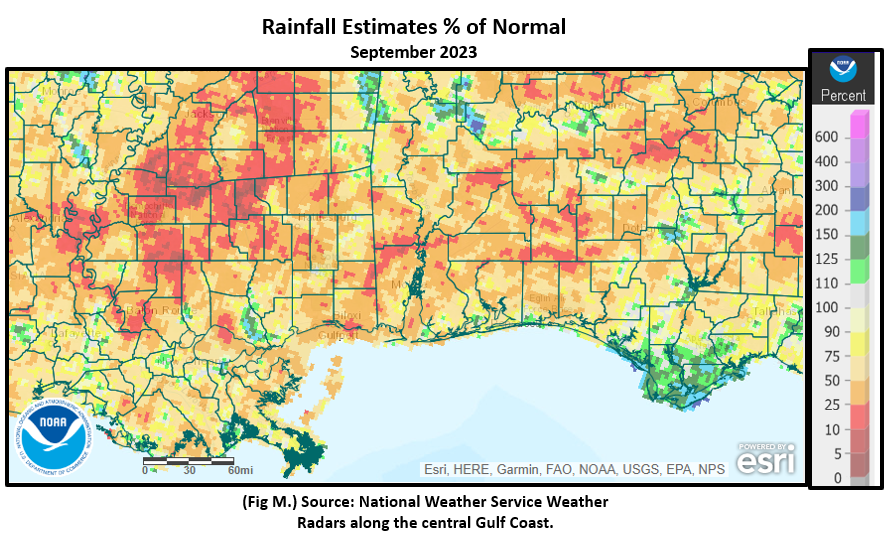
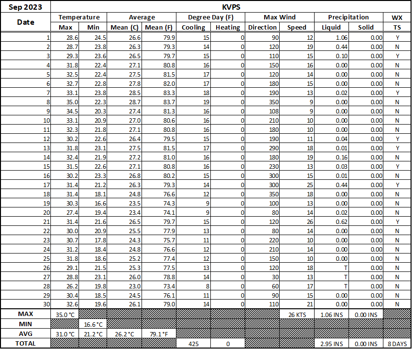
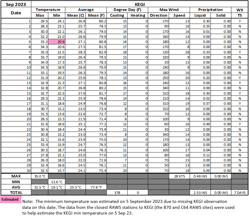
The central Gulf coast is parched with the local area being impacted by high intensity drought. Much of the central Gulf coast saw monthly rainfall ranging 2 to 5 inches below normal or 10 to 50% of normal. The driest locations were along and southeast of the I-65 corridor and westward over the southern half of Mississippi. Fig.K shows the areal monthly rainfall total, Fig. L shows the areal rainfall departures from normal and Fig. M, the areal percent of normal rainfall. The September 2023 monthly summary for Eglin Air Force Base (AFB) - KVPS and Duke Field - KEGI has also been received and provided in the table below. The temperatures in the daily tables consists of numbers both in °F/°C. Data courtesy of Mr. David Biggar, Staff Meteorologist, 96th Weather Squadron. Provided by permission.
|
|
|
|
|
|
October 2023 Climatology, Seasonal Climatology and Outlooks:
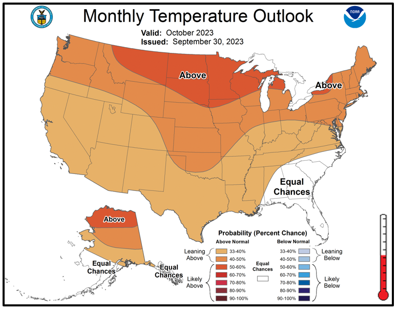
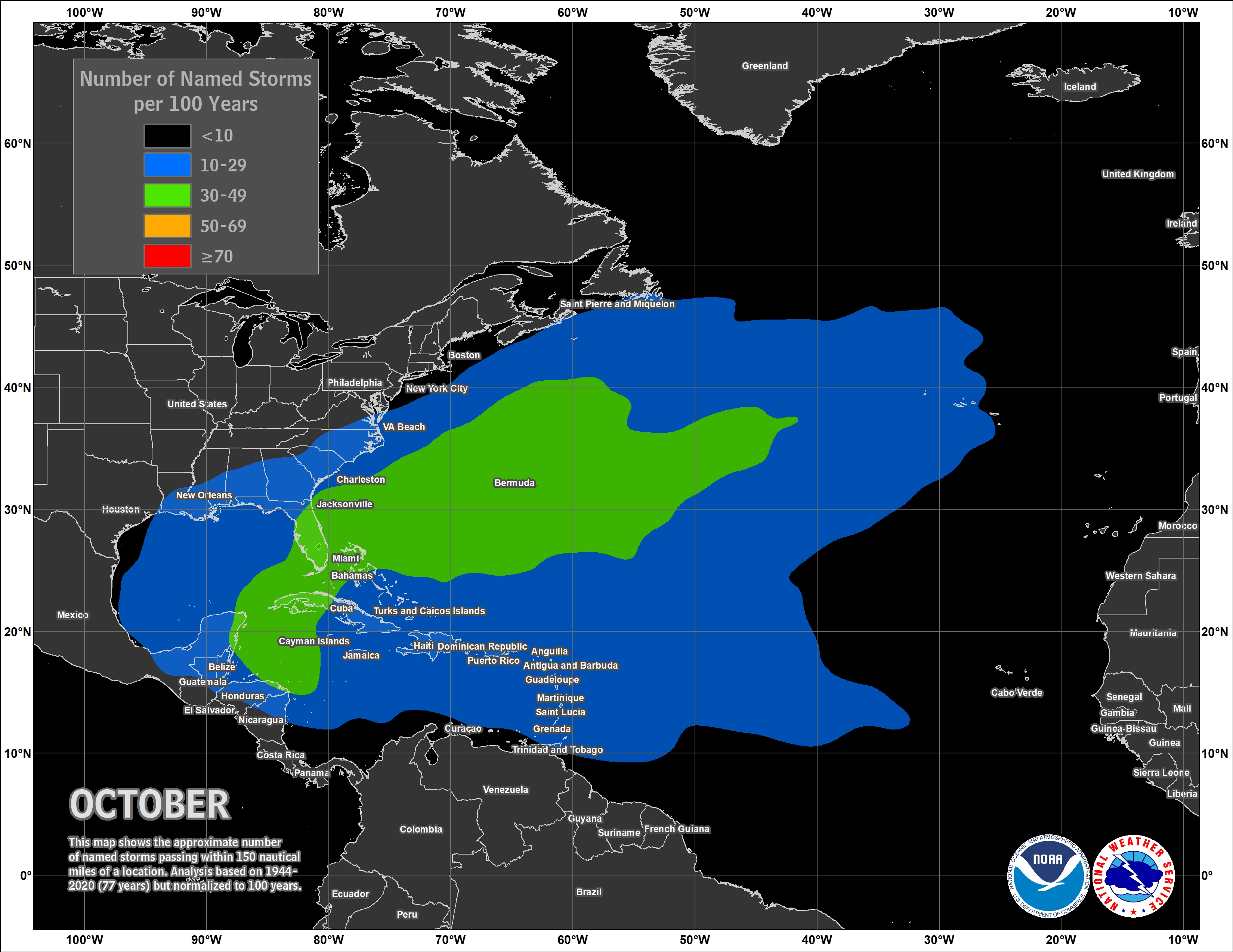
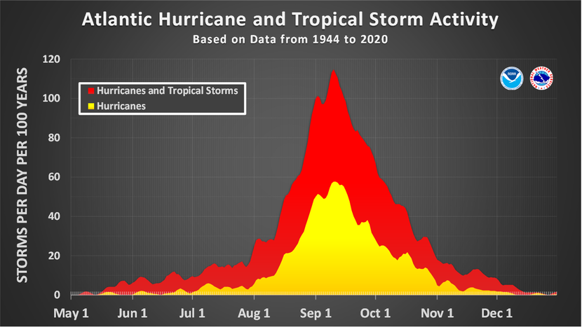
Looking ahead to October, there appears to be equal chances of above or below normal temperatures over the southeast US while remainder of the country is favored to see above normal warmth. The outlook for much needed rain is not a promising one. Drought, at least in the shorter term, appears to maintain its hold on the deep south into the month of October. Some promise of wetter conditions may set up during the close of 2023, but the question looms on how much of an impact this will have on drought. For more detailed information on weekly drought and outlooks, see the latest drought statements. Although we have moved out of the climatological peak of hurricane season, take note that October does see a climatological spike in tropical cyclone occurrences with the points of origin typically from the northwest Caribbean, Gulf and off the southeast US coast.
Click on the snap shots below to expand:
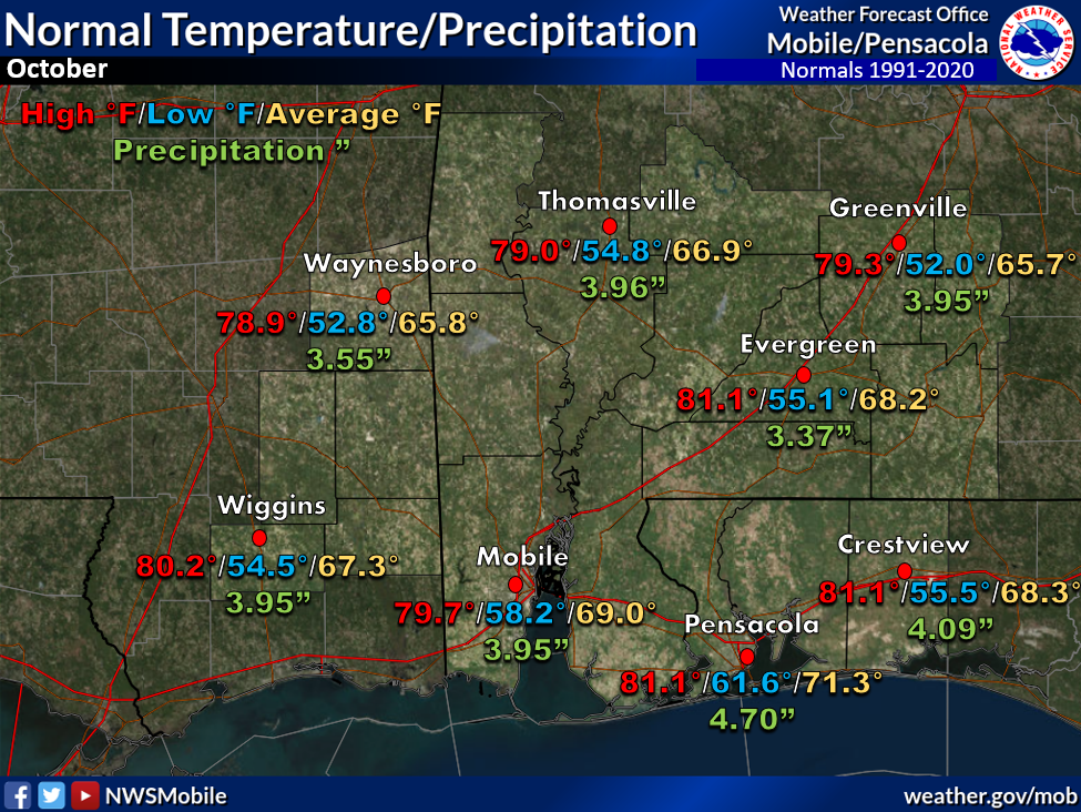 October Normals October Normals |
|
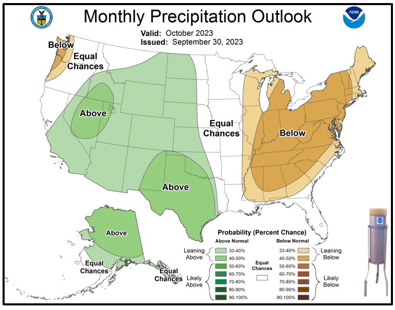
Outlook |

|
|

|
|
|

|
Additional Climate Links:
The National Weather Service Mobile Alabama's Climate and Past Weather page provides climate data at your fingertips for many observation points in the local forecast area by accessing the NOWData tab as well as many other climate resources. The Climate Prediction Center Link provides short and longer range climatic outlooks and education about the larger scale global circulations that impact temperatures and weather. With the large agriculture and farming presence along the central Gulf coast, the Drought Monitor link provides updates on drought trends and impacts. Another very helpful resource is the Community Collaborative Rain Hail and Snow (CoCoRaHS) network, which is a large group of volunteers working together to measure and map precipitation (rain, hail and snow). The aim of CoCoRaHS is to provide the highest quality data for natural resource, education and research applications. You can be a part of the CoCoRaHS team by becoming a volunteer rainfall observer.


