
Dangerous heat will expand from the Gulf Coast into the Southern Plains and Desert Southwest through week's end. Additional extreme heat impacting the Pacific Northwest will shift to the northern Plains by the weekend. Tropical Storm Bertha is expected to continue to impact portions of the northern Gulf Coast from the western Florida Panhandle to southeastern Louisiana through tonight. Read More >
Omaha/Valley, NE
Weather Forecast Office
A storm system brought snow to parts of the area on Easter Sunday, April 1st. Some locations in southeast Nebraska received 6 to 10" of snow, while other parts of the local area received no snow at all. The snow set up in a very narrow band that was only about 10 to 25 miles wide.
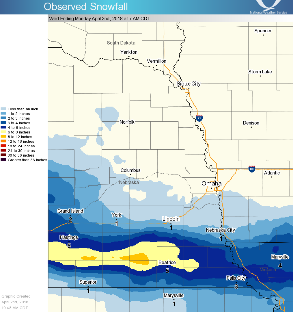
Here are some notable snowfall totals:
Crete, NE 10"
Tobias, NE 9"
Daykin, NE 6.7"
Auburn, NE 6.2"
Tecumseh, NE 6.0"
Table Rock, NE 6.0"
Adams, NE 5.5"
Falls City, NE 5.5"
Fairbury, NE 5.5"
Hickman, NE 5.0"
Wilber, NE 5.0"
Beatrice, NE 4.7"
Virginia, NE 4.0"
Salem, NE 4.0"
Verdon, NE 4.0"
Shubert, NE 4.0"
Clarinda, IA 1.5"
Malcom, NE 1.1"
Sidney, IA 1.1"
Lincoln, NE (airport) 0.8"
Seward, NE 0.5"
Omaha, NE (airport) 0
Warnings/Hazards
Forecast Discussion
Winter Weather
Severe Weather
Fire Weather
Drought
Storm Prediction Center
SubmitReport
Rivers And Lakes
River Forecasts
Missouri River Overview
Platte River Overview
Elkhorn River Overview
Ice Jam Risk
Local Information
Latest Briefing Packet
Weather Monitor
Winter Monitor
Preparedness
Storm Spotters
About Us
Other Useful Links
US Dept of Commerce
National Oceanic and Atmospheric Administration
National Weather Service
Omaha/Valley, NE
6707 North 288th Street
Valley, NE 68064-9443
402-359-5166
Comments? Questions? Please Contact Us.

