
A heat wave over the Southwest will intensify this week, peaking and expanding into the Intermountain West and northern High Plains this weekend. Severe thunderstorms and heavy rainfall are expected over parts of the Upper Midwest to mid-Mississippi Valley today. Critical to extremely critical fire weather conditions from the Northwest and the northern Great Basin on Saturday and Sunday. Read More >
Omaha/Valley, NE
Weather Forecast Office
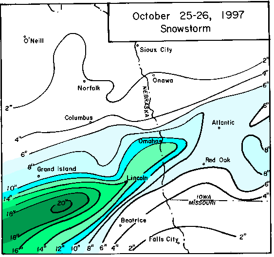
An early winter storm devastates the Lincoln and Omaha areas as 6 to 14 inches of snow fell over the metro areas!!! Downed power lines and extensive tree damage resulted from the combination of leaves still on the trees and the heavy wet snow. Of note was the change over from rain to snow over southeast Nebraska. While rain had changed over to snow during the late evening hours of the 25th in the Lincoln area, Falls City did not change over to snow until 11am on Sunday the 26th!!!
Snowfall Amounts
Clay Center   23 inches
Orleans       18 inches
Franklin      17 inches
Red Cloud     14 inches
Wilber        14 inches
Lincoln    13-14 inches
Gretna     13-14 inches
Papillion     12 inches
Utica         12 inches
Boystown    10.5 inches
Nehawka     8-10 inches
Valley       9.2 inches
Oakland IA     8 inches
 More Info and photos from the University of Nebraska High Plains Climate Center
Satellite and Radar Images
 Back to the Archive page
Warnings/Hazards
Forecast Discussion
Winter Weather
Severe Weather
Fire Weather
Drought
Storm Prediction Center
SubmitReport
Rivers And Lakes
River Forecasts
Missouri River Overview
Platte River Overview
Elkhorn River Overview
Ice Jam Risk
Local Information
Latest Briefing Packet
Weather Monitor
Winter Monitor
Preparedness
Storm Spotters
About Us
Other Useful Links
US Dept of Commerce
National Oceanic and Atmospheric Administration
National Weather Service
Omaha/Valley, NE
6707 North 288th Street
Valley, NE 68064-9443
402-359-5166
Comments? Questions? Please Contact Us.

