
Severe thunderstorms may produce damaging winds, large hail, and numerous instances of flash/urban flooding over parts of the central Plains and lower Missouri Valley. Hazardous heat will continue in the South, Desert Southwest and the California Central Valley this weekend. Isolated dry thunderstorms may increase the risk of fire starts and spread across the Four Corners region and vicinity. Read More >
Top 10 Weather Headlines of 2006
Severe thunderstorms and tornadoes dominated the 2006 weather headlines. A total of 761 severe weather events were logged by the Paducah NWS office in 2006, far exceeding the tallies of the past ten years. From 1996 to 2005, annual totals ranged from 241 to 407. Large hail was the main culprit for the increase in severe weather events in 2006. The tornado count of 34 was similar to that of 2002, 2004, and 2005. In 2003, there were 48 tornadoes, including the May 4-6 tornado outbreaks. From the mid 1990's until 2002, tornado activity was relatively low, averaging between 10 and 20 per year.
The following is a chronology of the ten most significant weather events in 2006. The events were chosen unscientifically. The primary rating factors are news media coverage, casualties, and the meteorological significance of the event.
|
1. Warmest January on Record - 2006 began with the warmest January since the 1930's at some locations. At Paducah, it was the warmest January on record. Daily average temperatures were above normal for 40 consecutive days.
|
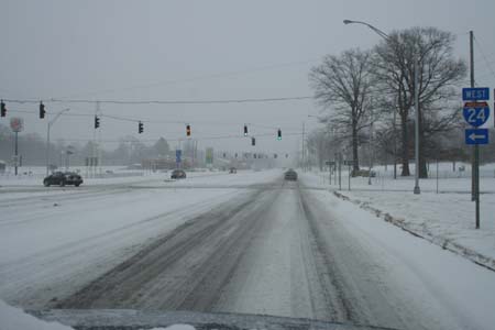 2. Feb. 17-19 Snow and Cold - The only real winter weather of the year featured back-to-back snowfalls and low temperatures in the single digits. Although neither snowfall was heavy, gusty winds piled up drifts. The winter weather followed on the heels of spring-like storms and even a small tornado. (Photo taken in Paducah by Beau Dodson). 2. Feb. 17-19 Snow and Cold - The only real winter weather of the year featured back-to-back snowfalls and low temperatures in the single digits. Although neither snowfall was heavy, gusty winds piled up drifts. The winter weather followed on the heels of spring-like storms and even a small tornado. (Photo taken in Paducah by Beau Dodson). |
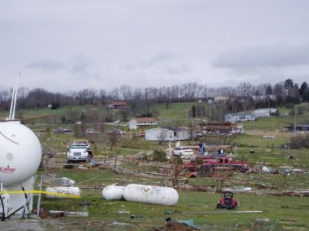 3. March 9-13 Severe Weather Outbreak and Flooding - 111 severe weather events occurred in this span of time, including widespread damaging winds. Waves of severe thunderstorms during this multi-day episode resulted in widespread flooding. Two persons were killed by an F-3 tornado that struck extreme northern Perry County, Missouri. Photo taken at site where car was hurled into propane tank along U.S. 61 in Perry Co., killing two persons. 3. March 9-13 Severe Weather Outbreak and Flooding - 111 severe weather events occurred in this span of time, including widespread damaging winds. Waves of severe thunderstorms during this multi-day episode resulted in widespread flooding. Two persons were killed by an F-3 tornado that struck extreme northern Perry County, Missouri. Photo taken at site where car was hurled into propane tank along U.S. 61 in Perry Co., killing two persons. |
 4. April 2 Severe Weather Outbreak - Tornadic supercells crossed western Kentucky and southeast Missouri, and a squall line caused widespread wind damage further north. An F-3 tornado passed near Hopkinsville, KY and destroyed or severely damaged over 200 homes. 28 persons were injured. Photo taken by webcam at Jennie Stuart Hospital in Hopkinsville. 4. April 2 Severe Weather Outbreak - Tornadic supercells crossed western Kentucky and southeast Missouri, and a squall line caused widespread wind damage further north. An F-3 tornado passed near Hopkinsville, KY and destroyed or severely damaged over 200 homes. 28 persons were injured. Photo taken by webcam at Jennie Stuart Hospital in Hopkinsville. |
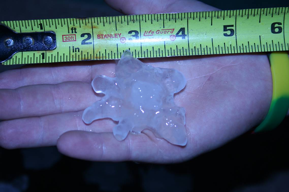
| 5. April 7 Hailstorms - Only five days after the major outbreak on April 2, numerous severe thunderstorms produced large hail during the afternoon and early evening. Tornadoes and wind damage narrowly missed our area, affecting western and middle Tennessee. The hail piled up into drifts and whitened the ground in some places. The largest hailstones were nearly the size of baseballs in Gibson County, Indiana. |
 6. April 30 Severe Weather Outbreak - Numerous reports of large hail, along with a few damaging wind gusts and a brief tornado, occurred in southern Illinois and southeast Missouri. Southern Bollinger County was struck with baseball-size hail. Photo taken by Sean Magee in Jackson, MO and forwarded courtesy of KFVS-12. 6. April 30 Severe Weather Outbreak - Numerous reports of large hail, along with a few damaging wind gusts and a brief tornado, occurred in southern Illinois and southeast Missouri. Southern Bollinger County was struck with baseball-size hail. Photo taken by Sean Magee in Jackson, MO and forwarded courtesy of KFVS-12. |
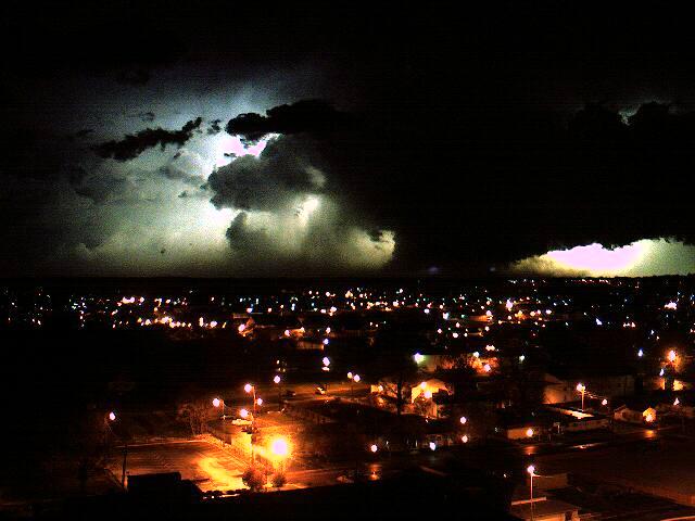
 7. May 25 Severe Weather Outbreak - Another widespread severe weather outbreak occurred during the late afternoon and evening hours. Many storms produced large hail, with some hailstones to the size of baseballs and tea cups. Damaging winds and a couple of tornadoes occurred. Photo at left of mammatus clouds over the Paducah National Weather Service office. Photo gallery here. 7. May 25 Severe Weather Outbreak - Another widespread severe weather outbreak occurred during the late afternoon and evening hours. Many storms produced large hail, with some hailstones to the size of baseballs and tea cups. Damaging winds and a couple of tornadoes occurred. Photo at left of mammatus clouds over the Paducah National Weather Service office. Photo gallery here. |
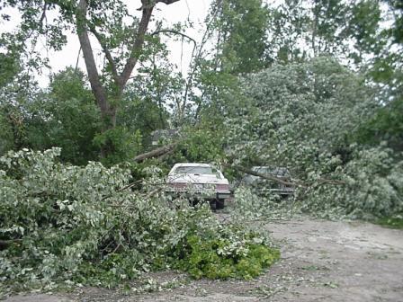 8. July 21 Extreme Wind Event - The Mt. Vernon area was struck hardest by a widespread, extremely damaging wind event that originated in the St. Louis area. Winds in excess of 90 MPH damaged or destroyed 14 percent of all homes (1,107 homes) in the city of Mt. Vernon, according to FEMA. Despite the intense destruction, only a handful of people were injured, and nobody was killed. Damage photo taken in Mt. Vernon. 8. July 21 Extreme Wind Event - The Mt. Vernon area was struck hardest by a widespread, extremely damaging wind event that originated in the St. Louis area. Winds in excess of 90 MPH damaged or destroyed 14 percent of all homes (1,107 homes) in the city of Mt. Vernon, according to FEMA. Despite the intense destruction, only a handful of people were injured, and nobody was killed. Damage photo taken in Mt. Vernon. |
 9. Sept. 12 Evansville Flash Flood - Major flash flooding occurred in a matter of minutes after torrential rain starting pounding the city of Evansville. A total of about 250 occupied structures sustained some degree of damage. Over 30 water rescues were conducted from cars stalled in floodwaters. (Photo of flooding in Evansville taken by Kris Conner). 9. Sept. 12 Evansville Flash Flood - Major flash flooding occurred in a matter of minutes after torrential rain starting pounding the city of Evansville. A total of about 250 occupied structures sustained some degree of damage. Over 30 water rescues were conducted from cars stalled in floodwaters. (Photo of flooding in Evansville taken by Kris Conner). |
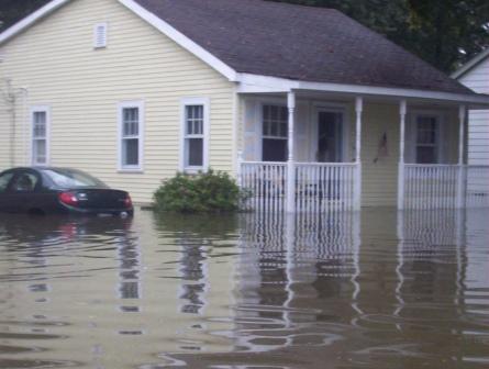
.JPG) 10. September 22 Severe Weather Outbreak and Major Flooding - The most intense tornado of the year occurred on the first day of fall. Several other tornadoes occurred during this outbreak, which was primarily during the late afternoon and early evening. The severe weather outbreak turned into a major flood event during the nighttime and early morning hours. Hundreds of residents were evacuated from their homes, crop damage was in the millions, and numerous roads were closed. The worst flash flooding was in counties bordering Tennessee and Arkansas. Photo taken in Crosstown, MO. 10. September 22 Severe Weather Outbreak and Major Flooding - The most intense tornado of the year occurred on the first day of fall. Several other tornadoes occurred during this outbreak, which was primarily during the late afternoon and early evening. The severe weather outbreak turned into a major flood event during the nighttime and early morning hours. Hundreds of residents were evacuated from their homes, crop damage was in the millions, and numerous roads were closed. The worst flash flooding was in counties bordering Tennessee and Arkansas. Photo taken in Crosstown, MO. |
|
Have a safe and happy 2007! |

