Top 10 Headlines of the Decade: 2000-09
The following weather events were ranked according to the responses of seventy participants of an informal, unscientific survey. The participants consisted mainly of meteorologists, emergency management officials, and trained spotters. The participants represented a broad geographical cross-section of the Paducah office's service area.
|
1. |
 2. Nov., 2005 Evansville Area Tornado - The deadliest tornado in Indiana since 1974 took the lives of two dozen persons in the middle of the night. About 200 others were injured. A mobile home park on the southern outskirts of Evansville suffered the vast majority of the fatalities and injuries. This F-3 tornado crossed the Ohio River three times during its 41-mile trek across three Ohio River counties of southwest Indiana as well as Henderson County, KY. Average score: 3.6. (Photo courtesy of Deaconess Women's Hospital in Evansville) 2. Nov., 2005 Evansville Area Tornado - The deadliest tornado in Indiana since 1974 took the lives of two dozen persons in the middle of the night. About 200 others were injured. A mobile home park on the southern outskirts of Evansville suffered the vast majority of the fatalities and injuries. This F-3 tornado crossed the Ohio River three times during its 41-mile trek across three Ohio River counties of southwest Indiana as well as Henderson County, KY. Average score: 3.6. (Photo courtesy of Deaconess Women's Hospital in Evansville) |

3. Sept. '08: Remnants of Ike - Wind gusts up to hurricane force over a period of several hours damaged hundreds of roofs and caused widespread power outages. The extensive tree damage caused by Ike would pale in comparison to the ice storm to follow in January of 2009. Ike set a new record for power outages for the state of Kentucky, only to be eclipsed by the ice storm several months later. About 50 people were injured, mostly by falling trees. Average score: 5.7. (Photo courtesy of Tony Crouch, Mayfield, KY). |
 4. April, 2002 Tornadoes - Three separate tornado outbreaks on the 21st, 24th, and 28th collectively killed three and injured over 100 people. The nation's first tornado fatality of 2002 occurred in Wayne County, IL on the 21st. On the 24th, a long-track tornado across Carter and Butler Counties in Missouri produced F-4 damage near Poplar Bluff. A tornado outbreak in the wee morning hours of April 28 was the result of a single supercell that tracked across Missouri, Illinois, and Kentucky. Average score: 5.8. (Aerial damage photo by NWS Paducah staff). 4. April, 2002 Tornadoes - Three separate tornado outbreaks on the 21st, 24th, and 28th collectively killed three and injured over 100 people. The nation's first tornado fatality of 2002 occurred in Wayne County, IL on the 21st. On the 24th, a long-track tornado across Carter and Butler Counties in Missouri produced F-4 damage near Poplar Bluff. A tornado outbreak in the wee morning hours of April 28 was the result of a single supercell that tracked across Missouri, Illinois, and Kentucky. Average score: 5.8. (Aerial damage photo by NWS Paducah staff). |
|
|
|
|
 7. May 6, 2003 Tornadoes - A total of 21 tornadoes occurred during the evening. Two persons were killed in an F-4 tornado that tracked 33 miles along the Ohio River Valley in extreme southern Illinois. Near Cape Girardeau, Missouri, the city of Jackson was struck directly by an F-3 tornado that caused well over 10 million dollars in damage. Average score: 6.1. (Aerial photo of demolished mobile homes in Massac County, IL by NWS staff). 7. May 6, 2003 Tornadoes - A total of 21 tornadoes occurred during the evening. Two persons were killed in an F-4 tornado that tracked 33 miles along the Ohio River Valley in extreme southern Illinois. Near Cape Girardeau, Missouri, the city of Jackson was struck directly by an F-3 tornado that caused well over 10 million dollars in damage. Average score: 6.1. (Aerial photo of demolished mobile homes in Massac County, IL by NWS staff). |

8. Dec. 22, '04 Snowstorm - Near-blizzard conditions and record 24-hour snowfall paralyzed travel just a few days before Christmas. Gusty winds piled one to two feet of snow into drifts up to five feet deep. Large sections of Interstate 24 in western Kentucky and Interstate 64 in southwest Indiana were closed or impassable for days. The National Guard was mobilized to rescue over 1,000 motorists stranded on the roads. Average score: 6.3. Photo of snow-clogged Indiana Route 168 near Fort Branch, IN (courtesy of Charlie Kiesel). |

9. May 8, '09 Southern IL/SE Missouri Windstorm - An extremely damaging, mesoscale wind event known as a derecho tore a path of destruction from Perry and northern Bollinger Counties of Missouri east across the Marion/Carbondale area to near Harrisburg, IL. Frequent, widespread gusts from 80 to 110 mph damaged over 10,000 homes in Williamson County alone. One fatality and numerous injuries were reported. The power outages and tree damage resulting from this storm were comparable to the January, 2009 ice storm in western KY. Average score: 6.6. Photo taken in Carrier Mills, IL by NWS Paducah staff. |
|
|
|
Have a safe and happy decade: 2010-2019! |


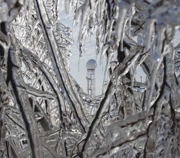
 5.
5.  6.
6.  10.
10.