
Scattered strong to severe thunderstorms may pose a risk for damaging wind gusts over the Carolinas, southeast Virginia, and the Tennessee Valley Sunday afternoon then the northern Plains from late afternoon into Sunday night. Monsoonal thunderstorms may cause locally considerable flash, urban, and small stream flooding in the Southwest U.S. the next few days. Read More >
Flash Flood east of Casper Monday Evening July 29, 2013
Strong thunderstorms rolled through Casper Monday evening, bringing gusty wind, hail, lots of rain, and a ton of lightning. Flash flooding was reported east of Casper on East Second Street between Wyoming Blvd. and Hat 6 Road as well as along the Clear Fork of Muddy Creek at the east end of Casper Mountain.
A Special Weather Statement was issued for the Casper area at 604pm highlighting the possibility of strong wind gusts, small hail, heavy rain, and frequent lightning. Another Special Weather Statement was issued at 732 pm when a strong thunderstorm was located about 12 miles southwest of Casper. A follow-up Special Weather Statement was issued at 803pm when the storm was over the east side of Casper.
A Flash Flooding warning was then issued by the NWS office in Riverton at 842pm for the east side of Casper through 1130pm. Flooding was being reported by the Natrona County Emergency Manager.

This next image is a gridded representation of cloud-to-ground lightning strikes over Natrona County from 600am July 29 through 6am July 30. The scale can bee seen across the top of the image. Red boxes indicate where 10 or more lightning strikes occurred in a 2.5km by 2.5km grid box.

Quite a bit of hail fell in the Kohl's parking lot as well. Click here to see the image.
The big story though was the short-duration rainfall. 24-hour amounts can be viewed by clicking here and opening a kmz file in Google Earth - then zoom in around Casper to see the values. It appears that Casper received rainfall from a quarter to nearly an inch in 24 hours from 6am Monday to 6am Tuesday. However, much of that fell in only 20 minutes or so Monday evening. The following image shows the 1 hour precipitation estimate from the Doppler Radar in Riverton ending at 823pm. The darker green-blue indicates 0.75 to 1.0 inches of precipitation in one hour. In addition, one half to three-quarters of an inch is estimated to have fallen in the eastern portions of the Sheep Herder Hill fire area.

There have been reports of some damage from the flooding from around East Second Street and Hat 6 Road to the NE side of Casper mountain. Specifically, several homes along the Clear Fork of Muddy Creek sustained damage. In addition, a couple of vehicles were washed downstream as well as a couple of ATVs. The main damage appears to be to areas downstream of the recent burn scar on Casper Mountain.
Here's a shot of some damage to a vehicle -

And to the stream bed from the debris -
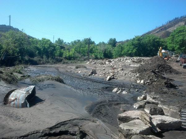
Thanks to Stew Anderson and Teresa Simpson of the Natrona County Emergency Management for the damage images.

