National Weather Service United States Department of Commerce

Marine and Coastal Impacts from Imelda; Unsettled Weather in the West

Swells and high surf from both Imelda and Humberto are expected to bring dangerous marine conditions and rip currents to much of the East Coast over the next several days. A series of Pacific frontal systems will bring waves of showers and thunderstorms to portions of northern California and the Pacific Northwest through midweek. Read More >

The National Weather Service
Building a Weather-Ready Nation

Forecast | Monitoring & Reporting | Safety


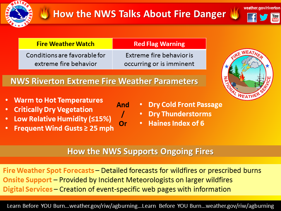
Elevated to extreme fire weather conditions will be common Sunday especially east of the Divide, and Sweetwater County. A weather system and strong cold front will be approaching Western WY Sunday afternoon. The wind will increase ahead of this front along with very dry relative humidity.  A Red Flag Warning for Extreme Fire Spread Danger has been issued for Natrona and Johnson Counties from noon until 8 PM Sunday.  Please note: Red Flag Warnings will not be issued for areas west of Johnson and Natrona Counties even if weather parameters meet criteria since fuels are not considered critical as of 7/8.


Click to enlarge Click to enlarge                                      
 Click to Enlarge


Red Flag Warnings

(Graphic created at 3:19 AM Sunday)

Click to Enlarge.


Graphics for Day 1 (Sunday) - Please Note: These Graphics below will automatically update periodically through the day, and will change days of the week towards late afternoon.

Click to enlarge Click to enlarge

Click Image To Enlarge

This image shows the expected high temperature (please see header for day).

Click Image To Enlarge

This image shows the expected minimum relative humidity. 
Click to enlarge Click Image To Enlarge

Click Image To Enlarge

This image shows the expected peak wind gusts over the 12 hour period ending at the time stated in the header. Do not burn if wind gusts are expected to be 20mph or more (blue, yellow, or red shades = no burning)

Click Image To Enlarge

This image shows the expected peak wind gusts over the 12 hour period ending at the time stated in the header. Do not burn if wind gusts are expected to be 20mph or more (blue, yellow, or red shades = no burning)


Graphics for Day 2 (Monday) - Please Note: These Graphics below will automatically update periodically through the day, and will change days of the week towards late afternoon. 

Click to enlarge Click to enlarge

Click Image To Enlarge

This image shows the expected high temperature (please see header for day).

Click Image To Enlarge

This image shows the expected minimum relative humidity. 
Click to enlarge Click Image To Enlarge

Click Image To Enlarge

This image shows the expected peak wind gusts over the 12 hour period ending at the time stated in the header. Do not burn if wind gusts are expected to be 20mph or more (blue, yellow, or red shades = no burning)

Click Image To Enlarge

This image shows the expected peak wind gusts over the 12 hour period ending at the time stated in the header. Do not burn if wind gusts are expected to be 20mph or more (blue, yellow, or red shades = no burning)


Monitor our Severe Weather Summary Page for current Warnings, Watches, and Advisories. What's the difference?
Current Weather Story Check the latest Weather Story graphic for an overview of the area forecast.
NWS Riverton Radar Check out what's on the radar.
Riverton | Pocatello | Cheyenne | Billings | Salt Lake City | Rapid City | Mosaic
Submit storm reports/images and keep up to date with us on Facebook!
Other reporting methods include eSpotter, email (cr.wxriw@noaa.gov), or by phone at 1-800-211-1448.
Check the latest Public Information Statement for the latest storm reports.
WyDoT's Webpage Monitor current road conditions by visiting the Wyoming Dept. of Transportation (WYDOT) or by calling 5-1-1.


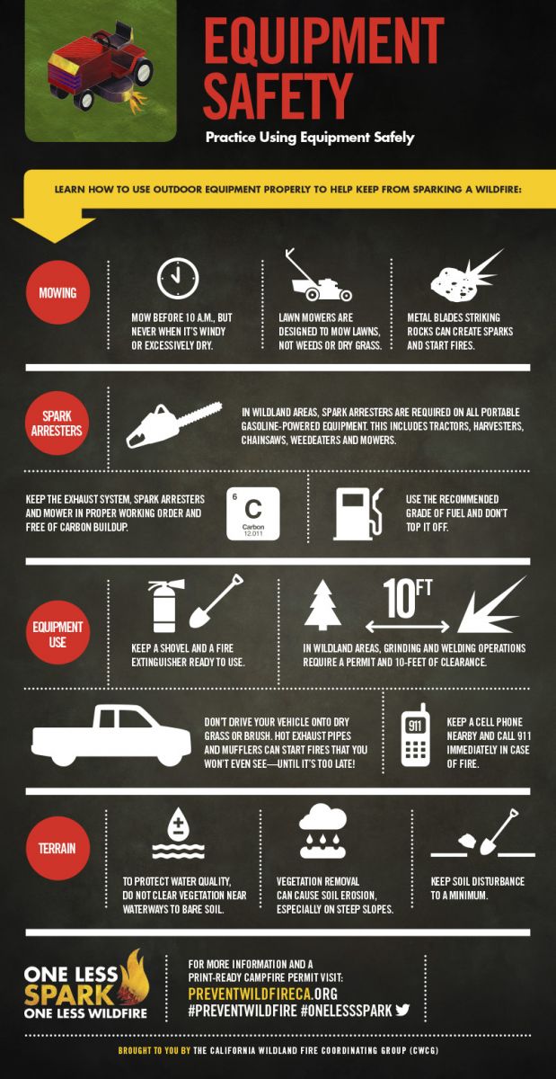
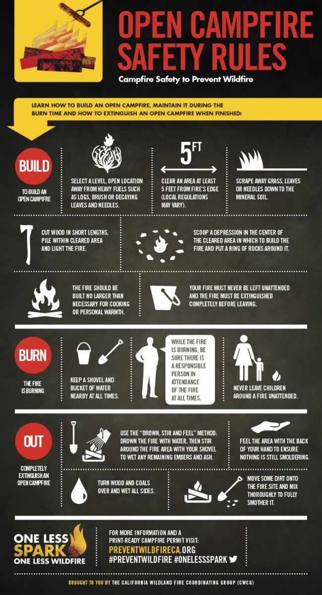
One Less Spark Infographics - Click To Enlarge
Click to enlarge Click to enlarge
Click to enlarge

Click to enlarge


Emergency Kit      |      Firewise


Learn more about the National Weather Service's efforts to build a Weather-Ready Nation!