
A dangerous, record heat wave continues across portions of the West through Tuesday. High rip current risk and dangerous surf continue through the weekend. There are flash flooding concerns through the weekend for portions of the Southeast and Southwest. Read More >

*** Little Wind River near Riverton Crested at 10.19 feet early Sunday Evening ***
It is still recommended that people stay away from flooded areas near the Little Wind River, and any other water bodies that have risen over the last few days.
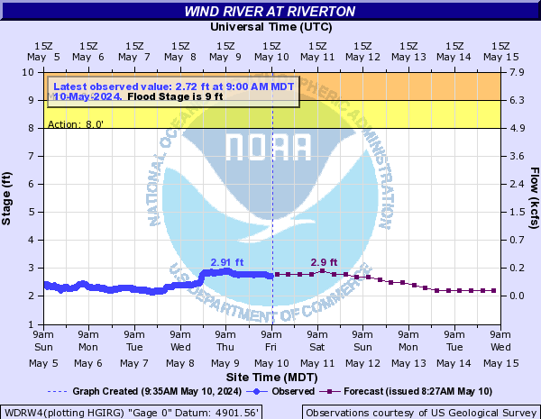
Flooding of the Little Wind River near Riverton: Excessive ruoff due to record rainfall in the southern Wind River Basin resulted in flooding on the Little Wind River near Riverton over the weekend. The river crested Sunday evening around 10.2 feet and is the 3rd highest crest of all-time trailing only the 2010 and 1963 floods.
Do not drive through flooded areas. The roadway may have been washed out or the road surface unstable. Please stay away from emergency personnel conducting operations along and near the river.
 |
 |
|
for Wind River at Riverton |
for Little Wind River near Riverton |
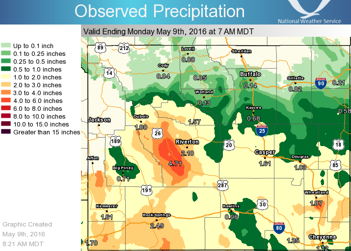
Heavy Rain / Potential Flooding: Here is a comprehensive list of 3-day rain totals through Monday morning. Travelers can keep up-to-date with current road conditions by visiting wyoroad.info.
General Impacts
 |
Water covered roadways may still be present, causing travel difficulties. Travelers are encouraged to remember to "Turn Around Don't Drown!" Roadways across western Wyoming may also become slick due to accumulating hail. |
 |
The impacts from flooding will remain a concern for at least the next couple days. Please be sure to stay away from flooded areas and allow emergency personnel plenty of room to conduct their operations. |
 |
Most cases of hypothermia occur in the warm season when people are outdoors and exposed to wet and cold conditions. If you are invovled in flood relief efforts, be sure to move inside and warm your body, drink plenty of fluids, and eat nutritious meals. |

Here are the latest graphics dealing with rain and snow through Sunday. (click for a larger view):
 |
 |
|
|
thru Monday morning |

Want to track the storm? Here are the local and regional radar loops:
 |
  |

Latest WYDOT Road Information Map
| Social Media:Tweets by @NWSRiverton | |
|
Twitter: www.twitter.com/NWSRiverton Facebook: www.facebook.com/NWSRiverton |
Here are some additional links to help monitor the weather situation:

