
Severe thunderstorms will continue to be possible over parts of the northern Plains and upper Midwest through Saturday which could bring large hail, damaging winds, and possible tornadoes. Heavy to excessive rainfall may produce flooding over a part of the Midwest today. Elevated to critical fire weather are expected today into this weekend over parts of the central Rockies and Great Basin. Read More >

Rivers and creeks will continue to run near bankfull across central Fremont County through Sunday morning with some minor flooding possible. Most rivers and creeks either had crested or were cresting across central Fremont County on Saturday. Snowpack below the 10,000 foot level had mostly melted off and cooler temperatures are expected on Sunday, which will also reduce the rate of snowmelt runoff.
 |
|
|
Click on Image to Enlarge. |
|
 |
|
|
(Click to Enlarge) |
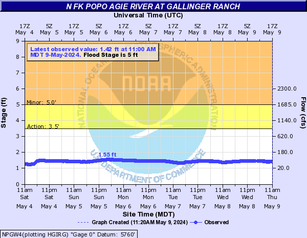
Hydrograph of the North Fork of the Popo Agie River northwest of Lander. The river should continue to recede over the next few days as snowmelt runoff rates decrease. (Click to Enlarge) |
 |
 |
|
(Click to Enlarge) |
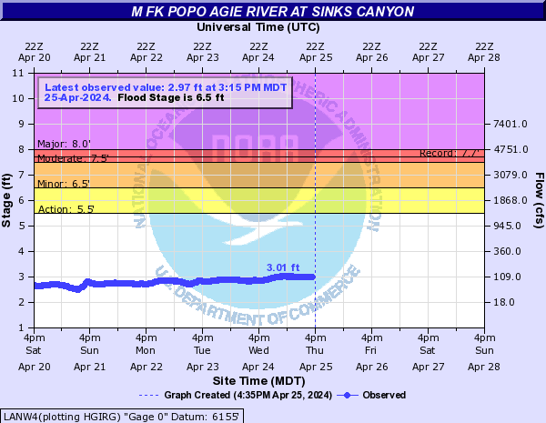
Hydrograph of the Middle Fork of North Fork of the Popo Agie River in Sinks Canyon. (Click to Enlarge) |

River Gauge Stages and Forecasts (AHPS)
|
|
||||
|
above Hudson near Lander |
near Mortimore Lane Bridge - Lander |
at Fort Washakie |
||
 |
 |
 |
||
|
near Riverton |
at Riverton |
near Dubois |
||
 |
 |
 |
||
|
|
||||
|
at Casper |
|
near La Barge |
||
 |
 |
 |
||
| Social Media:Tweets by @NWSRiverton |
Here are some additional links to help monitor the weather situation:

