Snow/Rain Totals| Reporting | Safety
A large storm system moved through the region this weekend, depositing over 20 inches of snow on Casper Mountain, with 5 to 10 inches of snow around Casper. Some of the higher valley locations recorded 2 to 3 inches of very wet snow, however most areas below about 6500ft did not change over from rain, or only did so very briefly.
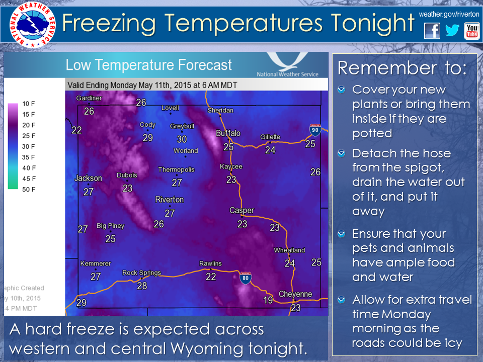
Cold air remained behind for Sunday night and Monday morning as a hard freeze hit much of western and central Wyoming.
 |
|
Click to Enlarge |
| County | Station Name | Snowfall |
|---|---|---|
| Fremont | Townsend Creek Snotel | 12 |
| Sinks Canyon - MU Camp | 10 | |
| 9.5 SW Lander | 9 | |
| Hobbs Park Snotel | 9 | |
| South Pass Snotel | 8 | |
| South Pass | 8 | |
| Jeffrey City | 6 | |
| 7 SW Lander | 5 | |
| 6 SW Lander | 4.6 | |
| Red Canyon | 4 | |
| Deer Park Snotel | 4 | |
| 15 W Jeffrey City | 3 | |
| Atlantic City | 2.5 | |
| 3 SSE Lander | 2 | |
| St. Lawrence Alt Snotel | 2 | |
| 7 WNW Lander | 2 | |
| Cold Springs Snotel | 2 | |
| 9 SSE Lander | 1.8 | |
| Lander | 0.5-1.5 | |
| 1 SW Lander | 1 | |
| 6 SE Lander | 1 | |
| Lander Airport | 0.7 | |
| Hot Springs | Owl Creek Snotel | 1 |
| Johnson | Little Goose Snotel | 9 |
| Cloud Peak Reservoir Snotel | 7 | |
| Soldier Park Snotel | 7 | |
| Hansen Sawmill Snotel | 2 | |
| Bear Trap Meadow Snotel | 1 | |
| 17 NNW Kaycee | 0.3 | |
| Spring Creek Divide Snotel | 4 | |
| Indian Creek Snotel | 3 | |
| Kemmerer/Diamondville |
3 |
|
| Kelley Ranger Station Snotel | 3 | |
| Blind Bull Summit Snotel | 2 | |
| Cottonwood Creek Snotel | 2 | |
| Fossil Butte | 2 | |
| Salt River Summit Snotel | 1 | |
| Natrona | Casper Mountain | 16-22.5 |
| Casper Mountain Snotel | 19 | |
| Reno Hill Snotel | 17 | |
| 5 SW Casper | 12 | |
| 2 S Casper | 10.5 | |
| 10 WSW Casper | 9.1 | |
| 11 ESE Casper | 8.8 | |
| 4 WSW Casper | 6.1 | |
| Grave Spring Snotel | 6 | |
| 11 WSW Casper | 6 | |
| 4 WSW Casper | 5.7 | |
| Midwest | 5.5 | |
| 2 E Evansville | 5 | |
| Casper | 2-4.2 | |
| Powder River | 4 | |
| Park | 3 NE Sunshine | 0.5 |
| Sublette | Triple Peak Snotel | 2 |
| Snider Basin Snotel | 1 | |
| Pinedale | 0.6 | |
| 14 NW Pinedale | 0.3 | |
| Sweetwater | 7 SE Rock Springs | 0.7 |
| 5 N Farson | 0.3 | |
| Rock Springs | 0.3 | |
| Teton | Darwin Ranch | 4 |
| Washakie | Middle Powder Snotel | 3 |
 |
Monitor our Severe Weather Summary Page for current Warnings, Watches, and Advisories. What's the difference? |
 |
Check the latest Weather Story graphic for an overview of the area forecast. |
 |
Check out what's on the radar. Riverton | Pocatello | Cheyenne | Billings | Salt Lake City | Rapid City | Mosaic |
 |
Submit storm reports/images and keep up to date with us on Facebook!a |
 |
Follow us on Twitter for additional information. The hashtags #wywx, #Wyoming, and #wxreport can be used for reporting current weather conditions, including snowfall. |
 |
Other reporting methods include eSpotter, email (cr.wxriw@noaa.gov), or by phone at 1-800-211-1448. |
 |
Check the latest Public Information Statement for the latest storm reports. |
 |
Monitor current road conditions by visiting the Wyoming Dept. of Transportation (WYDOT) or by calling 5-1-1. |
Winter Safety Kit | Vehicle Safety Kit
 |
Learn more about the National Weather Service's efforts to build a Weather-Ready Nation! |