
Heavy thunderstorms will continue areas of excessive rainfall and locally considerable flooding over parts of the southern Plains into the mid-Mississippi River Valley through Friday. Heavy to excessive rainfall may bring flash and urban flooding, along with isolated riverine flooding to a part of the Upper Midwest Thursday. Read More >
Summary | Forecasts | Snow and Wind Reports | Travel Center | Monitoring & Reporting | Safety
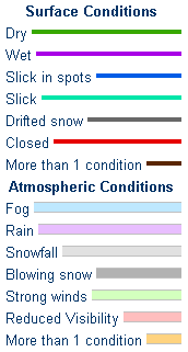
SYNOPSIS:
December 4, 2017 - The winter storm has exited the region, and snow has ended. Partly cloudy skies will prevail, along with much colder temperatures today, some 15 to 30 degrees colder than Sunday. Add the wind, and it will feel even colder than that to exposed skin. People should be prepared for the cold and for hazardous driving conditions left behind by the storm.
|
|
|
|
|
|
|
|
|
Multimedia Briefing |
 |
 |
|
Click Image To Enlarge |
Click Image To Enlarge |
 |
 |
|
Click Image To Enlarge |
Click Image To Enlarge |
|
Snow Totals and Wind Reports will be posted and updated here once the storm occurs |
|
|
Summary | Forecast | Travel Center | Monitoring & Reporting | Safety
|
|
|
| Road Conditions and Web Cameras | |||
 |
|||
|
|
|
|
|
 |
 |
 |
 |
|
|
|
|
|
 |
|
 |
 |
|
|
|
|
|
 |
 |
 |
 |
|
|
|
|
|
 |
 |
 |
 |
If you plan to travel, we recommend checking road conditions along your route and staying on top of road closures here. If you are on Twitter, follow the hashtag: #WyoRoad (or look below) for the latest weather affecting roads and road conditions in and around Wyoming.
| Tweets by @NWSRiverton | #WyoRoad Tweets |
|
Get the play-by-play on this storm and contribute your own snow reports to #wywx |
On the road? Tweet road conditions to #WyoRoad!
|

Summary | Forecast | Travel Center | Monitoring & Reporting | Safety
PLEASE SEND US YOUR SNOW REPORTS (CLICK HERE)
 |
Monitor our Severe Weather Summary Page for current Warnings, Watches, and Advisories. What's the difference? |
 |
Check the latest Weather Story graphic for an overview of the area forecast. |
 |
Check out what's on the radar. Riverton | Pocatello | Cheyenne | Billings | Salt Lake City | Rapid City | Mosaic |
| Submit storm reports/images and keep up to date with us on Facebook! | |
 |
Submit storm reports/images and keep up to date with us on Twitter! |
 |
Other reporting methods include submitting an online report, email (cr.wxriw@noaa.gov), or by phone at 1-800-211-1448. |
 |
Check the latest Public Information Statement for the latest storm reports. |
| Monitor current road conditions by visiting the Wyoming Dept. of Transportation (WYDOT) or by calling 5-1-1. |
Summary | Forecast | Travel Center | Monitoring & Reporting | Safety

Winter Safety Kit | Winter Weather Safety
 |
Learn more about the National Weather Service's efforts to build a Weather-Ready Nation! |


