
Hurricane Erin may bring isolated flash and urban flooding, landslides or mudslides, and possible tropical storm conditions to Puerto Rico and the U.S. Virgin Islands this weekend. Scattered thunderstorms and heavy rainfall may bring areas of flooding this weekend over the Upper Midwest. A tropical disturbance will bring locally heavy rain and mainly urban flash flooding to far southern Texas. Read More >
Links | Warnings and Radar| Lightning Forecasts
Weather Outlooks| Fuels and Fire Danger Maps
 |
|||||||||||||||||||||||
|
|||||||||||||||||||||||
| WFO Riverton Fire Weather Page | |||||||||||||||||||||||
| Fire Weather Planning Forecast For Zone 282 | |||||||||||||||||||||||
| Latest Road Information/Closures (As of 8 PM 7/10 - Wyoming Highway 31 is open!) | |||||||||||||||||||||||
| Click Boxes to Expand Product on Page | |||||||||||||||||||||||
|
|||||||||||||||||||||||
Current Watch/Warning/Advisory Map and Radars
(Click thumbnails to expand Images)
| Watch/Warnings/Advisories | Riverton Radar Loop | Billings, MT Radar Loop |
 |
 |
 |
| Severe Weather Outlook | Weather Story | Northern Rockies Radar |
 |
 |
Thunderstorm Potential Forecasts (updated hourly)
(Click thumbnails to expand Images)
|
|
|
|
|
|
 |

|
 |
 |
 |
|
|
|
|
|
|
 |

|
 |
 |
 |
Fire Weather Outlook and Forecasts (Temperature, Wind and RH)
(Click thumbnails to expand Images)
| Day 1 Fire Weather Outlook | Day 2 Fire Weather Outlook | Day 3 Fire Weather Outlook |
 |
 |
 |
| Day 1 Highs | Day 2 Highs | Day 3 Highs |
 |
 |
 |
| Day 1 MIN RH | Day 2 MIN RH | Day 3 MIN RH |
 |
 |
 |
| Peak Wind over the next 3 hours | Peak Wind over the next 12 hours | Peak Wind between 12 to 24 hours |
 |
 |
 |
| Today's Forecast Rain Amounts | Tomorrow's Forecast Rain Amounts | Day 3 Forecast Rain Amounts |
 |
 |
 |
USFS Fire Danger Graphics and Fuels
(Click thumbnails to expand Images)
|
|
|
|
 |
 |
 |
|
|
|
|
|
 |
 |
 |
 |
|
|
|
|
|
 |
 |
 |
 |
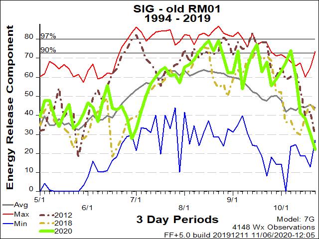
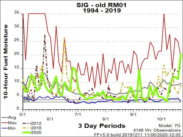
| RM01 ERC Fuels Graph |
|
|
 |
 |
 |
Return to NWS Riverton Homepage
 |
Building a Weather-Ready Nation |


