
A couple of frontal boundaries will move east and south from the Plains to the Gulf and Atlantic coastlines. These boundaries will focus showers and thunderstorms through the weekend, with scattered severe thunderstorms from the Southern Plains and across the Gulf Coast states. Locally heavy rainfall may also occur, which may be welcome news across drought areas. Meanwhile, heat spreads westward. Read More >
Links | Map | Warnings, Radar, & Satellite | Fire & Thunder Forecasts
Outlooks and Climate| Fuels and Fire Danger Maps
 |
||||||||||||||||||||||||||||||||
|
||||||||||||||||||||||||||||||||
| Twin Lakes Wildfire Inciweb Page | ||||||||||||||||||||||||||||||||
| WFO Riverton Fire Weather Page | ||||||||||||||||||||||||||||||||
| Fire Weather Planning Forecast For Zone 286 - Absaroka Mountains/Northern Shoshone National Forest | ||||||||||||||||||||||||||||||||
| Click Boxes to Expand Product on Page | ||||||||||||||||||||||||||||||||
|
||||||||||||||||||||||||||||||||
Current Warnings, Radar, and Satellite
(Click thumbnails to expand Images)
 |
 |
|
|
Click Image to Enlarge |
|
|
|
|
 |
 |
 |
|
|
|
|
|
|
Storm Prediction Center Critical Fire Areas and Thunderstorm Forecasts
(Click thumbnails to expand Images)
|
|
|
|
 |
 |
 |
|
|
|
|
 |
 |
 |
|
|
|
|
 |
 |
 |
|
|
|
|
|
|
 |
 |
 |
 |
 |
|
|
|
|
|
|
 |

|
 |
 |
 |
|
|
|
|
|
|
 |

|
 |
 |
 |
Weather Outlook and Climate Information
(Click thumbnails to expand Images)
| Local Precipitation, Wind, and Humidity Information (NWS) |
|
|
|
|
|
 |
 |
 |
 |
|
|
|
|
|
 |
 |
 |
 |
|
|
|
|
|
|
|
 |
 |
 |
 |
|
|
|
|
|
 |
 |
 |
 |
USFS Fire Danger Graphics and Fuels
(Click thumbnails to expand Images)
|
|
|
|
 |
 |
 |
|
|
|
|
|
 |
 |
 |
 |
|
|
|
|
|
 |
 |
 |
 |
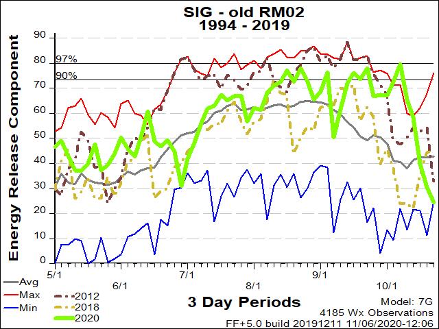
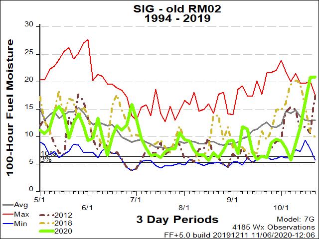
| RM02 ERC Fuels Graph |
|
|
 |
 |
 |
Return to NWS Riverton Homepage
 |
Building a Weather-Ready Nation |


