A significant heat wave continues for the Rockies, Northern Plains, and Great Lakes into the Mid-Atlantic, peaking in intensity through midweek and lingering across parts of the Northern Plains and Midwest until this weekend. Excessive rainfall my bring life-threatening and locally catastrophic flash and urban flooding across portions of southwestern Texas through early Friday. Read More >
|
Wyoming Flood Awareness - Flash Flooding
Floods are one of the most common hazards in Wyoming. Flood effects can be local, impacting a neighborhood or community, or very large, affecting entire river basins and multiple communities. The steep and varied terrain of Wyoming coupled with diverse soil conditions contribute to flash floods and their intensity.
All floods are not alike. Some floods develop slowly, sometimes over a period of days. However, flash floods can develop quickly, sometimes in just a few minutes. Some flash floods occur well downstream from where the rain fell, and take a considerable amount of time (1-3 hours) to reach a location. Therefore, even if the weather is dry at your location, you could still be susceptible to a flash flood. This is especially true if you are located near steep terrain, narrow canyons, or similar locations. Flash floods can be accompanied by a dangerous wall of water that carries rocks, mud, and other debris, sweeping away most things in its path. Flash floods in Wyoming typically occur from May through September with a peak in late July and early August. The peak in flash floods in July and August is partially attributed to monsoon moisture surging northward out of the Desert Southwest and Mexico. In fact, two Colorado researchers found the probability of recurrence of severe weather events were likely tied to this monsoon surge. Flash Floods usually occur from mid-afternoon through late evening, but may occur at any time of day.
Rainfall rate refers to the intensity of the rain per unit time. It is usually expressed in inches per hour. Two inches of rain that falls in 30 minutes (average rainfall rate = 4 in/hr) will have a much larger impact than 2 inches of rain that falls over a 4-hour period (average rainfall rate = 0.5 in/hr).
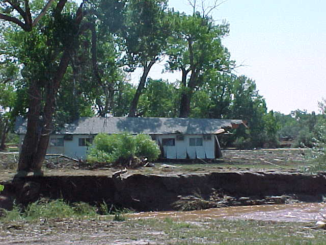
Wyoming Flash Flood History: One of the worst flash floods in Wyoming history occurred on August 1, 1985, in Cheyenne. By late afternoon, thunderstorms began to affect Cheyenne producing record amounts of rainfall. In approximately a 3-hour time span, six-plus inches of rain fell across the city. The severe flooding resulted in 12 deaths, 70 people injured, and total damages exceeded $61 million. Most of the deaths occurred along Dry Creek when people were swept away in their cars as they tried to cross flooded streets.
In 2011, flash flooding along Highway 130 near Saratoga claimed the lives of 4 people. They were travelling along the highway at night after evacuating a nearby campground. Their van then came upon a section of road that had been washed away by the swollen Brush Creek, plummeting 9 feet into the raging waters. A vehicle driven by an emergency manager also fell into the creek; the road washout was hidden by the cover of night, which sadly illustrates the increased danger posed by night time flooding. Van in Brush Creek near Saratoga Very heavy rainfall from an intense thunderstorm resulted in significant flooding in southern sections of Green River on August 17, 2007. Within 25 minutes, between 1.25 inches and 1.75 inches of rain was measured. The hardest hit area was the southern section of Green River which is next to a steep hill that rises about 500 feet above the surrounding terrain. This rain by itself would have done some flooding, but the steep terrain in very close proximity greatly enhanced the magnitude of the flooding. A fence at the landfill was washed out by a wall of water six feet high. Many yards and streets on the south side of Green River were covered with six to eight inches of mud. Torrential rainfall in canyons or on mountain passes can cause mudslides and falling rock. Heavy rain between 1.5 and 2 inches in about an hour caused a mudslide across the East Entrance Road near Sylvan Pass in Yellowstone National Park on July 18, 2004. Four vehicles and 16 people were trapped for 3 hours. 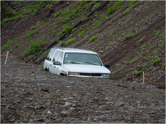 A mudslide traps a vehicle near Sylvan Pass in Yellowstone National Park
|
| Cheyenne, WY | Riverton, WY | Billings, MT | Rapid City, SD | Salt Lake City, UT |
| 800-269-6220 | 800-211-1448 | 406-652-0851 | 605-341-7531 | 801-524-5133 |