
Extreme heat continues today from the central Plains to the lower Mississippi River Valley, over southeast Montana, and from southern California into the Southwest Deserts. Extreme Heat Warnings remain in effect. Severe thunderstorms capable of strong to severe wind gusts and large hail are possible across the Great Lakes into the Ohio Valley today into tonight. Read More >
Links | Map | Warnings, Radar, & Satellite | Fire & Thunder Forecasts
| Fuels and Fire Danger Maps
 |
 |
 |
|
Click Image To Enlarge This image shows the expected peak wind gusts over the next 12 hours. |
Click Image To Enlarge This image shows the expected peak wind gusts over the 12 hour period ending at the time stated in the header.
|
 |
 |
|
Click Image To Enlarge This image shows the expected peak wind gusts over the 12 hour period ending at the time stated in the header.
|
Click Image To Enlarge This image shows the expected peak wind gusts over the 12 hour period ending at the time stated in the header.
|
 |
 |
|
Click Image To Enlarge This image shows the expected minimum relative humidity today.
|
Click Image To Enlarge This image shows the expected minimum relative humidity tomorrow. |
Current Warnings, Radar, and Satellite- Click to Enlarge
 |
 |
|
|
Click Image to Enlarge Teton Pass, looking East |
|
|
|
|
|
 |
 |
 |
|
|
|
Storm Prediction Center Critical Fire Areas and Thunderstorm Forecasts - Click to Enlarge
|
|
|
|
 |
 |
 |
|
|
|
|
 |
 |
 |
|
|
|
|
 |
 |
 |
|
|
|
|
|
|

|

|

|

|

|
|
|
|
|
|
|
 |

|
 |
 |
 |
|
|
|
|
|
|
 |

|
 |
 |
 |
USFS Fire Danger Graphics and Fuels - Click to Enlarge
|
|
|
|
 |
 |
 |
|
|
|
|
|
 |
 |
 |
 |
|
|
|
|
|
 |
 |
 |
 |
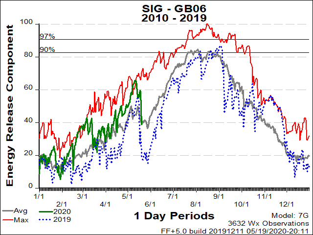
| BT National Forest ERC Fuels Graph |
|
|
 |
 |
 |
Return to NWS Riverton Homepage
 |
Building a Weather-Ready Nation |


.png)


