
Dangerous, record-breaking heat will intensify across most of the central and eastern U.S this week. Heat indices will likely exceed 100 degrees. Heat is likely to continue across the eastern U.S. through the Independence Day holiday weekend. Critical fire weather conditions will continue today and likely Tuesday across portions of the Four Corners and northern High Plains. Read More >
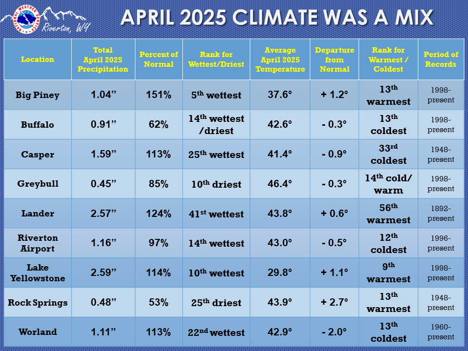
| The April 2025 climate summaries for Big Piney, Buffalo, Casper, Greybull, Lake Yellowstone, Lander, Riverton, Rock Springs, and Worland are now available online. |
 |
|
The month of April had a mix of cooler and warmer temperatures, along with a mix of wetter and drier than normal precipitation. It started with a cold front moving through the area and dropping snow and grauple. The 1st snow was pretty much everywhere, with winter weather advisories for the mountains. A front on the 4th saw snow mainly east of the Divide. Temperatures started off fairly close to normal in April, although the 5th had a couple of record breaking lows (Greybull and Worland). It became much warmer, windy, and drier the second week except for a storm bringing mountain snow and valley rain to the west and northwest on the 9th. Ridging brought much warmer temperatures the 11th-13th. The hottest day of the month was the 11th. Casper and Lander both broke daily records that day, and had their earliest 80-degree day of the year on record. Several other sites broke daily high records on those days. It stayed nice and warm, even above normal (10 - 20 degrees on the 15th). Then, on the 16th, an abrupt Springtime change to the weather arrived as a strong cold front pushed south and brought snow to even the lower elevations of the Cowboy State. There were Winter Storm Warnings and Advisories across much of the state. Snowfall on the 17th-18th ranged from 1 inch to 14 inch in Fremont County low areas, and 18 to 26 inches at higher elevations. Elsewhere snow ranged from 2 to 8 inches, with 10 to 13 at higher elevations. Easter weekend was fairly quiet with a few isolated showers and lower temperatures. Those rose to more seasonable values after the weekend. The next week had gusty winds, and isolated showers and thunderstorms. The 24th saw another front push through the area, with rain being the main attraction. Temperatures dipped that day, but quickly recovered. A cold front on the 28th brought more rain and high elevation snow, and temperatures dropped again. The 29th was sunny, but another front came through on the last day of the month with more cold temperatures and rain across the area. Check the CLMs for more specifics on daily records set at the various locations. See the links above for details for individual sites or click here for Water Year Precipitation summaries for more locations. If you would like additional, or more in-depth climate information, please refer to our Climate Page. From the Riverton Home Page, hover over the "Climate and Past Weather" tab, and select the "Local" option. Under the "Observed Weather" tab you can then find the Daily Climate Report (CLI), the Preliminary Monthly Climate Data (CF6), and the Monthly Weather Summary (CLM). The Daily Climate Report will have the weather data for the day (from midnight to 1159 pm). The Monthly Climate Data (CF6) will have this data for each day of the month, compiling all the daily data into one form. There is also a link to the Record Event Reports (RER) and the Annual Climate Report (CLA). |
|

