
A heat wave over the Southwest will intensify this week, peaking and expanding into the Intermountain West and northern High Plains this weekend. Critical to extremely critical fire weather conditions are forecast from the Northwest and the northern Great Basin this weekend. Particularly Dangerous Situation Red Flag Warnings have been issued. Read More >
Western and Central Wyoming
Weather Forecast Office
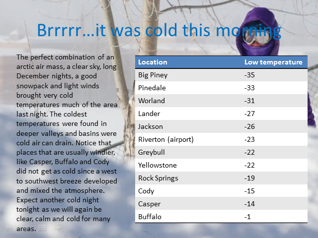
It was a chilly Tuesday night (Dec 30 - Dec 31) with extreme cold temperatures felt across western & central Wyoming. The cooperative site at Daniel in the Upper Green River Basin bottomed out at 48 below zero. Below is a quick summary of the lows that occurred Tuesday night.
 |
 |
| A complete listing of lows for December 31st. |
Forecasts
Severe Weather
Forecast Discussion
User Defined Forecast
Fire Weather
Activity Planner
Hourly Forecasts
Snow and Avalanche
Aviation Weather Decision Support
Hydrology
SnoTel Page
Rivers and Lakes
Weather Safety
Preparedness
SkyWarn
StormReady
NOAA Weather Radio
US Dept of Commerce
National Oceanic and Atmospheric Administration
National Weather Service
Western and Central Wyoming
12744 West U.S. Hwy 26
Riverton, WY 82501
307-857-3898
Comments? Questions? Please Contact Us.

