
Well above normal temperatures are forecast to shift from the northern Plains through the Northeast U.S. over the long holiday weekend. A few strong to severe thunderstorm will be possible as well along with a potential for excessive rainfall. A tropical or subtropical depression could form off the Southeast U.S. coast over the weekend while drifting northward to northeastward. Read More >
 |
Building a Weather-Ready Nation |
Summary | Forecast | Current Conditions | Safety
An active fall and winter storm season brought an abundance of snow to the mountains this water year, bringing back a lot of memories of the 2011 Snow Year, a year that brought significant flooding to parts of central Wyoming. The transition to warmer temperatures in May often signals the majority of mountain snowmelt. Even during years of average or below normal snowpack, a quick warm-up can rapidly melt snow and lead to flooding of mountain streams and tributaries. Conversely, a record snow pack could potentially cause no flooding if the snow is melted off slowly.
|
So what do we look for when trying to forecast a snowmelt flood event?
1. A significant high elevation rain event
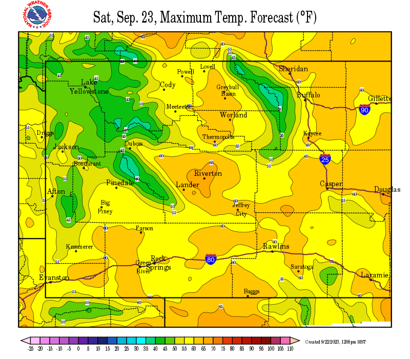
2. A significant warm up (over 70 degrees in the low elevations for 3 or more days) with temperatures remaining above 40 degrees in the mountains at night
3. A cold spring that holds onto the snow pack well into late May or early June (this is what happened in 2011) |
Otherwise, we need to hope for a nice, mild warm period with freezing temperatures at night to help the water come down at a pace that can be handled by the rivers. The snow pack is very healthy this year and we haven't even had our big spring snow season yet. Some of the basin snow pack levels exceed what we had back in 2011.
If you live in a flood prone area, near a bridge crossing the river, or near a sharp bend in a river you should prepare for possible flooding this spring.
 |
 |
|
Click Image To Enlarge
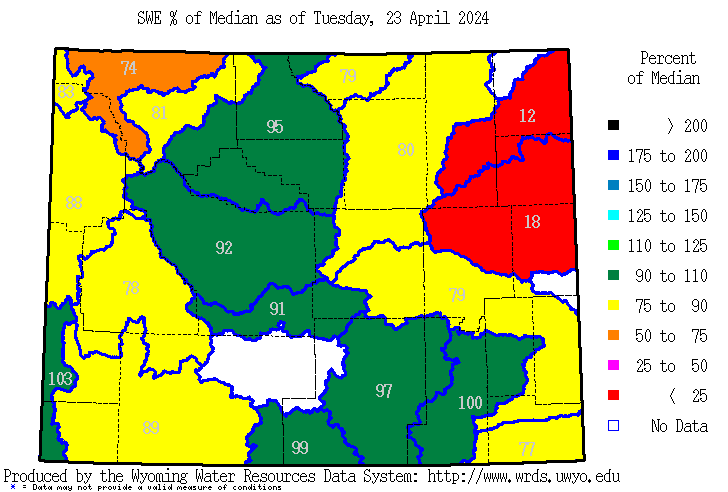
Snow Water Equivalent (SWE) Percent of Median |
Click Image To Enlarge The Upper Green River Basin Snow Water Equivalent (SWE) or the Amount of Water Still Contained in the Snow Pack that has yet to enter the river. Observed (red line) with forecast (multi-colored lines represent several different model solutions) The median SWE amount is represented by the black line going through the gray shaded area. |
 |
 |
|
Click Image To Enlarge The Lower Green River Basin Snow Water Equivalent (SWE) or the Amount of Water Still Contained in the Snow Pack that has yet to enter the river. Observed (red line) with forecast (multi-colored lines represent several different model solutions) The median SWE amount is represented by the black line going through the gray shaded area. |
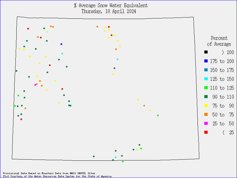
Click Image To Enlarge Individual SNOTEL Site SWE available in the Monitoring and Reporting Section Click here to interrogate all Wyoming SNOTEL sites. |
|
|
|
|
|
|
|
|
|
WY Hydro Summary |
|
|
|
|
So what do we look for when trying to forecast a snowmelt flood event?
1. A significant high elevation rain event
2. A significant warm up (over 70 degrees in the low elevations for 3 or more days) with temperatures remaining above 40 degrees in the mountains at night
3. A cold spring that holds onto the snow pack well into late May or early June (this is what happened in 2011) |
 |
 |
|
Click Image To Enlarge Day 1 Precipitation |
Click Image To Enlarge Day 1 & 2 Precipitation |
 |
 |
|
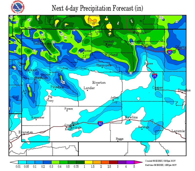
Click Image To Enlarge Days 1-3 Precipitation |
Click Image To Enlarge Day 1-4 Precipitation |
 |
 |
|
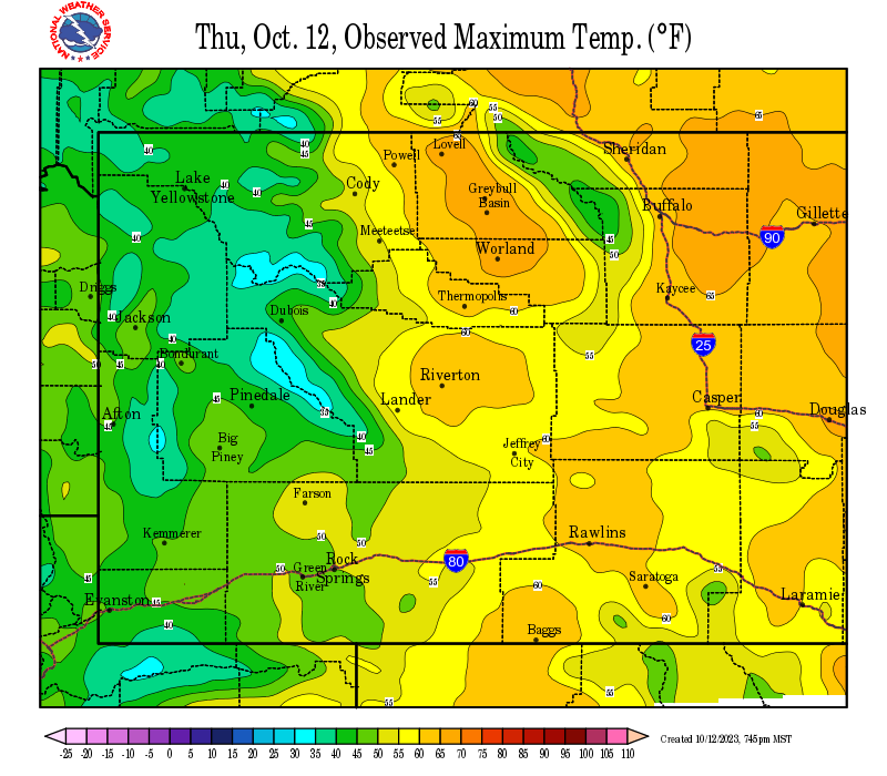
Click Image To Enlarge Yesterday's Observed High Temperature |
Click Image To Enlarge Day 1 High Temperature Forecast |
 |
 |
|
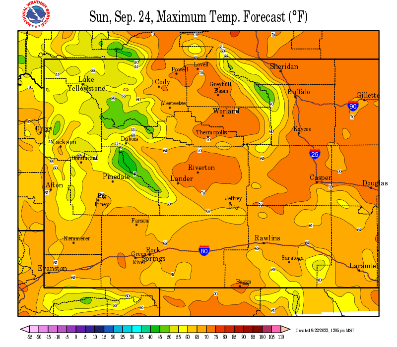
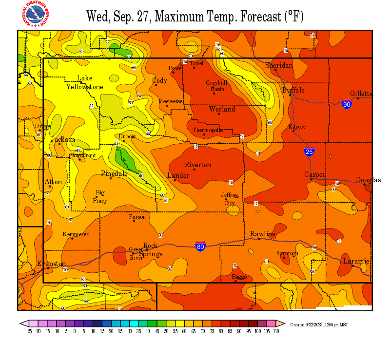
Click Image To Enlarge Day 2 High Temperature Forecast |
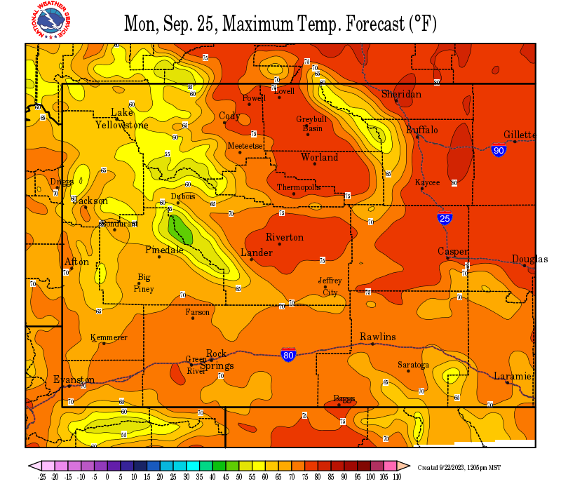
Click Image To Enlarge Day 3 High Temperature Forecast |
 |
 |
|
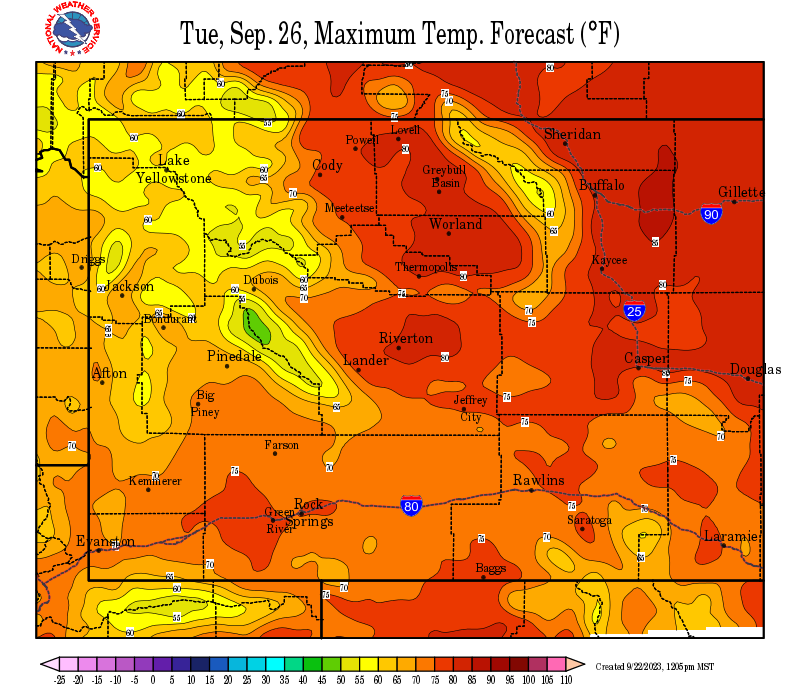
Click Image To Enlarge Day 4 High Temperature Forecast |
Click Image To Enlarge Day 5 High Temperature Forecast |
Please continue to call/send us your photos, and don't forget to monitor our Facebook page and Twitter feed for the latest on ongoing or potential flooding.
Click here for more resources.
|
|
Click Image To Enlarge Gros Ventre Summit SNOTEL Data
|
Click Image To Enlarge Little Warm SNOTEL Data
|
|
Click Image To Enlarge East Rim Divide SNOTEL Data |
Click Image To Enlarge Loomis Park SNOTEL Data |
|
Click Image To Enlarge Kendall SNOTEL Data
|
Click Image To Enlarge New Fork Lake SNOTEL Data |
|
Click Image To Enlarge Elkhart Park SNOTEL Data
|
Click Image To Enlarge Big Sandy Opening SNOTEL Data |
|
Click Image To Enlarge Blind Bull Summit SNOTEL Data |
Click Image To Enlarge Triple Peak SNOTEL Data |
|
Click Image To Enlarge Snider Basin SNOTEL Data |
 |
 |
|
Click Image To Enlarge
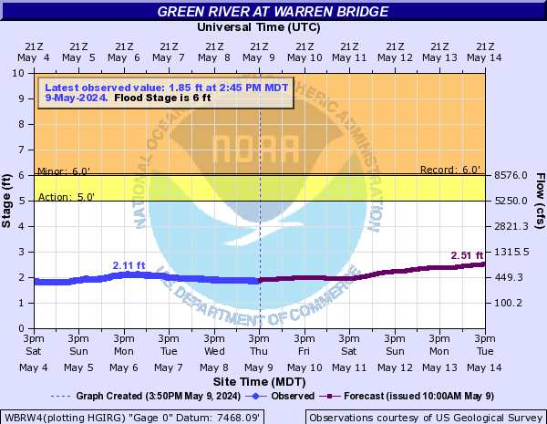
River Gauge Locations in Sublette County |
Click Image To Enlarge Real time gauge reading at the Green River at Warren Bridge (click this link to go to AHPS Page) |
 |
 |
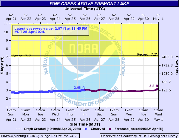
| Click Image To Enlarge
Real time gauge reading at Pine Creek Above Fremont Lake |
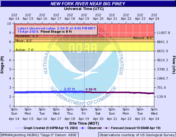
Click Image To Enlarge Real time gauge reading at the New Fork River Near Big Piney |
 |
|
|
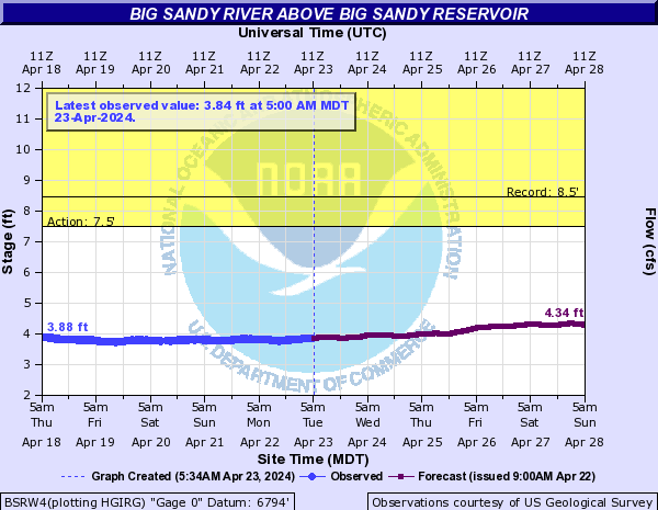
Click Image To Enlarge Real time gauge reading at Big Sandy Reservoir |
|
|
|
|
|
|
|
|
|
|
|
|
 |
Monitor our Severe Weather Summary Page for current Warnings, Watches, and Advisories. What's the difference? |
 |
Check the latest Weather Story graphic for an overview of the area forecast. |
 |
Check out what's on the radar. Riverton | Pocatello | Cheyenne | Billings | Salt Lake City | Rapid City | Mosaic |
 |
Submit storm reports/images and keep up to date with us on Facebook! |
 |
Submit storm reports/images and keep up to date with us on Twitter! |
 |
Other reporting methods include eSpotter, email (cr.wxriw@noaa.gov), or by phone at 1-800-211-1448. |
 |
Check the latest Public Information Statement for the latest storm reports. |
 |
Monitor current road conditions by visiting the Wyoming Dept. of Transportation (WYDOT) or by calling 5-1-1. |
| Here's some informative tips from the Washakie County Sheriff's Office and Worland Police Department about reentering a home that has been flooded. Saturday March 8th, 2014 1:00 p.m. Emergency Personnel have been working closely with Public Health Response Coordinator Kami Neighbors, who has provided us information in regards to post flood and contamination concerns. I will attach that information to this post. It is very important that if anyone is currently using a well for consumption use (in the flood areas), they must first have their water tested. Please contact Kami Neighbors for testing at (307)431-2446 or at Public Health Office at (307)347-3278. Reentering Your Flooded Home When returning to a home that’s been flooded, be aware that your house may be contaminated with mold or sewage, which can cause health risks for your family. When You First Reenter Your Home • If you have standing water in your home and can turn off the main power from a dry location, then go ahead and turn off the power, even if it delays cleaning. If you must enter standing water to access the main power switch, then call an electrician to turn it off. NEVER turn power on or off yourself or use an electric tool or appliance while standing in water. • Have an electrician check the house’s electrical system before turning the power on again. Dry Out Your House If flood or storm water has entered your home, dry it out as soon as possible. Follow these steps: • If you have electricity and an electrician has determined that it’s safe to turn it on, use a “wet-dry” shop vacuum (or the vacuum function of a carpet steam cleaner), an electric-powered water transfer pump, or sump pump to remove standing water. If you are operating equipment in wet areas, be sure to wear rubber boots. • If you do not have electricity, or it is not safe to turn it on, you can use a portable generator to power equipment to remove standing water. Note: If you must use a gasoline-powered pump, generator, pressure washer, or any other gasoline-powered tools to clean your home, never operate the gasoline engine inside a home, basement, garage, carport, porch, or other enclosed or partially enclosed structures, even if the windows and doors are open. Such improper use can create dangerously high levels of carbon monoxide and cause carbon monoxide poisoning. • If weather permits, open windows and doors of the house to aid in the drying-out process. • Use fans and dehumidifiers to remove excess moisture. Fans should be placed at a window or door to blow the air outwards rather than inwards, so not to spread the mold. • Have your home heating, ventilating, and air-conditioning (HVAC) system checked and cleaned by a maintenance or service professional who is experienced in mold clean-up before you turn it on. If the HVAC system was flooded with water, turning on the mold-contaminated HVAC will spread mold throughout the house. Professional cleaning will kill the mold and prevent later mold growth. When the service determines that your system is clean and if it is safe to do so, you can turn it on and use it to help remove excess moisture from your home. • Ensure that crawl spaces in basements have proper drainage to limit water seepage. Ventilate to allow the area to dry out. Inside the Home • Keep children and pets out of the affected area until cleanup has been completed. • Wear rubber boots, rubber gloves, and goggles during cleanup of affected area. • Remove and discard items that cannot be washed and disinfected (such as, mattresses, carpeting, carpet padding, rugs, upholstered furniture, cosmetics, stuffed animals, baby toys, pillows, foam-rubber items, books, wall coverings, and most paper products). • Remove and discard drywall and insulation that has been contaminated with sewage or flood waters. • Thoroughly clean all hard surfaces (such as flooring, concrete, molding, wood and metal furniture, countertops, appliances, sinks, and other plumbing fixtures) with hot water and laundry or dish detergent. • Help the drying process by using fans, air conditioning units, and dehumidifiers. • After completing the cleanup, wash your hands with soap and warm water. Use water that has been boiled for 3 minutes (allow the water to cool before washing your hands). o Or you may use water that has been disinfected for personal hygiene use (solution of â�� teaspoon [~0.75 milliliters] of household bleach per 1 gallon of water). Let it stand for 30 minutes. If the water is cloudy, use a solution of ¼ teaspoon (~1.5 milliliters) of household bleach per 1 gallon of water. • Wash all clothes worn during the cleanup in hot water and detergent. These clothes should be washed separately from uncontaminated clothes and linens. • Seek immediate medical attention if you become injured or ill. Gabe R. Elliott Worland Police Department |
 |
Learn more about the National Weather Service's efforts to build a Weather-Ready Nation! |