National Weather Service United States Department of Commerce

Heavy Rain Return to the Southwest U.S.; Potential Atlantic Tropical System Interaction

Heavy to excessive rainfall from monsoon thunderstorms may bring isolated flash and urban flooding to the Desert Southwest into Sunday. The tropical wave (AL94) continues to bring heavy rainfall to Puerto Rico and the US Virgin Islands. The close proximity of Tropical Storm Humberto and AL94 could lead to interaction between them, but details of their track and intensity forecasts remain uncertain Read More >

Links | Map | Current Warnings, Radar, and Satellite | SPC Fire and Thunder Forecasts
| Fuels and Fire Danger Maps


Fire Weather Banner
Useful Links
Riverton Spot Request Page
Wyoming Inciweb Page
WFO Riverton Fire Weather Page
Fire Weather Planning Forecast
 
Rock Creek near Buffalo 12NW Weather Obs Story Weather Obs Buffalo Airport Weather Obs Mesonet OBS Display FIRE WX Analysis 3 hrly tabular forecast Spot Forecasts Area Forecast Discussion Ntl Fire Wx Page

View Twin Peaks Fire in a larger map


Current Warnings, Radar, and Satellite


What Do the Colors Mean?


Most Recent Fire Weather Watch/Red Flag Warning Text

Please click on the map to see the latest watch and warning products. Click on the first link for the complete color code for public products - some are similar to the Fire Weather colors. In addition, other products highlighted on this map may be important to fire users.

Northern Rockies
Riverton
Billings


Visible
Infrared
Latest Fronts


Loop
Loop
 
Additional Satellite and Fire Resources


 Top


Storm Prediction Center Critical Fire Areas and Thunderstorm Forecasts


All Graphics


Day 1-Critical Fire Areas
Day 2-Critical Fire Areas
Days 3-8 Critical Fire Areas


Current Watches
Current Mesoscale Discussions
Day 1 Categorical Thunder


 Day 1 Tornado
Day 1 Hail
Day 1 Wind


Day 2 Categorical
Day 2 Probabilistic
Day 3 Categorical
Day 3 Probabilistic
Days 4-8 Probabilistic


Thunderstorm Probability Forecasts (Updated Hourly)


Hour 1-3
Hour 4-6
Hour 7-9
Hour 9-11
Hour 11-13
 
Hour 15-17
Hour 17-19
Hour 19-21
Hour 21-23
Hour 23-25


Top                                                              


USFS Fire Danger Graphics and Fuels


All Graphics


Observed Fire Danger Class
Forecast Fire Danger Class
Observed Haines Index
Fire Danger Today
Fire Danger Tomorrow
Current Haines Index


Burning Index
Spread Component
Ignitiion Component
Energy Release Component


1 Hr. Fuel Moisture
10 Hr. Fuel Moisture
100 Hr. Fuel Moisture
1000 Hr. Fuel Moisture


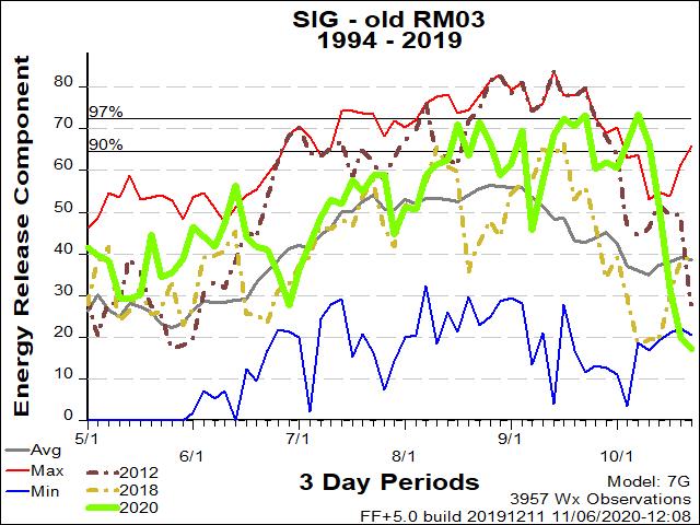
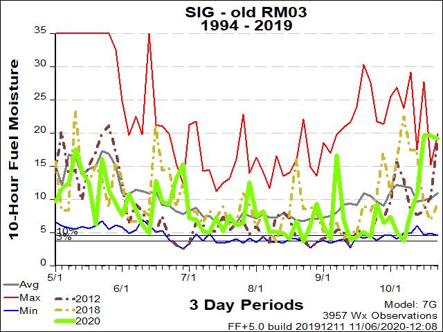
Rocky Mountain Sec. 3 ERC Fuels Graph
Rocky Mountain Sec. 3 10hr. Fuels Graph
Bighorn National Forest Pocket Card
ERC
10 Hour Fuels
Pocket Card


Top


Return to NWS Riverton Homepage

The National Weather Service
Building a Weather-Ready Nation