
Dangerous, record-breaking heat will intensify across most of the central and eastern U.S this week. Heat indices will likely exceed 100 degrees. Heat is likely to continue across the eastern U.S. through the Independence Day holiday weekend. Critical fire weather conditions will continue today and likely Tuesday across portions of the Four Corners and northern High Plains. Read More >

Outlook l Temperature l Precipitation l Conclusion
 |
|
|
El Niño is anchored in the tropical Pacific, but it affects seasonal climate "downstream" in the United States. |
|
 |
 |
|
CPC U.S. Temperature Outlook for the 2018/2019 Winter (Dec-Jan-Feb)
|
CPC U.S. Precipitation Outlook for the 2018/2019 Winter (Dec-Jan-Feb)
|
Summary:
Climate forecasters at the Climate Prediction Center predict a weak El Niño to occur during the meteorological winter months of 2018-2019 (Dec-Jan-Feb). This combined with other global factors should favor Above Normal Temperatures across Wyoming with the greatest chance across northwest and north central Wyoming. Below Normal Precipitation is favored across northern Wyoming during the winter months, and the rest of the state has equal chances of above normal, below normal or normal precipitation; in other words, no clear climate signal. Things to keep in mind, and that were stated in the video above, displayed on these outlooks are the highest probability outlooks. Scroll to each category below to see additional details.

Outlook l Temperature l Precipitation l Conclusion
|
CPC U.S. Temperature Outlook for the 2018/2019 Winter (Dec-Jan-Feb) |
|||
 |
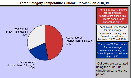
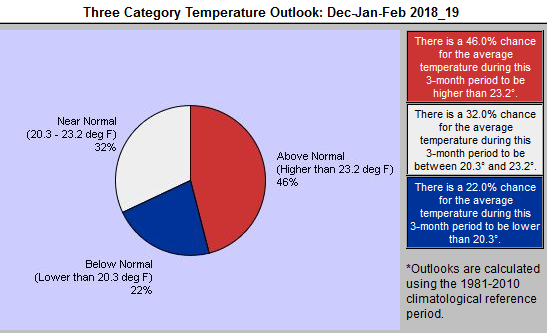
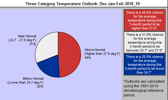
| Jackson | Rock Springs | Cody | Casper |
 |
 |
 |
 |
| More Local 3-month temperature outlooks can be found here | |||
Summary:
With a weak El Niño expected, generally above normal temperatures are favored. There still could be cold temperatures at times. The images above (click to enlarge) show the individual break down by category for temperatures across west and central Wyoming. Overall there is a 45 to 50% chance of above normal temperatures (highest chances across northwest Wyoming), with some slight chances for near and below normal temperatures during the time period.

Outlook l Temperature l Precipitation l Conclusion
|
|
CPC U.S. Precip Outlook for the 2018/2019 Winter (Dec-Jan-Feb)
|
Summary:
The precipitation comes with slightly lower confidence due to variability in El Niño years. A strong El Niño does typically bring below normal precipitation across northwest Wyoming. However, some moderate to weak El Niño years have brought near to above normal precipitation in northwest Wyoming. The map above shows this winter leaning slightly towards below normal chances of precipitation across northern Wyoming , while there are equal chances of above, below or near normal precipitation (no clear climate signal) across the southern two-thirds of Wyoming.

Outlook l Temperature l Precipitation l Conclusion
|
|
|
CPC U.S. Temperature Outlook for the 2018/2019 Winter (Dec-Jan-Feb)
|
CPC U.S. Precipitation Outlook for the 2018/2019 Winter (Dec-Jan-Feb)
|
Key Points

