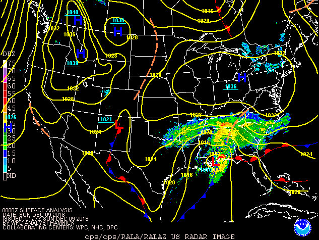
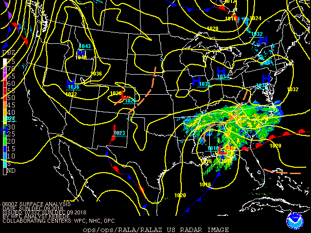
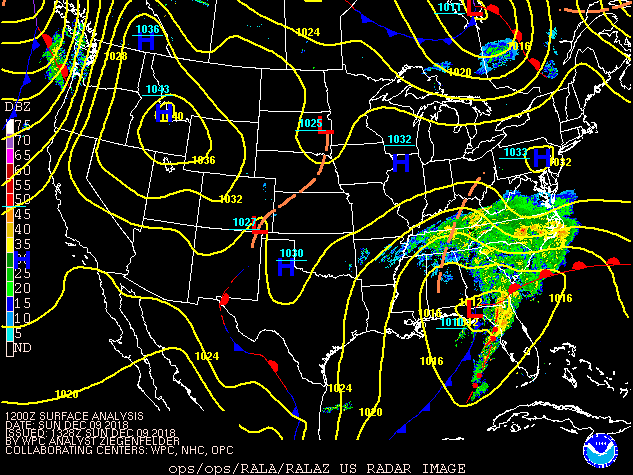
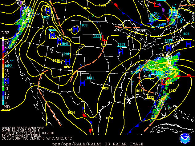
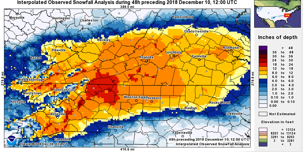
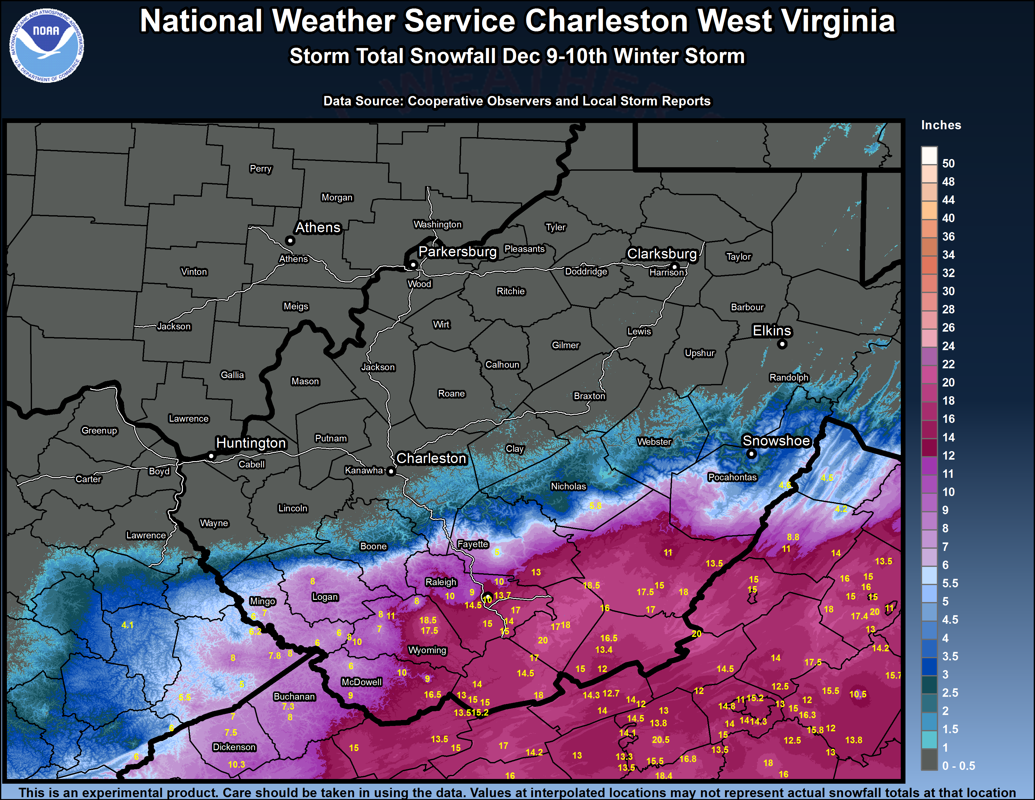
A low pressure system tracking across the Deep South produced a heavy early winter snowfall across the southern Appalachians from Saturday night December 8th through Sunday December 9th. The resulting snowfall was noteworthy due to the snowfall amounts, which approached 20 inches in some locations, and the tight snowfall gradient on the northern fringe of the precipitation shield.
Storm Setup and Snowfall Gradient
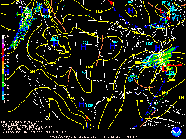
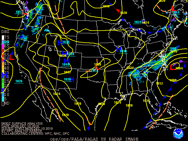
A wintry mix of precipitation began to spread into southwest Virginia during Saturday evening December 8th. The precipitation quickly changed to snow and became heavy as it spread to the north into southern West Virginia Sunday morning December 9th. Strong high pressure and a very dry airmass in place to the north put a halt to the northward extent of the snow, however, and while heavy snow fell over southern West Virginia, hardly any snow fell from Charleston north.
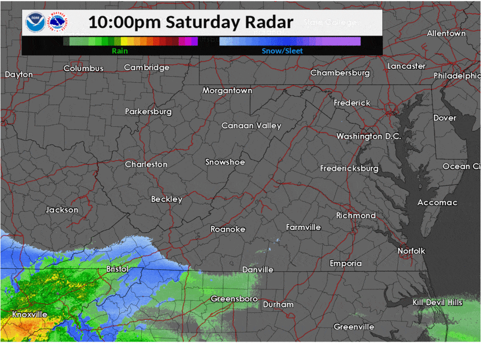 |
Talk about a sharp snow gradient on the north side of this winter storm -- check out these two @WV511 cams near Beckley, WV! @WVDOT pic.twitter.com/FEKA2HKHl7
— NWS Charleston, WV (@NWSCharlestonWV) December 9, 2018
Snowfall Totals
Snowfall totals ranged from near nothing in Charleston upwards to a foot in Beckley. Additional amounts up to 20 inches occurred in Monroe County near Alderson. Below is a map of the event along with a summary of reports in the NWS Charleston, WV service area.
 |
The following are unofficial observations summarizing heavy snowfall
experienced across southern West Virginia and southwest Virginia.
Appreciation is extended to emergency management, highway departments,
cooperative observers, Skywarn spotters and media for these reports.


********************STORM TOTAL SNOWFALL********************

LOCATION       STORM TOTAL     TIME/DATE   COMMENTS
                  SNOWFALL            OF
                  /INCHES/   MEASUREMENT


WEST VIRGINIA

...Boone County...
Havana                 1.0   652 PM 12/09  Trained Spotter

...Fayette County...
Layland               13.0   847 PM 12/09  Public
Oak Hill               5.0   705 PM 12/09  Social Media
Hawks Nest State Par   2.0   700 AM 12/10  Co-Op Observer

...Greenbrier County...
2 E Lawn              18.5   800 PM 12/09
Alderson              18.0   800 PM 12/09
White Sulphur Springs 18.0   900 PM 12/09
Lewisburg             17.5  1028 AM 12/10
Organ Cave            17.0   800 PM 12/09
3 S Maxwelton         15.0   815 PM 12/09
3 SSW Neola           13.5   743 PM 12/09
Rainelle              12.0   700 PM 12/09
Renick                11.0   800 PM 12/09
Neola                  9.0   800 PM 12/09

...Kanawha County...
1 E South Charleston   0.3   800 AM 12/10  CoCoRaHS

...Logan County...
Logan                  8.0   557 PM 12/09  Dept of Highways
Man                    4.0   700 AM 12/10  Co-Op Observer

...McDowell County...
Anawalt               16.5   944 PM 12/09  Public
Pageton               12.5   800 PM 12/09  Social Media
Eckman                 9.0   700 PM 12/09  Social Media
Jolo                   9.0   324 PM 12/09  Social Media
Gary                   7.3   708 PM 12/09  Social Media

...Mercer County...
Oakvale               18.0   953 PM 12/09
Lerona                17.0  1047 AM 12/10
Bluewell              15.0  1032 AM 12/10
1 NNW Athens          14.5   637 PM 12/09
2 NNE Montcalm        14.0  1045 PM 12/09
Bramwell              13.0   920 PM 12/09
Bluefield             12.2   700 AM 12/10  COOP

...Mingo County...
1 W Delbarton          7.0   720 PM 12/09  Social Media
Gilbert                6.0   640 PM 12/09  Social Media
Wharncliffe            6.0   621 PM 12/09  Social Media
1 NNE Williamson Ter   6.0   700 PM 12/09  Social Media

...Monroe County...
2 SSE Sweet Springs   20.0  1034 AM 12/10
3 E Wayside           16.5  1000 PM 12/09
Alderson              16.0   800 AM 12/10   COOP
3 S Red Sulphur Sprg  15.0   400 AM 12/10
Lindside              12.0   713 PM 12/09

...Nicholas County...
9 W Richwood           5.8   700 AM 12/10  CoCoRaHS
1 N Craigsville        1.5   700 AM 12/10  CoCoRaHS

...Pocahontas County...
Frost 3ne              4.6   640 AM 12/10  Co-Op Observer
Snowshoe               4.0   600 AM 12/10  Co-Op Observer
3 SW Marlinton         4.0   700 AM 12/10  IFLOWS
4 SSE Snowshoe         2.8   700 AM 12/10  CoCoRaHS
Bartow                 1.6   730 AM 12/10  Co-Op Observer

...Raleigh County...
Glade Springs         17.0   642 PM 12/09  Social Media
White Oak             16.8   430 PM 12/09  Social Media
Crab Orchard          14.5   533 PM 12/09  Via HAM, NWSChat
Cool Ridge            14.0   520 PM 12/09  Dept of Highways
East Beckley          12.5   445 PM 12/09  Social Media
Beckley               10.5   500 PM 12/09  Social Media
Beckley VA Hospital   10.0   700 AM 12/10  Co-Op Observer
Piney View            10.0   500 PM 12/09  Social Media
Fairdale              10.0   550 PM 12/09  Trained Spotter
1 W Princewick         9.7   420 PM 12/09  Social Media
Harper                 9.0   335 PM 12/09  Social Media
3 SE STANAFORD         6.5   720 PM 12/09  911 Call Center

...Summers County...
3 E Ellison           20.0  1051 AM 12/10
1 ENE Hinton          18.0   651 PM 12/09
3 ESE Hinton          18.0   811 PM 12/09
Bluestone Lake        17.0   730 AM 12/10  COOP

...Wyoming County...
Saulsville            17.5   930 PM 12/09  Public
Oceana                11.0   700 AM 12/10  Co-Op Observer
Lynco                  8.0   320 PM 12/09  Social Media
R.D. Bailey Lake And   8.0   700 AM 12/10  Co-Op Observer


VIRGINIA

...Alleghany County...
3 W Hollins           15.0   720 PM 12/09

...Bland County...
Bland                 17.0   920 PM 12/09
3 SW Long Spur        14.2  1150 PM 12/09

...Buchanan County...
Grundy                 7.3   700 AM 12/10  Co-Op Observer

...Craig County...
3 NE Abbott           14.5   655 PM 12/09

...Dickenson County...
4 SSE Nora            10.3   700 AM 12/10  Co-Op Observer
1 ESE Herald           9.0   607 PM 12/09  Social Media
Clinchco               7.5   614 PM 12/09  Trained Spotter
Clintwood              6.0   618 PM 12/09  911 Call Center

...Giles County...
1 NE Pearisburg       14.3   736 PM 12/09
3 S Mountain Lake     14.0   738 PM 12/09
3 SW Eggleston        14.0   900 AM 12/10
2 SE Mountain Lake    13.2   930 PM 12/09
1 NNE Pembroke        12.7   700 AM 12/10  COCORAHS
Newport               12.0   625 PM 12/09

...Tazewell County...
Richlands             15.0   954 PM 12/09
Burkes Garden         15.0   615 AM 12/10  COOP
Gratton               13.5   932 PM 12/09
2 WNW Bluefield       13.5  1000 PM 12/09


KENTUCKY

...Pike County...
2 SSE Majestic         8.0   400 PM 12/09
Kimper                 8.0   200 PM 12/09
Phelps                 7.8   437 PM 12/09
Hardy                  6.3   500 PM 12/09
1 ENE Jonancy          5.5   500 PM 12/09
3 W Mouthcard          5.0   830 PM 12/09
Canada                 4.0   400 PM 12/09
Marrowbone             4.0   800 PM 12/09
Robinson Creek         2.0   245 PM 12/09
Forecast Uncertainty
The storm system was a very challenging one to forecast as computer models trended southward with the precipitation shield several days out only to trend back northward with the snow shortly before the event began. This uncertainty was highlighted in a social media post by NWS Charleston, WV on Thursday December 6th...
Lots of questions remain on the upcoming weekend storm... here's our latest thoughts on the system. The time frame for impacts starts late Saturday/early Sunday and lasts through Monday, primarily in the southern portions of the area. #swvawx #wvwx pic.twitter.com/4t5tSu2fL2
— NWS Charleston, WV (@NWSCharlestonWV) December 7, 2018
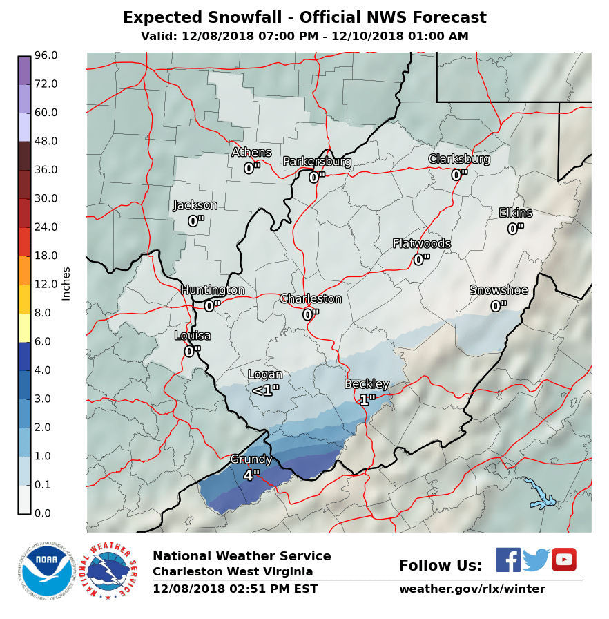
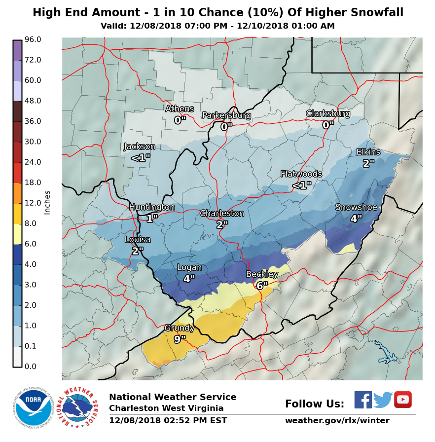
Even as late as Saturday afternoon December 8th, 12 hours before the snow was to begin across much of the affected area, forecast uncertainty was high. The graphics below show our forecast snowfall for the storm (middle) as of Saturday afternoon along with the 10th and 90th percentile probabilities based on a wide ranging suite of computer model guidance, as can be found from our Winter Forecasts/Probabilistic Snowfall webpage. We use the 90th percentile graphic (right) to depict a reasonable upper-end snowfall amount for the time period shown based on many computer model simulations of possible snowfall totals. This higher amount is an unlikely scenario, with only a 1 in 10, or 10% chance that more snow will fall, and a 9 in 10, or 90% chance that less snow will fall. The actual snowfall amounts received in the storm far exceeded this 10th percentile amount in many areas.
 |
 |
 |
 |
Media use of NWS Web News Stories is encouraged! Please acknowledge the NWS as the source of any news information accessed from this site. |
|

