Program Overview
|
The NWS Frost/Freeze program is designed to alert gardeners and growers that actions may be needed to protect tender vegetation from potentially harmful cold temperatures. When a frost or freeze is expected during the local growing season, the NWS will issue a Frost Advisory or Freeze Warning. The “Growing Season” is defined as the period between the average (median) date of the last Spring freeze and the average date of the first Fall freeze. Depending on local weather patterns, the start/end of the growing season may vary each season. Actions in the Spring can help protect young vegetation that is just in its early stages, with actions in the Fall possibly helping to prolong the season. Outside of the growing season, the NWS will not issue any Frost or Freeze headlines, and strongly urges you to follow local forecasts of temperatures and take protective actions if needed. Please click on the tabs below for more information on the current status of the NWS Charleston Frost/Freeze program (including frost/freeze risk maps), criteria delineation, Fall/Spring climatology, temperature forecasts and outlooks, etc. Please note that most images can be expanded by clicking on them. |
Public Information Statement
National Weather Service Charleston WV
241 PM EDT Fri Apr 17 2026

...THE GROWING SEASON BEGINS FOR THE HIGHER ELEVATIONS OF THE MOUNTAINS...

Observations and reports suggest extensive green up is occurring
across the higher elevations of the West Virginia mountains above
2,500 feet in elevation. First bloom has occurred across most of
these areas too due to the abnormally warm temperatures that have
been in place.

As a result, the 2026 growing season has commenced and frost/freeze
headlines will be issued as needed across the higher terrain to
protect vegetation and crops in these areas.
|
 |
 |
Current Status of the NWS Charleston Frost/Freeze Program
*Areas shaded in green indicate where the program is active, while red indicates an inactive program.
Frost/Freeze headlines will not be issued for areas where the program is inactive.
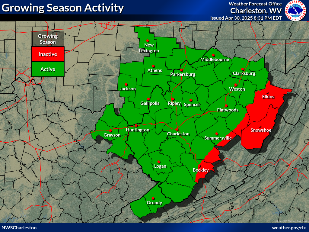
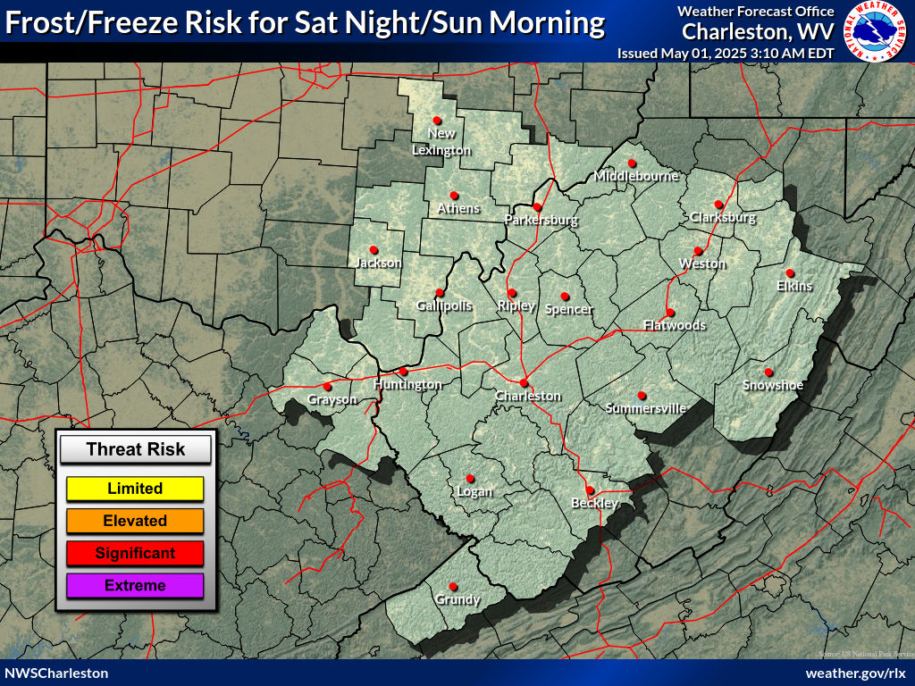
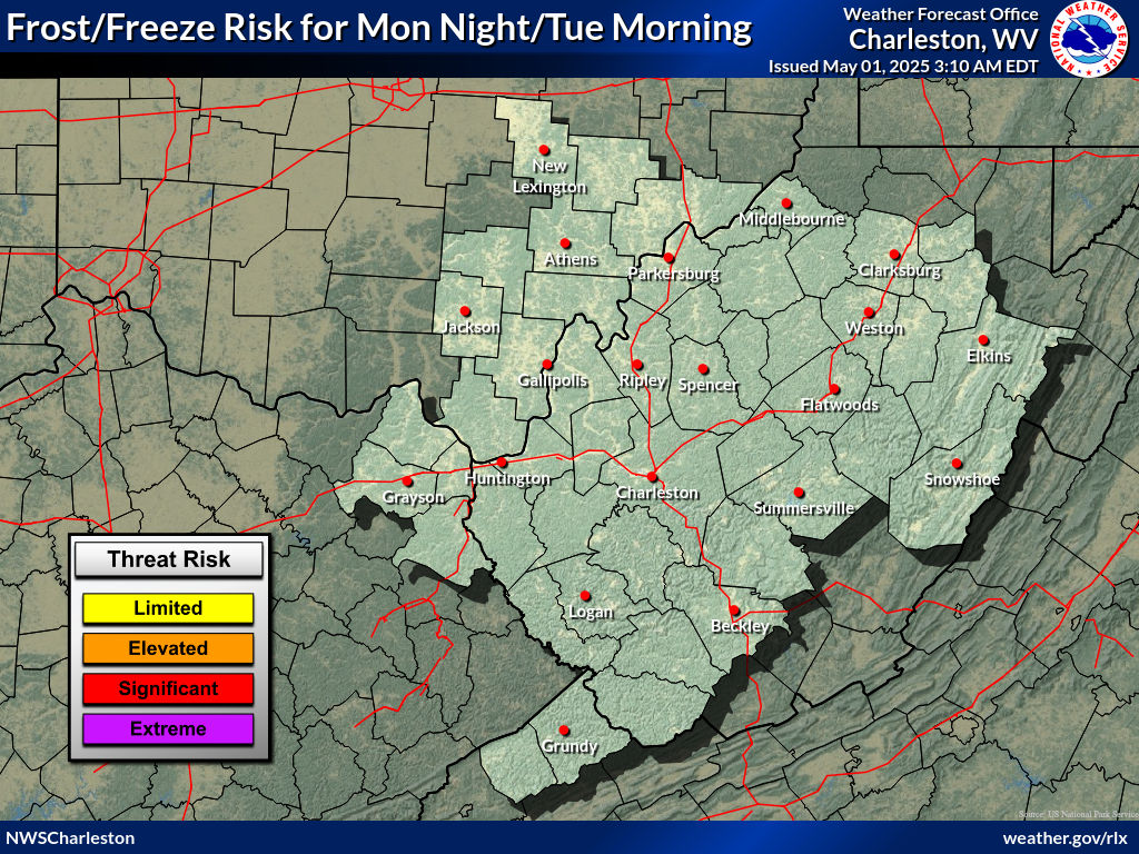
Frost/Freeze Risk Maps for the NWS Charleston Forecast Area
*Frost/Freeze risk levels will only appear in forecast zones where the growing season is currently active.
Days 1-2
 |
 |
Days 3-4
 |
 |
Days 5-6
 |
 |
Local Advisory/Warning Criteria
Do you know what products the National Weather Service issues in terms of frost and freezes? Frost Advisories and Freeze Warnings can help you make decisions about what to do with temperature-sensitive plants at the beginning or near the end of the growing season. Once there is a severe frost or ‘killing freeze’ in the fall, these products are no longer issued until the growing season begins again in the following spring.
Frost Advisory: A Frost Advisory is issued when widespread frost is expected during the locally defined growing season on nights with good radiational cooling conditions (e.g. light winds and clear skies). This usually occurs with minimum temperatures are forecast to be 33°F to 36°F. At least minor damage is possible to sensitive plants or seasonal vegetation in these situations. One must keep in mind that frost is not guaranteed if the air is very dry, sufficient cloud cover is in place, and/or winds are roughly 6+ MPH.
What to do: If a Frost Advisory is issued for your area, move sensitive plants inside or cover them up before the sun sets to help retain heat near them. You may also water the soil as wet soils retain heat better.
Freeze Watch/Warning: A Freeze Warning is issued when minimum temperatures are expected to be 29-32 degrees during the locally defined growing season. A Freeze Watch may be issued a few days ahead of time if the potential exists for temperatures to fall into these thresholds. A freeze will result in significant damage to many unprotected sensitive plants or seasonal vegetation, especially if the temperature remains at-or-below freezing for several hours.
What to do: If a Freeze Warning is issued for your area, cover up plants before the sun sets in order to help retain heat near them. You may also water the soil as wet soils retain heat better. If possible, move your plants inside. Depending on the severity of conditions, the freeze will likely kill them.
***Important - Please note that as of Fall 2024, Hard Freeze Watches and Warnings will no longer be issued as part of the National Weather Service Hazard Simplification, but instead will be consolidated into the Freeze Watch/Warning product with enhanced language for hard freeze conditions as needed. This will simplify and improve messaging and service delivery. For more information, please click HERE.***
Hard Freeze Watch/Warning: A Hard Freeze Warning is issued when minimum temperatures are expected to be 28 degrees or less for more than one hour during the locally defined growing season. This usually means that most sensitive plants or seasonal vegetation will be destroyed. In addition, there is the potential of damage to unprotected outdoor plumbing / un-drained sprinkler systems, etc. A Hard Freeze Watch may be issued a few days ahead of time if the potential exists for temperatures to fall into these thresholds. A ‘killing freeze’ refers to a severe frost that will end the growing season, and would be associated with below freezing temperatures of this nature.
What to do: If a Hard Freeze Warning is issued for your area, there is little you can do to protect plants that are left outside as the freeze will likely kill them. If possible, move your plants inside.
The Science Behind Frost Formation
Frost is most likely formed from frozen dew. Dew is commonly formed on clear nights when the winds are calm, soil is moist, and a low dew point depression exists (dew point depression is the difference in air temperature and dew point temperature). Local terrain can also have a significant effect on the location of frost formation.
Frost can form in two ways. One way frost can form is when the dew point (frost point) dips below freezing. In this form, water vapor skips the liquid state, and goes directly to the solid state. This frost can resemble a light snowfall if thick enough, and usually covers vegetation, cars, roofs, etc. The other way frost forms is from frozen dew. This comes from the freezing of liquid water. This will occur when both dew point and air temperatures are above freezing, and due to radiational cooling, are brought down to the freezing point.
Frost can occur at above freezing temperatures because NWS temperature observations are taken at an elevation of five feet above ground level. Cold air sinks, so the coldest air will be near ground level, with near surface air temperatures potentially being several degrees colder than what is being measured at standard NWS observation sites. This, of course, would be on clear and calm nights when mixing of the air is less likely to occur, and radiative cooling is maximized.
As stated earlier, local terrain can have an effect on the location of where frost can form. This will be found most common in valleys. Because valleys sit at a lower elevation than surrounding mountains or peaks, and cold air sinks due to its higher density, there will be a higher chance of frost in said valleys where the coldest temperatures exist. Valleys are also sheltered from winds, making conditions more favorable for frost to form.
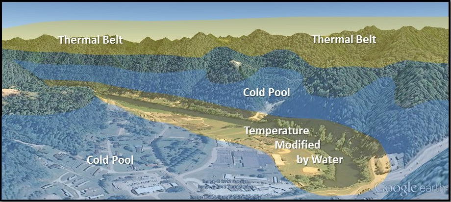
Classic depiction of cold air drainage across a river valley on a clear and calm fall/spring night. Cold, dense air will sink into the valleys facilitating dew and eventually frost to form when temperatures allow. In river valleys, warmer water from the river modifies the air temperature in nearby locations, potentially reducing the chance of frost forming, particularly during the fall season.
NWS Charleston Frost/Freeze Climatology
* Fall/Spring Seasonal Normals are based on the 1991-2020 U.S. Climate Normals (NCEI) *
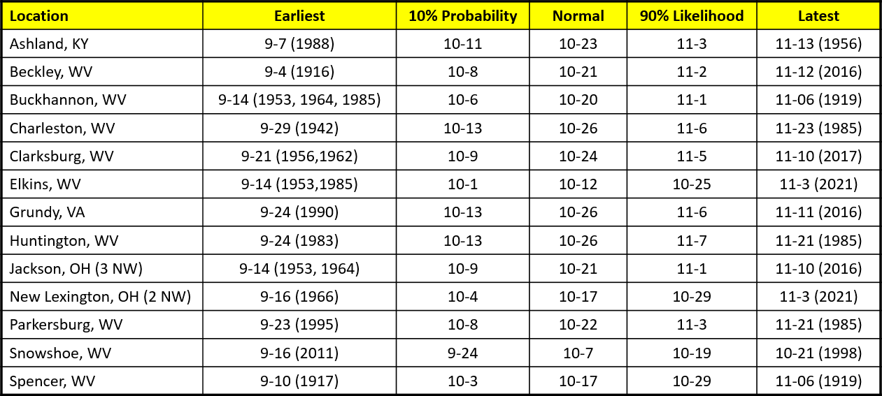
First Fall Temperature ≤ 36 °F ("Frost") for Select Locations
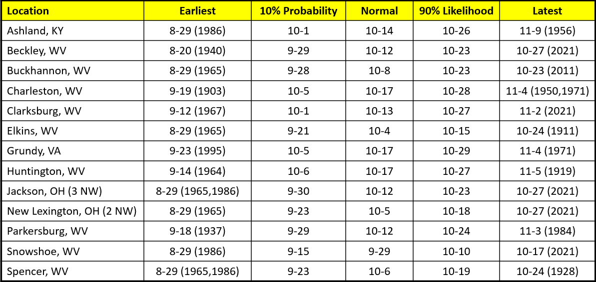
* 10% Probability shows the date by which the first 36 degree temperature will occur in 10 percent of the years. This would represent an unusually early date for the minimum temperature to be ≤ 36 °F.
* 90% Likelihood shows the date by which the first 36 degree temperature will occur in 90 percent of the years. In other words, the first temperature ≤ 36 °F almost always occurs by these dates.
* Earliest/latest fall temperature data is based on a time-frame that encapsulates August 1st to November 30th.
First Fall Temperature ≤ 32 °F ("Freeze") for Select Locations
* 10% Probability shows the date by which the first 32 degree temperature will occur in 10 percent of the years. This would represent an unusually early end to the growing season.
* 90% Likelihood shows the date by which the first 32 degree temperature will occur in 90 percent of the years. In other words, the first freezing temperature almost always occurs by these dates.
* Earliest/latest fall temperature data is based on a time-frame that encapsulates August 1st to November 30th.
Last Spring Temperature ≤ 36 °F ("Frost") for Select Locations
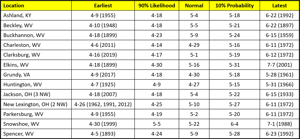
* 10% Probability shows the date after which the last 36 degree temperature will occur in 10 percent of the years. This would represent an unusually late date for the minimum temperature to be ≤ 36 °F.
* 90% Likelihood shows the date after which the last 36 degree temperature will occur in 90 percent of the years. In other words, the last temperature ≤ 36 °F almost always occurs after these dates.
* Earliest/latest spring temperature data is based on a time-frame that encapsulates March 1st to July 31st.
Last Spring Temperature ≤ 32 °F ("Freeze") for Select Locations
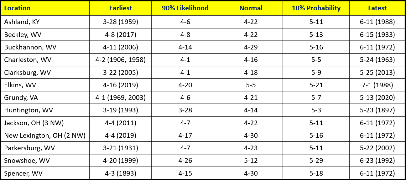
* 10% Probability shows the date after which the last 32 degree temperature will occur in 10 percent of the years. This would represent an unusually late start to the growing season.
* 90% Likelihood shows the date after which the last 32 degree temperature will occur in 90 percent of the years. In other words, the last freezing temperature almost always occurs after these dates.
* Earliest/latest spring temperature data is based on a time-frame that encapsulates March 1st to July 31st.
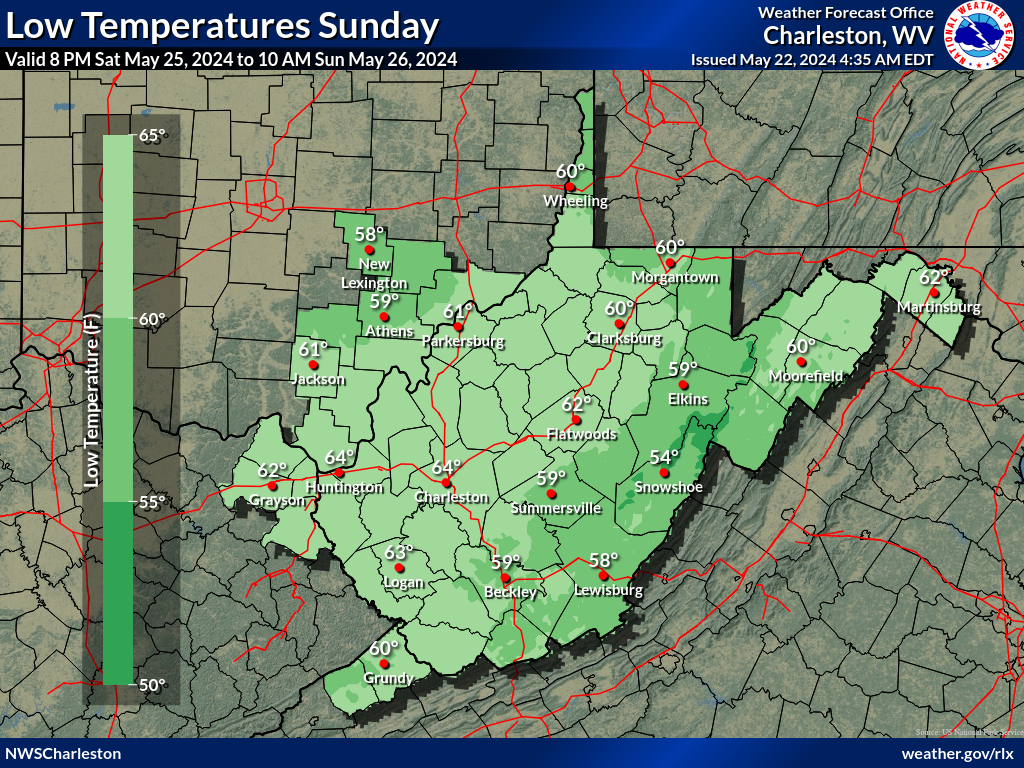
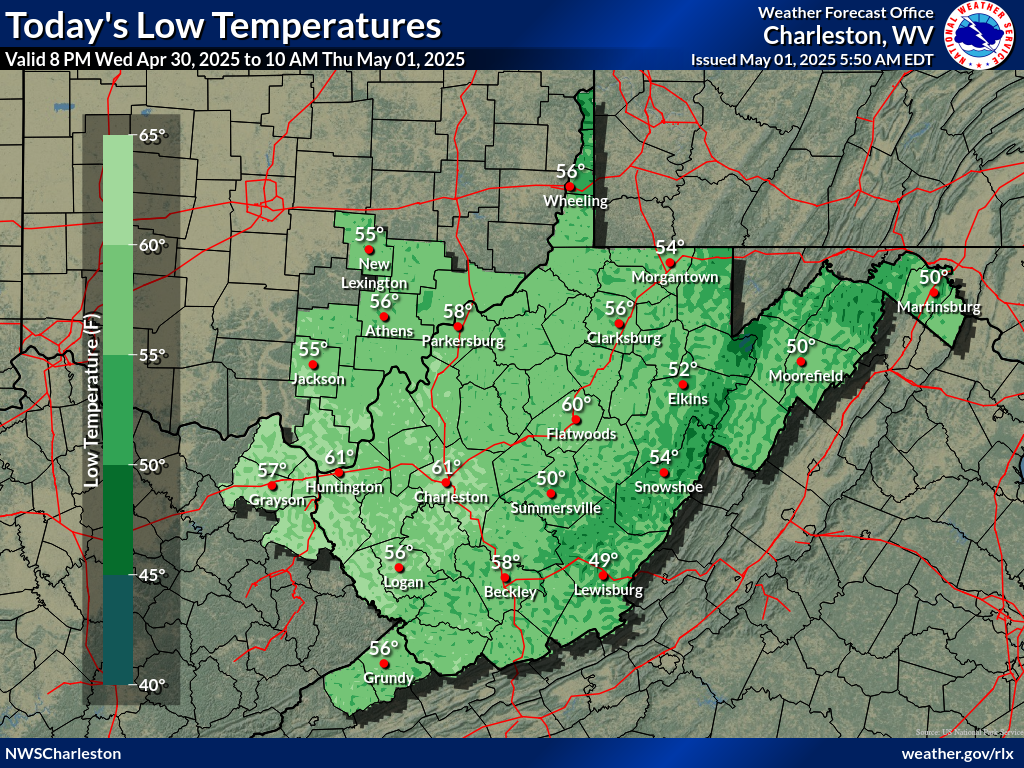
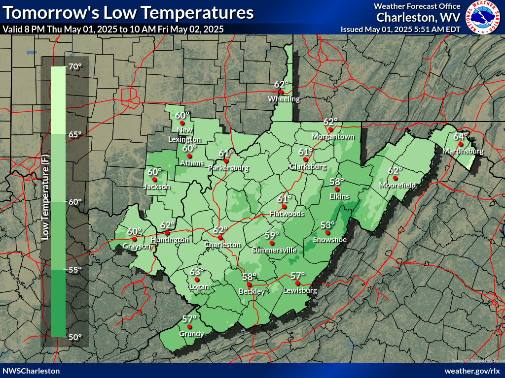
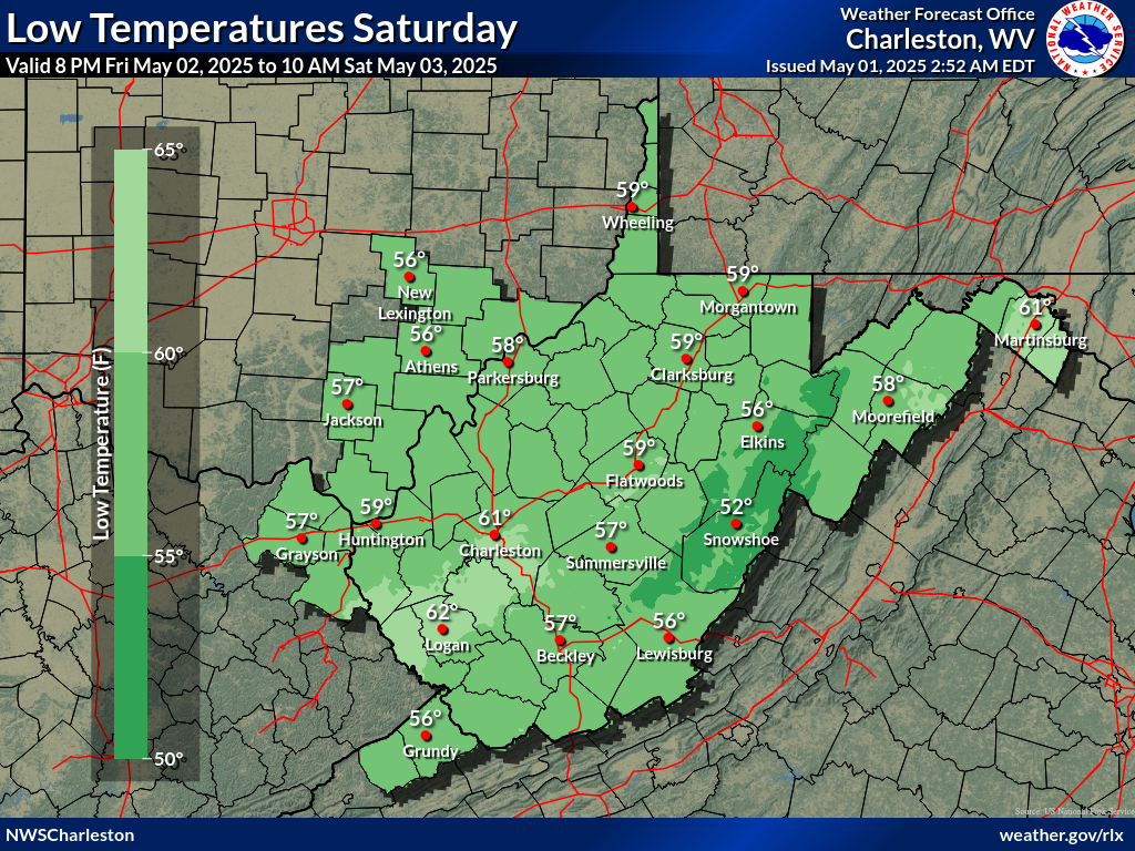
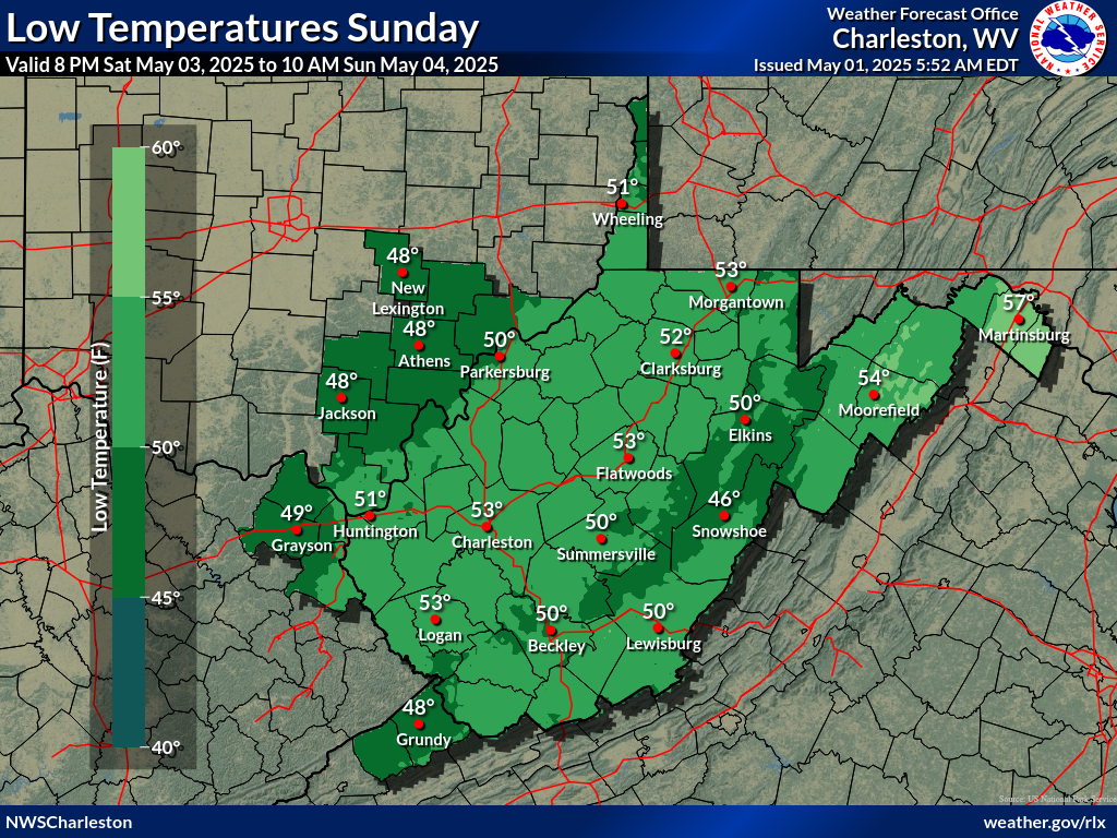
Low Temperature Forecast (Days 1-5)
|
|
 |
 |
|
|
Climate Prediction Center (CPC) Temperature Outlooks
 |
 |
|
Image courtesy of The Climate Prediction Center (CPC) |
Image courtesy of The Climate Prediction Center (CPC) |
The Climate Prediction Center (CPC) produces temperature outlook maps that update daily between approximately 3 PM to 4 PM. CPC's 6-10 day and 8-14 day temperature maps show the probability of the observed temperature (the average of the daily mean temperature of all the days in the period) will be in one of three different categories: above normal, near normal and below normal. The daily mean temperature is the 24hr average of all temperature observations for a given station on a given day. The 6-10 Day Average and 8-14 Day Average are the average of all the daily mean temperatures within either the 6-10 day period or 8-14 day period. Please see their web page for more details and information.
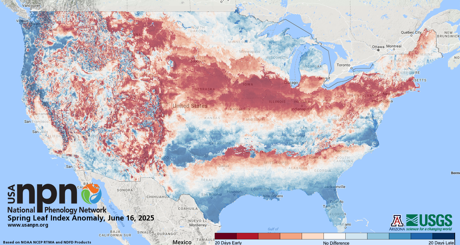
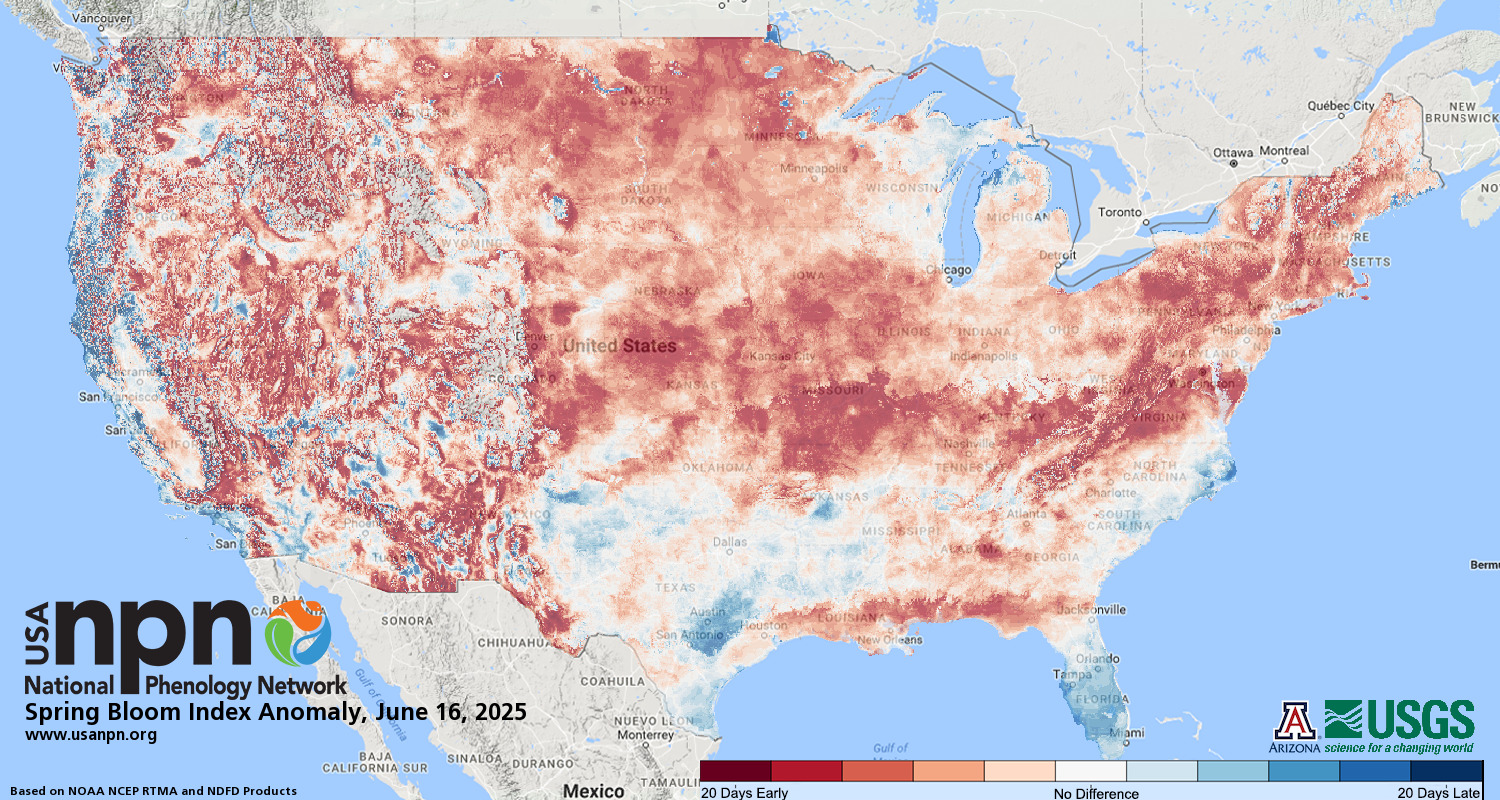
USA National Phenology Network Data
The USA National Phenology Network (USA-NPN) produces several maps that update daily, depicting the progression of particular types of spring vegetation across the nation, and how it compares to long-term averages. The two maps highlighted below depict First Leaf Index Anomaly and First Bloom Index Anomaly. In short, this means they show the status of some types of spring vegetation (first leaf-out or first-flowering) compared to long-term averages, giving an idea of whether spring is "ahead" of or "behind" schedule. Please see their web page for more details and information.
 |
 |
|
Spring Leaf Index Anomaly Image courtesy of The USA National Phenology Network (USA-NPN) |
Spring Bloom Index Anomaly Image courtesy of The USA National Phenology Network (USA-NPN) |
Special thanks to Thomas Witte for creating this webpage during his 2023 Summer Student Volunteership.