Charleston, WV
Weather Forecast Office
 |
 |
 |
| Click to Enlarge | ||
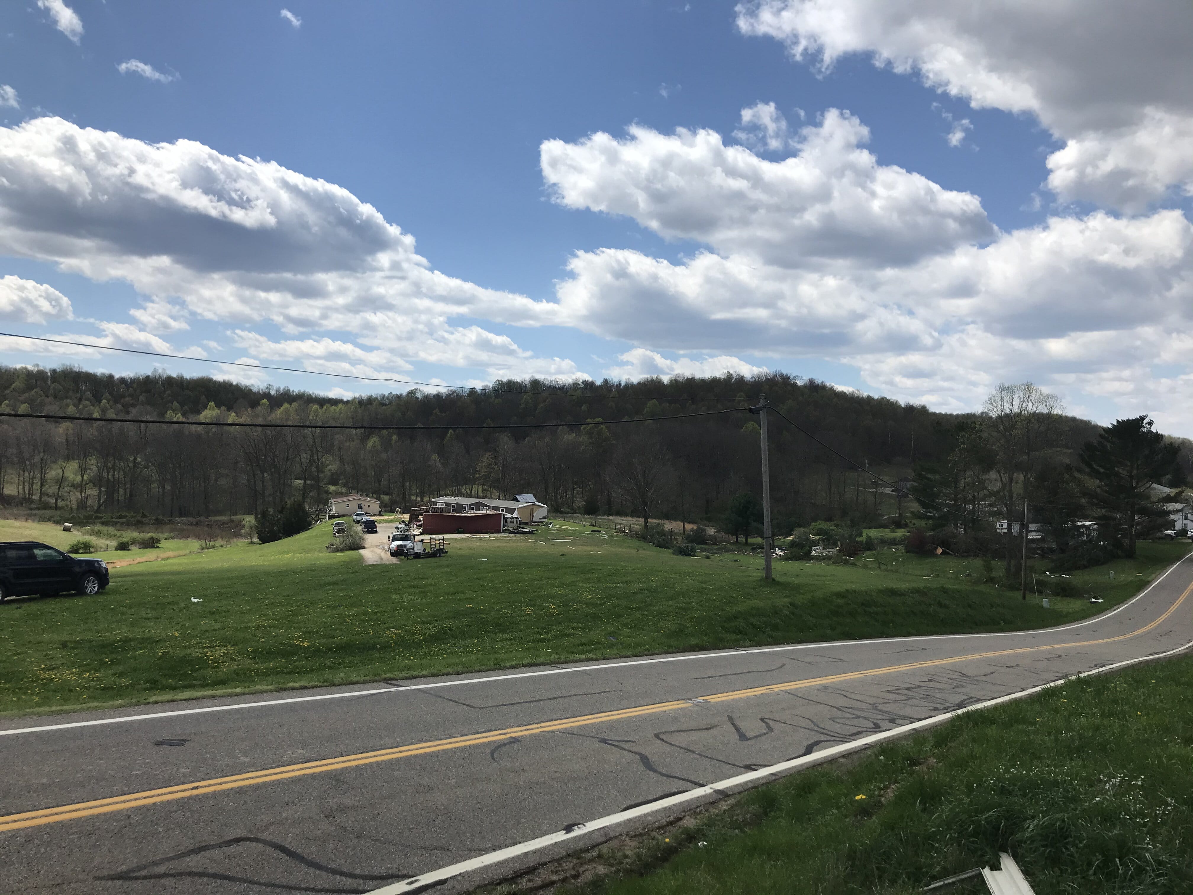
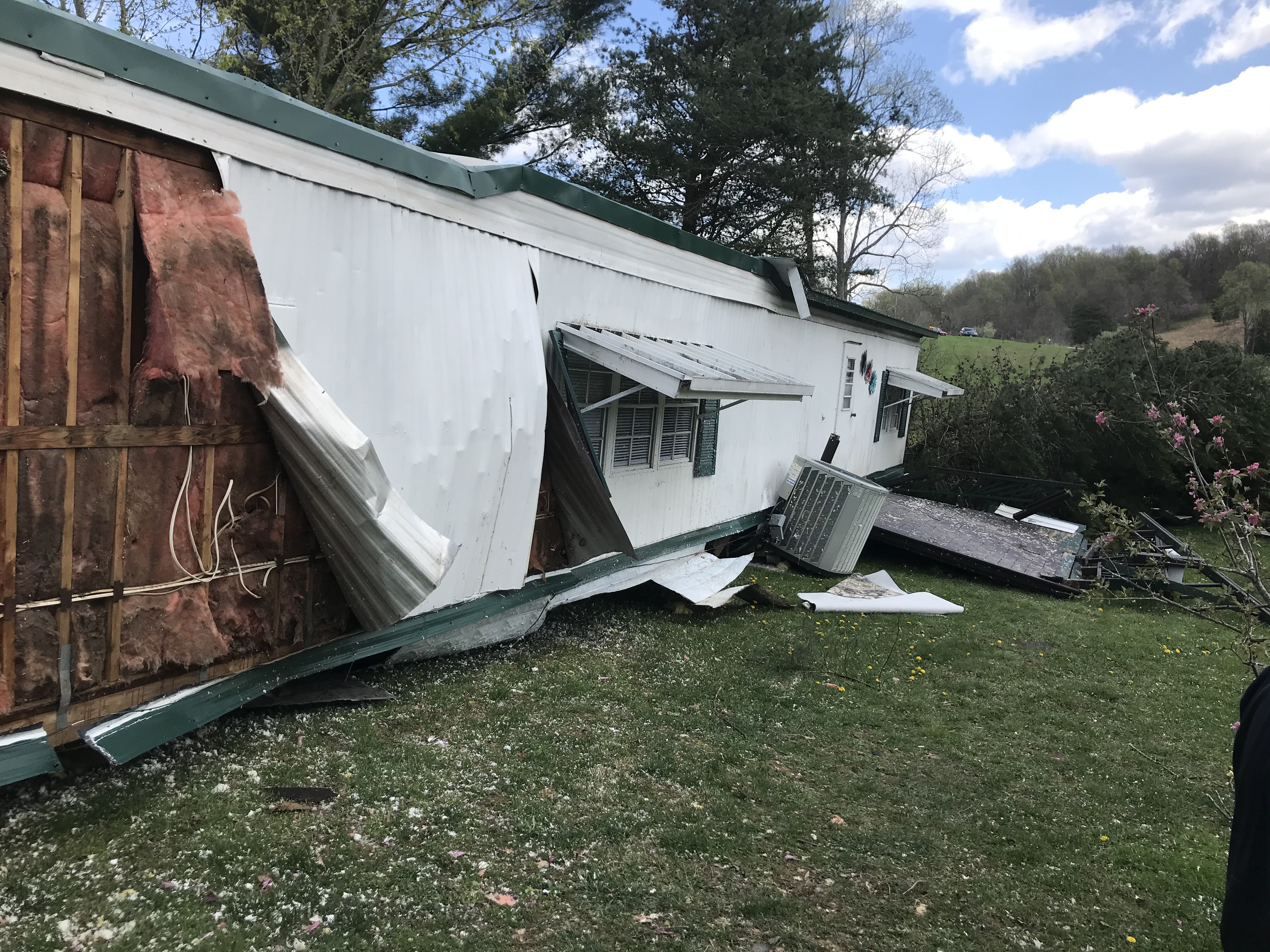
...NWS DAMAGE SURVEY FOR 04/09/20 TORNADO EVENT...

...Vinton County Tornado...

Start Location...2 W Wilkesville in Vinton County OH
End Location...2 W Wilkesville in Vinton County OH
Date...04/09/2020
Estimated Time...12:33 AM EDT
Maximum EF-Scale Rating...EF1
Estimated Maximum Wind Speed...90 mph
Maximum Path Width...125 yards
Path Length...0.25 miles
Beginning Lat/Lon...39.0794 / -82.3565
Ending Lat/Lon...39.0821 / -82.3538
* Fatalities...0
* Injuries...0

...Summary...
Brief tornado touchdown occurred along Ohio 124 1.5 miles WNW of
Wilkesville. A new double-wide mobile home was shifted off the
block foundation and turned in a westerly direction. Nearby, a
garage was destroyed. Another nearby mobile home was blown a few
feet off it`s foundation in a southerly direction. Clear rotation
was also evident in the direction several uprooted trees were
laying and in debris scattered across the property.

EF Scale: The Enhanced Fujita Scale classifies tornadoes into the
following categories:

EF0...Weak......65 to 85 mph
EF1...Weak......86 to 110 mph
EF2...Strong....111 to 135 mph
EF3...Strong....136 to 165 mph
EF4...Violent...166 to 200 mph
EF5...Violent...>200 mph

* The information in this statement is preliminary and subject to
change pending final review of the event and publication in NWS
Storm Data.
Warnings/Hazards
Local Briefing
Report Severe Weather
Winter Storm Severity Index
Hazards Criteria
Heat Risk
Observations
Current Weather Briefing
Observations (List)
Local Radar
Regional Radar
Satellite
Rain Gauge Monitoring
Snowfall Reports
Ice Reports
Local Storm Reports
Public Information Statements
Forecasts
Forecast Discussion
Local Zone Forecast
Graphical Forecasts
Hourly Forecasts
Local Aviation Weather
Local Fire Weather
Winter Weather Forecasts
Probabilistic Rainfall Forecasts
Long Range Outlooks
Rivers and Lakes
River Observations/Forecasts
Ensemble River Guidance
Ensemble Dashboard
River Monitor
Hydrograph Dashboard
River/Lake Summary
US Dept of Commerce
National Oceanic and Atmospheric Administration
National Weather Service
Charleston, WV
1754 Hendrickson Drive
South Charleston, WV 25303
(304) 356-5885
Comments? Questions? Please Contact Us.

