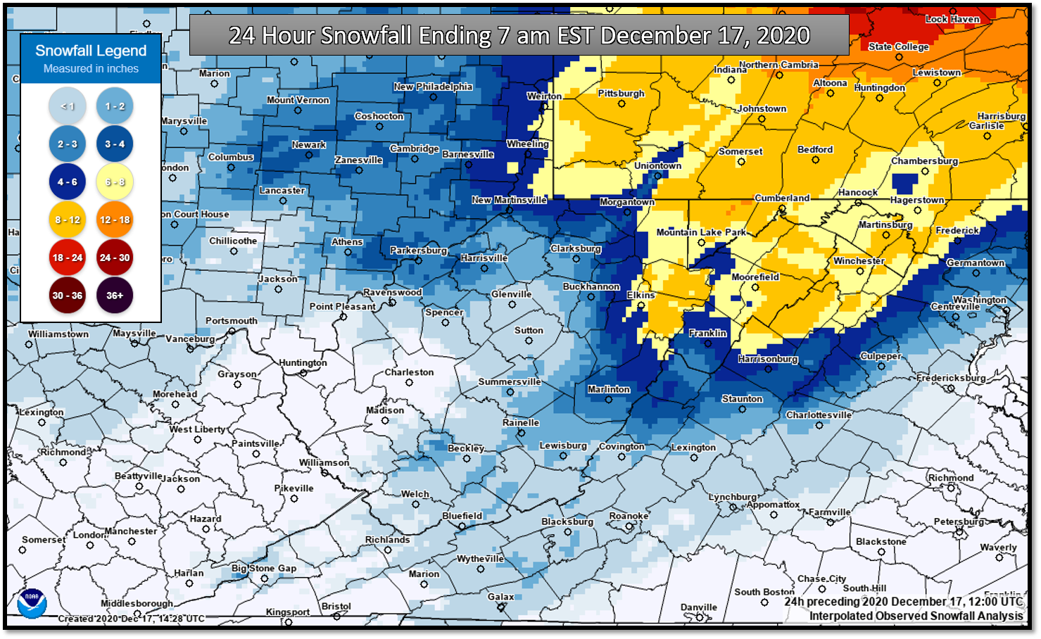
...STORM TOTAL FREEZING RAIN, SLEET AND SNOW REPORTS...

A developing winter storm brought a wintry mix of precipitation to the
Mid-Ohio Valley and Central Appalachians yesterday and overnight. The
following winter weather reports were collected from a variety of
sources with varying equipment and exposures. We thank all volunteer
weather observers and our partners for their reports!


...STORM TOTAL FREEZING RAIN REPORTS...

Location                     Amount    Time/Date       Provider

...West Virginia...

...Fayette County...
5 NNW Meadow Bridge          0.10 in   0100 PM 12/16   Post Office

...Nicholas County...
7 SSW Craigsville            0.10 in   1248 PM 12/16   Dept of Highways

...Raleigh County...
Beckley Airport              0.28 in   0351 PM 12/16   ASOS

...Randolph County...
Valley Head                  0.25 in   1222 PM 12/16   Dept of Highways
2 SSW Elkins                 0.16 in   0113 PM 12/16   ASOS

...Webster County...
Cowen                        0.10 in   1241 PM 12/16   Dept of Highways


...STORM TOTAL SLEET REPORTS...

Location                     Amount    Time/Date       Provider

...West Virginia...

...Raleigh County...
Daniels                      1.0 in    1232 PM 12/16   Public

...Randolph County...
4 NNE Harman                 0.5 in    1218 PM 12/16   Post Office


...STORM TOTAL SNOWFALL REPORTS...

Location                     Amount    Time/Date       Provider

...Ohio...

...Athens County...
Stewart 4.6 NNE              3.6 in    0700 AM 12/17   COCORAHS
Athens 2.3 SSE               3.0 in    0700 AM 12/17   COCORAHS
Athens 1.3 N                 2.8 in    0700 AM 12/17   COCORAHS
Amesville 2.6 SE             2.4 in    0830 AM 12/17   COCORAHS
Athens 7.0 WNW               2.0 in    0700 AM 12/17   COCORAHS
Athens 4.6 ESE               1.8 in    0800 AM 12/17   COCORAHS
Glouster 3.6 SW              1.5 in    0700 AM 12/17   COCORAHS
Coolville                    1.5 in    0334 PM 12/16   Public

...Jackson County...
Jackson 3 NW                 0.6 in    0651 AM 12/17   COOP

...Meigs County...
6 NE Pomeroy                 2.7 in    0655 PM 12/16   Public

...Morgan County...
Stockport                    1.5 in    0336 PM 12/16   Public

...Perry County...
New Lexington 2 NW           2.8 in    0700 AM 12/17   COOP

...Washington County...
9 N Coolville                4.6 in    0919 PM 12/16   Public
5 NW Belpre                  4.0 in    0926 PM 12/16   Public
Lowell                       2.0 in    0333 PM 12/16   Public
Newport                      1.5 in    0810 AM 12/17   COOP
1 W Marietta                 1.5 in    0341 PM 12/16   Public

...Virginia...

...Dickenson County...
Nora 4 SSE                   0.1 in    0700 AM 12/17   COOP

...West Virginia...

...Barbour County...
Belington                    6.0 in    0240 AM 12/17   PUBLIC
Philippi                     4.0 in    0700 AM 12/17   PUBLIC

...Doddridge County...
Center Point 2.2 NNW         1.8 in    0700 AM 12/17   COCORAHS
West Union 2.9 SE            1.2 in    0730 AM 12/17   COCORAHS
West Union 5.9 NE            1.0 in    0700 AM 12/17   COCORAHS

...Fayette County...
6 ESE Ansted                 2.0 in    0700 AM 12/17   PUBLIC

...Harrison County...
Clarksburg                   2.0 in    0600 AM 12/17   COOP
1 NW Lost Creek              0.8 in    0911 PM 12/16   Public

...Lewis County...
Stonewall Jackson            0.6 in    0710 AM 12/17   COOP

...Nicholas County...
Craigsville 0.6 NE           1.5 in    0700 AM 12/17   COCORAHS
Mount Nebo                   1.0 in    0700 AM 12/17   COOP

...Pocahontas County...
4 WSW Snowshoe               6.0 in    0256 PM 12/16   Dept of Highways
Bartow 1 S                   5.6 in    0730 AM 12/17   COOP
Snowshoe                     5.0 in    0600 AM 12/17   COOP
Frost 3 NE                   4.5 in    0630 AM 12/17   COOP
Cass 3.7 SW                  3.0 in    0700 AM 12/17   COCORAHS
2 ESE Durbin                 2.3 in    1200 PM 12/16   CO-OP Observer
1 N Marlinton                2.0 in    1235 PM 12/16   Dept of Highways

...Raleigh County...
Beckley                      1.0 in    0700 AM 12/17   COOP
Beckley Airport              0.5 in    0700 AM 12/17   COOP

...Randolph County...
2 W Harman                   6.0 in    0258 PM 12/16   Dept of Highways

...Ritchie County...
Pennsboro 1.2 ESE            3.0 in    0700 AM 12/17   COCORAHS

...Taylor County...
Tygart Lake                  3.8 in    0700 AM 12/17   COOP

...Tyler County...
2 ESE Sistersville           2.0 in    0107 PM 12/16   Dept of Highways

...Upshur County...
Rock Cave 2 NE               3.2 in    0825 AM 12/17   COOP
Buckhannon                   3.0 in    0700 AM 12/17   COOP

...Webster County...
1 N Webster Springs          3.5 in    0700 AM 12/17   PUBLIC
Hacker Valley                0.5 in    0710 AM 12/17   COOP

...Wood County...
Williamstown 0.4 WNW         3.0 in    0700 AM 12/17   COCORAHS
Williamstown                 2.8 in    0853 PM 12/16   Public
Vienna 1.3 NE                2.5 in    0700 AM 12/17   COCORAHS
Walker 2.1 SW                2.5 in    0645 AM 12/17   COCORAHS
6 E Mineralwells             2.2 in    1040 PM 12/16   Public
5 E Mineralwells             1.8 in    0805 PM 12/16   Cocorahs
4 ESE Parkersburg            1.3 in    0706 PM 12/16   Trained Spotter