National Weather Service United States Department of Commerce
 

Back to back ice storms affected our region February 10th and 11th and then again February 15th and 16th, leading to widespread tree damage and extensive power outages across the Tri-State region of Kentucky, Ohio and West Virginia.  Another winter storm impacted the region with snow and freezing rain on February 17th through the 18th, hindering the efforts to restore power across the Tri-State region and causing hazardous travel conditions across much of the region.

Maps of interpolated observed snowfall (courtesy of the National Operational Hydrologic Remote Sensing Center) along with freezing rain reports for each of these three storms is included below.  Many of the reports used to create these maps were provided by volunteer weather spotters, Cooperative Weather Observers and CoCoRaHS observers and we thank them for their diligence and reports!


Snowfall analysis and freezing rain reports for the 48 hour period ending 7 am EST February 12, 2021


Snowfall analysis and freezing rain reports for the 48 hour period ending 7 am EST February 16, 2021


Snowfall analysis and freezing rain reports for the 48 hour period ending 7 am EST February 19, 2021


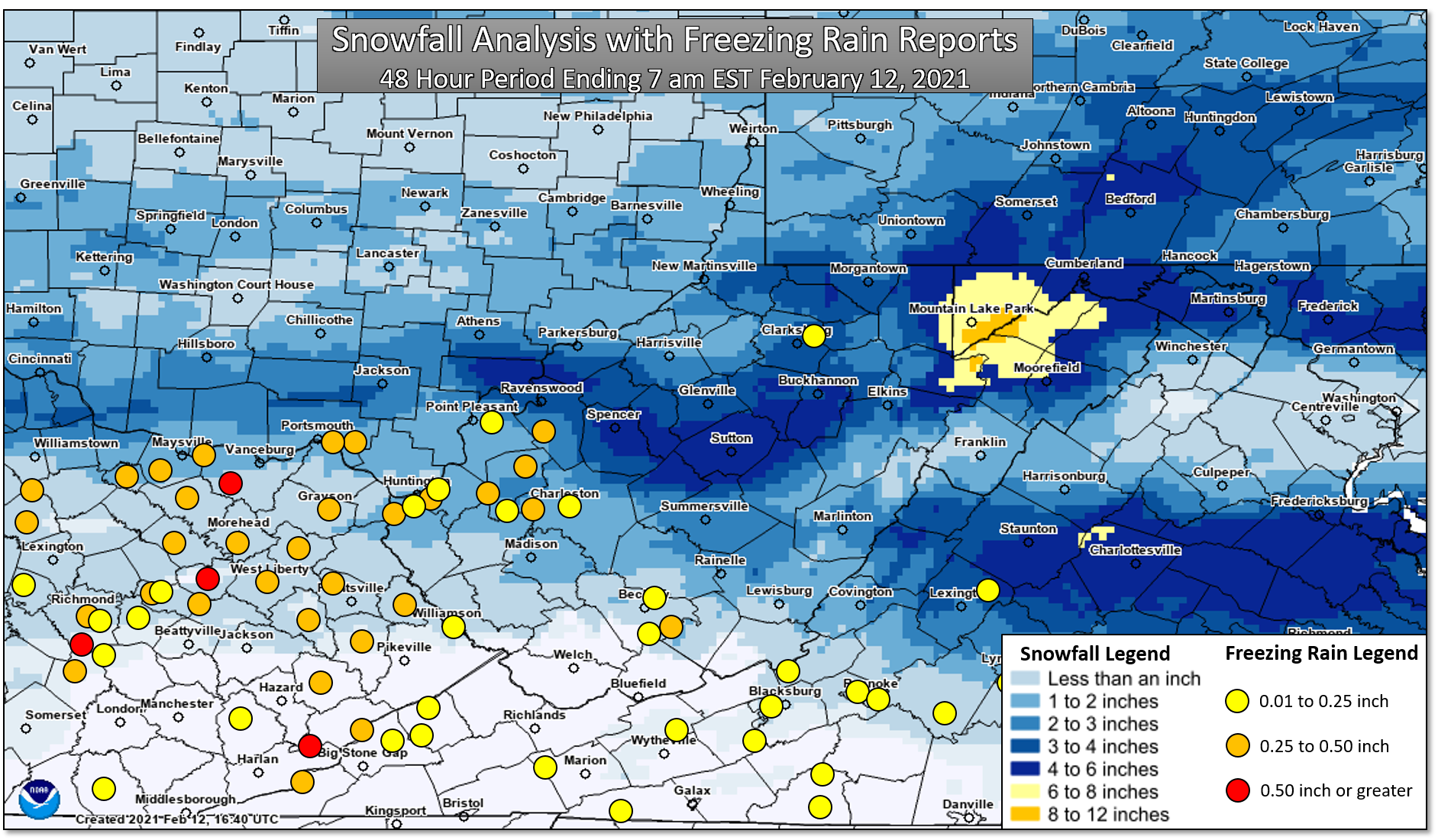
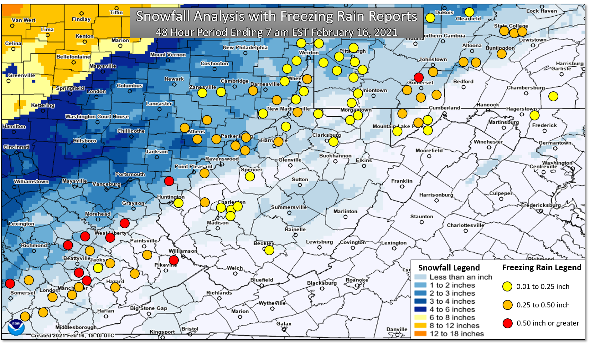
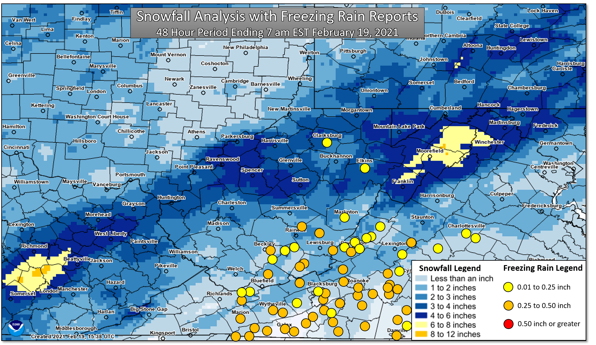
The hardest hit counties were Boyd, Carter and Lawrence in Kentucky, Lawrence County, Ohio, and Wayne, Cabell, Putnam and Lincoln Counties in West Virginia.  Here's a breakdown of impacts by state:

  • Kentucky
    • According to Kentucky Power, extensive damage to circuits occurred in Boyd, Carter and Lawrence Counties.  The "unprecedented" magnitude of the damage required total reconstruction of destroyed circuits.
    • According to poweroutage.us, at one point on February 16, 40,000 customers, or 65% of total customers served in Boyd, Carter, Lawrence and Greenup Counties in Kentucky were without power.  Percentages of customers out of power per county at height of storm:
      • ​Lawrence 99%
      • Carter 88%
      • Boyd 66%
      • Greenup 15%
    • ​Two deaths in Boyd County were attributed to hypothermia due to loss of power.
  • West Virginia
    • According to Appalachian Power, the weight of the snow and ice caused trees to collapse onto wires and transmission towers to buckle.  An estimated 550 broken power poles needed to be replaced and roughly 2,400 spans of wire needed to be put back up.
    • According to poweroutage.us, at one point on February 16, 100,000 customers were without power in West Virginia, or roughly 10% of the state's customers.  Hardest hit areas were as follows with percentages of customers out of power at the height of the storm indicated:
      • ​Wayne 79%
      • Lincoln 70%
      • Cabell 63%
      • Putnam 60%
      • Jackson 33%
      • Mason 30%
  • ​​Ohio
    • ​Lawrence and Gallia Counties were hard hit by the repeating winter storms.  At the peak of the storm, 51% of Lawrence County and 16% of Gallia County was without power, according to poweroutage.us.

Many photos of the ice and resulting damage from the ice storms that targeted the Tri-State region were captured in the comments to the following Facebook post.

📰 We are looking for 📸 from the recent ice storm to archive for our event review. Feel free to send us your pictures of...

Posted by US National Weather Service Charleston WV on Tuesday, February 16, 2021