Thunderstorms dropped torrential rainfall in many areas Wednesday afternoon and into the evening hours. Multiple stations reported over 2 inches of rainfall over 24 hours with some stations recording up to 5 inches of rain.
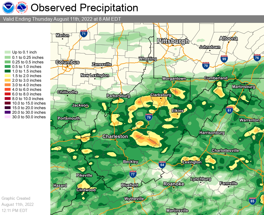
The following is a county based summary of 24 hour accumulated rainfall ending at the indicated time from a combination of Cooperative Weather Observers, CoCoRaHS Rainfall Observers, as well as public and government-owned automated weather stations.
| Location | Amount | Time/Date | Provider |
| ...Kentucky... | |||
| ...Boyd County... | |||
| Ashland | 2.72 in | 1110 AM 08/11 | CWOP |
| ...Carter County... | |||
| 4.7 E Carter Caves State Park | 1.55 in | 0800 AM 08/11 | IFLOWS |
| ...Lawrence County... | |||
| Louisa 5 W | 1.93 in | 0730 AM 08/11 | COOP |
| ...Ohio... | |||
| South Point | 2.00 in | 0700 AM 08/11 | COOP |
| ...Virginia... | |||
| ...Buchanan County... | |||
| Grundy | 1.66 in | 0700 AM 08/11 | COOP |
| ...West Virginia... | |||
| ...Barbour County... | |||
| Belington | 1.72 in | 1105 AM 08/11 | CWOP |
| 3 SE Philippi | 1.60 in | 1120 AM 08/11 | AWS |
| ...Cabell County... | |||
| Huntington 1.7 ESE | 2.59 in | 0800 AM 08/11 | COCORAHS |
| Huntington 2.9 E | 2.20 in | 0610 AM 08/11 | COCORAHS |
| Huntington | 1.90 in | 1100 AM 08/11 | CWOP |
| 1 ESE Huntington | 1.90 in | 1120 AM 08/11 | AWS |
| ...Calhoun County... | |||
| 3.9 W Arnoldsburg | 3.48 in | 0500 AM 08/11 | IFLOWS |
| 4.4 SW Grantsville | 1.56 in | 0500 AM 08/11 | IFLOWS |
| ...Clay County... | |||
| Clay 0.2 WSW | 1.50 in | 0700 AM 08/11 | COCORAHS |
| ...Doddridge County... | |||
| 4.0 S West Union | 5.72 in | 0400 AM 08/11 | IFLOWS |
| 4.6 W Salem | 4.06 in | 1200 AM 08/11 | IFLOWS |
| West Union 2.9 SE | 2.98 in | 0730 AM 08/11 | COCORAHS |
| West Union 5.6 ESE | 2.70 in | 0645 AM 08/11 | COCORAHS |
| Auburn 8.3 ENE | 1.72 in | 0800 AM 08/11 | COCORAHS |
| ...Fayette County... | |||
| 0.6 S Thurmond | 1.53 in | 0945 AM 08/11 | HADS |
| ...Harrison County... | |||
| 1.6 E Bridgeport | 3.36 in | 1100 PM 08/10 | IFLOWS |
| Lost Creek 1.3 NW | 3.15 in | 0700 AM 08/11 | COCORAHS |
| Clarksburg Airport | 2.64 in | 1053 AM 08/11 | ASOS |
| 1 NE Anmoore | 2.00 in | 0845 PM 08/10 | |
| ...Jackson County... | |||
| Ripley 5.8 S | 2.39 in | 0700 AM 08/11 | COCORAHS |
| 5 NNW Kenna | 2.37 in | 0740 PM 08/10 | Cocorahs |
| ...Kanawha County... | |||
| Sissonville 1 SW | 1.55 in | 0700 AM 08/11 | COOP |
| ...Lewis County... | |||
| 4.4 SW Stonewall Jackson | 3.70 in | 0500 AM 08/11 | IFLOWS |
| 5.1 W Weston | 1.95 in | 0700 AM 08/11 | IFLOWS |
| Stonewall Jackson | 1.57 in | 1115 PM 08/10 | COOP |
| ...Mason County... | |||
| 5.8 E Leon | 1.52 in | 1100 PM 08/10 | IFLOWS |
| ...Nicholas County... | |||
| 4.1 NW Richwood | 4.33 in | 0800 AM 08/11 | IFLOWS |
| Craigsville | 3.31 in | 1100 AM 08/11 | CWOP |
| Craigsville 0.6 NE | 2.94 in | 0700 AM 08/11 | COCORAHS |
| 5.1 N Richwood | 2.51 in | 0930 AM 08/11 | HADS |
| 2.1 S Craigsville | 1.60 in | 0930 AM 08/11 | HADS |
| ...Randolph County... | |||
| Elkins Airport | 2.18 in | 1051 AM 08/11 | ASOS |
| 3.0 W Womelsdorf (coalton) | 1.79 in | 1100 PM 08/10 | IFLOWS |
| 6.1 SE Huttonsville | 1.54 in | 0930 AM 08/11 | HADS |
| ...Ritchie County... | |||
| 8.5 S Cairo | 4.13 in | 1100 AM 08/11 | IFLOWS |
| Pennsboro 1.2 ESE | 1.70 in | 0700 AM 08/11 | COCORAHS |
| ...Taylor County... | |||
| 4.3 W Newburg | 2.70 in | 0300 AM 08/11 | IFLOWS |
| Grafton | 1.92 in | 1100 AM 08/11 | CWOP |
| ...Wayne County... | |||
| East Lynn Lake | 2.36 in | 0700 AM 08/11 | COOP |
| Huntington Airport | 1.91 in | 1051 AM 08/11 | ASOS |
| ...Webster County... | |||
| 7.4 SE Cowen | 1.94 in | 1045 AM 08/11 | HADS |
| ...Wirt County... | |||
| 3.4 NW Reedy | 2.39 in | 0100 AM 08/11 | IFLOWS |
| 9.1 W Grantsville | 2.07 in | 1100 AM 08/11 | IFLOWS |
| ...Wood County... | |||
| Davisville 3.8 NE | 3.02 in | 0700 AM 08/11 | COCORAHS |
| 4.6 S Washington | 2.26 in | 0900 AM 08/11 | IFLOWS |
| Parkersburg | 1.90 in | 1100 AM 08/11 | CWOP |

