Event Synopsis
|
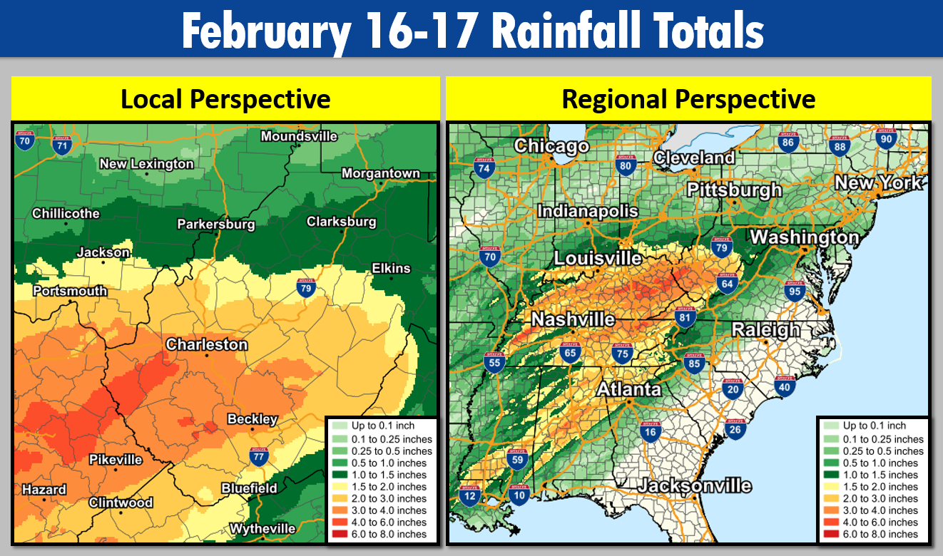
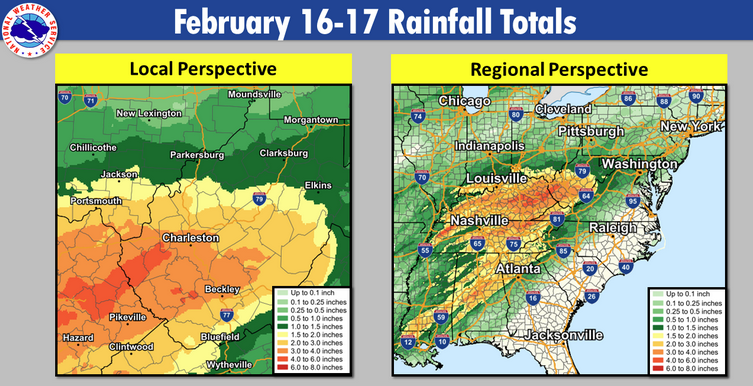
Multiple rounds of moderate to heavy rain affected portions of the region on February 16-17, 2023. This occurred ahead of a deepening area of low pressure that would pass just northwest of the region during the afternoon/evening hours of Thursday, February 16th. When all was said and done, rainfall totals of 2-4" fell across much of the central/southern portion of the NWS Charleston forecast area, leading to numerous flooding issues across the region, both in terms of areal and river flooding. Rainfall totals were high enough for both Beckley, WV and Huntington, WV to set daily rainfall records on February 16th. Fortunately, mainly dry weather would follow this system for the next few days, allowing for any lingering river flooding to recede by the early morning hours of Saturday, February 18th. Please click on the tabs below for more detailed information about this event. Please note that most images/loops can be expanded by clicking on them. |
.gif)
February 16-17th Regional Radar Loop Radar loop courtesy of Iowa Environmental Mesonet (IEM) |
 |
 |
 |
|
Event Total Rainfall Amounts Rainfall Totals of 2-4" (Central/South) |
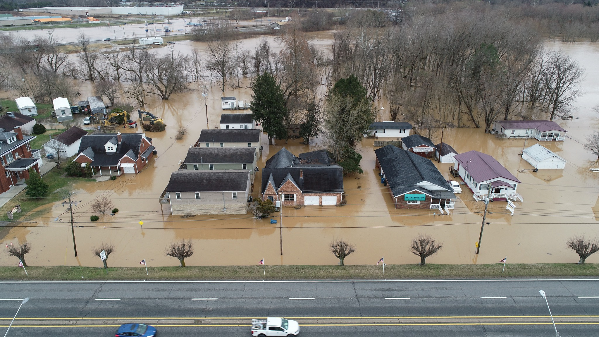
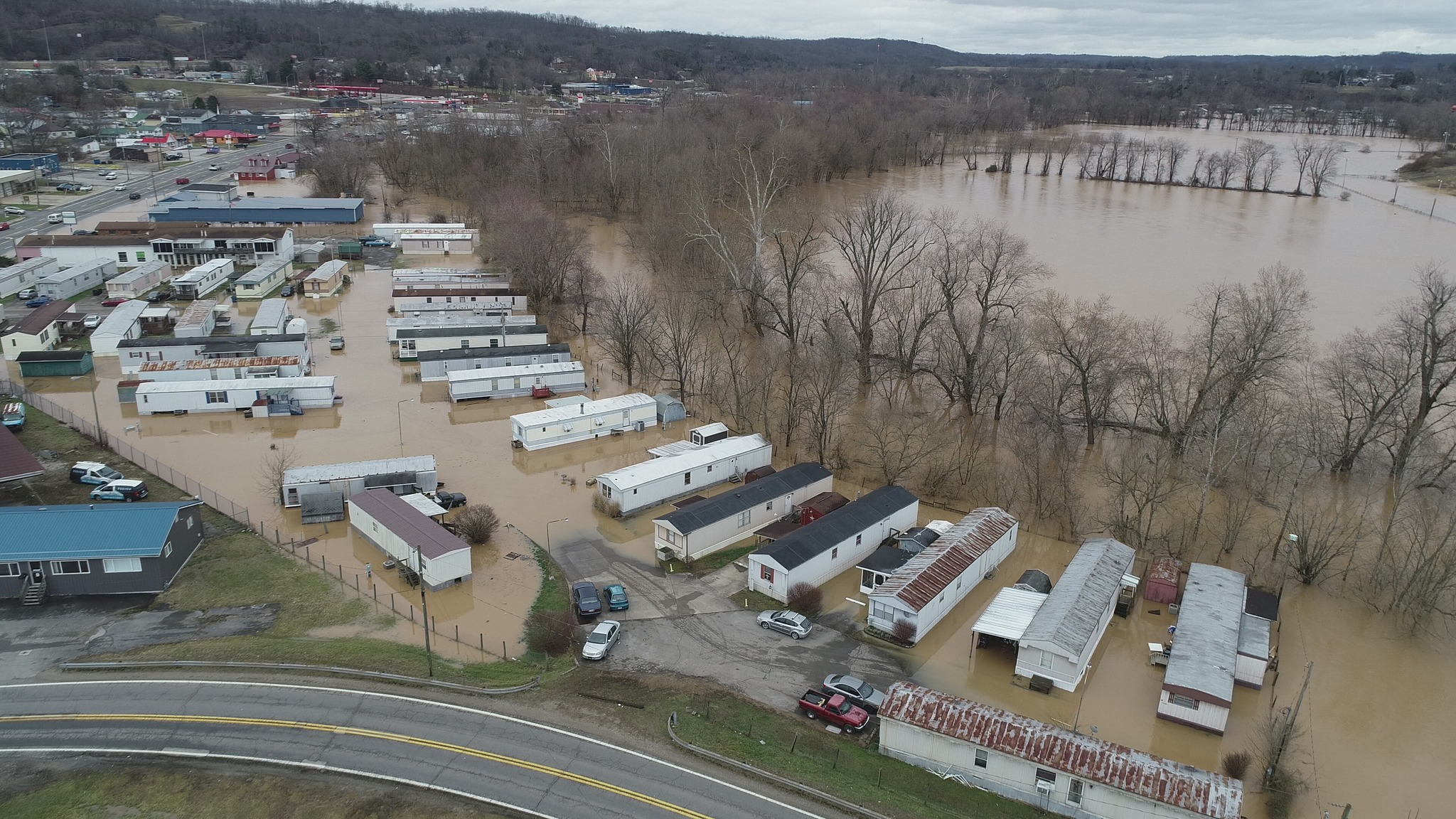
Mud River Flooding in Milton, WV (Photo Credit: City of Milton) |
Mud River Flooding in Milton, WV (Photo Credit: City of Milton) |
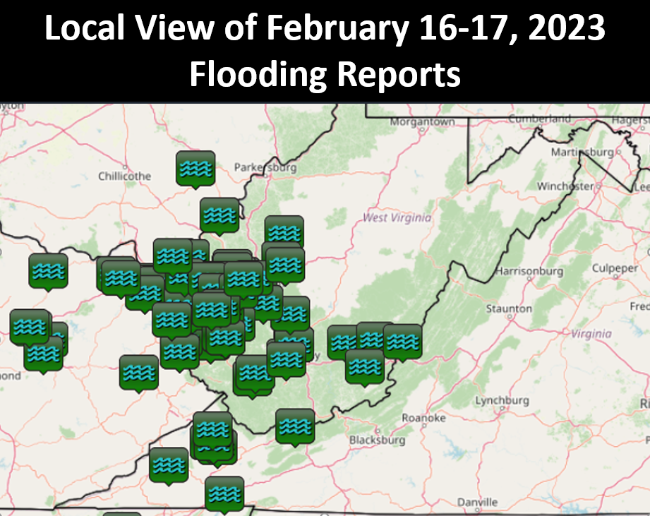
Overview
Both areal and river flooding were observed with this event. Numerous road closures were reported, with several river gauges going above flood stage. Additionally, a water rescue was reported, as well as a couple of mudslides, one of which resulted in a train derailment in Ragland, WV (Mingo County). One fatality did occur with this event in Pax, WV (Fayette County) when someone drowned due to being swept away on a flooded roadway.
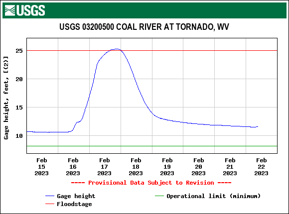
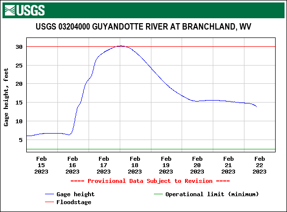
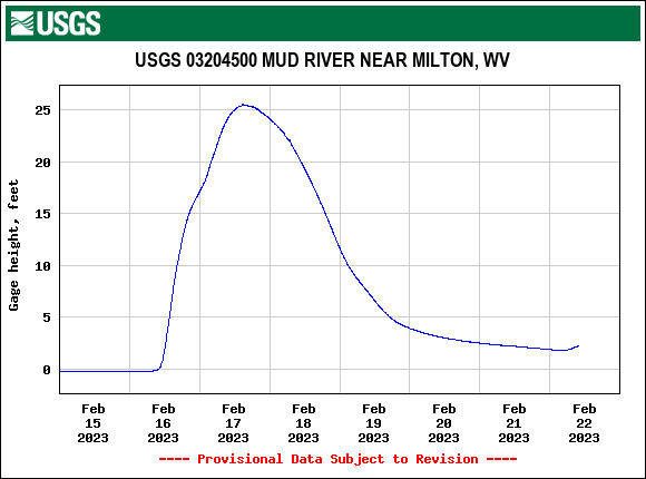
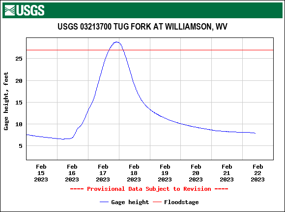
Several hydrographs can be seen below illustrating the river flooding across the region. Those not pictured below that also reached flood stage include the: Elk River, Big Coal River, Knapp Creek, Symmes Creek, Cranes Nest River, and Pound River. A radar loop with flood warnings overlaid, throughout the entirety of the event, can be seen under the 'Radar Loops' tab.
 |
 |
 |
 |
|
Hydrograph Courtesy of USGS **Minor Flood Stage Reached** |
Hydrograph Courtesy of USGS **Minor Flood Stage Reached** |
Hydrograph Courtesy of USGS **Moderate Flood Stage Reached** |
Hydrograph Courtesy of USGS **Minor Flood Stage Reached** |
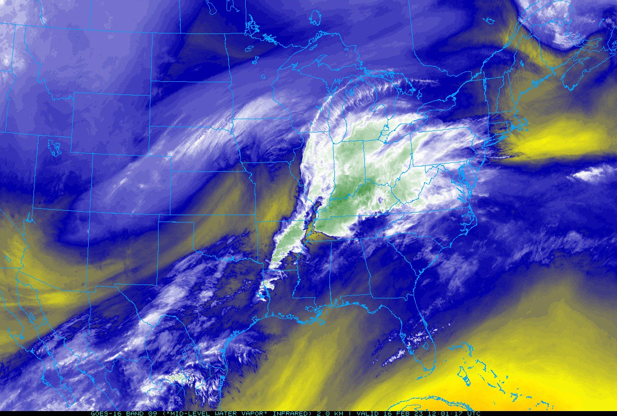
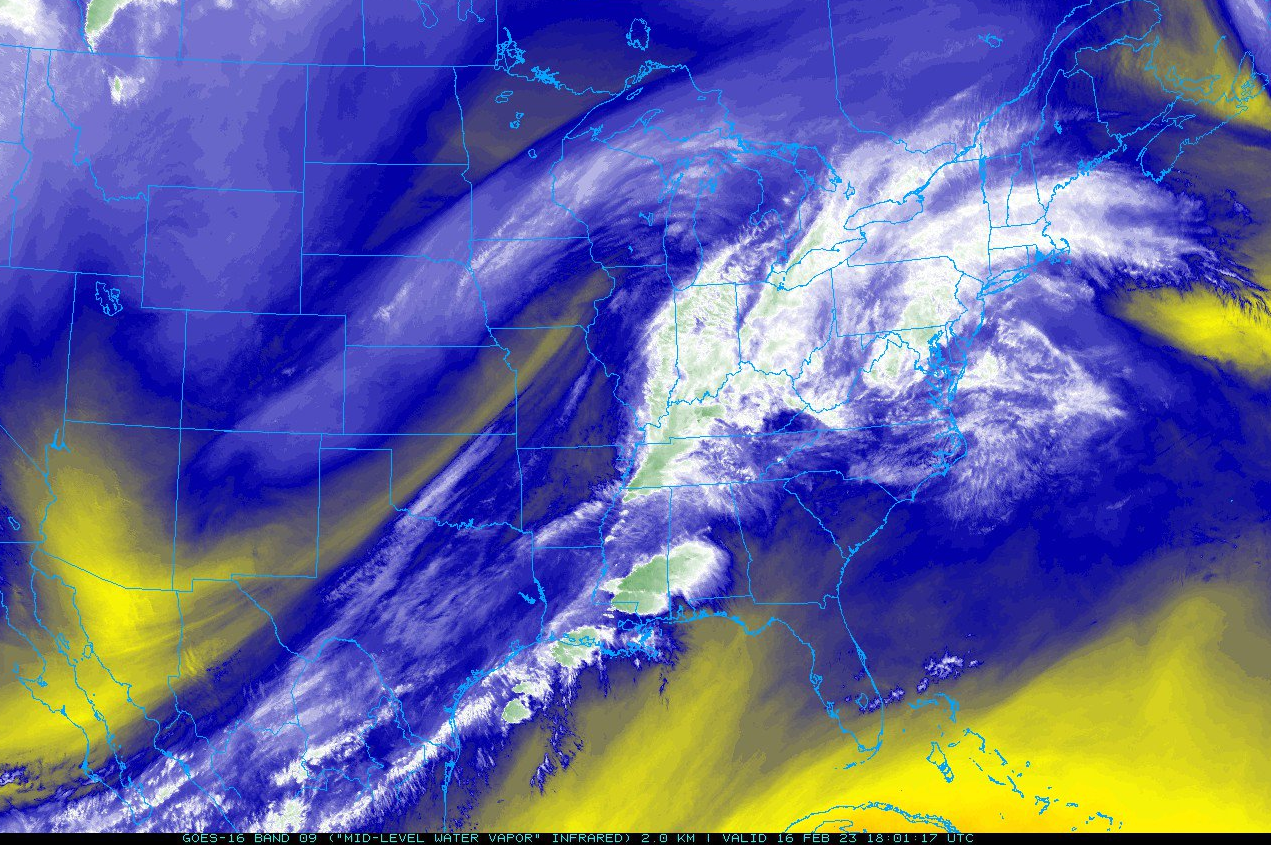
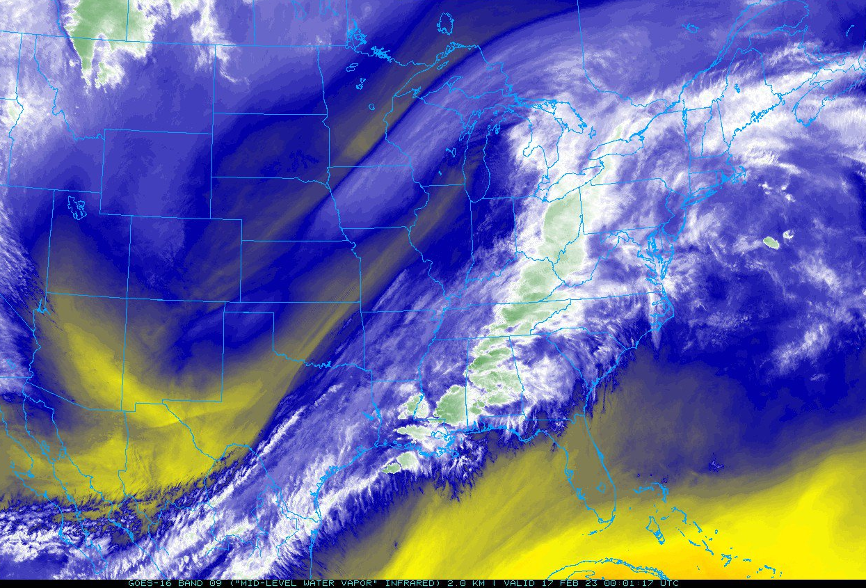
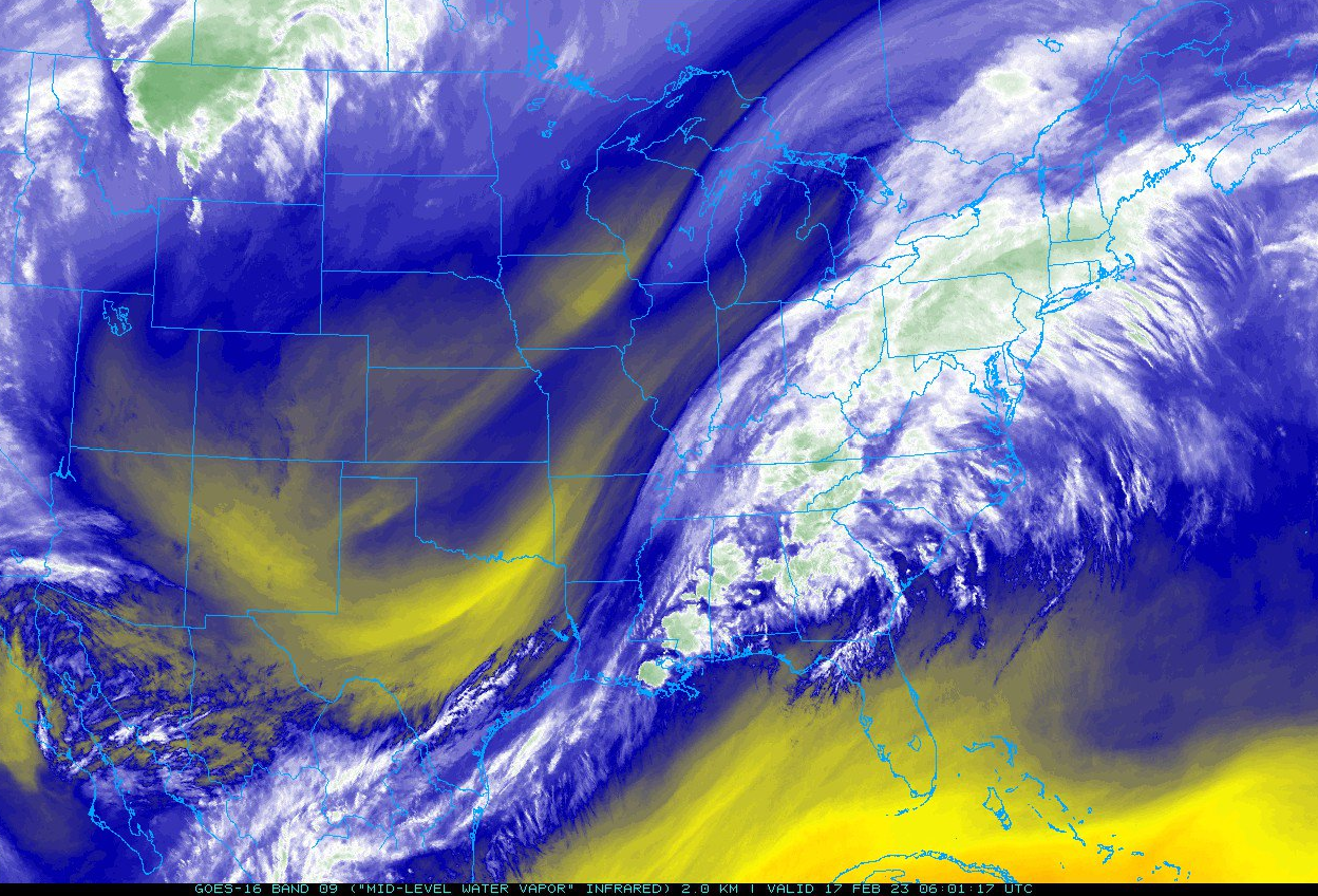
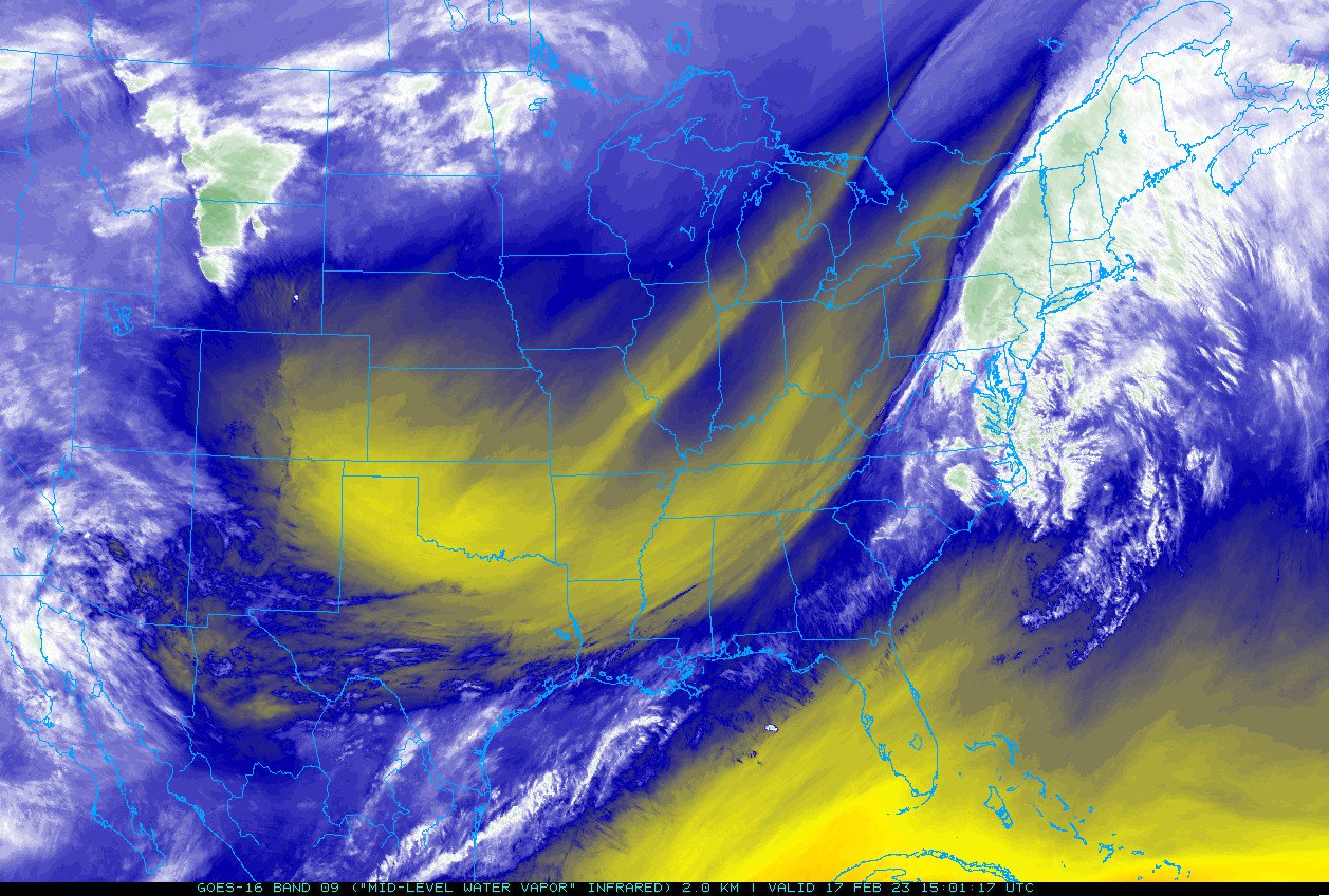
Subtropical Moisture Stream
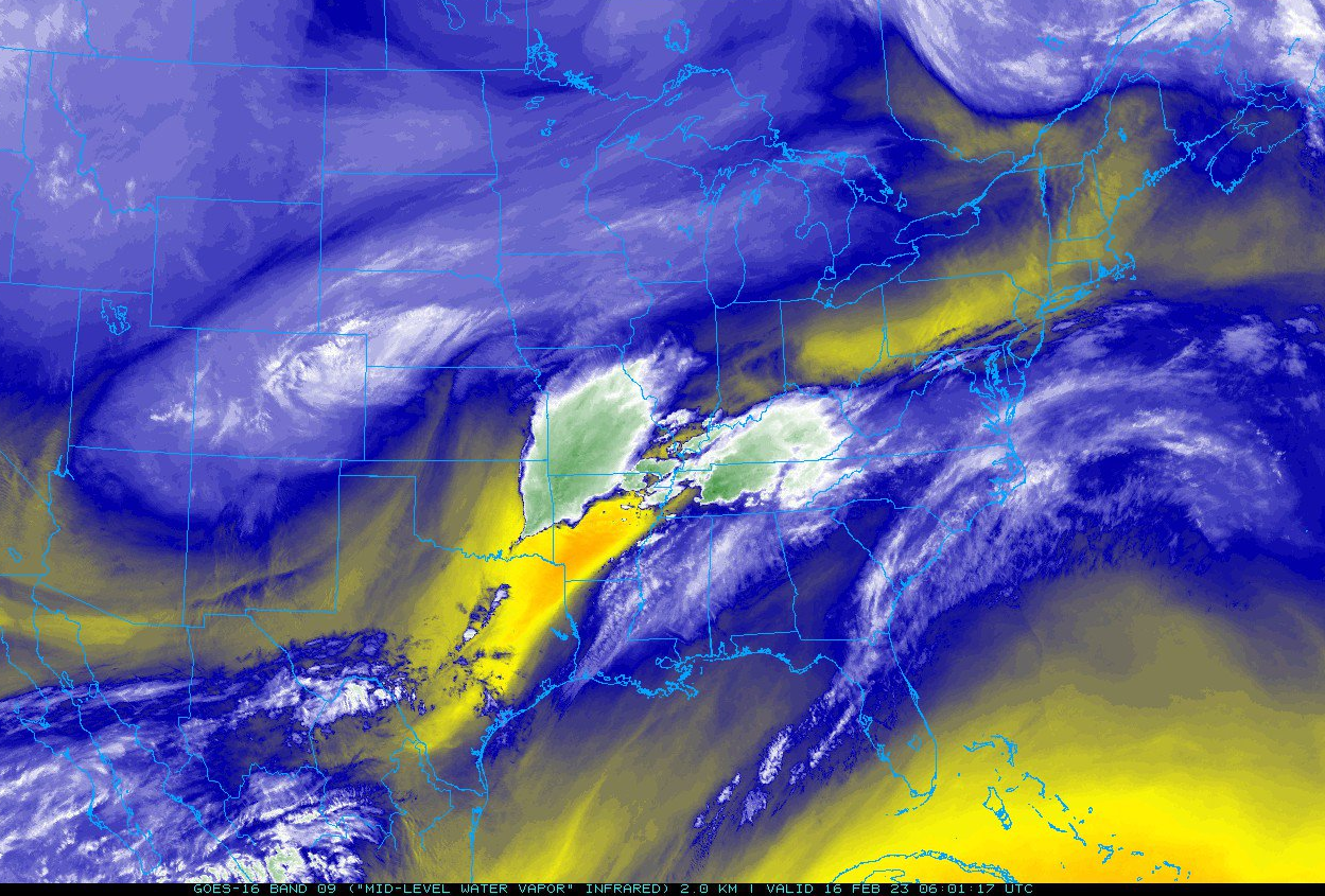
Abundant moisture was transported into the region during this event courtesy of the subtropical jet. This can be seen (below) by looking at the GOES-16 6.9 µm 'Mid-level water vapor' band. The yellow colors indicate a relative lack of mid/upper level water vapor, while the white, and particularly green colors represent an abundance of mid/upper level moisture.
 |
 |
 |
|
1 AM February 16th: Mid-level Water Vapor Image (GOES-16) Satellite image courtesy of NEXLAB - College of Dupage |
7 AM February 16th: Mid-level Water Vapor Image (GOES-16) Satellite image courtesy of NEXLAB - College of Dupage |
1 PM February 16th: Mid-level Water Vapor Image (GOES-16) Satellite image courtesy of NEXLAB - College of Dupage |
 |
 |
 |
|
7 PM February 16th: Mid-level Water Vapor Image (GOES-16) Satellite image courtesy of NEXLAB - College of Dupage |
1 AM February 17th: Mid-level Water Vapor Image (GOES-16) Satellite image courtesy of NEXLAB - College of Dupage |
10 AM February 17th: Mid-level Water Vapor Image (GOES-16) Satellite image courtesy of NEXLAB - College of Dupage |
February 16-17 Local/Regional Radar Loops Covering the Entirety of the Event
(1).gif) |
.gif) |
|
|
February 16-17 Local Radar Loop Radar loop courtesy of Iowa Environmental Mesonet (IEM) |
February 16-17 Local Radar Loop (w/ Flood Warnings Overlaid) Radar loop courtesy of Iowa Environmental Mesonet (IEM) |
February 16-17 Regional Radar Loop Radar loop courtesy of Iowa Environmental Mesonet (IEM) |
................FEBRUARY 16-17, 2023 FLOODING REPORTS................
..TIME... ...EVENT... ...CITY LOCATION... ...LAT.LON...
..DATE... ....MAG.... ..COUNTY LOCATION..ST.. ...SOURCE....
..REMARKS..
0222 PM FLOOD WAYNE 38.22N 82.44W
02/17/2023 WAYNE WV TRAINED SPOTTER
TWELVEPOLE CREEK HAS BEEN RISING STEADILY
SINCE THE MORNING AND NOW BRIDGE STREET IS
FLOODED AND IMPASSABLE.
0100 PM FLOOD 2 E TORNADO 38.34N 81.82W
02/17/2023 KANAWHA WV FIRE DEPT/RESCUE
WATER RESCUE ON SMITH CREEK RD. PERSON IS ON
THE TOP OF THEIR VEHICLE.
1100 AM FLOOD 2 SSE WEST HAMLIN 38.26N 82.18W
02/17/2023 LINCOLN WV PUBLIC
ONE MILE CREEK OUT OF ITS BANKS AND FLOODING
DR. STEELE FARM RD AND ONE MILE RD.
1030 AM DEBRIS FLOW RAGLAND 37.70N 82.12W
02/17/2023 MINGO WV BROADCAST MEDIA
COAL TRAIN DERAILMENT DUE TO A MUDSLIDE. A
HOME WAS ALSO REMOVED FROM ITS FOUNDATION.
1030 AM FLOOD PAX 37.91N 81.27W
02/17/2023 FAYETTE WV BROADCAST MEDIA
PAINT CREEK OUT OF ITS BANKS AND FLOODING
PAINT CREEK RD. NEAR INTERSECTION WITH
MILLSTONE CIR.
1030 AM FLOOD 2 NNE DAVENPORT 37.13N 82.12W
02/17/2023 BUCHANAN VA LAW ENFORCEMENT
RTE 657 NEAR THE INTERSECTION OF FOXFIRE RD.
IS CLOSED DUE TO FLOODING.
1030 AM FLOOD 3 ENE DAVENPORT 37.12N 82.08W
02/17/2023 BUCHANAN VA LAW ENFORCEMENT
RTE. 600 NEAR THE PEALOG BRANCH INTERSECTION
IS CLOSED DUE TO FLOODING.
1000 AM FLOOD LYNCO 37.69N 81.65W
02/17/2023 WYOMING WV BROADCAST MEDIA
SEVERAL ROADS IN THE COMMUNITY REPORTED NOT
PASSABLE DUE TO FLOODING.
1000 AM FLOOD CLEAR FORK 37.64N 81.68W
02/17/2023 WYOMING WV BROADCAST MEDIA
RTE. 971 NEAR WESTSIDE HIGHSCHOOL IS CLOSED
DUE TO FLOODING.
1000 AM FLOOD STOVER 37.82N 81.34W
02/17/2023 RALEIGH WV BROADCAST MEDIA
MATTVILLE RD. CLOSED DUE TO FLOODING.
1000 AM FLOOD 1 N GLEN DANIEL 37.79N 81.34W
02/17/2023 RALEIGH WV BROADCAST MEDIA
COAL RIVER RD. IN GLEN DANIEL CLOSED DUE TO
FLOODING.
1000 AM FLOOD SMITHERS 38.16N 81.30W
02/17/2023 FAYETTE WV BROADCAST MEDIA
RTE. 60 IS CLOSED BETWEEN SMITHERS AND
BOOMER DUE TO FLOODING.
0930 AM FLOOD 5 E DAVENPORT 37.09N 82.04W
02/17/2023 BUCHANAN VA LAW ENFORCEMENT
RTE 622 IN THE GRISSOM CREEK AREA IS CLOSED
DUE TO FLOODING.
0913 AM FLOOD VANSANT 37.23N 82.09W
02/17/2023 BUCHANAN VA PUBLIC
ROUTE 605 IN VANSANT IS COVERED BY AT LEAST
2 FEET OF WATER DUE TO FLOODING OF THE
RUSSEL FORK.
0900 AM FLOOD 5 NE HAMLIN 38.34N 82.04W
02/17/2023 LINCOLN WV PUBLIC
TRACE FORK OUT OF ITS BANKS AT THE PUTNAM
COUNTY LINE AND FLOODING A SECTION OF RTE.
34.
0843 AM FLOOD SPENCER 38.80N 81.36W
02/17/2023 ROANE WV PUBLIC
SOCIAL MEDIA IMAGES SHOWING FLOODING ALONG
FRONT STREET IN SPENCER.
0826 AM FLOOD PAX 37.91N 81.26W
02/17/2023 FAYETTE WV BROADCAST MEDIA
*** 1 FATAL ***
VEHICLE DROVE ONTO A FLOODED ROAD AND WAS
SWEPT AWAY ALONG WITH AN INFANT. LOCAL
AUTHORITIES LATER FOUND THE INFANT HAD
DROWNED.
0653 AM FLOOD 1 W DANVILLE 38.08N 81.85W
02/17/2023 BOONE WV 911 CALL CENTER
WATER ABOUT TO GO OVER LICK CREEK ROAD.
0511 AM FLOOD SAINT ALBANS 38.38N 81.82W
02/17/2023 KANAWHA WV 911 CALL CENTER
WATER OVER BROWNS CREEK ROAD.
0511 AM FLOOD TORNADO 38.33N 81.86W
02/17/2023 KANAWHA WV 911 CALL CENTER
WATER OVER FERRELL ROAD AND SMITH CREEK
ROAD.
0511 AM FLOOD CHARLESTON 38.35N 81.63W
02/17/2023 KANAWHA WV 911 CALL CENTER
WATER OVER GREENBRIER STREET.
0317 AM FLOOD HURRICANE 38.44N 82.02W
02/17/2023 PUTNAM WV 911 CALL CENTER
WATER ACROSS TEAYS VALLEY ROAD AT HURRICANE
CITY PARK.
0300 AM FLOOD MILTON 38.43N 82.14W
02/17/2023 CABELL WV OFFICIAL NWS OBS
MUD RIVER IN FLOOD.
1100 PM FLOOD 3 E CHAPMANVILLE 37.97N 81.96W
02/16/2023 LOGAN WV 911 CALL CENTER
FLOODING REPORTED ALONG GARRETS FORK.
1100 PM FLOOD 6 WSW CHAPMANVILLE 37.93N 82.11W
02/16/2023 LOGAN WV 911 CALL CENTER
FLOODING REPORTED ALONG BROWNS RUN ROAD.
1100 PM FLOOD 1 NE CHAPMANVILLE 37.99N 82.00W
02/16/2023 LOGAN WV 911 CALL CENTER
FLOODING REPORTED ALONG PERRY BRANCH ROAD.
1005 PM FLOOD PAX 37.91N 81.26W
02/16/2023 FAYETTE WV 911 CALL CENTER
FLOODING REPORTED ALONG PACKS BRANCH ROAD.
1005 PM FLOOD PAX 37.91N 81.26W
02/16/2023 FAYETTE WV 911 CALL CENTER
FLOODING REPORTED ALONG PAINT CREEK ROAD AT
MILE 6.5 TO MILE 8.7.
0824 PM FLOOD 8 NNE CARTER CAVES STAT 38.48N 83.07W
02/16/2023 GREENUP KY DEPT OF HIGHWAYS
THREE PRONG ROAD NEAR BUBBLE RIDGE WOLFE
ROAD BLOCKED DUE TO FLOODING.
0819 PM FLOOD 2 NNW KERMIT 37.86N 82.42W
02/16/2023 WAYNE WV PUBLIC
STREET FLOODING.
0808 PM FLOOD 7 NE CARTER CAVES STATE 38.45N 83.02W
02/16/2023 GREENUP KY DEPT OF HIGHWAYS
BIG LOST CREEK ROAD NEAR SHAWS BRIDGE ROAD
BLOCKED DUE TO FLOODING.
0805 PM FLOOD 2 SE HURRICANE 38.41N 81.99W
02/16/2023 PUTNAM WV 911 CALL CENTER
BOTH SIDES OF STEWART RD BLOCKED BY WATER.
0730 PM DEBRIS FLOW CLAY 38.46N 81.08W
02/16/2023 CLAY WV PUBLIC
HUGE SLIP RIGHT BEFORE BUFFALO VALLEY
BAPTIST CHURCH AT 2727 TRIPLETT RIDGE ROAD.
0611 PM FLOOD 1 ESE CROSS LANES 38.43N 81.75W
02/16/2023 KANAWHA WV 911 CALL CENTER
REPORTS OF WATER OVER THE ROAD IN THE 5100
BLOCK OF BIG TYLER RD.
0431 PM FLOOD MARMET 38.25N 81.57W
02/16/2023 KANAWHA WV 911 CALL CENTER
HIGH WATER AT LEFT FORK ROAD AND LENS CREEK
ROAD IN HERNSHAW, JUST OUTSIDE MARMET.
0430 PM FLOOD 9 WNW CROWN CITY 38.62N 82.45W
02/16/2023 LAWRENCE OH DEPT OF HIGHWAYS
STATE ROUTES 141 AND 775 CLOSED DUE TO HIGH
WATER IN SEVERAL SPOTS.
0430 PM FLOOD 5 ESE LAKE HOPE STATE P 39.31N 82.26W
02/16/2023 ATHENS OH DEPT OF HIGHWAYS
INTERSECTION OF STATE ROUTES 356 AND 681
CLOSED DUE TO HIGH WATER. SEVERAL OTHER
ROADS IN ATHENS COUNTY ALSO CLOSED DUE TO
HIGH WATER.
0430 PM FLOOD 5 ESE LAKE HOPE STATE P 39.31N 82.26W
02/16/2023 ATHENS OH DEPT OF HIGHWAYS
INTERSECTION OF STATE ROUTES 356 AND 681
CLOSED DUE TO HIGH WATER. SEVERAL OTHER
ROADS IN ATHENS COUNTY ALSO CLOSED DUE TO
HIGH WATER.
0300 PM FLOOD 4 N CLENDENIN 38.55N 81.35W
02/16/2023 ROANE WV 911 CALL CENTER
FLOODING OVER ROADWAY REPORTED ON COTTONTREE
ROAD OFF ROUTE 119.
0300 PM FLOOD 8 NNW CLENDENIN 38.60N 81.39W
02/16/2023 ROANE WV 911 CALL CENTER
FLOODING ON ROADWAY FROM MCKOWN CREEK IN
WALTON.
0243 PM FLOOD 4 SW NEW HAVEN 38.94N 82.02W
02/16/2023 MASON WV PUBLIC
SASSAFRAS RD. FLOODED IN SPOTS FROM TENMILE
CREEK.
0233 PM FLOOD 1 SSW WINFIELD 38.51N 81.90W
02/16/2023 PUTNAM WV 911 CALL CENTER
ROCKY STEP RD. FLOODED JUST PAST HARMONS
BRANCH RD.
0231 PM FLOOD 1 W POCA 38.48N 81.84W
02/16/2023 PUTNAM WV 911 CALL CENTER
BILLS CREEK RD. FLOODED NEAR WINFIELD RD.
0230 PM FLOOD 1 S WINFIELD 38.51N 81.88W
02/16/2023 PUTNAM WV 911 CALL CENTER
BLUE LICK RD. REPORTED FLOODED IN SEVERAL
SPOTS.
0229 PM FLOOD 2 ESE HURRICANE 38.43N 81.99W
02/16/2023 PUTNAM WV 911 CALL CENTER
TACKETTS BRANCH RD. FLOODED IN SPOTS.
0228 PM FLOOD CROSS LANES 38.44N 81.77W
02/16/2023 KANAWHA WV 911 CALL CENTER
DOC BAILEY ROAD IS FLOODED.
0212 PM FLOOD GRIFFITHSVILLE 38.24N 81.99W
02/16/2023 LINCOLN WV PUBLIC
STRAIGHT FORK OUT OF ITS BANKS AND FLOODING
PORTIONS OF RTE. 3 IN FRONT OF THE SCHOOL.
0204 PM FLOOD 6 S HAMLIN 38.19N 82.10W
02/16/2023 LINCOLN WV PUBLIC
MUD RIVER OVERFLOWING AND FLOODING THE
INTERSECTION OF RTE 7. AND GARFIELD RD.
0154 PM FLOOD YAWKEY 38.22N 81.97W
02/16/2023 LINCOLN WV PUBLIC
PORTER FORK OUT ITS BANKS AND FLOODING
PORTION OF ROUTE 214 IN VICINITY OF EMS
STATION.
0150 PM FLOOD 7 SE HAMLIN 38.22N 82.01W
02/16/2023 LINCOLN WV PUBLIC
BRIDGE FLOODED AT INTERSECTION OF SYCAMORE
RD. AND SUGAR TREE RD.
0149 PM FLOOD 1 SE POCA 38.47N 81.80W
02/16/2023 PUTNAM WV 911 CALL CENTER
FLOODED ROADWAY AT SILVER STREET AND DAISY
ROAD NEAR POCA, WV.
0147 PM FLOOD 5 E FORT GAY 38.11N 82.50W
02/16/2023 WAYNE WV PUBLIC
MILL CREEK OUT OF ITS BANKS IN PLACES AND
FLOODING ADJACENT ROAD.
0147 PM FLOOD 1 SW TEAYS VALLEY 38.44N 81.94W
02/16/2023 PUTNAM WV TRAINED SPOTTER
POPLAR FORK CREEK IS OUT OF ITS BANKS.
0145 PM FLOOD 2 NNE PROCTORVILLE 38.46N 82.37W
02/16/2023 LAWRENCE OH TRAINED SPOTTER
TRAINED SPOTTER REPORTS WATER OVER THE ROAD
ON STATE ROUTE 141 AT WILGUS OHIO, MCKINNEY
CREEK ROAD, AND COUNTY ROAD 37.
0144 PM FLOOD 12 NE COAL GROVE 38.62N 82.49W
02/16/2023 LAWRENCE OH DEPT OF HIGHWAYS
SR 141 IS CLOSED DUE TO FLOODING.
0141 PM FLOOD 4 SSW SISSONVILLE 38.45N 81.67W
02/16/2023 KANAWHA WV 911 CALL CENTER
FLOODING REPORTED IN AREA OF KANAWHA TWO
MILE ROAD BETWEEN BEAR FORK ROAD AND LOTUS
DRIVE.
0140 PM FLOOD 2 NW CROWN CITY 38.61N 82.32W
02/16/2023 GALLIA OH DEPT OF HIGHWAYS
SR 218 IS CLOSED DUE TO FLOODING.
0136 PM FLOOD 9 ESE WAYNE 38.17N 82.29W
02/16/2023 WAYNE WV EMERGENCY MNGR
FLOODING REPORTED ALONG BEECH FORK ROAD.
0136 PM FLOOD 15 WSW HARTS 37.95N 82.39W
02/16/2023 WAYNE WV EMERGENCY MNGR
FLOODING ALONG WV 152 IN THE AREA OF MOSES
FORK MOUNTAIN.
0127 PM FLOOD WINFIELD 38.53N 81.88W
02/16/2023 PUTNAM WV 911 CALL CENTER
MINOR FLOODING REPORTED ALONG WINDFIELD ROAD
NEAR THE JOHN AMOS POWERPLANT.
0125 PM FLOOD 6 SW CANNONSBURG 38.33N 82.78W
02/16/2023 BOYD KY DEPT OF HIGHWAYS
KY ROUTE 854 BLOCKED DUE TO HIGH WATER
BETWEEN MILE 1 AND 2.
0124 PM FLOOD 4 S ASHLAND 38.40N 82.64W
02/16/2023 BOYD KY 911 CALL CENTER
KY-168 IS BLOCKED BETWEEN THE 2 AND 3 MILE
MARKERS DUE TO HIGH WATER.
0123 PM FLOOD 2 NNE CANNONSBURG 38.42N 82.69W
02/16/2023 BOYD KY DEPT OF HIGHWAYS
SHOPES CREEK ROAD BLOCKED DUE TO HIGH WATER
BETWEEN MILE POINT 1 AND 2.
0119 PM FLOOD 1 NNW CANNONSBURG 38.41N 82.71W
02/16/2023 BOYD KY DEPT OF HIGHWAYS
KY-5 IS BLOCKED DUE TO HIGH WATER BETWEEN
THE 2 AND 3 MILE MARKERS.
0111 PM FLOOD 4.5 SW WAYNE 38.17N 82.50W
02/16/2023 WAYNE WV EMERGENCY MNGR
FLOODING REPORTED FROM GREENBRIER CREEK
ALONG GREENBRIER CREEK ROAD.
...FEBRUARY 16-17, 2023 EVENT TOTAL RAINFALL REPORTS (> 1.00 INCHES)...

Location                     Amount    Time/Date       Provider

...Kentucky...

...Boyd County...
Ashland                      3.54 in   0609 AM 02/17   CWOP

...Carter County...
4.7 E Carter Caves State Par 3.32 in   0400 AM 02/17   IFLOWS
Olive Hill 5 NE              2.96 in   0737 AM 02/17   COOP
3.0 NE Grayson Lake State Pa 1.97 in   0530 AM 02/17   HADS

...Greenup County...
Warnock                      3.22 in   0530 AM 02/17   COOP
Greenup 5.8 W                2.56 in   0800 AM 02/17   COCORAHS
Flatwoods                    2.31 in   0505 AM 02/17   AWS
Ashland Airport              2.25 in   0556 AM 02/17   AWOS
Warnock Po                   2.23 in   0727 AM 02/17   CWOP

...Lawrence County...
Louisa 1 S                   3.09 in   0605 AM 02/17   KYMN2
6.9 E Bruin                  2.06 in   0545 AM 02/17   HADS

...Ohio...

...Athens County...
5.9 SE Amesville             2.04 in   0400 AM 02/17   IFLOWS
Albany 4.1 NW                1.97 in   0700 AM 02/17   COCORAHS
Athens                       1.88 in   0606 AM 02/17   CWOP
Athens 2.3 SSE               1.81 in   0700 AM 02/17   COCORAHS
Athens 4.6 ESE               1.79 in   0700 AM 02/17   COCORAHS
New Marshfield 1.6 SW        1.63 in   1130 AM 02/16   COCORAHS
Stewart 4.6 NNE              1.61 in   0700 AM 02/17   COCORAHS
Athens 1.3 N                 1.56 in   0700 AM 02/17   COCORAHS
Amesville 2.6 SE             1.50 in   0700 AM 02/17   COCORAHS
Athens 7.0 WNW               1.49 in   0700 AM 02/17   COCORAHS
Chauncey 1.6 SE              1.40 in   0700 AM 02/17   COCORAHS
Albany                       1.38 in   0610 AM 02/17   AWS
Athens 6.0 NW                1.30 in   0700 AM 02/17   COCORAHS

...Gallia County...
5.0 W Gallipolis             2.60 in   0300 AM 02/17   IFLOWS
Gallipolis                   2.47 in   0804 AM 02/17   COOP
Gallipolis 2.9 NW            2.21 in   0900 AM 02/17   COCORAHS
Rio Grande 1.0 NW            1.82 in   0744 AM 02/17   COCORAHS

...Jackson County...
Jackson 3 NW                 1.52 in   0659 AM 02/17   COOP

...Lawrence County...
South Point                  3.05 in   0700 AM 02/17   COOP
1.6 E Burlington             2.56 in   0600 AM 02/17   HADS
Dean                         1.99 in   1012 AM 02/17   RAWS

...Meigs County...
Salem Center 2 E             1.56 in   0700 AM 02/17   COOP
Albany                       1.43 in   1000 AM 02/17   IFLOWS

...Vinton County...
Albany 4.5 WNW               2.09 in   0700 AM 02/17   COCORAHS
Vinton Furnace               1.97 in   0407 AM 02/17   RAWS
Zaleski                      1.66 in   0551 AM 02/17   RAWS

...Washington County...
1.0 S Lower Salem            1.82 in   0800 AM 02/17   IFLOWS
1.4 W Lowell                 1.24 in   0500 AM 02/17   IFLOWS
10.7 NW Blennerhassett       1.08 in   0700 AM 02/17   IFLOWS
Newport                      1.02 in   0810 AM 02/17   COOP

...Virginia...

...Buchanan County...
Grundy                       2.18 in   0700 AM 02/17   COOP
7.0 SW Bradshaw              1.63 in   0545 AM 02/17   HADS

...Dickenson County...
Nora 4 SSE                   2.99 in   0707 AM 02/17   COOP
Clintwood                    2.12 in   0605 AM 02/17   CWOP

...West Virginia...

...Barbour County...
Belington                    1.80 in   0608 AM 02/17   CWOP
Belington 4.9 N              1.13 in   0615 AM 02/17   COCORAHS

...Boone County...
Madison 3 NNW                3.13 in   0805 AM 02/17   COOP
Bandytown 0.1 NW             2.99 in   0700 AM 02/17   COCORAHS
Ashford 0.7 NW               2.55 in   0511 AM 02/17   COCORAHS

...Braxton County...
8.7 W Gassaway               2.32 in   1000 AM 02/17   IFLOWS
Gassaway                     2.25 in   0602 AM 02/17   CWOP
Sutton                       2.11 in   0601 AM 02/17   CWOP

...Cabell County...
Salt Rock                    4.03 in   0601 AM 02/17   CWOP
Culloden 0.5 WSW             3.67 in   0603 AM 02/17   COCORAHS
Ona                          3.40 in   0609 AM 02/17   CWOP
Huntington 2.9 E             3.28 in   0615 AM 02/17   COCORAHS
Huntington 1.7 ESE           3.21 in   0800 AM 02/17   COCORAHS
1 ESE Huntington             2.58 in   0610 AM 02/17   AWS
Huntington                   2.56 in   0600 AM 02/17   CWOP
Barboursville                2.47 in   0601 AM 02/17   CWOP

...Calhoun County...
3.9 W Arnoldsburg            3.00 in   0500 AM 02/17   IFLOWS
4.4 SW Grantsville           2.60 in   0600 AM 02/17   IFLOWS
8.3 S Arnoldsburg            2.40 in   0900 AM 02/17   IFLOWS
1.6 NE Grantsville           1.80 in   0500 AM 02/17   IFLOWS
Grantsville                  1.55 in   0600 AM 02/17   HADS

...Clay County...
Clay 0.2 WSW                 2.75 in   0700 AM 02/17   COCORAHS

...Doddridge County...
4.6 W Salem                  1.72 in   0500 AM 02/17   IFLOWS
5.8 S Salem                  1.68 in   0700 AM 02/17   IFLOWS
Auburn 8.3 ENE               1.67 in   0800 AM 02/17   COCORAHS
4.0 S West Union             1.36 in   0600 AM 02/17   IFLOWS
West Union 8.2 NE            1.32 in   0631 AM 02/17   COCORAHS
West Union 2.9 SE            1.32 in   0730 AM 02/17   COCORAHS
Center Point 2.2 NNW         1.17 in   0700 AM 02/17   COCORAHS

...Fayette County...
Glen Jean 0.3 W              2.66 in   0800 AM 02/17   COCORAHS
0.6 S Thurmond               1.92 in   0545 AM 02/17   HADS

...Gilmer County...
2.2 S Glenville              2.08 in   0600 AM 02/17   IFLOWS
6.2 SW Cedar Creek State Par 1.76 in   0600 AM 02/17   IFLOWS
Glenville 5.9 W              1.73 in   0700 AM 02/17   COCORAHS
Auburn 4.0 E                 1.67 in   0752 AM 02/17   COCORAHS
Glenville                    1.19 in   0545 AM 02/17   COOP
Glenville                    1.11 in   0605 AM 02/17   CWOP

...Harrison County...
Lost Creek 1.3 NW            1.20 in   0700 AM 02/17   COCORAHS
Clarksburg Airport           1.18 in   0604 AM 02/17   ASOS
Shinnston                    1.10 in   0607 AM 02/17   CWOP

...Jackson County...
Ripley 5.8 S                 2.43 in   0700 AM 02/17   COCORAHS
Ravenswood                   1.84 in   0605 AM 02/17   CWOP

...Kanawha County...
3.3 W Pinch                  4.08 in   0500 AM 02/17   IFLOWS
Saint Albans                 4.07 in   0654 AM 02/17   COOP
St. Albans 5.1 WSW           3.86 in   0700 AM 02/17   COCORAHS
South Charleston 4.7 SSW     3.71 in   0700 AM 02/17   COCORAHS
Alum Creek 3.0 E             3.57 in   0630 AM 02/17   COCORAHS
South Charleston             3.56 in   0609 AM 02/17   CWOP
Charleston                   3.38 in   0605 AM 02/17   CWOP
South Charleston 2.0 ESE     3.34 in   0800 AM 02/17   COCORAHS
Charleston 2.6 W             3.28 in   0615 AM 02/17   COCORAHS
South Charleston 1.6 ENE     3.24 in   0700 AM 02/17   COCORAHS
NWS Charleston (official)    3.23 in   0700 AM 02/17   COOP
Charleston Airport           3.18 in   0554 AM 02/17   ASOS
Sissonville 1 SW             3.15 in   0700 AM 02/17   COOP
Charleston 5.8 ENE           2.99 in   0700 AM 02/17   COCORAHS
Standard (Turnpike)          2.97 in   0600 AM 02/17   CWOP
Bee Mountain                 2.80 in   0417 AM 02/17   RAWS
Chelyan (Turnpike)           2.75 in   0600 AM 02/17   CWOP
Spring Hill                  2.60 in   0610 AM 02/17   CWOP
Elkview                      2.50 in   0600 AM 02/17   CWOP
London Locks                 2.25 in   0500 AM 02/17   COOP
3.8 E Clendenin              1.76 in   0600 AM 02/17   COOP

...Lewis County...
4.4 SW Stonewall Jackson     2.08 in   0500 AM 02/17   IFLOWS
6.0 NW Rock Cave             2.00 in   0700 AM 02/17   IFLOWS
5.1 W Weston                 1.16 in   0800 AM 02/17   IFLOWS

...Lincoln County...
5.0 SW Hamlin                4.04 in   0600 AM 02/17   IFLOWS

...Logan County...
Logan                        3.22 in   0800 AM 02/17   COOP
Logan                        3.03 in   1014 AM 02/17   RAWS
0.8 SE Logan                 2.89 in   0545 AM 02/17   HADS

...Mason County...
8.5 E Crown City             3.16 in   0500 AM 02/17   IFLOWS
5.8 E Leon                   2.28 in   1000 AM 02/17   IFLOWS
Point Pleasant 5.8 E         2.18 in   0720 AM 02/17   COCORAHS
Lakin                        1.50 in   0416 AM 02/17   RAWS

...McDowell County...
Elkhorn                      1.91 in   0417 AM 02/17   RAWS
2.0 NW Gary                  1.71 in   0545 AM 02/17   HADS
Welch                        1.53 in   0545 AM 02/17   COOP

...Mingo County...
1.7 W Delbarton              2.80 in   0605 AM 02/17   IFLOWS
Williamson                   2.71 in   0600 AM 02/17   COOP

...Nicholas County...
Mount Nebo                   2.90 in   0609 AM 02/17   CWOP
Mount Nebo                   2.75 in   0700 AM 02/17   COOP
Craigsville                  2.74 in   0600 AM 02/17   CWOP
4.1 NW Richwood              2.60 in   0800 AM 02/17   IFLOWS
Craigsville 0.6 NE           2.52 in   0700 AM 02/17   COCORAHS

...Pocahontas County...
6.3 SE Hillsboro             3.24 in   0600 AM 02/17   IFLOWS
Snowshoe                     2.20 in   0600 AM 02/17   COOP
Cass 3.7 SW                  1.98 in   0700 AM 02/17   COCORAHS
Marlinton                    1.70 in   0437 AM 02/17   RAWS

...Putnam County...
Culloden                     4.02 in   0607 AM 02/17   CWOP
Hurricane 1.6 SSW            3.76 in   0700 AM 02/17   COCORAHS
Hurricane                    3.55 in   0605 AM 02/17   CWOP
7.7 W Kenna                  2.72 in   0600 AM 02/17   IFLOWS
Winfield                     2.72 in   0606 AM 02/17   CWOP
Eleanor 0.2 SSW              2.67 in   0700 AM 02/17   COCORAHS
2.7 SE Buffalo               2.24 in   0400 AM 02/17   IFLOWS

...Raleigh County...
Beckley                      3.47 in   0610 AM 02/17   CWOP
Beckley (Turnpike)           2.97 in   0600 AM 02/17   CWOP
Ghent 0.8 NNE                2.66 in   0700 AM 02/17   COCORAHS
Cool Ridge                   2.57 in   0608 AM 02/17   CWOP
Beckley Airport              2.48 in   0551 AM 02/17   ASOS
Ghent (Turnpike)             2.42 in   0600 AM 02/17   CWOP
Cool Ridge 0.4 NE            2.39 in   0600 AM 02/17   COCORAHS
Grandview                    2.29 in   0405 AM 02/17   RAWS
4.2 W Flat Top               1.93 in   0600 AM 02/17   HADS

...Randolph County...
8.8 E Holly River State      1.64 in   0545 AM 02/17   HADS
3.0 W Womelsdorf (coalton)   1.64 in   0600 AM 02/17   IFLOWS
2 NNE Elkins                 1.26 in   0521 AM 02/17   Public
Elkins 2.5 SSE               1.21 in   0800 AM 02/17   COCORAHS
Elkins Airport               1.07 in   0551 AM 02/17   ASOS
1.7 W Elkins                 1.06 in   0530 AM 02/17   HADS

...Ritchie County...
Cairo                        1.84 in   0400 AM 02/17   IFLOWS
1.3 SE Ellenboro             1.64 in   1000 AM 02/17   IFLOWS

...Roane County...
11.0 NE Clendenin            3.64 in   0500 AM 02/17   IFLOWS
Spencer                      2.59 in   0500 AM 02/17   IFLOWS

...Taylor County...
Grafton                      1.20 in   0600 AM 02/17   CWOP
4.3 W Newburg                1.12 in   0500 AM 02/17   IFLOWS
Tygart Lake                  1.12 in   0700 AM 02/17   COOP

...Tyler County...
5.8 SW Jacksonburg           1.28 in   0500 AM 02/17   IFLOWS
Middlebourne 3 ESE           1.02 in   0615 AM 02/17   COOP

...Upshur County...
Buckhannon                   1.71 in   0605 AM 02/17   CWOP
Buckhannon 2.6 S             1.60 in   0700 AM 02/17   COCORAHS
Adrian                       1.57 in   0600 AM 02/17   CWOP

...Wayne County...
Wayne                        3.78 in   0601 AM 02/17   CWOP
Huntington Airport           2.91 in   0551 AM 02/17   ASOS
East Lynn Lake               2.75 in   0530 AM 02/17   HADS

...Webster County...
Hacker Valley                1.98 in   0810 AM 02/17   COOP

...Wirt County...
3.4 NW Reedy                 2.60 in   0400 AM 02/17   IFLOWS
6.7 NW Reedy                 2.40 in   0500 AM 02/17   IFLOWS
9.1 W Grantsville            1.92 in   0500 AM 02/17   IFLOWS
5.9 E Elizabeth              1.76 in   0400 AM 02/17   IFLOWS

...Wood County...
9.2 S Mineralwells           2.00 in   0400 AM 02/17   IFLOWS
4.6 S Washington             1.64 in   0500 AM 02/17   IFLOWS
Parkersburg                  1.54 in   0600 AM 02/17   CWOP
Walker 2.1 SW                1.53 in   0635 AM 02/17   COCORAHS
8.7 N Elizabeth              1.52 in   0500 AM 02/17   IFLOWS
0.7 E Williamstown           1.32 in   0500 AM 02/17   IFLOWS
Davisville 3.8 NE            1.28 in   0700 AM 02/17   COCORAHS
Parkersburg Airport          1.22 in   0553 AM 02/17   ASOS
Williamstown 0.4 WNW         1.04 in   0700 AM 02/17   COCORAHS

...Wyoming County...
R.D. Bailey Lake             3.60 in   0700 AM 02/17   COOP
4.6 NE Oceana                2.87 in   0545 AM 02/17   HADS
Mullens 3 E                  2.27 in   0600 AM 02/17   COOP
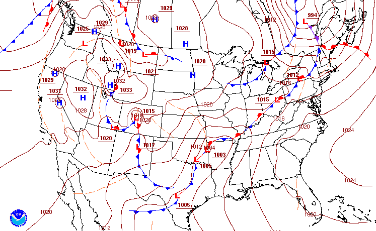
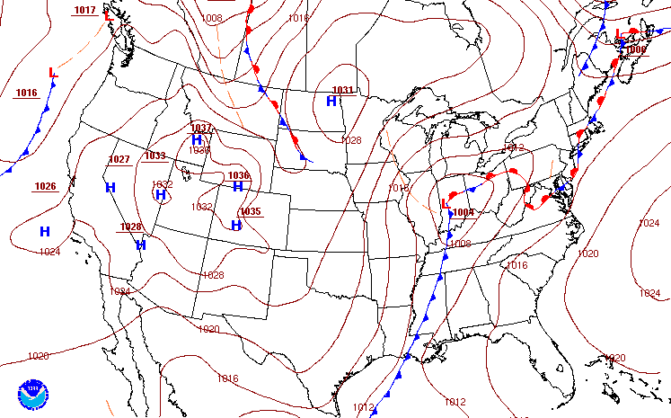
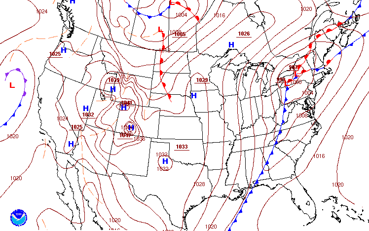
Surface/500mb/Precipitable Water Charts
 |
 |
 |
|
1 AM February 16th Surface Analysis Image courtesy of WPC (Weather Prediction Center) |
4 PM February 16th Surface Analysis Image courtesy of WPC (Weather Prediction Center) |
4 AM February 17th Surface Analysis Image courtesy of WPC (Weather Prediction Center) |
 |
 |
 |
|
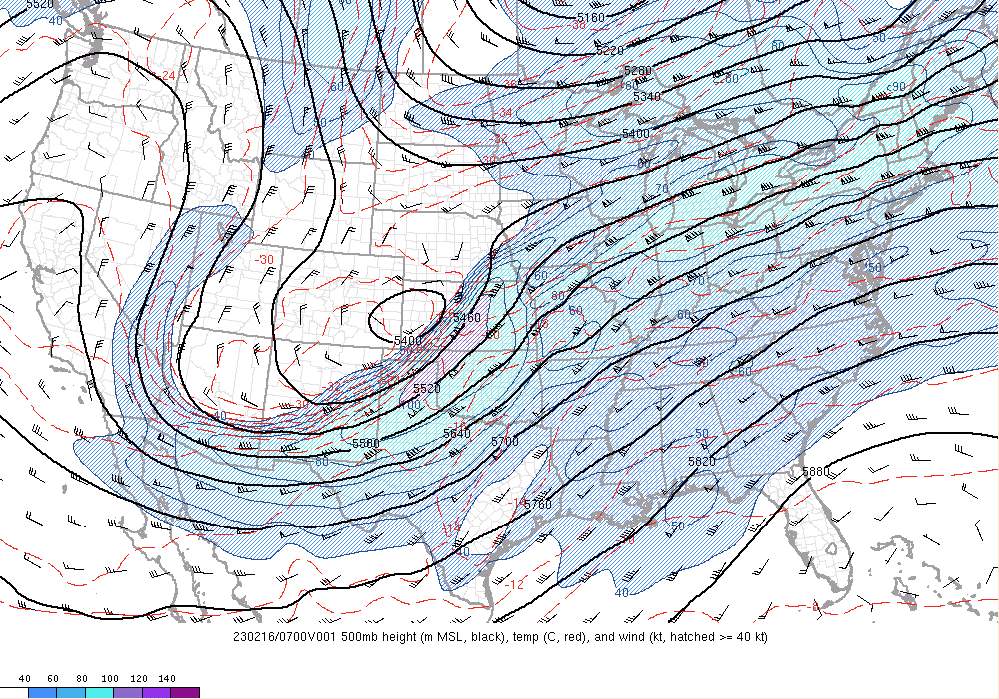
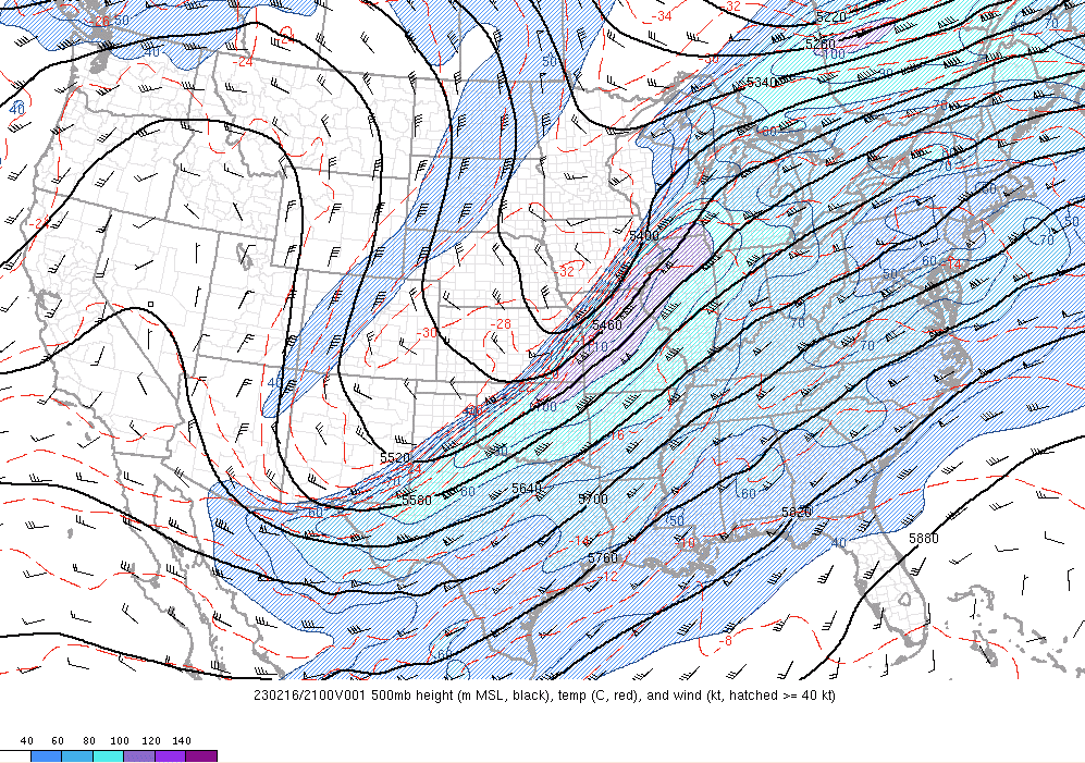
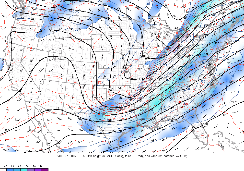
2 AM February 16th 500mb Chart Image courtesy of the Storm Prediction Center |
4 PM February 16th 500mb Chart Image courtesy of the Storm Prediction Center |
4 AM February 17th 500mb Chart Image courtesy of the Storm Prediction Center |
 |
 |
 |
|
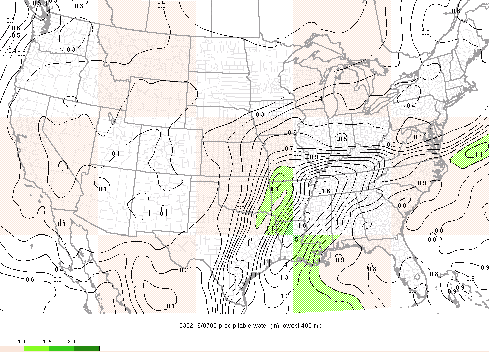
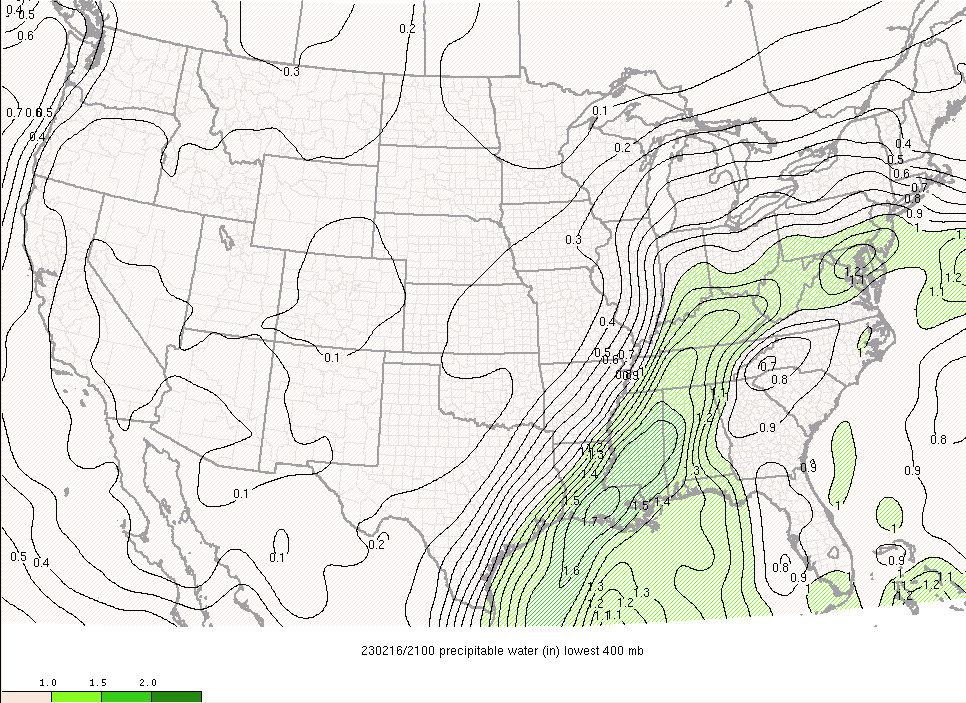
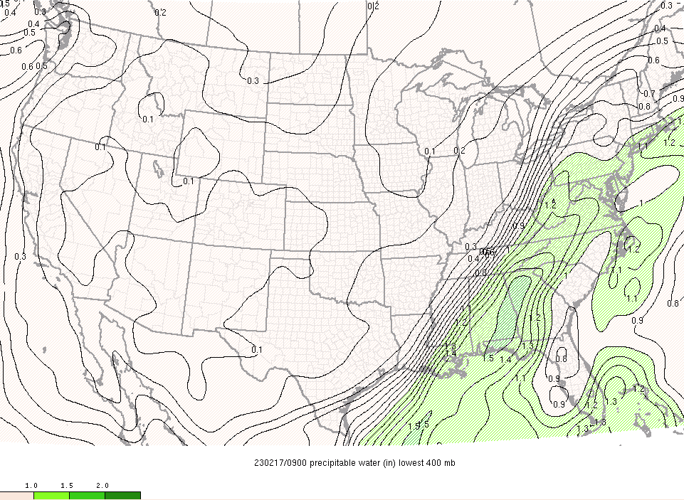
2 AM February 16th Precipitable Water Image courtesy of the Storm Prediction Center |
4 PM February 16th Precipitable Water Image courtesy of the Storm Prediction Center |
4 AM February 17th Precipitable Water Image courtesy of the Storm Prediction Center |
 |
Media use of NWS Web News Stories is encouraged! Please acknowledge the NWS as the source of any news information accessed from this site. |
|

