Severe Weather Episode Friday May 26th 2006
The combination of a cold front crossing during the afternoon hours and an upper level disturbance spawned numerous showers and thunderstorms along and east of the Ohio River Friday afternoon May 26th. A total of seven severe thunderstorm warnings were issued for counties in West Virginia between the hours of 2pm and 4pm. Quarter size hail was observed at the National Weather Service Office in Charleston, WV, while a microburst caused damage to several trees east of Charleston in the Kanawha City vicinity later in the evening. The Storm Prediction Center on its 1230 pm issuance outlooked much of West Virginia in a slight risk as pictured in Figure 1.
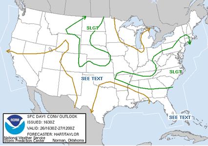
Figure 1 SPC day 1 outlook issued at 1630 Zulu
Below is a water vapor image taken at 1730 Zulu depicting an upper level disturbance passing through Ohio with thunderstorms developing out ahead. Darker shading over northern Kentucky and western West Virginia portrays drier mid levels of the atmosphere. Drier air would result in a chance of damaging winds due to evaporation of water further accelerating downdraft winds. Although gusty winds were observed with the storms, most reports relayed to the National Weather Service were nickel to quarter size hail.
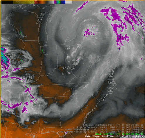
Figure 2 Water Vapor Image at 1730z
The surface map (Figure 3) analyzed by HPC has the cold front almost on top of the Ohio River at 18Z. If you compare the water vapor image above to the surface analysis, storms formed just ahead of the cold front.
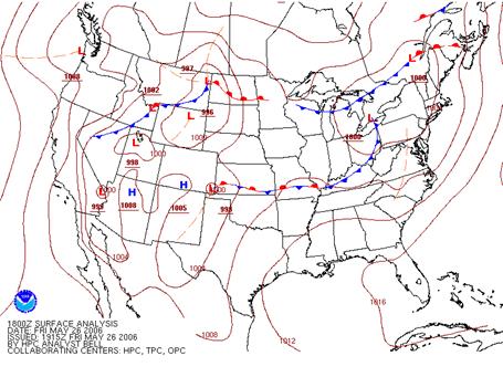
Figure 3 HPC surface analysis at 18z Friday May 26th 2006.
Although most of the morning was dominated by a canopy of clouds, sunshine broke through as mixing scoured out some of the clouds. The visible satellite image from 18Z shows scattered to broken cumulus clouds downstream of the front. In addition, it also shows towering cumulus clouds across West Virginia. The atmosphere was not as unstable in the mountains since little vertical growth in the cumulus clouds is indicated from Figure 4.
The corresponding surface map at 18z is shown in figure 5. It portrays moderate surface instability with temperatures in the lower to mid 70s and dewpoints in the lower 60s.
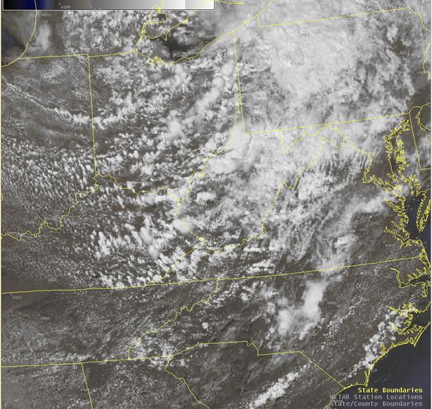
Figure 4 Visible Satellite Image taken at 18z Friday May 26th.
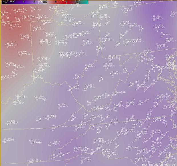
Figure 5 18Z surface map
The 0.5 degree reflectivity pictured below illustrates scattered to numerous showers and thunderstorms in the warm sector ahead of the front. The first severe thunderstorm warning was issued minutes after this image for Putnam and Kanawha counties. The storm is noted by the white arrow. Quarter size hail was reported in the town of Tornado in western Kanawha County, while nickel size hail fell in Putnam County.
Convective parameters used by meteorologists supported the threat of severe thunderstorms. Figure 6 is a sounding for Charleston and is the zero hour forecast from the 18Z NAM model. Surface based CAPE exceeded 1500 J/KG with little if any cap since negative energy was -25 J/KG.
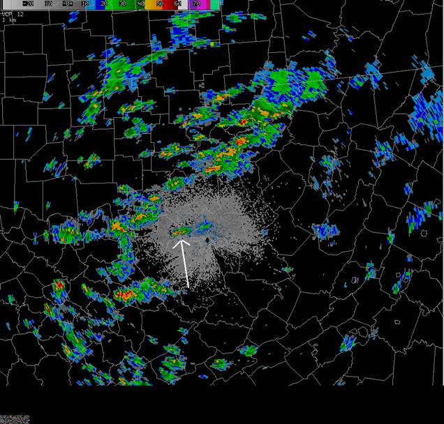
Figure 5 KRLX reflectivity taken shortly after 18z
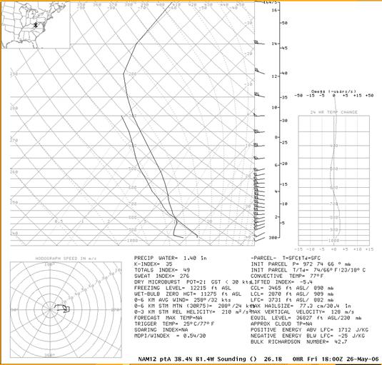
Figure 6 NAM zero hour forecast for Charleston valid at 18z Friday May 26th
By 19z storms continued to develop and move southeast through West Virginia. The 19z 0.5 degree reflectivity (figure 7) shows higher reflectivity values just east of the radar. This cell produced nickel to quarter size hail at the National Weather Service Office in Charleston.
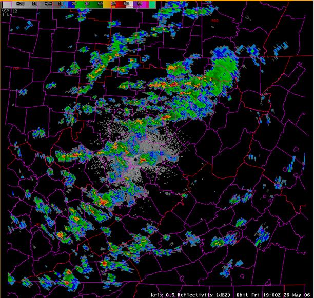
Figure 7 19z 0.5 degree reflectivity
The storms continue their eastward progression for the balance of the afternoon and weakened as they moved into more stable air in the West Virginia mountains. The final count of storm reports, wind or hail can be found below (figure 8). A complete listing of wind and hail reports relayed to the Charleston, WV forecast office can be found at the bottom of the page.
Figure 8 Storm reports for the calendar day of May 26th 2006
PRELIMINARY LOCAL STORM REPORT
NATIONAL WEATHER SERVICE CHARLESTON WEST VIRGINIA
241 PM EDT FRI MAY 26 2006
..TIME... ...EVENT... ...CITY LOCATION... ...LAT.LON...
..DATE... ....MAG.... ..COUNTY LOCATION...ST.. ...SOURCE....
..REMARKS..
0230 PM HAIL SAINT ALBANS 38.38N 81.83W
05/26/2006 U0.75 INCH KANAWHA WV PUBLIC
EVENT OCCURRED BETWEEN
215 PM 05/26/2006 AND 230 PM 05/26/2006
0240 PM HAIL TORNADO 38.33N 81.86W
05/26/2006 M1.00 INCH KANAWHA WV NWS EMPLOYEE
0242 PM HAIL SAINT ALBANS 38.38N 81.83W
05/26/2006 U0.88 INCH KANAWHA WV PUBLIC
EVENT OCCURRED BETWEEN
227 PM 05/26/2006 AND 242 PM 05/26/2006
0251 PM HAIL SAINT ALBANS 38.38N 81.83W
05/26/2006 U1.00 INCH KANAWHA WV PUBLIC
EVENT OCCURRED BETWEEN
236 PM 05/26/2006 AND 251 PM 05/26/2006
0250 PM HAIL CHARLESTON 38.35N 81.63W
05/26/2006 M1.00 INCH KANAWHA WV OFFICIAL NWS OBS
OBSERVED AT NWS OFFICE.
0250 PM HAIL SAINT ALBANS 38.38N 81.83W
05/26/2006 U0.75 INCH KANAWHA WV PUBLIC
EVENT OCCURRED BETWEEN
245 PM 05/26/2006 AND 300 PM 05/26/2006
0305 PM HAIL CHARLESTON 38.35N 81.63W
05/26/2006 E1.00 INCH KANAWHA WV PUBLIC
GREENVIEW ROAD AND SMITH CREEK
0308 PM HAIL CHARLESTON 38.30N 81.55W
05/26/2006 U1.00 INCH KANAWHA WV PUBLIC
EVENT OCCURRED BETWEEN
253 PM 05/26/2006 AND 308 PM 05/26/2006
0308 PM HAIL CHARLESTON 38.34N 81.66W
05/26/2006 U1.25 INCH KANAWHA WV PUBLIC
EVENT OCCURRED BETWEEN
253 PM 05/26/2006 AND 308 PM 05/26/2006
0308 PM HAIL CHARLESTON 38.30N 81.55W
05/26/2006 U0.88 INCH KANAWHA WV PUBLIC
EVENT OCCURRED BETWEEN
253 PM 05/26/2006 AND 308 PM 05/26/2006
0311 PM HAIL CHARLESTON 38.32N 81.59W
05/26/2006 U0.75 INCH KANAWHA WV PUBLIC
EVENT OCCURRED BETWEEN
256 PM 05/26/2006 AND 311 PM 05/26/2006
0314 PM HAIL CHARLESTON 38.35N 81.63W
05/26/2006 U0.88 INCH KANAWHA WV PUBLIC
EVENT OCCURRED BETWEEN
259 PM 05/26/2006 AND 314 PM 05/26/2006
0315 PM HAIL 3 S GRANTSVILLE 38.88N 81.09W
05/26/2006 E0.75 INCH CALHOUN WV TRAINED SPOTTER
0415 PM HAIL SUTTON 38.67N 80.71W
05/26/2006 E0.75 INCH BRAXTON WV TRAINED SPOTTER

