Wednesday May 31st 2006
The end of May brought the third and final day in a mini-heat wave across much of the mid-Atlantic. Afternoon and evening showers and thunderstorms dotted the radar screen. In some locations, high temperatures for the third consecutive day topped 90 degrees (table 1). Along with the very warm temperatures, low level moisture was high with surface dewpoints well into the 60s. An upper level high pressure parked over the eastern United States was the culprit for above normal temperatures during the latter part of May.
Table 1
|
Location |
5/29 |
5/30 |
5/31 |
|
Charleston |
91 |
93 |
92 |
|
Huntington |
91 |
92 |
92 |
|
Parkersburg |
89 |
91 |
90 |
|
Clarksburg |
89 |
92 |
91 |
In response to daytime heating, isolated showers and thunderstorms developed by late morning in the southern mountains of West Virginia then outflows from those thunderstorms spawned additional storms in the coal fields. Nine severe thunderstorm warnings were issued by the Weather Service Office in Charleston primarily for hail. The largest hail reported was 1.75 inches in the town of Julian in Boone County.
The radar image below was taken at 1830Z illustrating the scattered nature of storms.
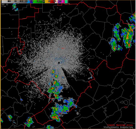
Figure 1 1830Z 0.5 degree reflectivity.
The next image shows a cross section of a severe thunderstorm that produced 1.5 inch hail in Logan County. The red indicates where hail is located in the storm. The hail descended minutes after this image was taken.
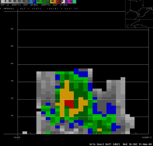
Figure 2 Reflectivity cross section of a severe thunderstorm in Logan County at 1830Z.
The following satellite image shows how isolated the storms were. Any location that was affected by a storm Wednesday afternoon received a healthy does of rain in addition to frequent lightning. With temperatures in the lower 90s and surface dewpoints in the 60s, the atmosphere was primed for thunderstorm development. The activity over eastern Ohio was in response to a weak boundary.
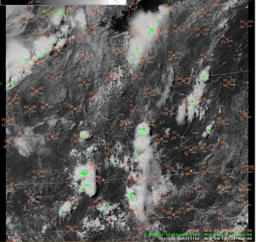
Figure 3 Visible satellite image at 1915Z
Below is a list of all the storm reports relayed to the National Weather Service in Charleston, WV
PRELIMINARY LOCAL STORM REPORT
NATIONAL WEATHER SERVICE CHARLESTON WV
1230 PM HAIL ANAWALT 37.33N 81.44W
05/31/2006 E0.75 INCH MCDOWELL WV POST OFFICE
0205 PM HAIL MILL CREEK 38.73N 79.97W
05/31/2006 M1.00 INCH RANDOLPH WV EMERGENCY MNGR
0245 PM HAIL SWITZER 37.79N 81.97W
05/31/2006 M1.50 INCH LOGAN WV POST OFFICE
0245 PM HAIL JULIAN 38.15N 81.85W
05/31/2006 M1.75 INCH BOONE WV POST OFFICE
0305 PM HAIL 4 W HARMAN 38.92N 79.60W
05/31/2006 E0.88 INCH RANDOLPH WV TRAINED SPOTTER
0416 PM HAIL SAINT ALBANS 38.38N 81.83W
05/31/2006 U0.25 INCH. KANAWHA WV PUBLIC
EVENT OCCURRED BETWEEN
401 PM 05/31/2006 AND 416 PM 05/31/2006

