|
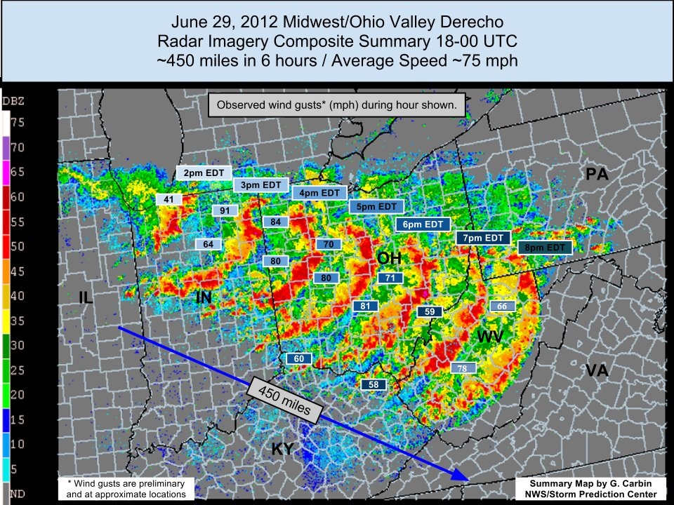
Most West Virginians know what the relatively obscure meteorological term "derecho" means. That's because of the impact that the June 29, 2012 Midwest/Ohio Valley Derecho had on their lives. Wind speeds that reached 60 to 80 mph knocked down trees and cut power to over 670,000 customers in West Virginia and over a million in Ohio at the peak of the event. In many cases it took over a week for utility companies to restore services. Compounding the situation, the derecho occurred during a period of intense heat which continued for several days afterwards making life difficult for those without electricity and air conditioning. Tony Cavalier, Chief Meteorologist from WSAZ-TV Huntington-Charleston, WV, said, "The derecho was one of the top two impacting events in my 25 year career."* * Quote included in The Historic Derecho of June 29, 2012 NWS Service Assessment.
|
 |
Meteorological Discussion
The June 29, 2012 derecho event that impacted the Mid-Atlantic/Ohio Valley region was one of the more unique warm-season events that impacted the lives of many. While there wasn’t any presence of a significant upper-level forcing mechanism, the excessive heat and humidity provided a very unstable environment to produce vigorous updrafts that spawned the severe storms. Temperature readings at both Huntington and Charleston recorded highs at 103 degrees (Fahrenheit), with the mountainous regions even reaching the lower 90s.
Beginning in the early hours of the 29th, convection moved from the Midwest into the Great Lakes with moderate divergent flow as the primary forcing mechanism along with dewpoints in the upper 50's. South of a west-east stationary front in the Ohio River Valley, deep surface moisture was in place with a persistent, stationary high pressure system over the southeast advecting moist Gulf air north into the Great Lakes and Appalachian regions. At 12z on the 29th, dewpoints in the gulf region were in the low 70's, and in the mid 60's across southeast Ohio and West Virginia.
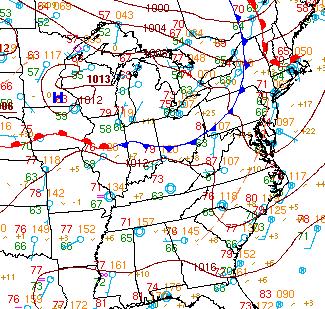
WPC surface analysis from 1200Z (8am EDT) 29 June 2012
The moderate divergent flow along and north of the stationary front steered the developing Mesoscale Convective System (MCS) through the southern Great Lakes by early afternoon.
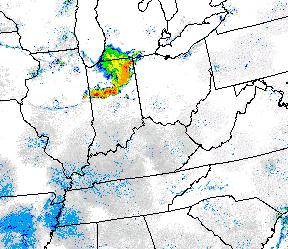
Composite radar data at 1900Z (3pm EDT) 29 June 2012
As the derecho took form in Ohio, the southwestern half of the convective line was being supported by steep lapse rates and strong moisture convergence. The northeastern half of the line continued to be forced by strong upper level flow. By late afternoon, the derecho had formed and was marching through southeast Ohio toward West Virginia.
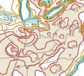
0-3 km lapse rate (C/km) at 2000Z (4pm EDT) 29 June 2012
As the line moved southeast, it shifted away from the stronger upper level forcing to the north and was firmly anchored in the lower troposhere, propagating southeast through southeast Ohio during the max heating of the day around 6pm.
Composite radar data at 2200Z (6pm EDT) 29 June 2012
Abundant surface moisture and heat, coupled with steep lapse rates and periodic storm mergers led to strong winds mixing quickly and violently to the surface. One particular case of storm merging led to some of the highest winds measured along the derecho.
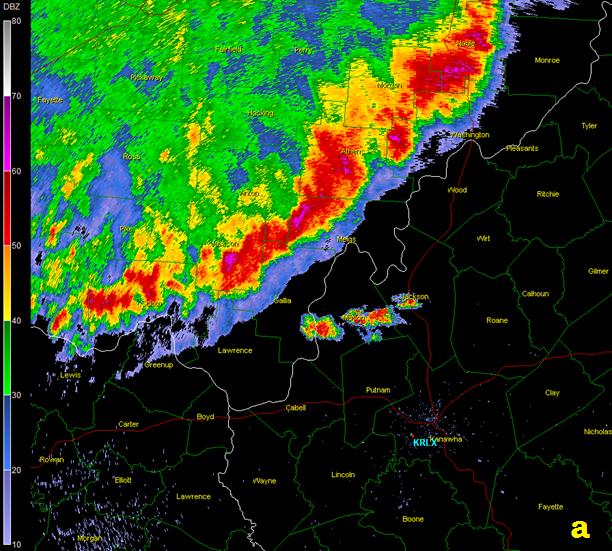
At approximately 6:20pm EDT a few leading cells developed over Mason and Jackson Counties in West Virginia (Fig 6a). At about 6:50pm, the leading gust front overran these cells and merged them into the much more dominant derecho.
 |
 |
| Base reflectivity data from KRLX at (a) 2218Z and (b) 2250Z. | |
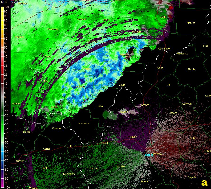
The base velocity data, for the same times shown above, indicates how the merging of these storms resulted in an even more powerful segment of the leading edge of the derecho. At approximately 6:20pm the velocities shown along the leading edge of the derecho were 55-75kts at about 4500ft above the ground. At that same time, the cells that developed ahead of the derecho in Mason and Jackson Counties had velocities of 5-15kts at about 2500ft above the ground (Fig. 7a). A half hour later, the velocities increased dramatically in the area of the merger; in northern Mason, western Jackson and northern Putnam Counties. Maximum velocities of 100kts peaked at about 2200ft above the ground.
 |
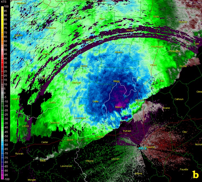 |
| Base velocity data from KRLX at (a) 2218Z and (b) 2250Z. | |
While some of the increase in velocities can be attributed to the leading edge moving closer to the radar resulting in acquisition of data nearer to the surface, the merging of these thunderstorms ultimately played an important role in bringing down even stronger winds to the surface. This enhanced section of the derecho eventually went over the ASOS at Yeager Airport in Charleston which measured a wind gust of 78mph. This was 10 mph stronger than any other measured location in our forecast and warning area.
Forecasting the Event
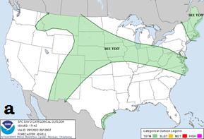
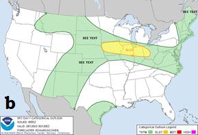
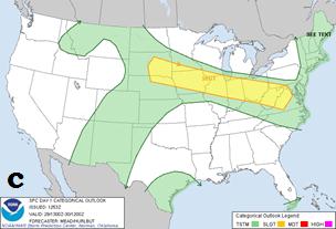
Derecho events test the limits of Numerical Weather Prediction modeling capabilities and are notoriously difficult to forecast with substantial lead times (>24hrs). The Convective Outlook products issued by the Storm Prediction Center further point to the difficulty in forecasting these high-impact events (see below). The Day 2 Convective Outlook issued the afternoon of the 28th displayed a broad area of general thunderstorms expected across the southern Great Lakes through the upper Ohio River valley. By the 0600Z (about midnight the day before) issuance of the Day 1 Convective Outlook, a slight risk of severe storms was identified but the middle Ohio Valley and central Appalachians were left out. At 1300Z (9am EDT) on the morning of the 29th, the slight risk was expanded to include the upper Ohio River valley and even stretched into VA. Finally, at 2000Z (4pm EDT) with the derecho in the early stages of its life cycle, much of the middle Ohio River Valley and central Appalachians were upgraded to a moderate risk.
 |
 |
 |
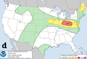 |
| Convective Outlooks from the Storm Prediction Center from (a) 1730Z 28 June (b) 0600Z 29 June (c) 1300Z 29 June (d) 2000Z 29 June. | |||
Locally, NWS Charleston's Area Forecast Discussion (AFD) issued at 1030am EDT 29 June stated that we were ‘very concerned’ about the system moving into our northern zones later that evening. For our 12:24pm AFD update, we expressed our increased confidence in severe parameters and were highlighting the wind threat. The first Mesoscale Discussion issued by the Storm Prediction Center mentioning our CWA was issued at 1:01pm EDT and discussed the small MCS over IN evolving with an increasing severe wind/hail threat. This was also the first mention of the need for a Severe Thunderstorm Watch into our forecast and warning area.
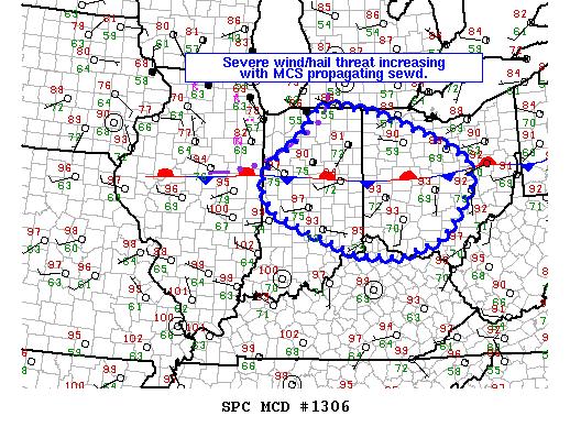
Mesoscale Discussion issued by SPC at 1801Z (1:01pm EDT) 29 June 2012.
At 3:05pm EDT, a Severe Thunderstorm Watch was issued for southeast OH, western WV, and northeastern KY. The Watch parameters showed a high threat for severe wind including wind greater than 65kts. This Watch would be later expanded to include the rest of our forecast and warning area.
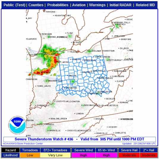
Severe Thunderstorm Watch #436 issued at 1905Z (3:05pm EDT) 29 June 2012.
As the derecho passed through our region, NWS Charleston, WV issued 12 Severe Thunderstorm Warnings. The first warning was issued at 5:12pm EDT for Athens, Perry & Morgan Counties in southeast Ohio. The last warning issued at 8:28 EDT was for Pocohantas County, as the line of storms moved into Virginia. Every county in our area of responsibility was in a warning at some point during the event.
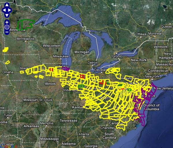
All warnings issued by various National Weather Service offices for the derecho on 29-30 June 2012.
Storm Reports
The derecho traveled 700 miles in just a span of 12 hours, tracking southeastward through most of Ohio, West Virginia, portions of Pennsylvania, Virginia, Maryland, Washington D.C., New Jersey, Delaware, and even into North Carolina before drifting off into the Atlantic shortly after midnight on June 30th. The Storm Prediction Center recorded a total of 1264 storm reports on June 29th, nearly all of which stemmed from the derecho. Here's a look a the measured wind gusts from the storms in the NWS Charleston, WV forecast and warning area:
| Measured wind gusts from the NWS Charleston, WV Forecast and Warning Area | |||
|
Time (EDT) |
Location |
County, State |
Wind Speed (MPH) |
|
550pm |
New Lexington OH ODOT |
Perry County, OH |
62 |
|
612pm |
OU Mesonet-Athens |
Athens County, OH |
64 |
|
615pm |
UNI-Athens OH |
Athens County, OH |
59 |
|
631pm |
Gallopolis OH DOT |
Gallia County, OH |
62 |
|
658pm |
HTS-Huntington, WV |
Wayne County, WV |
59 |
|
710pm |
CRW-Charleston, WV |
Kanawha County, WV |
78* |
| * Hanger was damaged and small, single engine plane was flipped on the tarmac. | |||
|
728pm |
CKB-Clarksburg, WV |
Harrison County, WV |
66 |
|
757pm |
EKN-Elkins, WV |
Randolph County, WV |
64 |
|
807pm |
BKW-Beckley, WV |
Raleigh County, WV |
68 |
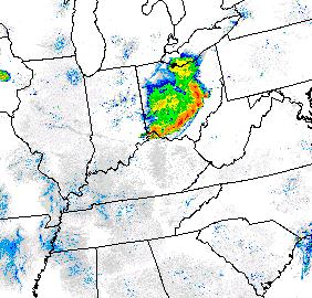
An estimated 3.7 million customers were without power as a result of the derecho. 1 million of which were in Ohio, and another 670,000 or so customers were without power in West Virginia. In many cases, it took over a week for outages to return to near normal levels. NWS Charleston was not immune. Despite backup generators to protect our equipment, communication was very difficult, and we received support from our neighboring NWS offices in Pittsburgh and Jackson, KY in the days that followed. With the damage to the power grid and cellular telephone infrastructure, receiving storm reports became increasingly difficult in central and eastern West Virginia. This is the primary reason why a “data hole” appears in the storm reports over WV in the map of storm reports below.
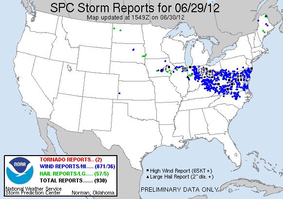
Local storm reports plotted for 29 June 2012 from the Storm Prediction Center.
Derecho Criteria
Criteria for a Mesoscale Convective System to be classified as a derecho: Johns and Hirt (1987)
 |
Media use of NWS Web News Stories is encouraged! Please acknowledge the NWS as the source of any news information accessed from this site. |
|

