Public Information Statement
National Weather Service Charleston WV

..........NEAR NORMAL TEMPERATURES THIS JUNE WITH VARYING PRECIPITATION DEPARTURES...........

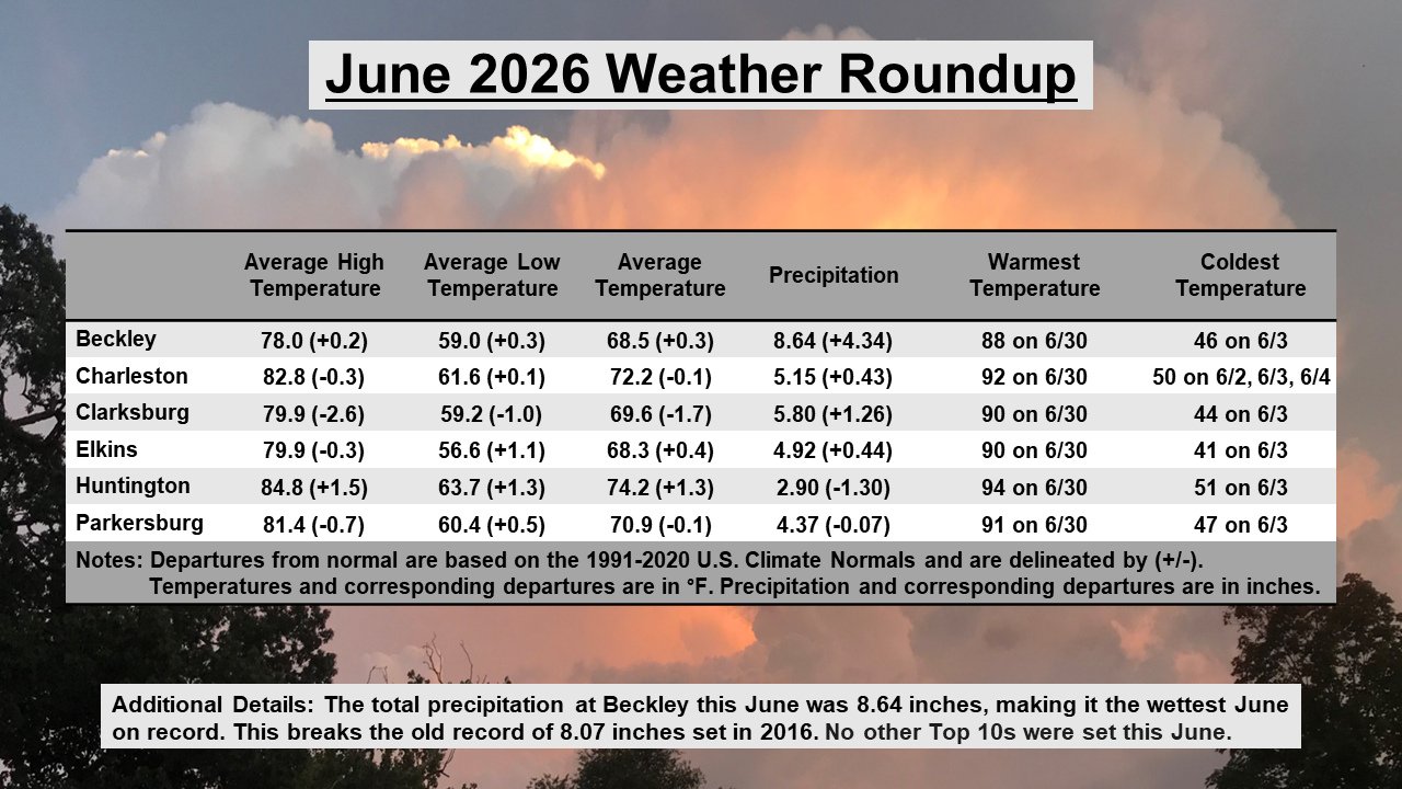
Compared to historical records and the 1991-2020 U.S. Climate Normals, mean temperatures
this June were near normal across the NWS Charleston forecast area, ranging within two
degrees above or below normal. No Top 10s were set at any of the official NWS Charleston
climate locations this June in terms of mean temperatures.

As is typical during the summer months, precipitation totals this June across the forecast
area varied significantly depending on location, ranging anywhere from approximately 1 to 9
inches. This resulted in a wide range of departures, with some locations more than 3 inches
below normal, while others ended up over 4 inches above normal. For instance, only 1.38 inches
of precipitation was observed at the Cooperative Observer station in South Point, Ohio, which
was 3.16 inches below normal. On the other end of the spectrum, 8.64 inches was observed in
Beckley, West Virginia at the Raleigh County Memorial Airport, which was 4.34 inches above
normal. In fact, this was the wettest June on record for Beckley, breaking the old record of
8.07 inches set in 2016. No other Top 10s were set at any of the other official NWS Charleston
climate locations this June in terms of precipitation.



 Radar
Radar Current Weather
 Rivers & Lakes
 Satellite
 Forecast Maps
 Hour by Hour Forecast
 Tropical Weather
 Graphical Hazards
 Weather Hazard Briefing
 Forecaster's Discussion
 Text Bulletins
 Climate Plots
 Aviation Weather
 Fire Weather
 Drought
 Submit Storm Report
 Weather Spotters
 NOAA Weather Radio
 Follow us on X
 Follow us on Facebook
 RLX RSS Feed