Overview
In the early morning hours of Thursday, March 18th a line of severe thunderstorms moved across the area ahead of a cold front, producing several tornadoes across Southeast Alabama, the Florida Panhandle, and Southwest Georgia. Overall, at least 6 tornadoes were confirmed through NWS survey work. Four of the tornadoes have been rated EF-1, with two additional tornadoes rated EF-0.
Images on this site can be magnified. Click in a image to magnify it, and then click it again to return it to its normal size.
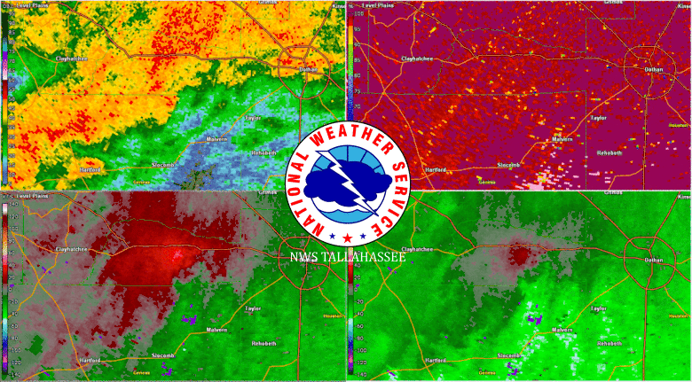 |
| Radar imagery from the strongest storm of the morning, an EF-1 tornado that impacted parts of west Dothan. The animated image above followed the circulation that ended up having two tornadoes one after another as it moved towards Henry County. The top left image is reflectivity, the top right is correlation coefficient, the bottom left is storm relative velocity, and the bottom right is regular velocity. Image from the Ft. Rucker Radar (KEOX). |
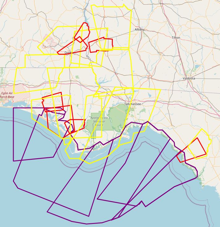 |
| Regional overview of the warnings our office issued during this severe weather event. Red boxes are tornado warnings, yellow are severe thunderstorm warnings, and purple are special marine warnings. |
Storm Information
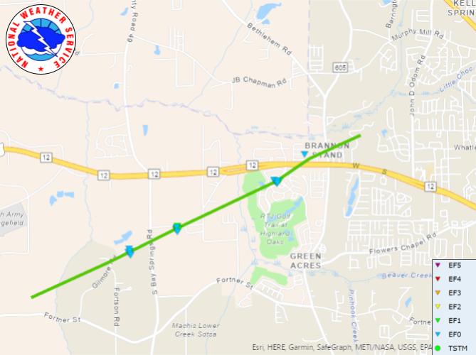
Tornado - Dothan (Houston County)
Alabama
| Date |
March 18, 2021 |
| Time |
5:26 am - 5:37 am CT |
| EF Rating (Max) |
1 |
| Est. Peak Winds |
100 mph |
| Path Length |
5.26 miles |
| Max Width |
150 yards |
| Injuries/Deaths |
1 injury |
|
Summary: The tornado first began east of Wicksburg and east of the Houston/Geneva county line where scattered tree limbs where reported by the emergency manager. The tornado then strengthened and hit several structures on a farm where damage was confined to ripped roof paneling and other similar damage. The tornado then traveled northeast towards US-84. It was in these locations that the tornado was likely at its peak strength as it moved across Marshall Rd and into the Highlands Subdivision along Highway 84. Along Marshall Rd, a double wide sustained significant roof covering loss, a large carport over a RV was completely destroyed, and a out building nearby was missing nearly its entire roof with some walls partially collapsed. The tornado also briefly picked up a boat, with trailer, and rolled/rotated it 180 degrees on the trailer before being laid to rest nearly 75-100 yards from its original location. EF-1 damage was again observed in the Highlands Subdivision south of US Highway 84. Two homes sustained roof damage with one home sustaining partial roof loss on the second story. Many pine trees near this house were also snapped or uprooted. While these were the only homes with notable damage in the community, there was a path of widespread tree damage through the rest of the neighborhood. The tornado then crossed US-84 where damage became more isolated with a few downed trees and broken branches. The tornado is then estimated to have lifted just northeast of North Brannon Stand Rd. The NWS thanks Houston County EM Chris Judah for his assistance during this survey.
|
Track Map
|
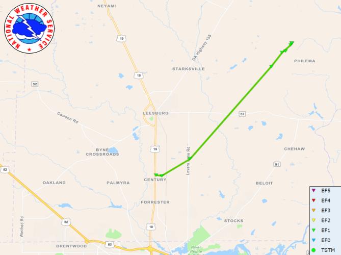
Tornado - Lee County
Georgia
| Date |
March 18, 2021 |
| Time |
9:06 am - 9:17 am ET |
| EF Rating (Max) |
1 |
| Est. Peak Winds |
100 mph |
| Path Length |
10.63 miles |
| Max Width |
50 yards |
| Injuries/Deaths |
0 |
|
Summary: This tornado touched down near the intersection of U.S. Route 19 and Century Road East where a pine tree was snapped. Further east on Century Road, the tornado snapped another large pine and did considerable structural damage to the property. About 60% of the roof of well-built home was removed. A substantial carport was ripped off the home and tossed several feet. One wall segment of a large garage was sucked outward. The tornado did not do any appreciable damage to houses to the right or left of this residence. After moving over an unpopulated swamp area, the tornado snapped several softwood pines and uprooted several large hardwood trees at 669 Lovers Lane Road. The tornado crossed another sparsely populated swampy area and may have briefly lifted before uprooting more trees on Middle Road North. These were felled in crosswise fashion. The final damage area was on New York Road. A large live oak tree was uprooted and fell into a home. Several other large trees on the property were also uprooted. Just up the road, the tornado was sighted by a homeowner as it crossed their property, destroying a shed, tossing a trampoline and snapping a pine tree. The tornado then likely lifted over an open field beyond this property as no further damage was noted northeast of New York Road. Damage along the entire route was consistent with an EF-1 tornado with tops winds of 100 mph.
|
Track Map
|
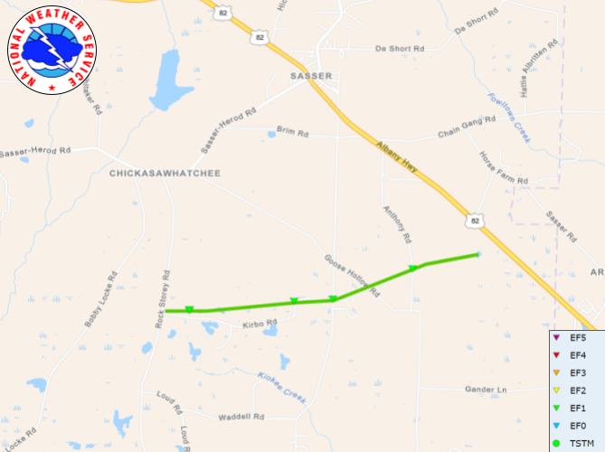
Tornado - Terrell County
Georgia
| Date |
March 18, 2021 |
| Time |
8:46 am - 8:52 am ET |
| EF Rating (Max) |
1 |
| Est. Peak Winds |
90 mph |
| Path Length |
4.05 miles |
| Max Width |
200 yards |
| Injuries/Deaths |
0 |
|
Summary: EF1 Tornado touchdown in Terrell County. Damage was initially reported along Kirbo Road where there was roof damage to one single family home. Numerous pines in the yard were snapped or uprooted at this residence. Further east on Kirbo Road, additional pine trees were snapped or uprooted. More trees were observed uprooted or snapped along Florida Short Route just to the northeast of Kirbo Road. No structures were damaged in this area. The tornado again snapped or uprooted several trees along Anthony Road. The tornado lifted before reaching US-82. NWS Tallahassee extends our appreciation to Terrell County Emergency Management for their assistance in this damage survey.
|
Track Map
|
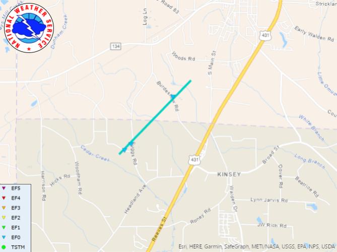
Tornado - Houston/Henry Counties
Alabama
| Date |
March 18, 2021 |
| Time |
5:49 am - 5:52 am CT |
| EF Rating (Max) |
0 |
| Est. Peak Winds |
80 mph |
| Path Length |
2.08 miles |
| Max Width |
50 yards |
| Injuries/Deaths |
0 |
|
Summary: An EF-0 tornado touched down in northwestern Houston County near Cedar Creek. Small trees and branches were snapped along Faulkner Rd and Suggs Rd. A carport on Suggs Rd sustained damage. The tornado then tracked northeast into Henry County, snapping some small trees and branches along Burdeshow Rd before lifting just south of Headland.
|
Track Map
|
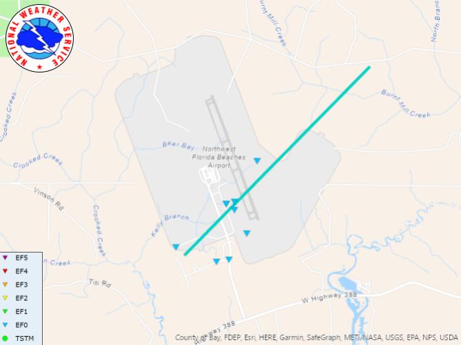
Tornado - NW Florida Beaches International (Bay County)
Florida
| Date |
March 18, 2021 |
| Time |
6:03 am - 6:04 am CT |
| EF Rating (Max) |
0 |
| Est. Peak Winds |
85 mph |
| Path Length |
3.94 miles |
| Max Width |
100 |
| Injuries/Deaths |
0 |
|
Summary: This tornado touched down just south of the Northwest Florida Beaches International Airport with most damage occurring on the airport property. A few small pine trees were snapped on Johnny Reeves Road and Venture Crossings Blvd. A ground-level metal sign was bent over 90 degrees at the intersection of Venture Crossings Blvd. and West Bay Parkway. At the Sheltair FBO, a Citation aircraft spun 90 degrees with the nose damaging an adjacent plane, which was spun 20 degrees. Other smaller planes were shifted further north on the property near an area of hangars. One hangar lost a small section of roof and had the door damaged. Wind entering the hangar did considerable damage to one of the antique cars being stored there. The metal door track punched a hole through the wall of the hangar. Another hangar also suffered minor roof damage. Finally, the KECP ASOS measured a gust to 82 mph as the tornado passed by. The tornado then tracked a couple of miles northeast of the airport property through uninhabited terrain before lifting. Damage along the path, and the measured gust, are consistent with high-end EF-0 damage.
|
Track Map
|
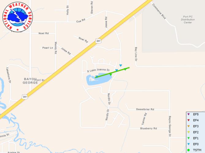
Tornado - Bayou George (Bay County)
Florida
| Date |
March 18, 2021 |
| Time |
6:25 am - 6:26 am CT |
| EF Rating (Max) |
1 |
| Est. Peak Winds |
95 mph |
| Path Length |
0.37 miles |
| Max Width |
50 yards |
| Injuries/Deaths |
0 |
|
Summary: The tornado touched down along the north shore of a small lake near S. Lake Joanna Dr. and Sweet Lane. The tornado travelled east-northeast across the lake, producing EF-1 damage to a home at the northeast end of the lake in the 7300 block of S. Lake Joanna Dr, including removal of a back porch canopy roof and causing a sizable opening in the main roof of the home. Debris from this house peppered another nearby home, with two 2x4s puncturing its back porch awning. The tornado crossed east-northeast across Bayou George Dr. On the other side of Bayou George Dr. the tornado hit a PODS storage yard, where PODS were originally in 3-high stacks. Some of the PODS shifted, and one POD unit was tossed. The tornado then lifted. Tornado damage at the home at the east-northeast end of the lake in the 7300 block of S. Lake Joanna Drive is consistent with a tornado of EF-1 strength.
|
Track Map
|
The Enhanced Fujita (EF) Scale classifies tornadoes into the following categories:
EF0
Weak
65-85 mph |
EF1
Moderate
86-110 mph |
EF2
Significant
111-135 mph |
EF3
Severe
136-165 mph |
EF4
Extreme
166-200 mph |
EF5
Catastrophic
200+ mph |
 |
A .KMZ file outlining details of these surveys, including several photos not shown here, can be found by clicking here.


