Hurricane Idalia Strikes the Florida Big Bend
August 30, 2023
Additional More In Depth information on idalia available through story map here
Overview
Hurricane Idalia had its origins from an area of disturbed weather that began over the eastern Pacific and central America around August 23rd. Through the next two to three days the area of disturbed weather would slowly drift northeast into the northwestern Caribbean Sea while slowly organizing. On August 26th around 5 pm EDT, a tropical depression formed as the National Hurricane Center determined a closed circulation had developed. From Saturday August 26th through early Monday morning of the 28th, Idalia would slowly meander through the northwestern Caribbean Sea, and it became a tropical storm on Sunday morning around 11 am EDT. By early Monday morning, Idalia began its northward turn and after crossing the western tip of Cuba Monday night, Idalia would rapidly intensify from a tropical storm into a major hurricane on Tuesday ahead of an eventual landfall near Keaton Beach, FL just before 8am EDT Wednesday.
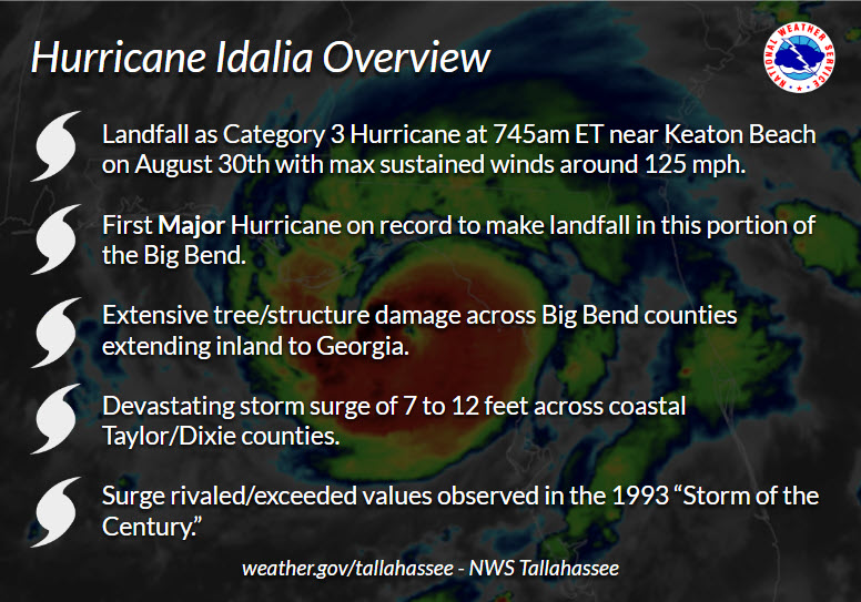
Idalia's primary impact was devastating storm surge across the coastal Big Bend in Levy, Dixie, and Taylor counties. Storm surge inundations of 7 to 12 feet along the coast were some of the highest values recorded since the 1993 Storm of the Century. In some locations, according to local residents, values exceeded those observed in the 1993 Storm of Century. Idalia moved ashore during low tide, and if not for that storm surge values could have easily been 3 to 4 feet higher had Idalia moved onshore only 4 to 6 hours later at high tide. In addition to surge, wind and flooding damage was recorded well inland into Georgia. As radar animations will show later on this page, wind impacts were likely tempered somewhat by the fact that Idalia's inner core was quickly degrading as it underwent an eye wall replacement cycle immediately prior to landfall.
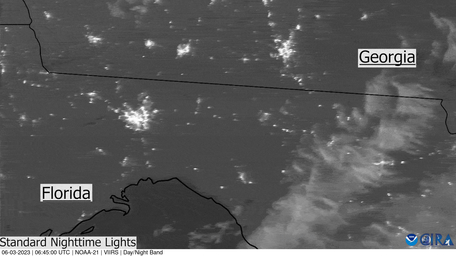
| Satellite Loop of Hurricane Idalia Courtesy of NOAA/CIRA |
Early Life
Idalia began as an area of disturbed weather off the coast of Central America on August 23rd. This area was identified as an area to watch for new development from the Hurricane Center late in the evening on August 23rd via the tropical weather outlook. Over the next 48 to 72 hours Idalia would move across Central America and into the northwestern Caribbean with convection generally lacking as the broad mid-level circulation lifted north. During the afternoon of Saturday August 23rd, Idalia would eventually develop a closed circulation and improve in appearance as convection slowly organized around the center.
 |
| Figure 2: The first Tropical Weather Outlook (TWO) for the area (yellow) that would eventually become Idalia. |
From Saturday afternoon through early Monday morning (28th), Idalia would meander across the northwestern Caribbean Sea. This was primarily due to very weak steering currents aloft. Northerly shear over the system through much of Sunday and into early Monday led to convection routinely firing on the southern side of the circulation and helped Idalia drift south through this period. Additionally, the northerly shear and drier air to the north of Idalia from Saturday night into early Monday led to a very slow intensification of the storm through the weekend. It wasn’t until a large burst of convection Sunday night did we see Idalia begin to have an uptick in intensity.
Idalia Turns North and Rapidly Intensifies
By Monday (28th) morning, satellite fixes and airplane reconnaissance indicated that Idalia finally started its northward turn with the 11am advisory indicating a northward motion around 8 mph. Despite a visual improvement in the storm on satellite imagery, airplane reconnaissance was finding that Idalia was still feeling the effects of north/northwesterly shear, and the central pressure had not lowered significantly overnight. As the storm passed the western tip of Cuba and moved into the southern Gulf of Mexico Monday night, the storm had still not yet developed the intensity to be labeled a hurricane. However, continued aircraft passes into the storm through the day, and radar data from nearby Cuba, indicated that Idalia was beginning to pick up in intensity. Its center pressure fell, especially late in the afternoon and overnight hours, as more impressive curved bands around the center developed. By early Tuesday morning with the 5am advisory, Idalia became a hurricane in the southern Gulf of Mexico.
With wind shear beginning to let up, and Idalia moving into a favorable environment Tuesday (29th) with very warm sea surface temperatures (SSTs), this would set the stage for rapid intensification. Max sustained winds were at 75 mph with the 5am advisory early Tuesday morning, but Idalia would eventually reach 100 mph max sustained winds by 5pm advisory 12 hours later with the rapid intensification showing no signs of letting up. As Idalia crossed the latitude of Tampa, FL just after sunset, an eye began to form. Through Tuesday night and into the early hours of Wednesday (30th) morning Idalia would continue to rapidly intensify.
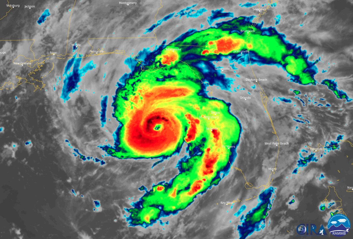 |
| Figure 3: Hurricane Idalia on Tuesday night as it rapidly intensified. |
Idalia Turns North and Rapidly Intensifies
By bedtime for many along the northeast Gulf Coast, all attention was on Idalia as rapid intensification continued. By the 11pm advisory on Tuesday night, approximately nine hours before landfall, Idalia was a strong category two hurricane with max sustained winds of 110 mph. With the 11 pm advisory, Idalia finally began to make its predicted northeast turn, but for a few hours after the 11pm advisory the storm gained little eastern longitude, and as the 2am intermediate advisory came in and the storm strengthened into a major hurricane with max sustained winds of 120 mph. At 5am Wednesday morning, approximately 3 hours before landfall, Idalia continued its rapid intensification and became a Category 4 hurricane when aircraft reconnaissance found evidence to support max sustained winds of 130 mph in Idalia. Between the 2am and 5am advisories, Idalia made its forecasted northeast turn and was now on a heading towards the southeast coastline of the Florida Big Bend.
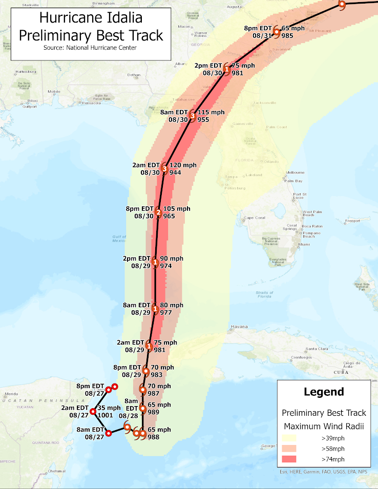 |
| Figure 4: Preliminary track and intensity of Hurricane Idalia |
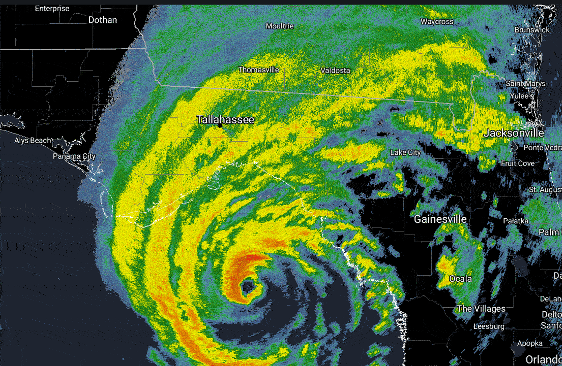
As Idalia moved towards the coastline between the 5am advisory and landfall, the storm began to show signs of what meteorologists call an “eye-wall replacement cycle” (ERC). An ERC can be associated with a reduction in the maximum winds at the center of a storm as a new eye-wall, located further away from the center of the storm, attempts to build. The ERC caused a slight weakening of Idalia at landfall, and radar imagery before landfall clearly showed the open eye wall to the southeast, and a concentric band of convection well away from the inner eye-wall. While an ERC might've spared even more catastrophic damage from occurring via Idalia’s winds, it wasn't enough to mitigate the impacts from storm surge, heavy rainfall, and wind, especially just after landfall. Around 745 am ET the National Hurricane Center declared that Idalia had made landfall near Keaton Beach, Florida.
 |
|
Figure 5: Hurricane Idalia at 5am just before landfall on Wednesday August 30, 2023 |
The hour or two before/after landfall is when the greatest impacts from Idalia were felt along the coast. Storm surge flooded in, and there were many observations all across the Big Bend and Nature Coast of life-threatening storm surge while hurricane force gusts lashed the coastline and interior portions of the coastal Big Bend. As Idalia moved inland, strong winds in the western eye-wall spread inland across Florida, in addition to very heavy rainfall rates. As Idalia went into Georgia, parts of southwest/south-central Georgia received numerous reports of flash flooding in addition to frequent tropical-storm force gusts.
As Idalia moved into Georgia by the early afternoon, it would only accelerate. For much of the forecast area, the direct threat from Idalia was over by the early afternoon, with the threats from Idalia ending in Georgia Wednesday evening when all tropical storm and hurricane warnings were canceled with the 5pm advisory. We’ll detail some of the damage for each of the hurricane hazards (wind, surge, rainfall) in the Impacts tab above. Our thoughts are with all those affected by this storm.
 |
|
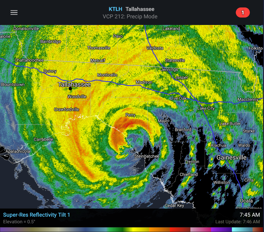
Figure 6: Hurricane Idalia at 745am during landfall on Wednesday August 30, 2023 |
Storm Surge
Hurricane Idalia made landfall at 745 am ET on Wednesday, August 30th near Keaton Beach, Florida with maximum sustained winds of 125 mph. The hurricane produced a devastating surge along coastal communities in Taylor and Dixie Counties within our county warning area. The peak surge values observed were from Dekle Beach in Taylor County southeastward to Horseshoe Beach in Dixie County. Surge heights in this area along the immediate coast were within the range of 7 to 12 feet above normally dry ground. Lower values of up to 6 feet above normally dry ground were noted south of Horseshoe Beach near the community of Suwannee.
Storm surge is measured above normally dry ground. Numerous homes within the surge zone suffered significant damage or had water and debris marks on them where survey field crews could make a determination of both the still and wave water level. It is important to stress that field crews work to differentiate between the still water level, that is, the water level rise above normally dry ground, which is storm surge, and wave action. Wave action, on top of the storm surge, is also measured. In this event, wave action was generally found to average around 3 feet on top of the peak storm surge.
 |
 |
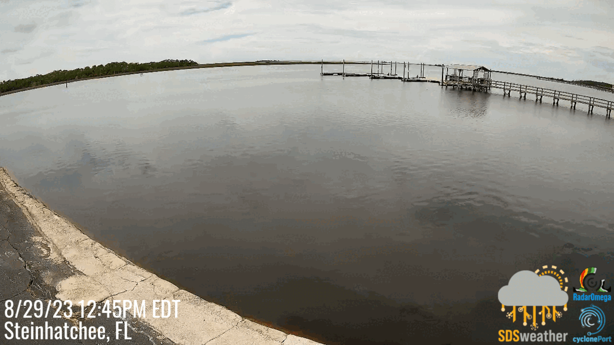
| Before and after view of the storm surge that occurred in Steinhatchee, FL. Camera stills provided by https://www.radaromega.com/ | Storm surge moves up the Steinhatchee River just after landfall of Idalia. Video from: https://www.news4jax.com/ |
One of the more notable features of Idalia's landfall was the timing. Tidal ranges in the Apalachee Bay have very large swings, often around three to four feet most times of the year. The landfall of Idalia occurred approximately around low tide and if the storm had made landfall at high tide later in the day, water levels would likely have been 3 to 4 feet higher.
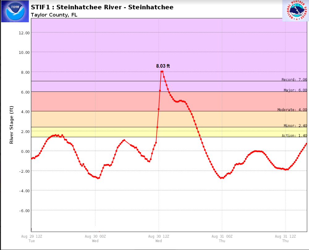 |
| Figure 1. Hydrograph at the Steinhatchee River. This shows the rapid rise of surge. Each dot in the hydrograph is spaced 15 minutes apart. The water level from Idalia at this river gauge rose nearly 8 feet in approximately an hour. |
Comparisons to 1993 "Storm of the Century."
In the process of the high water mark surveys, interviews were conducted with several residents that lived in the area during the "Storm of the Century,” a non-tropical system that affected this portion of the Florida coastline on March 13, 1993. All of these residents interviewed from Keaton Beach to Horseshoe Beach indicated water levels that rivaled or exceeded those experienced in the 1993 “Storm of the Century.” Moreover, Dixie County Emergency Management noted that the inland extent of the storm surge from Hurricane Idalia moved much further inland from Horseshoe Beach than observed in “The Storm of the Century.” We greatly appreciate these interviews and are continuing to compare these statements with the high water marks collected from Hurricane Idalia with the storm surveys completed following the 1993 “Storm of the Century”.
Wind Impacts
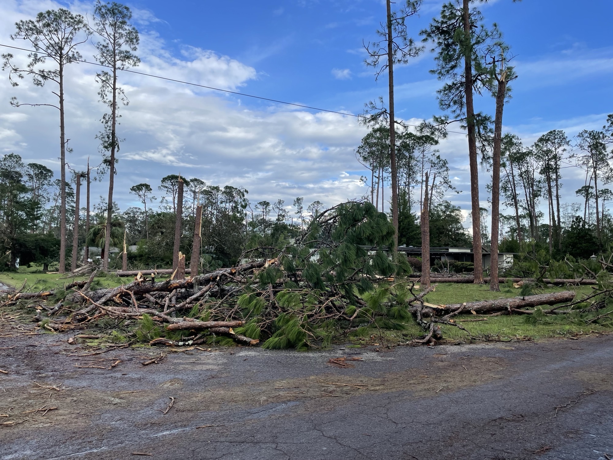
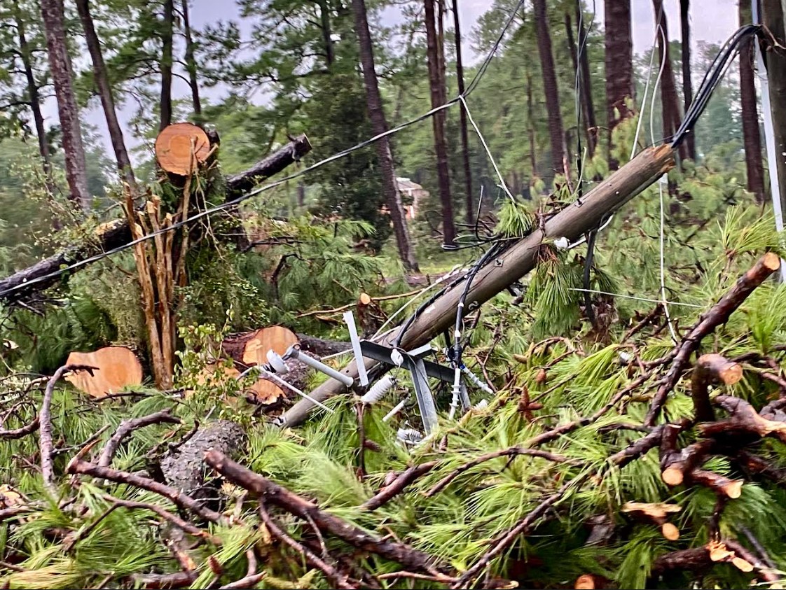
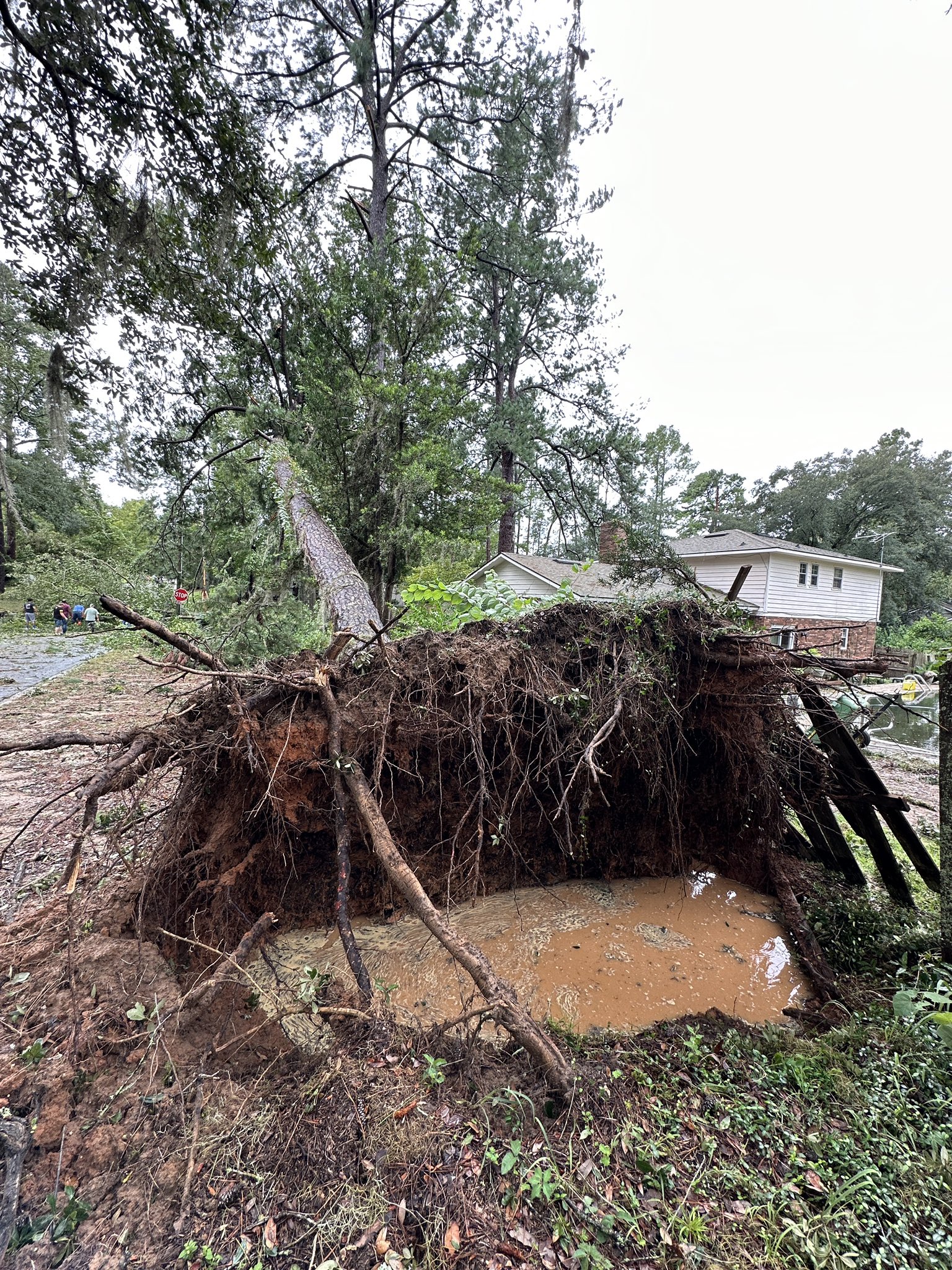
Wind was also a prominent impact during Idalia. The most extensive wind damage occurred across the southeast portions of the Florida Big Bend. While max sustained winds observed across the area were not as high as 125mph listed on National Hurricane Center advisories, it's important to note that these highest winds are typically very localized, and usually occur at/over water. Additionally, the observation network across this portion of Florida is not as dense as other parts of the United States. A few weather stations also likely did not measure peak winds as they either failed before the max winds arrived, or power/comms outages limited the the ability to measure the peak. With that said, damage to the timber was still extensive and power outages across much of the Big Bend were at or near 100%. The greatest wind impacts felt were across nearly all of Taylor, Madison, Lafayette, counties with more scattered/isolated impacts in eastern portions of Jefferson, Leon, Wakulla counties. A common scene across these heavily damaged areas was "moderate to severe damage" across the timber industry and numerous pictures on social media and other media outlets showed scenes where no tree was left unaffected. Damage continued up into Georgia with the heaviest damage being centered along/around the path where the remnant portions of the eye wall moved through. Georgia Forestry noted (see report linked in Figure 2) that the most significant timber damage was across southern Georgia in/near Valdosta and extending to Waycross. The greatest damage was typically in urban areas and in the vicinity of field/road edges per the Georgia Forestry assessment.
Despite the heavy damage to trees, and numerous structures in Taylor/Madison/Lafayette counties, winds could have been worse if not for the eyewall replacement cycle Idalia appeared to go through immediately prior to landfall. This was noted on radar imagery as the southeastern portions of the eyewall became very ragged, and almost non-existent at landfall. While an eyewall replacement cycle can lead to an increase in wind radii of a storm, this process takes time and typically the first impact of a eyewall replacement cycle is a reduction in the winds and increase in central pressure. This likely took an edge off the winds, sparing even greater potential damage, but it was still not enough to spare the region from frequent 80 to 90 mph gusts. Idalia's relatively fast forward motion also allowed little time for the winds to reduce which allowed widespread 60 to 70 mph wind gusts to spread into southern Georgia from Valdosta to Waycross.
 |
 |
|
An example of the extensive tree damage in Taylor County. Image: Taylor County Emergency Management. |
A twisted heap of power lines and felled pine trees in/near Valdosta. Image: Lowndes Emergency Management Erica Thrift, PIO |
 |
|
|
Before and After Imagery showing extensive power outages across the Florida Big Bend where Idalia moved through. Image: NOAA/CIRA. |
|
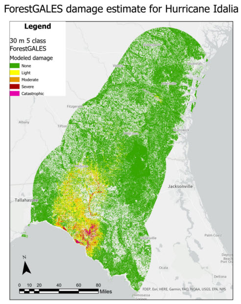 |
| Figure 2. TreeSâ€DIP (ForestGALES) map produced by US Forest Service Geospatial Technology and Applications Center. Credit: Robert Chastain PhD. Report available here. |
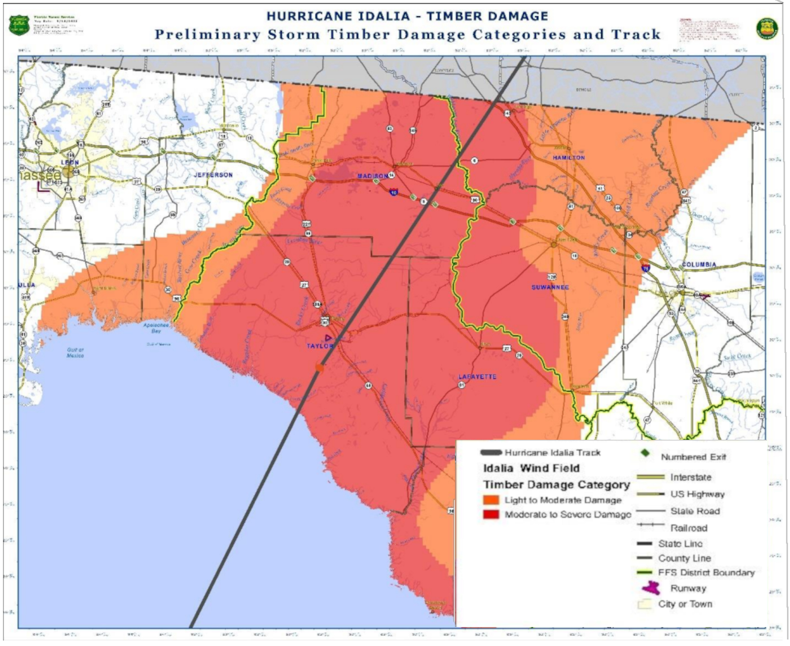 |
| Figure 3. Timber damage assessment from the Florida Department of Agriculture and Consumer Services. Report available here. |
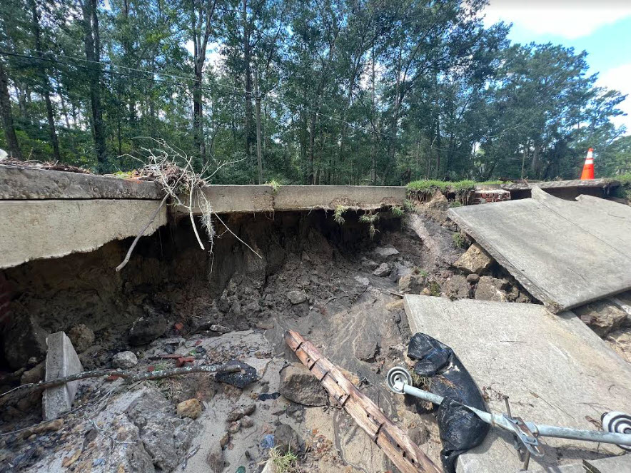
Inland Flooding
Freshwater flooding from Idalia was not as widespread as we've seen during other tropical systems. This was mostly due to the relatively fast forward motion of Idalia. However, Idalia did have wobble after it moved inland so this allowed some areas along the path to see increased rainfall amounts. The greatest impacts from rain were generally felt along and southwest of the I-75 corridor in Madison county and in Lowndes county. It was around these locations that Idalia began to wobble to the left of it's northeast track. This motion allowed the northwestern eyewall, where rainfall rates were highest, to linger over these areas. Around this time, this is when flooding impacts quickly intensified. In Valdosta, there were many reports of water rescues and the saturated soils in the heavy rain allowed trees to fall more easily.
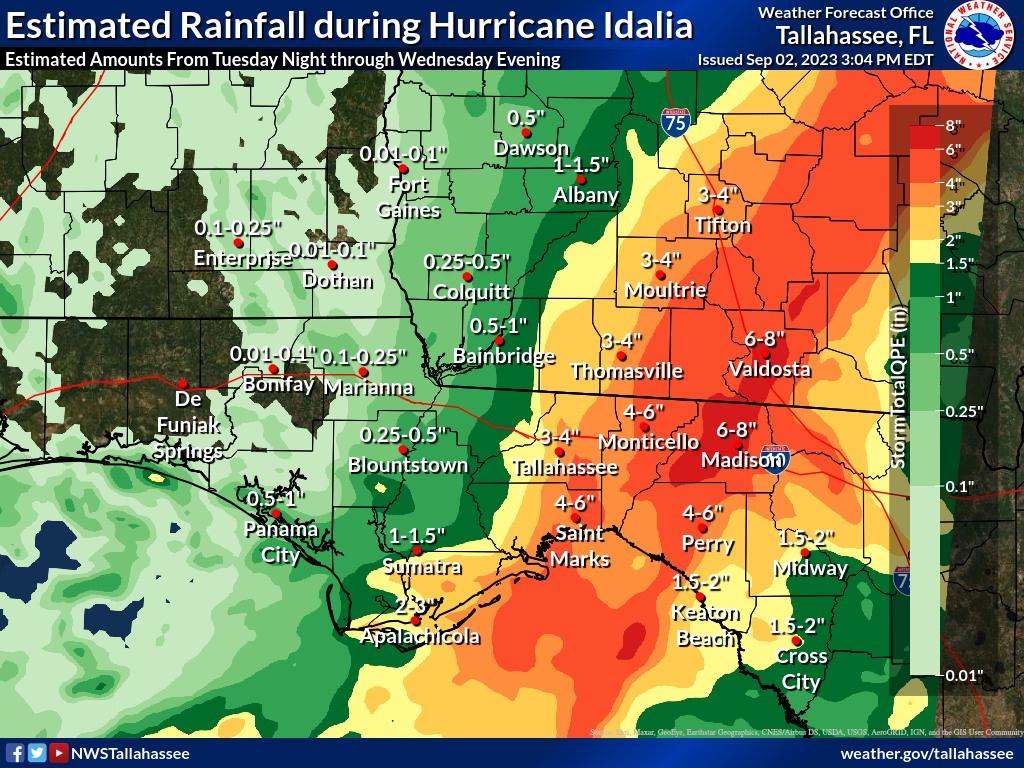 |
| Figure 4. Radar Estimated Rainfall During Hurricane Idalia |
 |
 |
 |
|
A road washed out due to the life-threatening flash flooding from Idalia. Image: Lowndes Emergency Management Erica Thrift, PIO |
Heavy rain allowed trees to fall more easily. In/near Valdosta. Image: Lowndes Emergency Management Erica Thrift, PIO | A high water rescue in a Valdosta apartment complex due to flash flooding from Idalia. Image: Lowndes Emergency Management Erica Thrift, PIO |
Tornadoes
There were no confirmed tornadoes across our forecast area during Idalia, but a few brief spin ups could not have been ruled out.
Fatalities
The was one direct fatality that occurred in Madison county during Hurricane Idalia due to a falling tree
Local (WFO Tallahassee) Preliminary Post Tropical Cyclone Report
Post-Tropical Cyclone Report (NHC)
The Post-Tropical Cyclone Report for Hurricane Idalia will be available here when it is completed by the National Hurricane Center. This report will provide further details regarding the impacts of Hurricane Idalia.

