Overview of Hurricane Sally
Most images on this page may be expanded with a single click and can be returned to original size with a second click.
Please note, data provided on this webpage is also considered preliminary. Finalized data will be available in the final National Hurricane Center Report.
Hurricane Sally made landfall early on the morning of September 16 across Gulf Shores Alabama. While the greatest impacts for Hurricane Sally struck outside our forecast area, in portions of the western Florida Panhandle and southern Alabama, we were not spared from Sally's damage. The greatest impacts to our forecast area came in the form of very heavy rain, flooding on and away from area rivers, and many tornado warnings.
 |
 |
 |
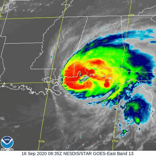
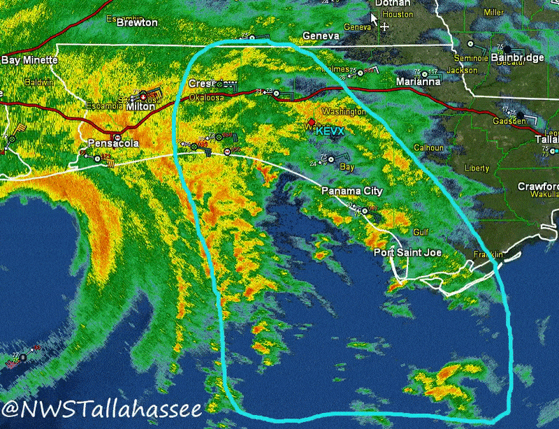
| Satellite Imagery of Hurricane Sally as it was about to make landfall near Gulf Shores, AL. This image was taken around 4:00am CT. | Radar imagery of Hurricane Sally approximately at 3:30am ET on September 16th. This was about 2 hours before landfall. The outer rain bands is what caused the most significant impacts to our region in the form of flooding rain and many tornado warnings. This image (from our Twitter page) was highlighting the increased potential for tornadoes as the bands rotated onshore. | A complete radar loop of Hurricane Sally as it came into US Weather Radar range. This animated image shows the many hours of rain that the region was under. |
Storm History
Information is preliminary and could change with the release of the National Hurricane Center's final report of Hurricane Sally (found here when available).
Hurricane Sally began as a tropical wave off the eastern Bahamas around September 9. Tropical weather outlooks regarding it's potential development indicated a 10% chance for development as it was poorly organized initially. On September 10, additional tropical weather outlooks indicated the potential for devleopment had increased. About twenty-four hours later, on September 11, this wave would eventually became a tropical depression with the 5pm advisory.
Sally would remain disorganized and moderately sheared for much of its trip across the Florida Peninsula into the Gulf of America. As steering currents collapsed, Sally slowed significantly and this set up the stage for a historic flooding event across the Florida Panhandle and into Alabama. Sally would slowly move north the 36 to 48 hours before landfall. As it neared the coast its motion became northeast and eventually made landfall around 445am CDT on September 16th near Gulf Shores, Alabama. Sally's continued slow motion after landfall allowed even more rainfall to fall across Alabama and the Florida Panhandle...leading to record high river levels at many sites which are still extremely high at this time.
 |
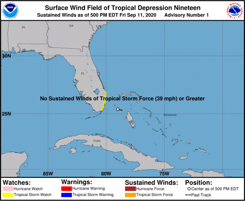 |
| Tropical Weather Outlook, from the National Hurricane Center a little more than 24 hours before it's development into a tropical depression. At this time it was located just off the eastern coast of the Florida Peninsula. | Path of Sally as it first developed into a tropical depression off the eastern Florida Peninsula. Development was slow as it entered the Gulf, but it rapidly strengthened in the 12 hours prior to landfall, nearly becoming a major hurricane (by wind standards). Notice the slow forward speed a day before landfall. This is what increased the magnitude of impacts across the region. |
Local Post Tropical Cyclone Report
National Hurricane Center's Tropical Cyclone Report (This link won't work until report is published).
Reports from neighboring offices will be included here when available: NWS Mobile Sally Webpage
Wind
Information These wind reports are considered preliminary, a final listing of maximum winds will be listed in NHC's final tropical report after the end of the season.
The wind reports below are preliminary and include the highest winds at a specific site through Thursday morning. The time of the observation is approximately when that wind gust occurred.
Public Information Statement
National Weather Service Tallahassee FL
914 AM EDT Thu Sep 17 2020

...HIGHEST WIND REPORTS LAST 48 HOURS...

Location                     Speed     Time/Date       Lat/Lon

...Alabama...

...Coffee County...
Enterprise                   43 MPH    1215 PM 09/16   31.30N/85.90W
Ft Rucker Shell              40 MPH    1021 AM 09/16   31.37N/85.85W
Kinston                      33 MPH    0246 AM 09/16   31.22N/86.17W
Elba                         33 MPH    0715 PM 09/16   31.41N/86.09W

...Dale County...
Ozark Cairns Aaf             45 MPH    1226 PM 09/16   31.28N/85.72W
Molinelli Army Heliport      45 MPH    0935 AM 09/16   31.48N/85.78W
Ft Rucker Hanche             44 MPH    0113 PM 09/16   31.35N/85.65W
Dothan                       39 MPH    1244 PM 09/16   31.32N/85.45W
Fort Rucker                  32 MPH    0516 PM 09/16   31.35N/85.75W

...Houston County...
Rehobeth                     33 MPH    0100 PM 09/16   31.09N/85.46W

...Florida...

...Bay County...
2.1 N Magnolia Beach (WEATHE 54 MPH    1110 AM 09/16   30.19N/85.72W
Tyndall AFB                  54 MPH    0201 PM 09/16   30.07N/85.57W
Panama City                  51 MPH    1019 AM 09/16   30.35N/85.80W
Panama City Beach            49 MPH    0807 AM 09/16   30.23N/85.88W
Southport                    40 MPH    0700 PM 09/16   30.31N/85.61W
Panama City                  37 MPH    0253 PM 09/16   30.20N/85.67W
Panama City                  37 MPH    0640 PM 09/16   30.12N/85.59W
3.3 S Crystal Lake (WEATHERS 35 MPH    1140 AM 09/16   30.39N/85.69W
Panama City                  30 MPH    1116 AM 09/16   30.15N/85.63W

...Dixie County...
Cross City                   30 MPH    0355 PM 09/16   29.63N/83.10W

...Franklin County...
Apalachicola                 54 MPH    0956 AM 09/16   29.73N/85.03W
St. George Island            53 MPH    1214 PM 09/16   29.67N/84.86W
Apalachicola, FL             45 MPH    1030 AM 09/16   29.73N/84.98W

...Gadsden County...
Quincy                       32 MPH    0135 PM 09/16   30.60N/84.55W

...Gulf County...
0.5 NE Port Saint Joe (WEATH 40 MPH    0210 PM 09/16   29.81N/85.29W
0.5 NW Ward Ridge (WEATHERST 36 MPH    1130 PM 09/15   29.79N/85.29W

...Holmes County...
Holmes County Airport        33 MPH    0527 AM 09/16   30.83N/85.60W

...Jackson County...
Marianna                     35 MPH    0935 AM 09/16   30.83N/85.18W
1.5 E Marianna (WEATHERSTEM) 32 MPH    0950 AM 09/16   30.78N/85.22W
Sneads (WEATHERSTEM)         32 MPH    1040 AM 09/16   30.71N/84.92W
1.2 NE Graceville (WEATHERST 30 MPH    0940 AM 09/16   30.97N/85.51W

...Lafayette County...
0.6 E Mayo (WEATHERSTEM)     41 MPH    0410 PM 09/16   30.05N/83.17W

...Leon County...
Tallahassee International Ai 40 MPH    0326 PM 09/16   30.40N/84.35W
Kleman Plaza (WEATHERSTEM)   39 MPH    0340 PM 09/16   30.44N/84.28W
2.0 SW Killearn Estates (WEA 39 MPH    0120 PM 09/16   30.49N/84.25W
Doak Campbell Stadium (WEATH 37 MPH    0120 PM 09/16   30.44N/84.30W
State Capital Complex (WEATH 37 MPH    0120 PM 09/16   30.44N/84.28W
0.5 SW Southwood (WEATHERSTE 34 MPH    0340 PM 09/16   30.38N/84.22W
0.6 SE Forest Meadows Park ( 32 MPH    0130 PM 09/16   30.53N/84.27W
1.6 NW Fallschase (WEATHERST 30 MPH    0120 PM 09/16   30.48N/84.22W
1.1 N Lake Bradford (WEATHER 30 MPH    1230 PM 09/16   30.42N/84.34W

...Madison County...
2.8 N Cherry Lake (WEATHERST 32 MPH    0440 PM 09/16   30.62N/83.41W

...Taylor County...
Keaton Beach                 34 MPH    0600 PM 09/16   29.82N/83.59W

...Wakulla County...
Shell Point (WEATHERSTEM)    54 MPH    0110 PM 09/16   30.06N/84.29W
Shell Point                  43 MPH    1254 PM 09/16   30.06N/84.29W
Panacea                      42 MPH    1246 PM 09/16   29.97N/84.36W
St. Marks                    39 MPH    0146 PM 09/16   30.01N/84.42W
Tully (WEATHERSTEM)          33 MPH    1150 AM 09/16   30.11N/84.38W
St. Marks                    33 MPH    0314 PM 09/16   30.14N/84.14W

...Walton County...
0.7 S Port Washington (WEATH 38 MPH    0610 AM 09/16   30.36N/86.11W
Santa Rosa Beach             38 MPH    0324 PM 09/16   30.35N/86.23W
1.6 E De Funiak Springs (WEA 37 MPH    0740 AM 09/16   30.72N/86.09W
De Funiak Sprngs             36 MPH    0735 AM 09/16   30.73N/86.15W
Mossy Head                   32 MPH    0426 PM 09/16   30.81N/86.30W

...Georgia...

...Ben Hill County...
1.1 NE Fitzgerald Municipal  35 MPH    1110 PM 09/16   31.70N/83.26W

...Colquitt County...
0.6 W Spence Airport (WEATHE 30 MPH    0740 PM 09/16   31.14N/83.71W

...Decatur County...
Bainbridge                   32 MPH    1235 PM 09/16   30.97N/84.63W

...Dougherty County...
Albany                       37 MPH    0323 PM 09/16   31.53N/84.20W

...Early County...
Blakely Early C              31 MPH    0335 PM 09/16   31.40N/84.90W

...Lowndes County...
Valdosta Regiona             33 MPH    0500 PM 09/16   30.78N/83.27W
Moody Afb                    31 MPH    0357 AM 09/17   30.97N/83.20W

...Mitchell County...
Camilla                      34 MPH    0804 PM 09/16   31.21N/84.24W

...Seminole County...
Donalsonville Airport        37 MPH    1235 PM 09/16   31.07N/84.92W

...Tift County...
Tifton                       31 MPH    0135 AM 09/17   31.43N/83.48W

...Florida...

...Maritime Stations...
Panama City Beach, FL        60 MPH    0730 AM 09/16   30.21N/85.88W
2.9 S Eastpoint (WEATHERSTEM 57 MPH    1110 AM 09/16   29.71N/84.89W
St. Andrew Bay               56 MPH    0231 PM 09/15   30.13N/85.72W
17 S Saint George Island     53 MPH    1200 PM 09/16   29.41N/84.86W
Apalachee Bay - Panacea Chan 50 MPH    0104 PM 09/16   30.01N/84.34W

Observations are collected from a variety of sources with varying
equipment and exposures. We thank all volunteer weather observers
for their dedication. Not all data listed are considered official.
Rainfall
Record levels of rainfall fell across much of the tri-state region as a result of Hurricane Sally. The image below highlights region rainfall estimates for rain that fell between Sunday night (September 13) and 2am Thursday morning (September 17th). This graphic is likely to be updated with additional rain that fell on Thursday. Please note, this only estimated via radar, localized amounts are likely higher than indicated in the graphic below.
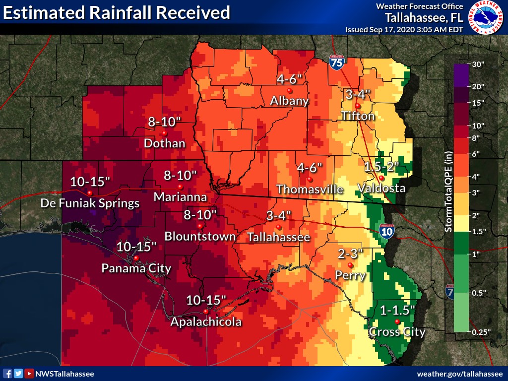 |
| Radar estimated rainfall during the duration of Hurricane Sally. This includes rain that fell between Sunday night and Thursday (Sep 17th) at 2am. Amounts will be updated to include additional rain that fell on Thursday. |
The latest Public Information Statement is below. This product shows observed rainfall at various gauges/locations for the 48 hours preceding Thursday morning. Storm total amounts are likely higher at some locations.
Public Information Statement
National Weather Service Tallahassee FL
912 AM EDT Thu Sep 17 2020

...48 HOUR PRECIPITATION REPORTS...

Location                     Amount    Time/Date       Lat/Lon

...Alabama...

...Coffee County...
Ft Rucker Shell              8.60 in   0858 AM 09/17   31.37N/85.85W
Enterprise                   7.11 in   0855 AM 09/17   31.30N/85.90W
Elba                         5.82 in   0846 AM 09/17   31.41N/86.09W
1.3 E New Brockton           3.18 in   0800 AM 09/16   31.38N/85.90W

...Dale County...
Enterprise 3.8 ESE           10.17 in  0800 AM 09/17   31.30N/85.79W
1.4 S Lowe Army Heliport     8.44 in   0301 AM 09/17   31.34N/85.75W
Ozark Cairns Aaf             5.73 in   0856 AM 09/17   31.28N/85.72W
Ft Rucker Hanche             5.59 in   0858 AM 09/17   31.35N/85.65W
Dothan                       5.29 in   0853 AM 09/17   31.32N/85.45W
Fort Rucker                  4.41 in   0858 AM 09/17   31.35N/85.75W

...Geneva County...
Geneva                       11.25 in  0800 AM 09/17   31.04N/85.87W
Geneva                       3.53 in   0650 AM 09/16   31.06N/85.82W

...Henry County...
Edwin                        6.29 in   0846 AM 09/17   31.65N/85.35W
Headland                     5.31 in   0858 AM 09/17   31.34N/85.36W
Headland                     4.19 in   0845 AM 09/17   31.36N/85.33W

...Houston County...
Rehobeth 2.1 SSW             7.84 in   0800 AM 09/17   31.09N/85.46W
Rehobeth                     6.07 in   0905 AM 09/17   31.09N/85.46W
Dothan                       3.84 in   0859 AM 09/17   31.21N/85.42W

...Florida...

...Bay County...
Southport                    17.56 in  0900 AM 09/17   30.31N/85.61W
Panama City Beach 0.3 SW     14.21 in  0700 AM 09/17   30.21N/85.86W
Lower Grand Lagoon 2.2 NW    10.83 in  0800 AM 09/17   30.16N/85.78W
Panama City                  10.46 in  0903 AM 09/17   30.20N/85.67W
Fountain 3.4 SSE             10.41 in  0755 AM 09/17   30.43N/85.40W
Tyndall AFB                  10.38 in  0856 AM 09/17   30.07N/85.57W
Panama City                  10.26 in  0753 AM 09/17   30.35N/85.80W
Panama City 6.9 ESE          10.18 in  1259 AM 09/17   30.14N/85.57W
Panama City Beach 4.4 ESE    9.99 in   0800 AM 09/16   30.18N/85.79W
Panama City                  7.75 in   0847 AM 09/17   30.15N/85.63W

...Calhoun County...
Chipola River                10.05 in  1145 PM 09/16   30.53N/85.17W

...Franklin County...
Apalachicola Airport         8.90 in   0855 AM 09/17   29.72N/85.03W
Eastpoint 1.4 NW             6.21 in   0700 AM 09/17   29.76N/84.89W
Apalachicola 0.8 WNW         3.93 in   0647 AM 09/15   29.73N/85.01W

...Gadsden County...
Quincy 7.5 SSW               7.76 in   0800 AM 09/17   30.48N/84.62W
Havana 4.2 SW                6.99 in   0700 AM 09/17   30.58N/84.47W
2 ESE Juniper                6.73 in   0855 AM 09/17   30.52N/84.72W
Quincy 6.0 SW                3.21 in   0830 AM 09/16   30.52N/84.66W
Quincy 6.0 SW                3.18 in   0800 AM 09/16   30.53N/84.66W

...Gulf County...
Wewahitchka                  8.30 in   0900 AM 09/16   30.12N/85.20W

...Holmes County...
Holmes County Airport        7.54 in   0858 AM 09/17   30.83N/85.60W

...Jackson County...
Marianna 3.9 E               9.99 in   0800 AM 09/17   30.77N/85.17W
Blue Spring                  9.79 in   0745 AM 09/17   30.79N/85.14W
Marianna 0.8 NNE             9.59 in   0800 AM 09/17   30.78N/85.23W
Woodruff Dam                 9.14 in   0800 AM 09/17   30.71N/84.88W
Marianna                     7.48 in   0845 AM 09/17   30.81N/85.19W
Marianna                     7.44 in   0855 AM 09/17   30.77N/85.17W

...Jefferson County...
Monticello                   4.78 in   0901 AM 09/17   30.50N/84.04W
Monticello 2.9 WSW           4.67 in   0700 AM 09/17   30.53N/83.92W
Monticello 9.8 SW            4.22 in   0700 AM 09/17   30.44N/83.99W
Monticello 1 NNE             4.22 in   0700 AM 09/17   30.56N/83.86W
Monticello 4.3 ENE           3.54 in   0700 AM 09/17   30.56N/83.80W

...Leon County...
Tallahassee 5.5 ENE          5.96 in   0700 AM 09/17   30.48N/84.19W
Tallahassee 5.2 E            5.88 in   0700 AM 09/17   30.44N/84.19W
Tallahassee 5.6 ESE          5.64 in   0700 AM 09/17   30.43N/84.19W
Tallahassee 4.7 ENE          5.59 in   0700 AM 09/17   30.48N/84.21W
Tallahassee                  5.46 in   0846 AM 09/17   30.47N/84.26W
Tallahassee 4.8 ESE          5.28 in   0700 AM 09/17   30.44N/84.20W
Tallahassee                  4.98 in   0855 AM 09/17   30.59N/84.24W
Tallahassee International Ai 4.91 in   0853 AM 09/17   30.40N/84.35W
Tallahassee 4.2 N            4.87 in   0700 AM 09/17   30.52N/84.28W
Bloxham                      4.85 in   0715 AM 09/17   30.36N/84.61W
Tallahassee 5.1 NE           4.80 in   0700 AM 09/17   30.51N/84.22W
Tallahassee 5.7 SE           4.63 in   0700 AM 09/17   30.39N/84.22W
Tallahassee 5.0 SE           4.60 in   0600 AM 09/17   30.41N/84.22W
Tallahassee 3.5 N            4.43 in   0800 AM 09/17   30.51N/84.28W
Tallahassee                  4.31 in   0855 AM 09/17   30.43N/84.28W
Tallahassee 5.6 SE           4.15 in   0800 AM 09/17   30.39N/84.23W
Tallahassee International A/ 4.02 in   0700 AM 09/17   30.40N/84.36W
Tallahassee - PineyZ         3.86 in   0858 AM 09/17   30.44N/84.19W

...Liberty County...
Wilma                        9.59 in   0747 AM 09/17   30.18N/84.94W
Hosford 2.7 SW               9.53 in   0700 AM 09/17   30.35N/84.82W
Sumatra                      8.69 in   0748 AM 09/17   30.02N/84.99W
Telogia 2.5 SE               3.60 in   0700 PM 09/15   30.33N/84.78W

...Wakulla County...
Crawfordville 1.0 S          7.54 in   0500 AM 09/17   30.18N/84.37W
Sanborn                      4.90 in   0719 AM 09/17   30.07N/84.59W
St. Marks                    4.77 in   0746 AM 09/17   30.01N/84.42W
Crawfordville                4.14 in   0859 AM 09/17   30.13N/84.41W
Panacea                      3.82 in   0846 AM 09/17   29.97N/84.36W
St. Marks                    3.08 in   0714 AM 09/17   30.14N/84.14W

...Walton County...
Santa Rosa Beach             17.65 in  0857 AM 09/17   30.35N/86.23W
Miramar Beach 9.5 ESE        14.75 in  0800 AM 09/17   30.35N/86.20W
De Funiak Springs 4.1 NNW    14.15 in  0800 AM 09/17   30.78N/86.14W
De Funiak Springs 2.9 N      13.93 in  0800 AM 09/17   30.76N/86.12W
De Funiak Springs 12.5 NW    12.75 in  0800 AM 09/17   30.84N/86.28W
Inlet Beach 0.7 E            11.94 in  0900 AM 09/16   30.28N/86.00W
3 NNE Freeport               10.94 in  0900 AM 09/17   30.54N/86.12W
Freeport                     8.74 in   0854 AM 09/17   30.49N/86.19W
De Funiak Sprngs             8.61 in   0855 AM 09/17   30.73N/86.15W
Mossy Head                   8.25 in   0856 AM 09/17   30.81N/86.30W

...Washington County...
Vernon 10.6 WSW              10.34 in  0800 AM 09/16   30.57N/85.87W
Sunny Hills 3.3 N            8.02 in   0800 AM 09/16   30.59N/85.58W
Chipley                      7.86 in   0845 AM 09/17   30.74N/85.59W

...Georgia...

...Baker County...
0.7 S Newton                 6.80 in   0515 AM 09/17   31.31N/84.34W
2.3 SE Hoggard Mill          6.63 in   0700 AM 09/17   31.19N/84.45W
Hoggard Mill                 5.74 in   0700 AM 09/17   31.22N/84.47W
3.3 NW Hawkinstown           5.68 in   0800 AM 09/17   31.29N/84.49W
Milford                      5.33 in   0800 AM 09/17   31.38N/84.55W
Elmodel Wma                  4.15 in   0800 AM 09/17   31.35N/84.48W

...Brooks County...
3.4 E Barney                 3.09 in   0815 AM 09/17   31.00N/83.46W

...Calhoun County...
1.2 W Dickey                 4.96 in   0630 AM 09/17   31.55N/84.68W

...Colquitt County...
Moultrie 6.2 SW              4.55 in   0700 AM 09/17   31.12N/83.86W

...Decatur County...
Bainbridge 2.3 ESE           5.25 in   0730 AM 09/17   30.89N/84.54W
Bainbridge                   4.09 in   0855 AM 09/17   30.97N/84.63W
4.3 N Brinson                3.98 in   0545 AM 09/17   31.04N/84.74W
Bainbridge                   3.67 in   0545 AM 09/17   30.91N/84.58W

...Dougherty County...
1.6 NW East Albany           6.83 in   0830 AM 09/17   31.59N/84.14W
Albany 7.3 W                 5.73 in   0830 AM 09/17   31.58N/84.30W
Albany                       5.56 in   0853 AM 09/17   31.53N/84.20W

...Early County...
Cedar Springs                5.34 in   0700 AM 09/17   31.18N/85.04W
2.3 S Columbia               4.56 in   0600 AM 09/17   31.26N/85.11W
Damascus                     4.01 in   0855 AM 09/17   31.30N/84.72W

...Grady County...
Cairo 3.7 ESE                4.57 in   0356 AM 09/17   30.86N/84.15W
Cairo 9.2 NNW                4.32 in   0700 AM 09/17   31.01N/84.25W

...Irwin County...
2.4 SW Irwinville            4.31 in   0645 AM 09/17   31.63N/83.42W

...Lee County...
Starksville                  6.60 in   0715 AM 09/17   31.78N/84.14W
1.9 S Philema                6.44 in   0730 AM 09/17   31.73N/84.02W
2.7 W Jordan Place           4.82 in   0700 AM 09/17   31.76N/84.25W

...Mitchell County...
5.3 S Hoggard Mill           4.85 in   0800 AM 09/17   31.14N/84.48W
2.7 S Camilla                4.66 in   0700 AM 09/17   31.19N/84.20W
Camilla 2.8 SE               4.66 in   0700 AM 09/17   31.20N/84.17W
Camilla 1.5 SSW              4.34 in   0830 AM 09/17   31.21N/84.22W
Pelham 10.8 W                4.28 in   0700 AM 09/17   31.12N/84.33W
Camilla                      3.97 in   0804 AM 09/17   31.21N/84.24W
Camilla                      3.52 in   0900 AM 09/17   31.23N/84.20W

...Quitman County...
1.5 SE Crossroads            4.91 in   0700 AM 09/17   31.82N/84.97W

...Seminole County...
Donalsonville Airport        4.40 in   0855 AM 09/17   31.07N/84.92W

...Terrell County...
Sasser 0.2 WSW               3.95 in   0700 AM 09/17   31.72N/84.35W

...Thomas County...
3.7 SW Dawesville            6.54 in   0800 AM 09/17   30.88N/84.05W
Thomasville 2.8 E            4.61 in   0800 AM 09/17   30.84N/83.93W
2.2 S Chastain               3.99 in   0800 AM 09/17   31.00N/83.94W
Thomasville                  3.51 in   0855 AM 09/17   30.83N/83.98W

...Tift County...
1.4 NE Hillsdale             3.47 in   0730 AM 09/17   31.48N/83.58W
Tifton 2.0 ENE               3.41 in   0800 AM 09/17   31.48N/83.48W
Tifton 1.4 ENE               3.23 in   0700 AM 09/17   31.47N/83.49W

...Turner County...
Ashburn                      3.64 in   0903 AM 09/17   31.71N/83.65W

...Worth County...
Crisp Co Power Dam           5.36 in   0800 AM 09/17   31.85N/83.94W

Observations are collected from a variety of sources with varying
equipment and exposures. We thank all volunteer weather observers
for their dedication. Not all data listed are considered official.
Storm Surge / Beach Erosion / River Flooding
Storm surge impacts were mostly limited to the Walton County coastline, but minor coastal flooding affected nearly our entire coastline. In addition high surf brought beach erosion to many local beaches. In addition to limited storm surge, the biggest impacts from Sally were near-record to record river flooding.
 |
Media use of NWS Web News Stories is encouraged! Please acknowledge the NWS as the source of any news information accessed from this site. |
|

