| A Review of Local Weather in 2010 |
Weather headlines in 2010 focused on the many temperature extremes that occurred during both the winter and summer months, and the distinct lack of significant severe weather throughout much of the year, including hurricane season. La Niña developed in time to have a a huge impact on the hurricane season activity across both the Atlantic and Eastern Pacific basins. The Eastern Pacific had the fewest named storms and fewest hurricanes on record since the satellite era began in the mid 1960's. Meanwhile, the season across the Atlantic Basin was a "Gentle Giant," according to NOAA. As can be seen in Figure 1 (below), a total of 19 named storms formed – tied with 1887 and 1995 for third highest on record. Of those, 12 became hurricanes – tied with 1969 for second highest on record. Five of those reached major hurricane status of Category 3 or higher. Despite all of this activity, impact on the United States was minimal. Only one tropical cyclone made landfall in the U.S., Tropical Storm Bonnie in late July in South Florida. South Texas was impacted by a couple of systems as well, and that is it. 2010 was the first year since 1999 that there were absolutely no tropical storm or hurricane watches or warnings issued for the NWS Tallahassee county warning area.
Details on the significant severe weather and tropical cyclone events that occurred in 2010 (and previous years) can be found on our Significant Events Web Page.
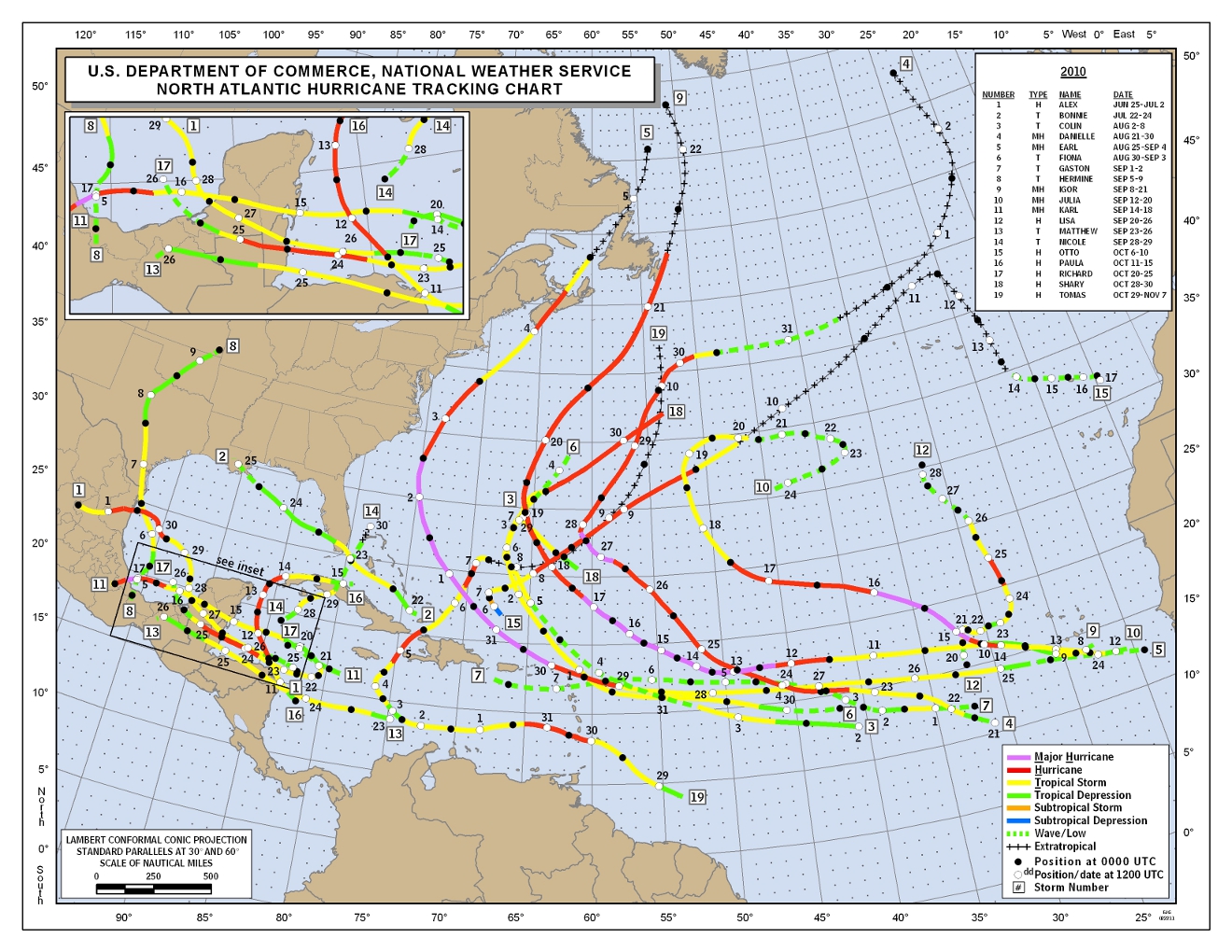
Figure 1. Best track final storm tracks for the 2010 Atlantic Hurricane Season.
As can be seen in Figure 2 (below), there were several periods of very cold weather during the first 10 weeks of the year as much of the eastern U.S. was under the influence of the negative phase of the North Atlantic Oscillation. The result was an exceptionally snowy winter for many of the large cities of the Northeast and Mid-Atlantic regions. There was even a snow storm as far south as our forecast area. There were 14 consecutive days with minimum temperatures below freezing from January 2nd-15th. This broke the old record of 13 consecutive days set in the winter of 1966. The coldest temperature of the year occurred on January 11th, when the mercury dipped to 14 degrees. There was a significant mild spell in late January, but then the big chill returned for much of February and on into early March. February 2010 was the 4th coldest on record. The 2009-10 winter season (Dec.-Feb.) came in as the 6th coldest on record overall. The 3-month period from January through March was the 2nd coldest such three-month period on record in Tallahassee, behind only 1978. A rare Gulf Coast snow storm brought significant snow accumulations to northwestern portions of the forecast area on February 12th with measurable snow occurring as far southeast as Thomas County GA and Gadsden County FL. Maximum snowfall totals of 4 to 6 inches occurred along the northern fringe of the forecast area and on up into central portions of AL and GA. A trace of snowfall was officially observed at the TLH airport on the evening of February 11th. Additional details on this historic snow storm can be found on our event web page.
The spring month of April had near normal temperatures. An extended period of above normal temperatures then commenced in May and continued through September. Each of those five months finished among the top six all-time hottest: May was tied with 1999 for 5th hottest; June tied 1952 for 2nd hottest; July was the 3rd hottest; August tied 1999 for 2nd hottest; and September tied 1954 for 6th hottest on record. This persistent heat made the meteorological summer of June through August tied with 1998 for the hottest on record. While 1998 had more days (16) with the mercury reaching 100 degrees or better, 2010 had very persistent levels on high humidity to go along with the heat with minimum temperatures remaining consistently several degrees above normal throughout the summer, and particularly from mid July through August. There were five days during the summer when 100-degree temperatures were recorded in Tallahassee, with the hottest temperature of the year of 103 degrees coming on July 30th. The mean temperature on that day was 91 degrees. Both numbers tied several other dates in history as the all-time high for this observing station.
The autumn months of October and November saw much more volatility in temperatures, which is typical of the season, with both averaging slightly below normal temperature-wise. Then the bottom fell out in December. All but eight days during the month saw freezing temperatures and there were nine hard freezes. The average temperature for the month was nearly ten degrees colder than normal, making December 2010 the coldest on record. The second snowfall of the year occurred the day after Christmas, when much of the region saw snow flurries from the pre-dawn through midday hours. A trace of snowfall was officially observed at the TLH airport on December 26th.
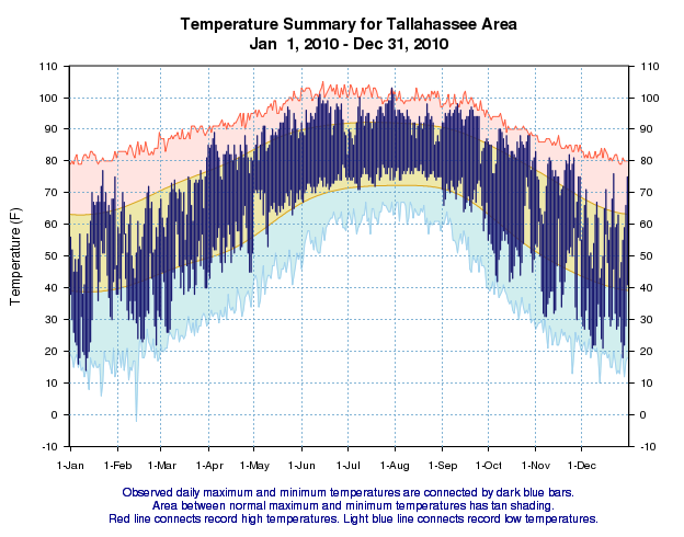
Figure 2. Temperatures versus normal and records in Tallahassee during the year 2010.
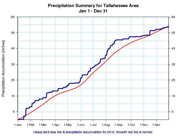
Figure 3. Rainfall versus normal in Tallahassee during the year 2010.
As can be seen in Figure 3 (above), rainfall for the calendar year came in at 58.54 inches, just under five inches below normal. While the year began on a dry note during that prolonged cold spell, heavy rains occurred on several occasions from mid January through early March. January was the 10th wettest on record. The frequent winter rains produced a comfortable surplus of rainfall for the area that even the dryness of April could not fully erase. We did dip briefly below normal in late May before heavy rains during the last few days in the month and first few days of June returned us to a surplus condition. Rainfall was above normal for June and near normal in July. August was a very wet month and we had healthy surpluses to show for it. Then, as typically happens as we transition from summer to autumn, rainfall dropped off dramatically during the last week of August and through much of September. By early October, we were running a rainfall deficit. The dry conditions lasted through the month and through most of November as well. Only one day saw significant rainfall in November. The deficit slowly built through the month of December. Other areas north of the Florida border had a drier year than Tallahassee and will end the year in severe drought (Figure 4, below). These conditions are expected to worsen through the remaining winter months as the area remains under the drying influence of La Niña.
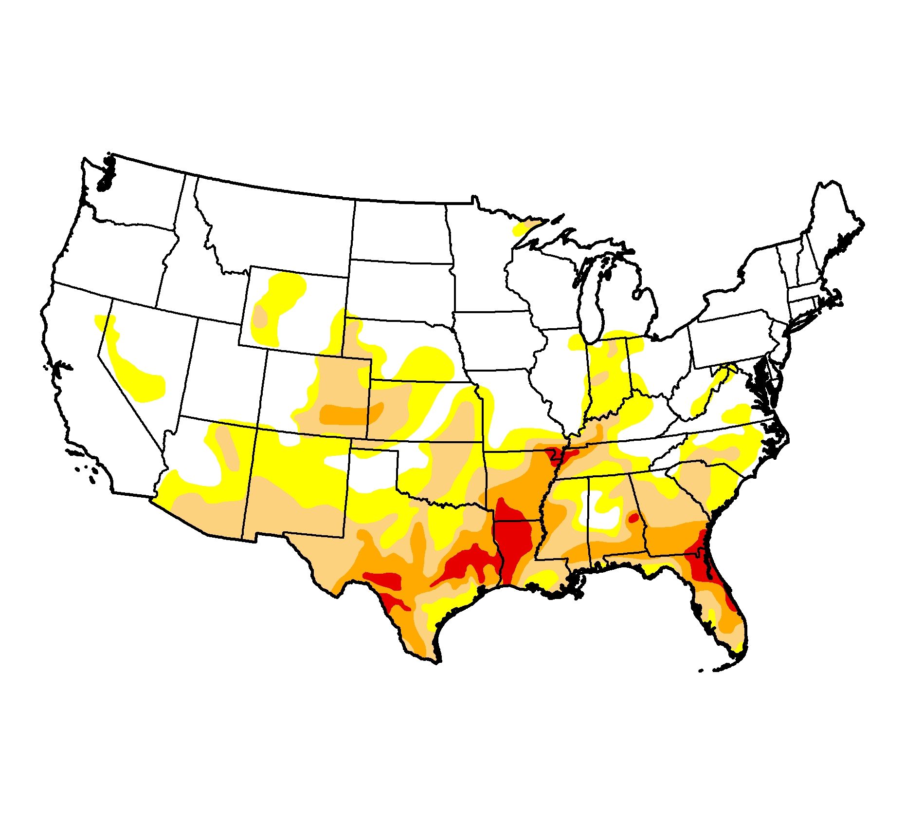
Figure 4. U.S. Drought Monitor from December 28, 2010 depicting severe (medium orange) to extreme (dark orange) drought conditions across much of the Gulf Coast region.
Previous Years
Reviews of local weather in 2009, 2008, 2007, 2006, 2005, 2004, 2003, 2002, 2001 and 2000 are also available.
National Weather in 2010
NCDC provides a review of annual weather across the nation in 2010 including significant events.

