| March 15, 2001, Tornado Outbreak |
Four tornadoes touched down in the NWS Tallahassee County Warning Area during the early morning hours of Thursday, March 15, 2001. The first tornado touched down at 3:30 am CST near the Panhandle town of Wausau, FL, in Washington County and was on the ground for 18 minutes. This tornado was rated an F2 on the Fujita scale as it crossed the eastern part of the county, weakening to F1 strength as it crossed into the Round Lake area of southwestern Jackson County. Figure 1 shows reflectivity and storm relative velocity (SRM) images from the KTLH Doppler radar five minutes before touchdown. Figure 2 is a time-height cross section of gate-to-gate velocities associated with the Wausau tornado, showing the intense vertical structure through the tornadic thunderstorm. Unfortunately, there was one fatality associated with this storm and 21 others were injured. Dozens of homes were either damaged or destroyed.
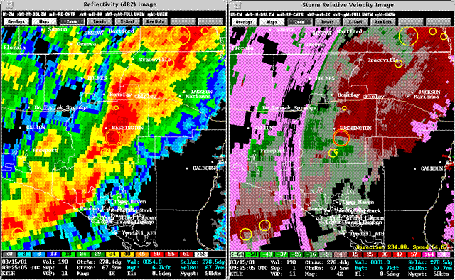
Figure 1. KTLH Reflectivity and Storm Relative Velocity at 0925 UTC.
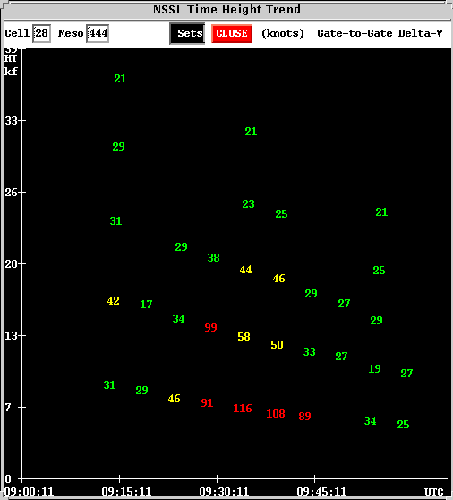
Figure 2. Time-height cross section of velocity associated with Wausau tornado.
Less than two hours later, another F2 tornado touched down near the Decatur-Grady County line in Southwest Georgia. The twister developed around 6:10 am EST near Feuell Rd., 3 miles south of Climax, GA, and was on the ground for about seven minutes, passing near Whigham, GA, at 6:15 am. Figure 3 shows the reflectivity and SRM around the time of touchdown. This storm injured twelve people and several homes were damaged or destroyed.
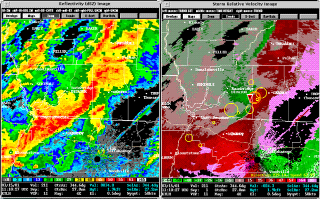
Figure 3. KTLH Reflectivity and Storm Relative Velocity at time of touchdown (1110 UTC).
A few minutes later, another tornado touched down at 5:30 am CST in the Eastern Florida Panhandle, north of Wewahitchka between Chipola Park and Kinard, in Calhoun County. The tornado was just F0 strength as it touched down, damaging some sheds and a couple of barns. The tornado was only the ground for about five minutes and briefly strengthened to F2, damaging several trees as it crossed SR 73. The twister then caused F1 damage to some unoccupied structures on SW Clayton Shiver Rd.
Finally, a fourth tornado touched down northeast of Pavo, GA, along the Thomas-Brooks County line at 8:05 am EST. This tornado was rated F1 and was on the ground for about 15 minutes. The reflectivity and SRM near the time of touchdown are depicted in Figure 4. Fortunately, no one was injured in this storm and damage was minimal.
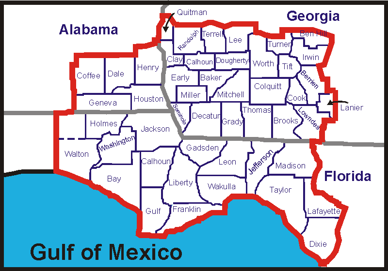
The damage paths of the four tornadoes are found in Figure 5. A loop of radar refelctivity through the duration of the event is available in Figure 6.

Figure 4. KTLH Reflectivity and Storm Relative Velocity at time of touchdown (1215 UTC).

Figure 5. Damage paths of tornadoes.
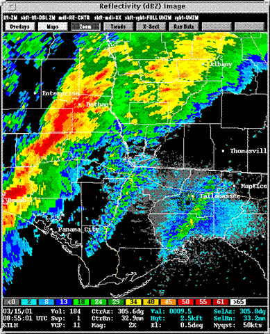
Figure 6. Loop of Reflectivity.
Local Storm Report
NWUS52 KTAE 162302
LSRTAE

PRELIMINARY LOCAL STORM REPORT...CORRECTED
NATIONAL WEATHER SERVICE TALLAHASSEE FL
602 PM EST FRI MAR 16 2000

CORRECTED TO CHANGE TIMES

TIME(EST)  .....CITY LOCATION..... STATE  ...EVENT/REMARKS...
           ....COUNTY LOCATION

0438 AM    ORANGE HILL & WASSAU      FL   TORNADO. 10-20 MOBILE HOMES
03/15/01   WASHINGTON                     DESTROYED. 2 OR 3 FRAME
                                          HOMES DAMAGED
                                          *** 1 DEATH ***
                                          *** 9 INJ ***
                                          8 MINOR & 1 SERIOUS (LIFEFLIGHT)
                                          REPORTED BY EMERGENCY OFFICIAL.

0440 AM    4-5 MI SOUTH OF ALFORD    FL   TORNADO. 15 HOMES (MOBILE AND BRICK)
03/15/01   IN ROUND LAKE AREA             DAMAGED.  ONE HOME DESTROYED.
           JACKSON                        NO INJURIES.
                                          REPORTED BY EMERGENCY OFFICIAL.

0615 AM    WHIGHAM                   GA   TORNADO.
03/15/01   GRADY                          *** 9 INJ ***
                                          10 HOMES DAMAGED ON PINEY
                                          GROVE ROAD 4 MI SOUTHWEST OF WHIGHAM.
                                          2 HOMES DESTROYED. ADDITIONAL DAMAGE
                                          OCCURED 2 1/2 MILES SOUTHWEST OF
                                          WHIGHAM AT ATTAPULGUS AND CLEON ROAD
                                          INTERSECTION WHERE 5-6 HOMES WERE
                                          DAMAGED. APPROXIMATELY 10 ADDITIONAL
                                          NON-HOUSE STRUCTURES SUCH AS BARNS
                                          ETC. WERE DAMAGED.
                                          REPORTED BY EMERGENCY OFFICIAL
                                          TO RECAP...
                                          BASED ON SPOTTER REPORT OF DAMAGE
                                          ALONG TORNADO PATH...
                                          8 TRAILERS DESTROYED.
                                          2 WOOD AND ONE BRICK HOMES DAMAGED.
                                          2 WOOD HOUSE DESTROYED.

0610 AM    FEUELL RD 3 MI S OF CLIMAX     *** 3 INJ ***
03/15/01   DECATUR                        ONE CRITICAL INJ AND TWO STABLE INJ.
                                          SOME HOMES MINOR DAMAGE TO SHINGLES
                                          AND WINDOWS AFFECTING APPROXIMATELY
                                          5 HOMES.  SOME TREES DOWN.
                                          ADDITIONALLY...
                                          ONE WOOD HOUSE DESTROYED.
                                          TWO MOBILE HOMES DESTROYED.
                                          EIGHT OTHER HOMES DAMAGED INCLUDING
                                          TWO BRICK...COUPLE OF MOBILE HOMES
                                          AND ABOUT FOUR WOOD HOMES.
                                          REPORTED BY EMERGENCY OFFICIAL.

0805 AM    PAVO                      GA   TORNADO TRAVELED NORTHEAST NEAR
03/15/01   THOMAS                         HIGHWAY 122 NEAR FIVE FORKS
                                          9.6 MILES NORTHEAST OF PAVO.
                                          NO DAMAGE REPORTED AT THIS TIME.
                                          REPORTED BY EMERGENCY OFFICIAL.


JL/MCT

