| 10 Year Anniversary of the Enterprise, AL Tornado |
March 1, 2017 marks the 10 year anniversary of the Enterprise, AL tornado. This tornado caused nine fatalities and is the only EF-4/F4 or stronger tornado on record across the NWS Tallahassee County Warning Area. A summary from the Enterprise tornado event can be found below.
| Tornado Outbreak of March 1-2, 2007 |
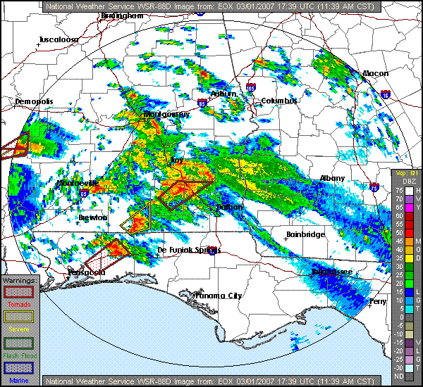
Beginning midday Thursday, March 1, and continuing into the early morning hours of Friday, March 2, 2007, the NWS Weather Forecast Office in Tallahassee issued 57 warnings. These included 35 tornado, 19 severe thunderstorm, and 4 special marine warnings. During this time, warnings were issued for two deadly tornadoes, which caused the loss of 15 lives, nine in Enterprise, AL, and six just north of Newton, GA. Figure 1 shows the extent of the severe weather during the event. Preliminary tornado tracks are indicated with charcoal gray ovals. Straight-line wind damage reports occurred within the white rectangles. Following the image is a preliminary assessment of the two deadly tornadoes, and other severe weather that occurred during the event.
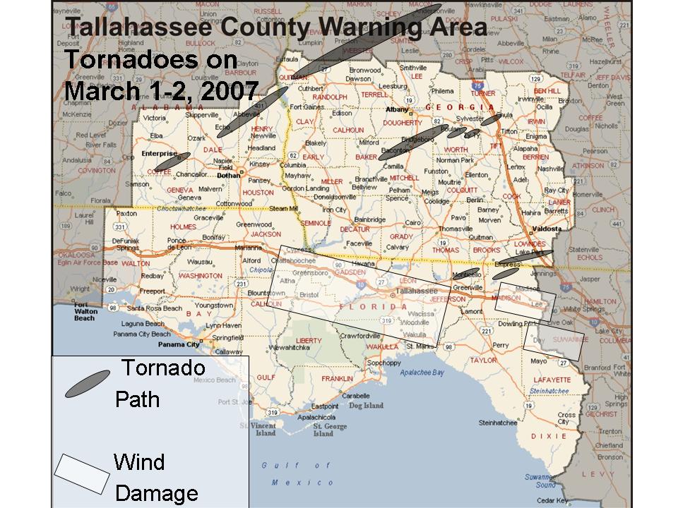
Figure 1. Extent of the severe weather outbreak of March 1-2, 2007. Tornado paths are indicated in charcoal gray. Areas of straight-line wind damage are indicated by white rectangles. Click on the image for a larger view.
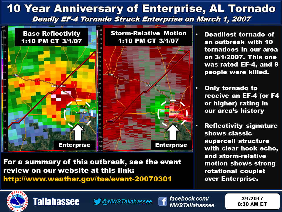
The deadliest tornado was also the first. A tornado warning was issued by this office at 1847 UTC (12:47 PM CST) for Coffee County including the City of Enterprise, AL. An NWS Storm Survey Team determined that a tornado rated EF4 on the new enhanced Fujita Scale touched down in Enterprise, AL, 18 minutes later at around 1905 UTC (1:05 PM CST). The tornado was first observed on the ground at the Enterprise Municipal Airport. About five minutes later, after briefly lifting, it slammed into the Enterprise High School killing eight students and injuring at least 50. The fatalities occurred when a concrete wall collapsed onto a group of students huddled in the hallway in a crouched position. The football stadium was severely damaged. Figure 2 shows the track and areas damaged by the tornado as it crossed Enterprise. Figure 3 shows some of the damage to the high school, courtesy of WTVY-4.
Downtown Enterprise, where an additional fatality occurred, was also hit hard with damage to homes on several streets and many roads blocked by downed power lines. The tornado path was approximately 200 yards wide and 10 miles long. Figures 4 and 5 show the base reflectivity and storm-relative velocity from the Fort Rucker Doppler radar (KEOX) at the time the twister reached the high school. In the reflectivity image, note the blob of high reflectivity just east of the "hook," likely caused by debris.
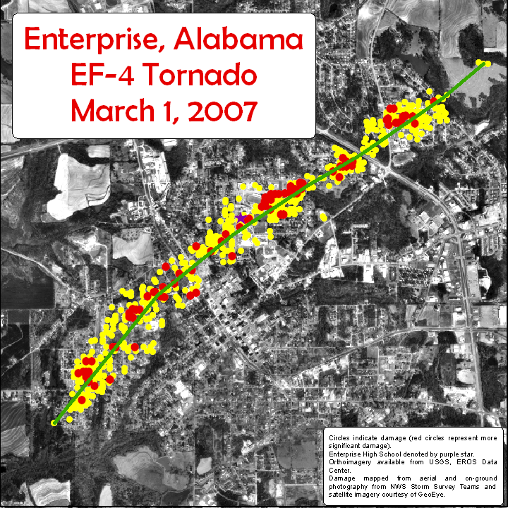
Figure 2. Track and areas damaged by the EF-4 tornado that struck Enterprise, AL, on Thursday, March 1, 2007. Circles indicate damage with red circles representing significant damage. Enterprise High School is denoted by the purple star. Orthoimagery available from USGS, EROS data center. Damage mapped from aerial and on-ground photography from NWS Storm Survey teams and satellite imagery courtesy of GeoEye. Click on the image for a larger view.
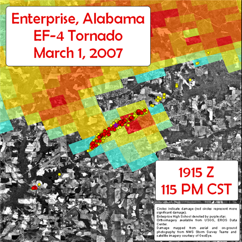
Figure 2a. Areas damaged by the EF-4 tornado that struck Enterprise, AL, on Thursday, March 1, 2007. The base reflectivity image from the Ft. Rucker, AL, Doppler Radar (KEOX) for 1915 UTC is overlaid. Circles indicate damage with red circles representing significant damage. Enterprise High School is denoted by the purple star. Orthoimagery available from USGS, EROS data center. Damage mapped from aerial and on-ground photography from NWS Storm Survey teams and satellite imagery courtesy of GeoEye. Click on the image for a larger view.
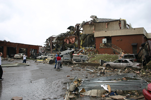
Figure 3. Damage sustained by the Enterprise High School from the deadly tornado that struck on Thursday, March 1, 2007.
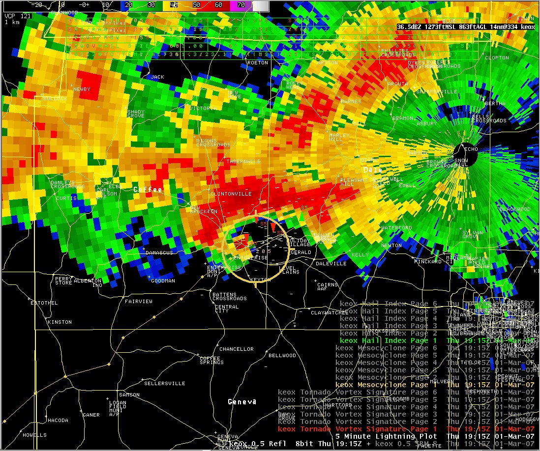
Figure 4. The base reflectivity image from the Ft. Rucker, AL, Doppler Radar (KEOX) for 1915 UTC 1 March 2007.

Figure 5. The base storm-relative velocity image from the Ft. Rucker, AL, Doppler Radar (KEOX) for 1915 UTC 1 March 2007.
The supercell that produced the Enterprise tornado sped northeast across Dale Co., dropping golf ball size hail in Ozark and quarter size hail in Newton, AL. A tornado briefly dropped back to the ground in Level Plains, AL, near CR 1 at around 1925 UTC (1:25 PM CST). This same parent supercell spawned another tornado in northeastern Dale County at Echo around 1950 UTC (1:50 PM CST). A total of 15 homes were damaged or destroyed, and four people sustained minor injuries in Echo. The tornado then moved into Henry Co, AL, causing damage around 2005 UTC (2:05 PM CST). Several homes were damaged west and southwest of Abbeville. A tractor trailer was overturned northwest of Abbeville. The tornadic supercell continued on into Georgia, causing more damage in Clay County near and north of Fort Gaines around 2030 UTC (3:30 PM EST) before moving north of the our county warning area of responsibility. Figure 6 shows the approximate damage path of the tornado as it crossed Dale and Henry Counties. Click here for a loop of radar imagery and warning area polygons as this supercell crossed southeast Alabama. At about the time this storm exited the area, a series of four supercells can be seen lined up from south central Alabama east to west central Georgia as shown in Figure 7 below.
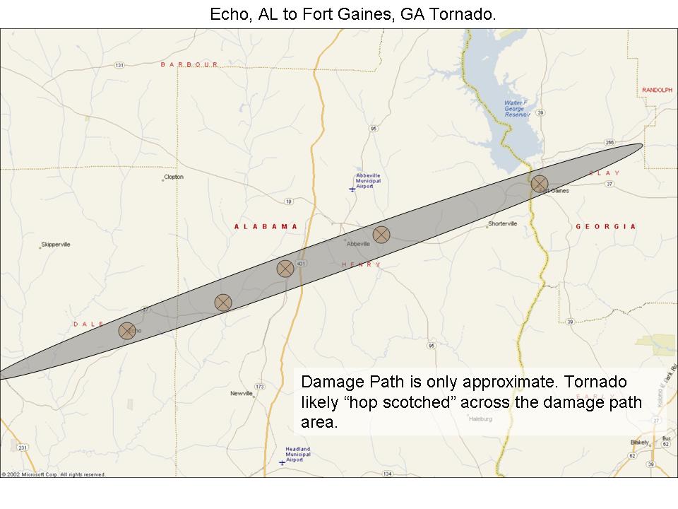
Figure 6. Damage path of the tornado that moved from Echo, AL, northeast across Henry County into Clay County, GA, on Thursday, March 1, 2007. Click on the image for a larger view.
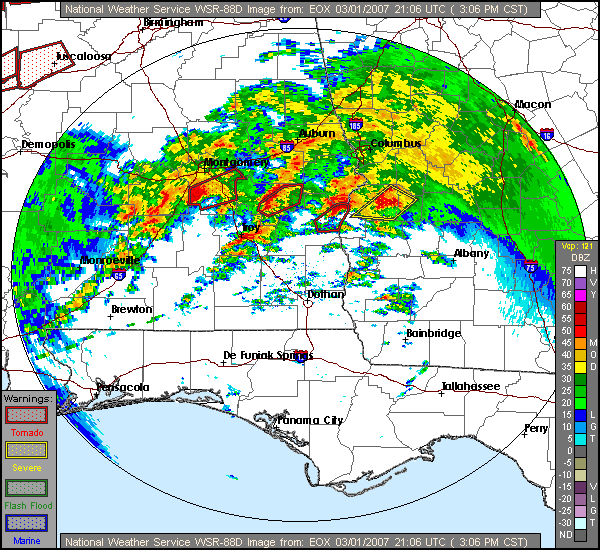
Figure 7. The base reflectivity image from the Ft. Rucker, AL, Doppler Radar (KEOX) for 2106 UTC 1 March 2007. Warning polygons are overlaid.
After nearly a 5-hour lull in the action, severe weather developed anew, wreaking havoc across southwest and south central Georgia overnight. A supercell moved into storm-ravaged Coffee County, AL, where Enterprise is located, at around 0015 UTC 2 March (6:15 PM CST). This storm moved east northeast across the county and northern portions of Dale and Henry Counties over the next hour. Fortunately, no severe weather was reported in these areas. However, rotation was noted in the storm as it crossed Henry Co. and Doppler radar indicated a tornado as it moved into Clay, Quitman and Randolph Counties in GA. Damage occurred in these counties between around 0125 UTC and 0140 UTC (8:25 and 8:40 PM EST). Between 0245 UTC and 0350 UTC (8:45-9:50 PM CST), thunderstorm wind damage was reported in Walton County, FL, Henry County, AL, and Clay County, GA. The public reported an unconfirmed tornado near Marianna, FL in Jackson County during this time.
The second deadly tornado of the outbreak touched down in northern Baker Co., GA, moved east across northern Mitchell Co., skirted extreme southeast Dougherty Co., and crossed into Worth Co. A NWS storm survey revealed that two other tornadoes briefly touched down in Worth Co., while yet another tornado tracked across northwest Tift Co. into southeast Turner Co. The first of these four tornadoes killed six people in mobile homes in Baker County, while 13 structures were damaged in Baconton and Pleasant Grove in Mitchell County, although no injuries or fatalities were reported in these areas. All of these tornadoes were rated EF2. Figure 8 shows the approximate damage paths of the tornadoes as they moved across the area. Figure 9 shows the supercell as it was crossing from Baker into Mitchell County at 0451 UTC (1151 PM EST). Figure 10 shows a debris field where a trailer park once stood in Baker Co. This is where the fatalities occurred.
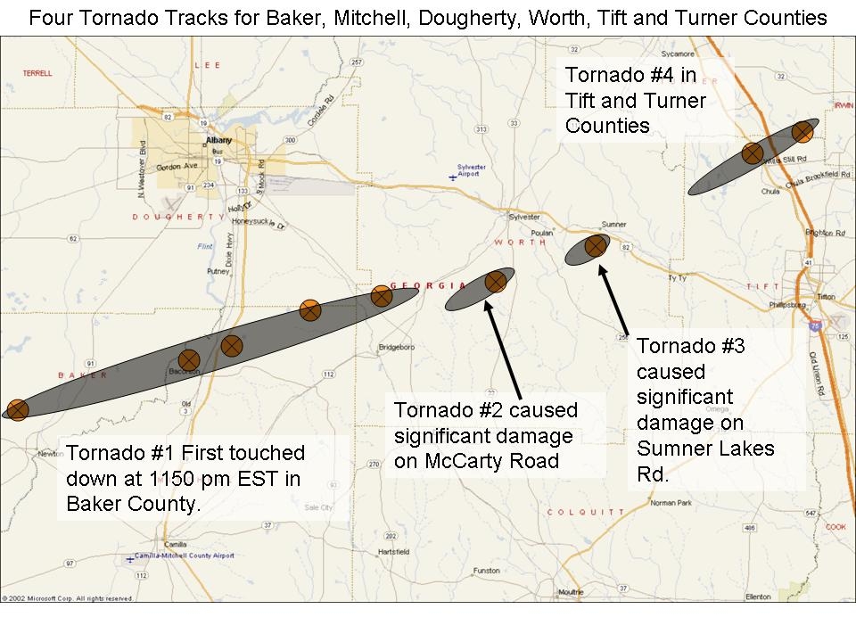
Figure 8. Damage path of the tornadoes that moved across Baker, Mitchell, Dougherty, Worth, Tift, and Turner Counties in GA, on Thursday, March 1, 2007. Click on the image for a larger view.
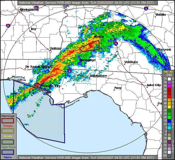
Figure 9. The base reflectivity image from the Tallahassee, FL, Doppler Radar (KTLH) for 0451 UTC (1151 PM EST) 2 March 2007. Warning polygons are overlaid.
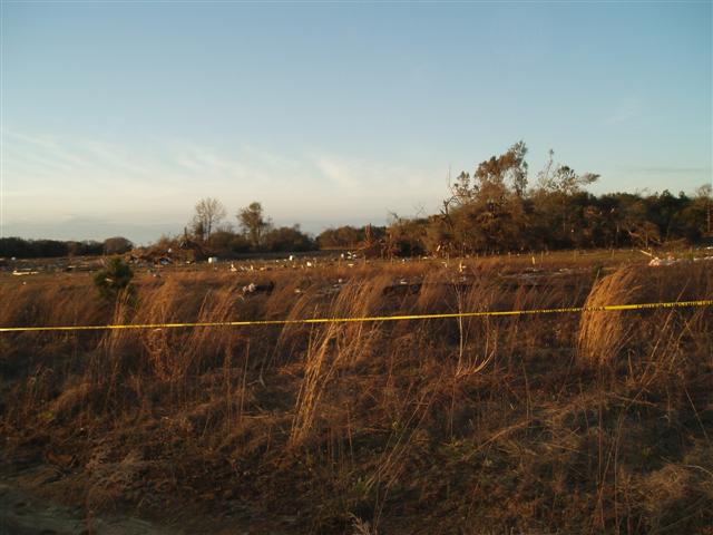
Figure 10. Debris field after a tornado completely destroyed a trailer park north of Newton, GA, late in the evening on Thursday, March 1, 2007.
The final round of severe weather commenced just before midnight EST. The radar operator noted a 48-mph wind gust at the Marianna, FL, ASOS at 0454 UTC (10:54 PM CST). The radar indicated a bowing line segment with a MARC (Mid Altitude Radial Convergence) signature. Severe thunderstorm warnings were issued for Jackson and Calhoun Counties in the Florida Panhandle and eventually extended eastward across nearly every county in the Florida Big Bend. Numerous trees were downed county-wide over Calhoun and Liberty Counties around 0530 UTC (12:30 AM EST). Between 0600 UTC and 0710 UTC (1:00-2:10 AM EST), trees were reported down near Havana in Gadsden County, over Northern Leon County near Lake Jackson, north of Crawfordville in Wakulla County, and east of Monticello in Jefferson County. Trees were also felled over southern Brooks County in south central GA. Figure 11 shows the squall line as it crossed Leon County. A book-end vortex spun up on the northern end of the bowing segment and produced a brief tornado touch down near Cherry Lake, FL in Madison Co. at around 0730 UTC (2:30 AM EST). A brief tornado touch down was also reported in the Lake Park section of Lowndes Co., GA, about a half hour later. Finally, numerous trees and power lines were downed near Buckville in Lafayette Co., FL, at around 0855 UTC (3:55 AM EST). The event duration, from the time the first significant weather alert was issued (0820 UTC 1 March; 3:20 AM EST) in Walton County, FL, to the time the last damage occurred in Lafayette County, was over 24 hours.

Figure 11. The base reflectivity image from the Tallahassee, FL, Doppler Radar (KTLH) for 0632 UTC 2 March 2007. Warning polygons are overlaid.
More information on these events is available through Storm Data for the AL and GA tornadoes confirmed on this day.
Additional details can be found in the SPC report archive for this event.

