| Severe Weather and Flooding of Late March and Early April 2009 |
March 2009 certainly did not go out like a lamb for Alabama, Georgia, and North Florida. A series of weather systems began affecting the region during the last week of March, all similar in nature with similar storm tracks, severe weather, and heavy rain. The week of Sunday, March 29th through Saturday, April 4th, was particularly wet. The record breaking rainfall has overshadowed any severe weather. The 10-day radar-derived rainfall is displayed in Figure 1. A swath in excess of 12 inches (light purple) extends from the extreme western Florida Panhandle eastward into Southeast Georgia with maximum rainfall estimates in excess of 16 inches (white). Record or near record river levels have been observed or are forecast across South Central Georgia and the Florida Big Bend and Panhandle. Flooding on the Withlacoochee and Suwannee Rivers has already forced the closure of U.S. Highways 84 and 90, and if predicted crests are realized, Interstate 10 could be next. Figure 2 shows that the Withlacoochee River at Pinetta, GA, exceeded its 1948 flood of record by 2.66 ft during this event.
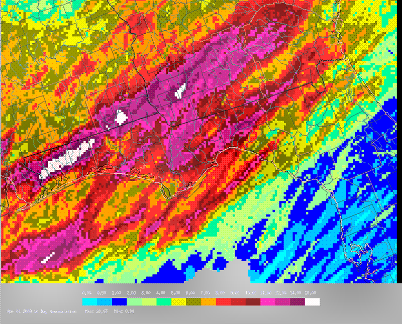
Figure 1. Ten-day summation of radar-derived rainfall ending 2000 UTC (4 pm EDT) April 4, 2009.
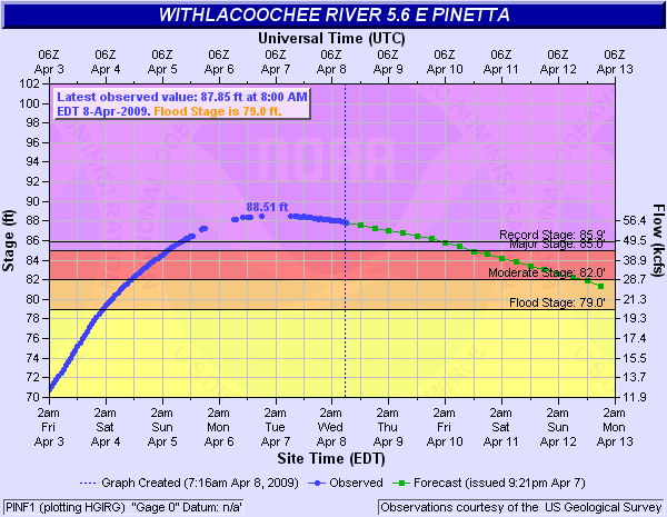
Figure 2. Plot showing stages on the Withlacoochee River at Pinatta, GA, from April 3-8, 2009, with forecast stages out to April 13.
Besides the rainfall and record breaking flooding, several significant weather makers have caught our eye during this period. A summary follows.
1. The FSU Golf Course/Innovation Park/Alumni Village wind storm on April 2nd.
Figures 3 & 4 are image loops of reflectivity and radial velocity for the period 2144 UTC (5:44 pm EDT) to 2359 UTC (7:59 pm EDT). As the squall line/gust front boundary approaches the radar in this loop, the green color-coded radial velocity (Fig. 4) is observed as high as 56 kt (64 mph). At 2340 UTC (6:40 pm EDT), the boundary passes the radar and simultaneously hits the FSU Golf Course/Innovation Park area producing significant straight-line wind damage, estimated to be around 70+ mph. As the boundary passes the radar, outbound radial velocities are color-coded red. The radar reported radial velocities are as high as 62 kt (71 mph) as the boundary races eastward across southern Leon County. Incidentally, the boundary was moving at 50 kt (58 mph).
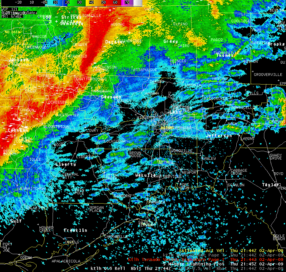
Figure 3. Radar loop of Tallahassee WSR-88D Reflectivity beginning 2 April 2009, 2144 UTC (5:44 pm EDT) and ending at 2359 UTC (7:59 pm EDT). Cloud-to-ground lightning indicated by white + and - signs.
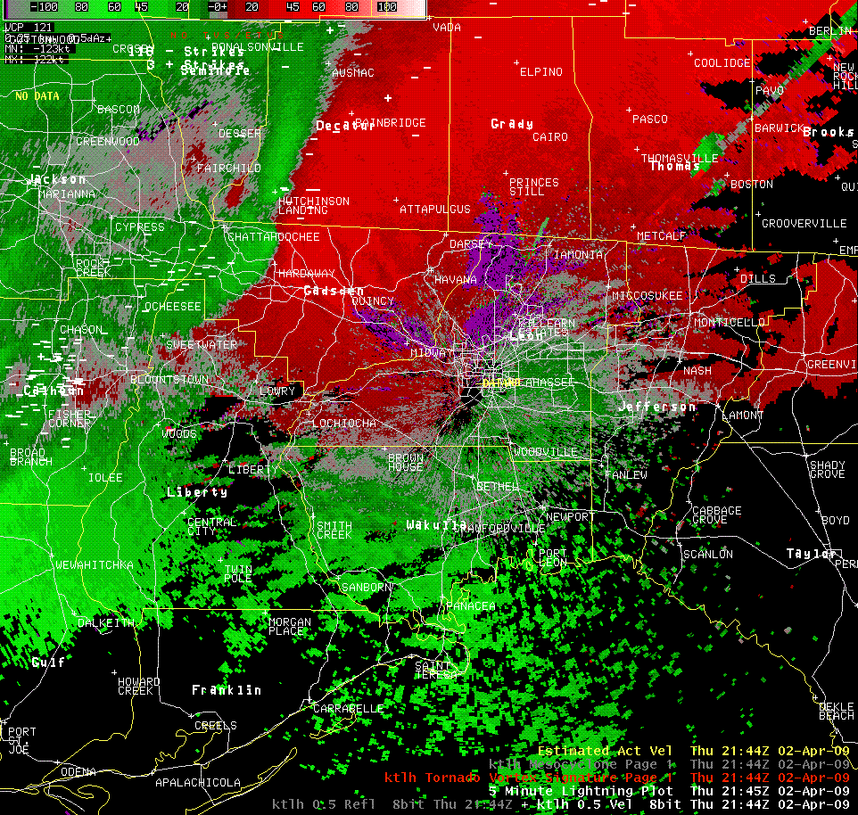
Figure 4. Radar loop of Tallahassee WSR-88D Radial Velocity beginning 2 April 2009, 2144 UTC (5:45 pm EDT) and ending at 2359 UTC (7:59 pm EDT). Cloud-to-ground lightning indicated by white + and - signs.
2. The South Georgia April 5th hailstorm.
A small cluster of severe thunderstorms cut a swath across South Georgia on Sunday afternoon, April 5, 2009, between 1600 and 1900 UTC (noon and 3 pm EDT). Hail reports began in Dougherty County and continued east into Tift County before the severe storm moved into NWS Jacksonville's forecast area. The largest hail reports were of golfball size in Tift County (see Fig. 6). A brief tornado touchdown was reported in Berrien and Atkinson Counties associated with the same cluster of storms. The Moody AFB radar reflectivity image at 1950 UTC (1:50 pm EDT) is shown in Figure 5. The highest reflectivity values (70-75 dBZ) are shown by the purple colors in the center of the image over the town of Tifton. The KTLH radar (not shown) actually had reflectivities as high as 81 dBZ for this storm. These values are indicative of large hail.
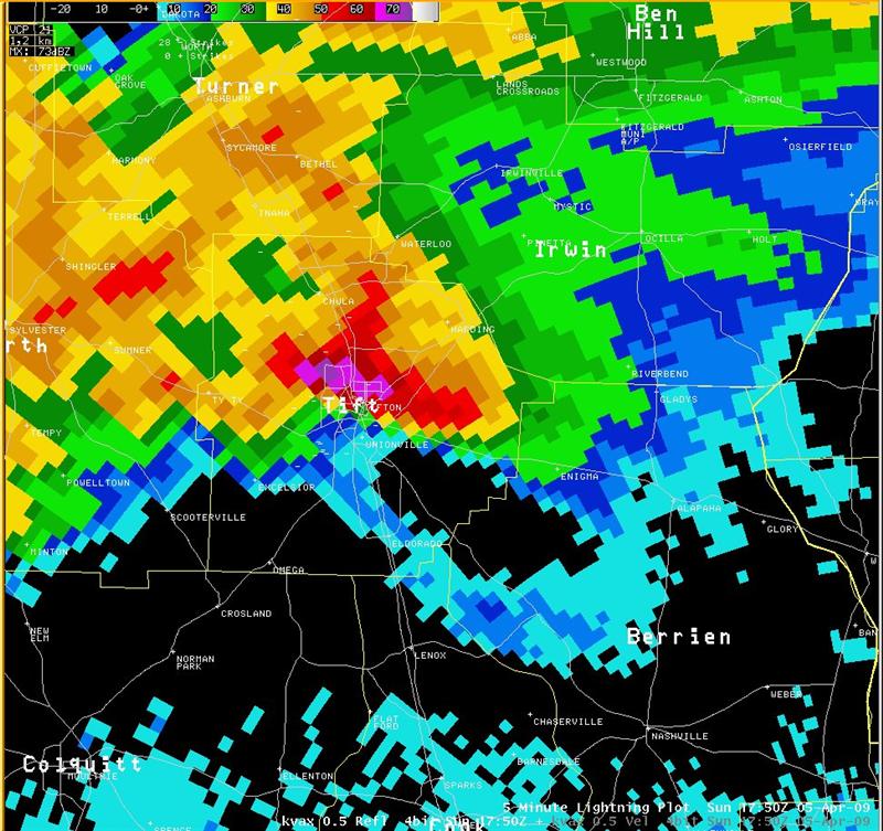
Figure 5. Radar Reflectivity image of Moody AFB WSR-88D at 5 April 2009, 1750 UTC (1:50 pm EDT).
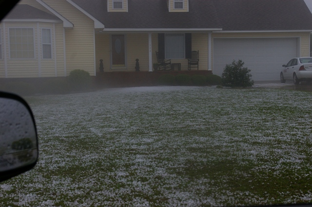
Figure 6. Hail stones litter the ground in Tifton, GA, from a hail storm that pummeled the town on the afternoon of 5 April 2009.
The following local storm reports contains additional details on the severe weather reports for these recent events.

