| Severe Weather of February 24, 2012 |
Severe weather and flooding occurred across the Southeast U.S. on 24 February 2012 including portions of the NWS Tallahassee County Warning Area (CWA). This was just over five days after another severe weather event impacted the region on 18-19 February. Figure 1 shows all of the severe weather reports that came into NWS offices across the nation. As can be see in the graphic, the vast majority of the reports were straight line wind damage.
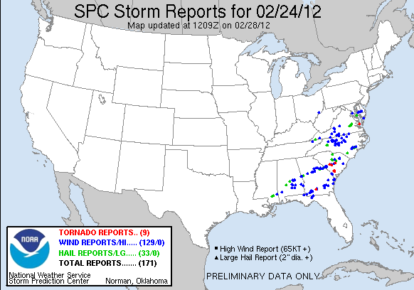
Figure 1. Storm reports relayed to the NWS on 24 February 2012 after 7:00 AM EST (1200 UTC).
WFO Tallahassee issued a total of 15 convective warnings during the event (12 severe and 3 tornado) and a special marine warning. Of the 15 warnings, 10 were verified. The average lead time was 16-17 minutes. Details on the damage reports received by the office can be found in our summary preliminary local storm report. Figure 2 depicts all of the warnings (polygons) issued by WFO Tallahassee during the event, with severe weather reports overlaid. The severe reports came in during a roughly 2.5-hour period beginning just before 12:00 PM EST (1700 UTC) 24 February.
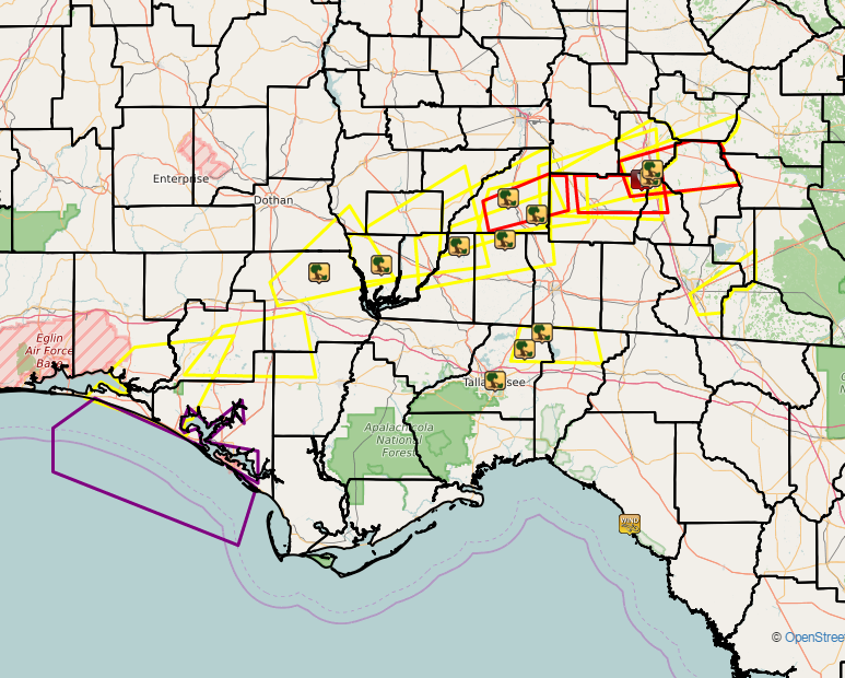
Figure 2. Warning polygons issued by WFO Tallahassee on 24 February 2012. Severe (yellow), tornado (red), and special marine (purple) warnings are depicted. Locations of reported severe weather are shown by the icons. Click for a larger view.
Fortunately, there was only one tornado that touched down during the event. An EF-0 tornado was confirmed in Colquitt County about 4 miles east-southeast of Omega, GA. Figure 3 shows radar imagery from the KTLH radar valid at 1:28 PM EST (1828 UTC). The elevation of each "slice" increases in a clockwise fashion from the top left. Notice the prominent bounded weak echo region (BWER) indicative of very strong updrafts in the cell as it approaches Norman Park, GA.
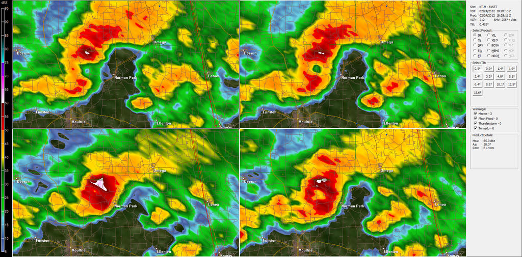
FIigure 3. Radar imagery from the Tallahassee (KTLH) Doppler radar valid 1:28 PM EST (1828 UTC) 24 February 2012. Base reflectivity is depicted in each panel with the 0.5-degree slice in the top left; 0.9-degree in the top right; 1.3-degree in the bottom right; and, 1.8-degree in the bottom left panel.
Figure 4 shows radar imagery from the KVAX radar about 18 minutes later when the tornado was on the ground. Notice the hook-shaped reflectivity in the left panel and strong (106-kt) rotational shear evident in the right panel. Fortunately, the tornado apparently lifted before reaching nearby Interstate 75. Figure 5 shows our estimate of the tornado's damage path between Omega and Lenox, GA. Figures 6 and 7 show damage to a mobile home park that was in the path of this tornado. Note that one home was completely destroyed. One woman posted a dramatic account of her encounter with the tornado on the WALB-TV Facebook page. She was driving her vehicle on Lawyer Summer Road when the tornado hit. It blew out the windows in her car and shoved the entire vehicle down the road. Fortunately, the driver and her passenger escaped without serious injury. In fact there were no injuries reported during the severe weather event of 24 February 2012.
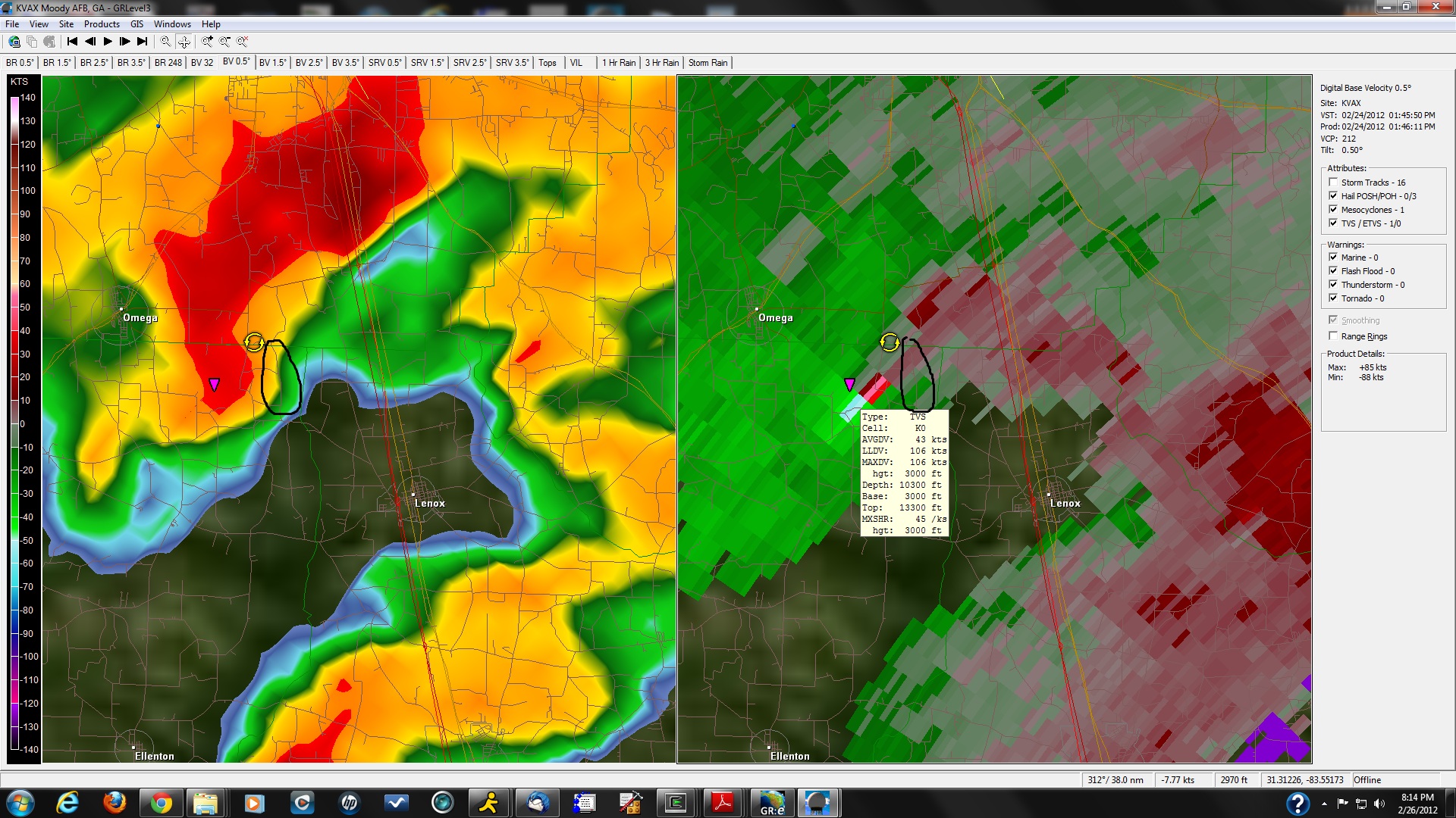
Figure 4. Radar imagery from the Moody AFB (KVAX) Doppler radar valid 1:46 PM EST (1846 UTC) 24 February 2012. Base reflectivity is depicted in the left panel with base velocity to the right.
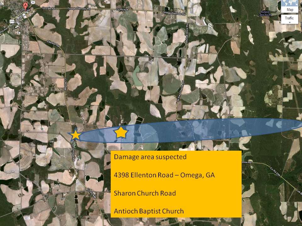
Figure 5. Suspected damage swath from the tornado that touched down in Colquitt County, GA, on 24 February 2012. Damage photos below were taken at the starred locations.

Figure 6. Damage in a mobile home park southeast of Omega, GA, from the tornado that ripped through the area on 24 February 2012.

Figure 7. Damage in a mobile home park southeast in Colquitt County, GA, from the tornado that moved through the area on 24 February 2012.
Page created by Mark Wool. Thanks go to Don Van Dyke for the warning verification information and Kelly Godsey for the damage track maps.

