Widespread showers and thunderstorms may produce isolate instances of flash flooding across the Ozarks and Southeast through Friday. Scattered severe storms and heavy rain is expected across the Northwest U.S.. Gusty winds and low relative humidity will contribute to elevated fire weather over a portion of the northern Plains with a secondary threat in the Great Basin. Read More >

- Do not use to report tornadoes, flash floods, and other extreme life-threatening situations. Call the National Weather Service to talk to a forecaster directly


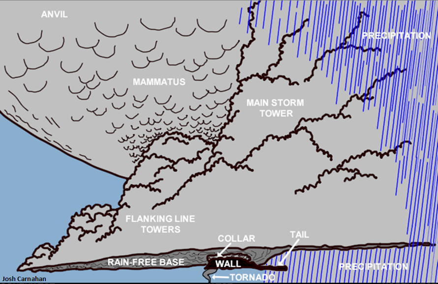
| Wall Clouds | Shelf Clouds |
| Located below storm updraft | Located around storm downdraft |
| Toward back of storm | At leading edge of storm |
| Rotates horizontally | Doesn't rotate |
| Winds blow toward and upward into wall cloud | Winds blow downward and away from shelf cloud |
| Description of Damage | Speed (mph) |
| Large branches move, telephone lines whistle | 25-31 |
| Whole trees move, difficult to walk against the wind | 32-38 |
| Twigs break of trees, wind impedes walking | 39-54 |
| Chimneys and TV antennas damaged, shallow-rooted trees uprooted | 55-72 |
| Roof surfaces peel off, windows break, mobile homes overturn | 73-112 |
| House roofs tear off, weak buildings and mobile homes destroyed, large trees uprooted | over 113 |
| Description of Hail | Diameter (inches) |
| Pea | 1/2 |
| Penny, mothball | 3/4 |
| Nickel | 7/8 |
| Quarter | 1 |
| Half-dollar | 1 1/4 |
| Silver dollar, ping-pong ball, walnut | 1 1/2 |
| Golf ball | 1 3/4 |
| Tennis ball, snuff can | 2 1/2 |
| Baseball | 2 3/4 |
| Tea cup | 3 |
| Grapefruit | 4 |
| Softball | 4 1/2 |