Overview
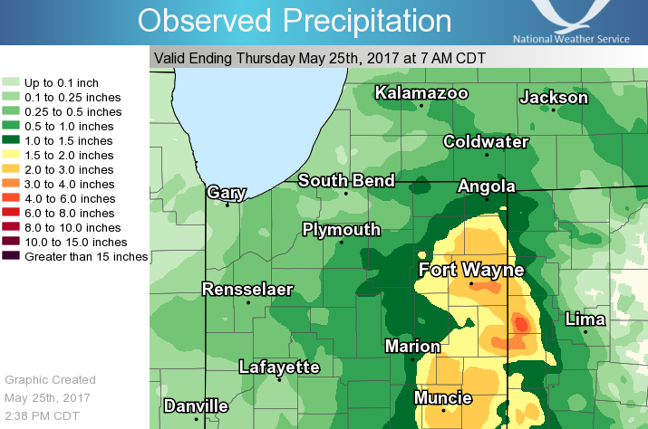
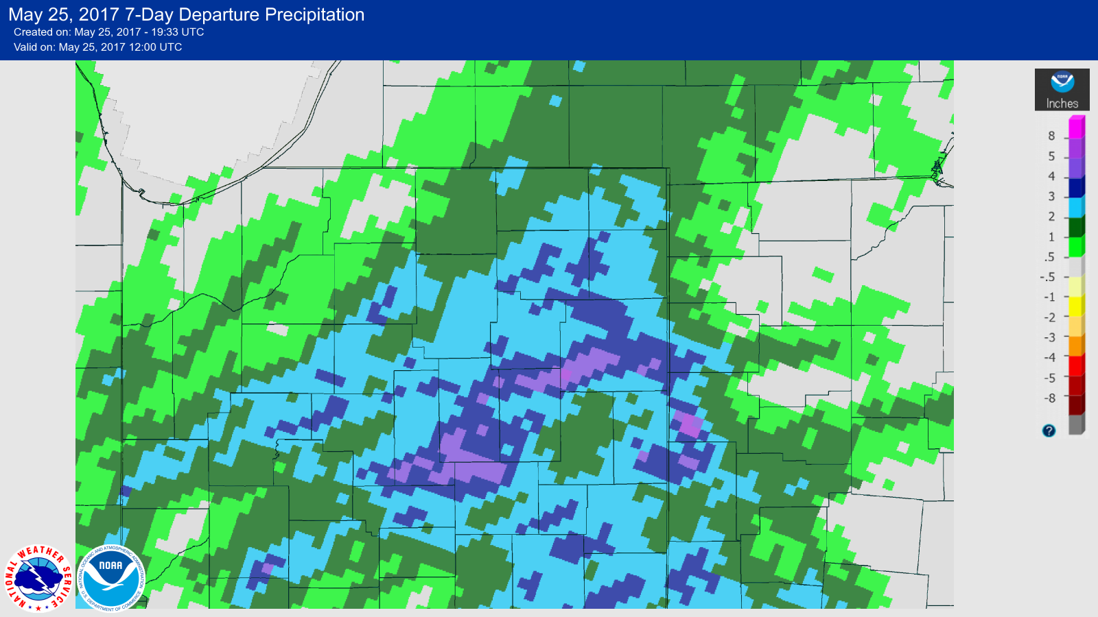
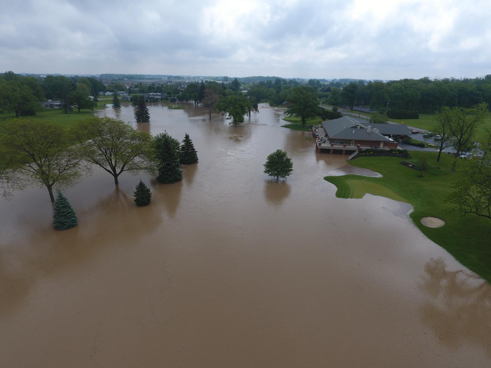
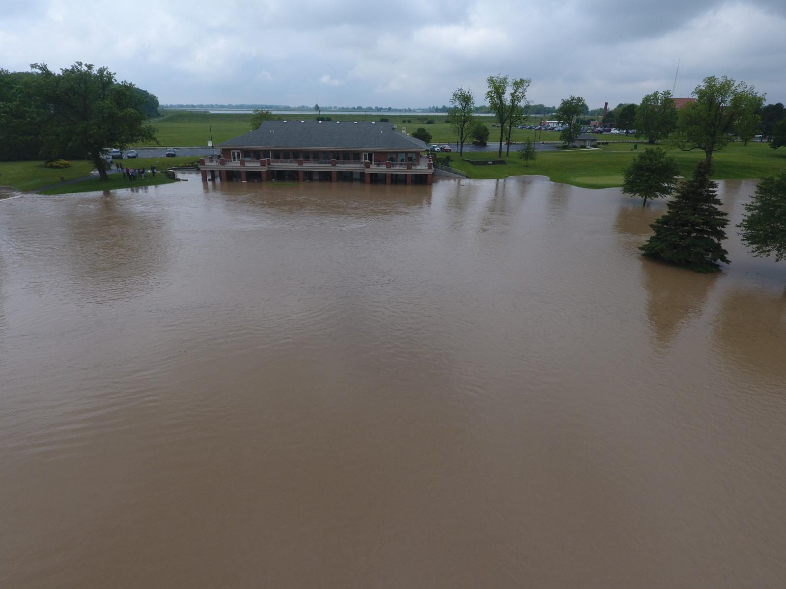
Very heavy rainfall occurred across portions of northwest Ohio and northeast Indiana from the afternoon of May 24th to the early morning hours of May 25th. A corridor of 3 to 6 inches of storm total rainfall occurred from western Van Wert county Ohio to central Allen county Indiana, with localized amounts of 6 to 8 inches across southwest Van Wert county. This very heavy rainfall led to flooding and flash flooding, along with significant rises on some area rivers. The event of May 24th and May 25th is a continuation of a very active pattern recently, with above normal precipitation over the past month across much of northeast Indiana and northwest Ohio.Flooding
Precipitation/Hydrographs
 |
 |
 |
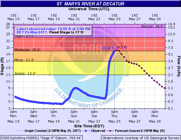 |
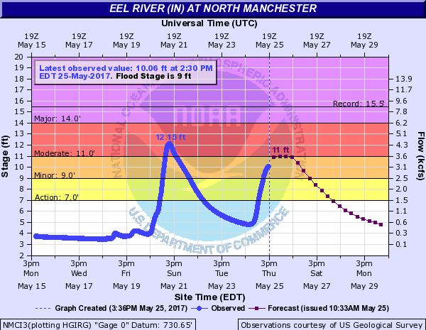
| Storm Total Rainfall | Rainfall Departure from Normal (Past 7 days) | North Manchester Hydrograph | Decatur Hydrograph |
Photos
 |
 |
 |
 |
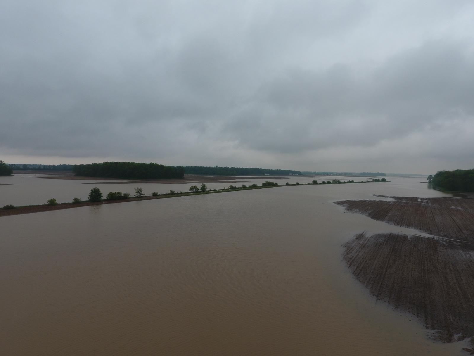
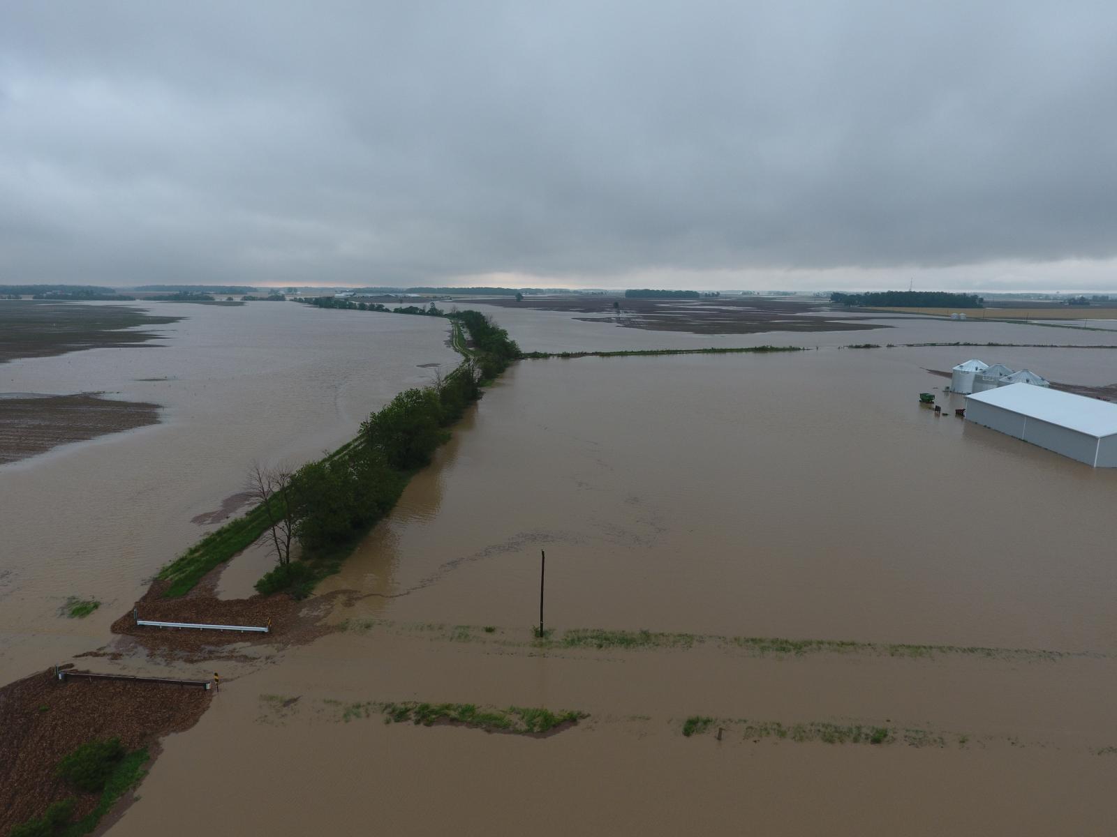
| Van Wert county - Rick McCoy | Van Wert county - Rick McCoy | Van Wert county - Rick McCoy | Van Wert county - Rick McCoy |
 |
 |
 |
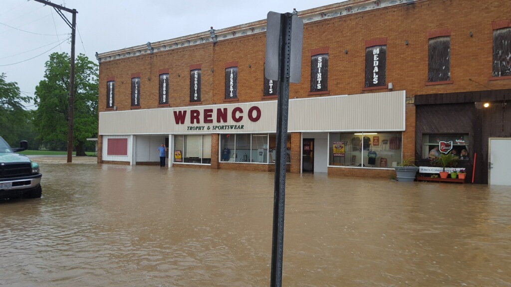 |
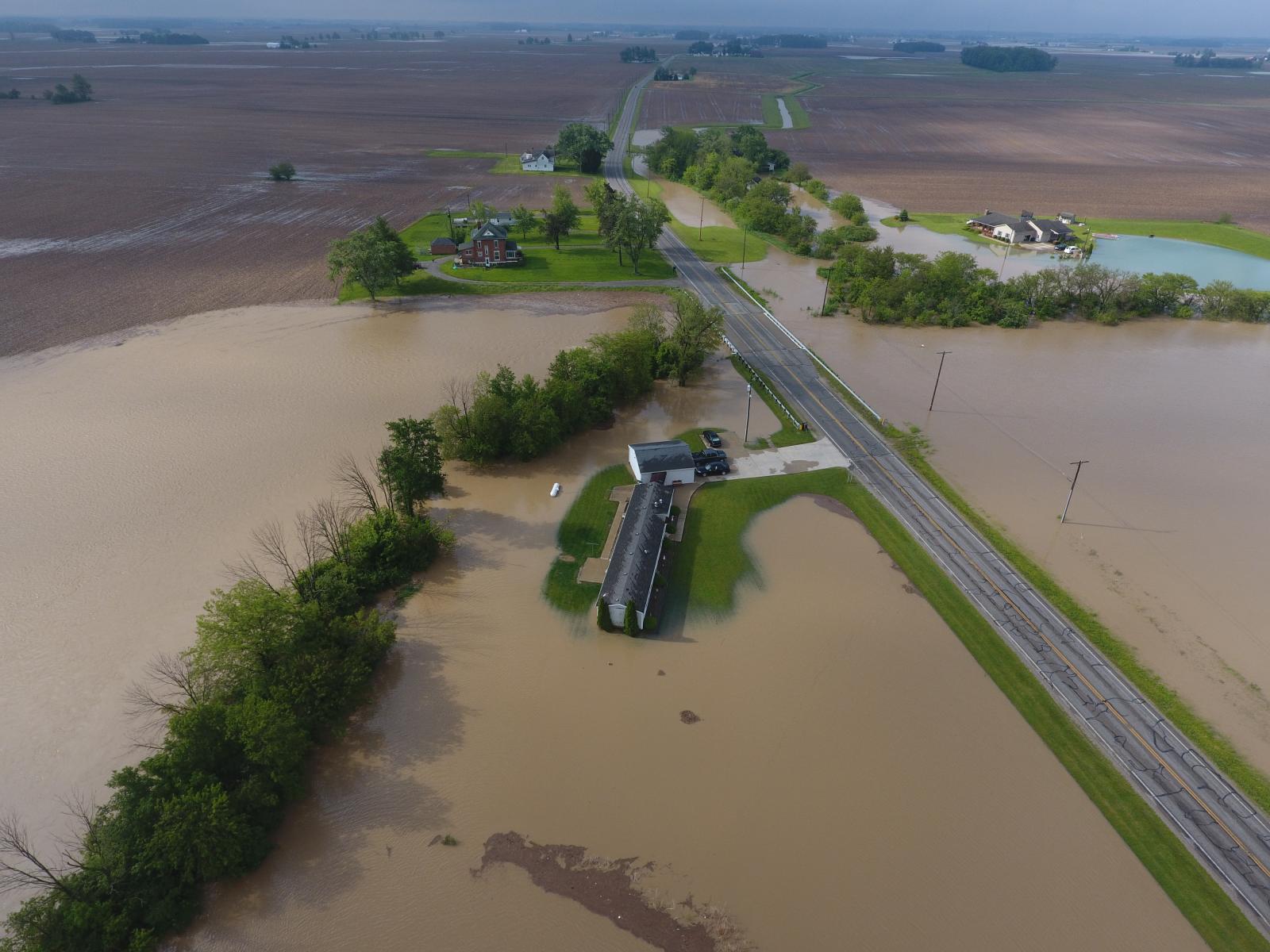
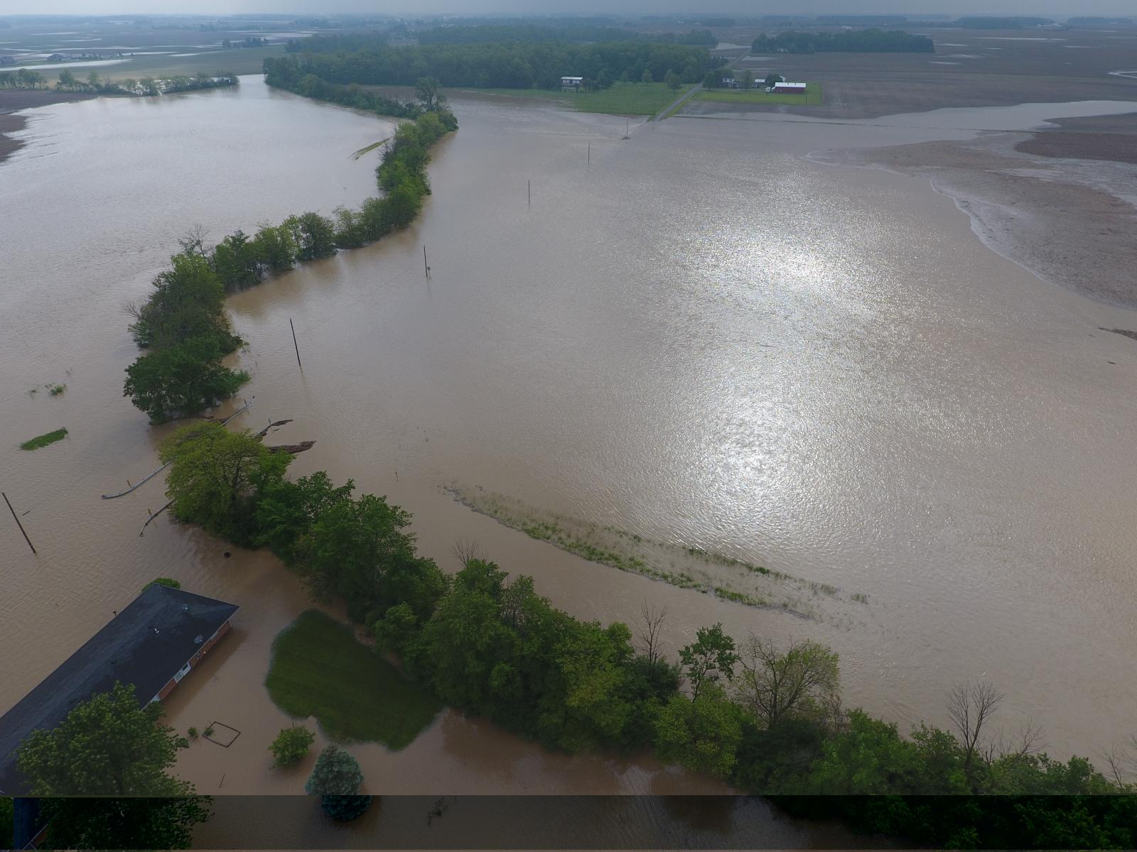
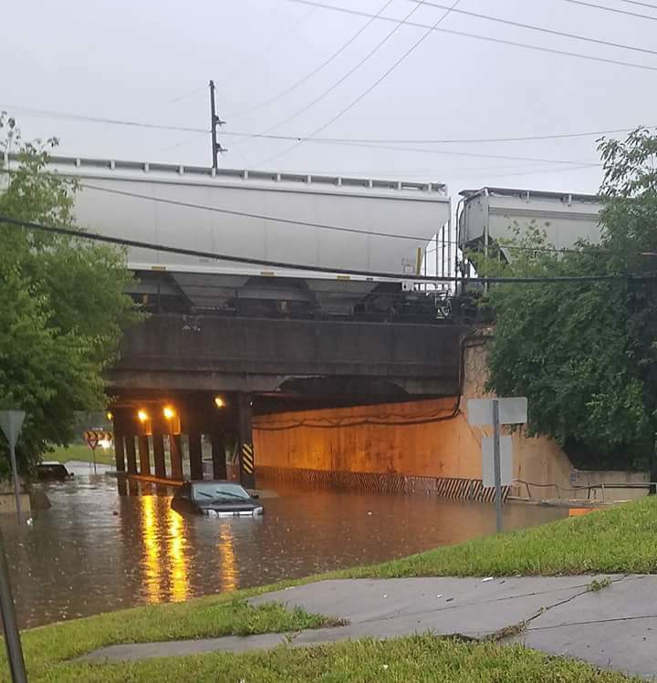
| Van Wert county - Rick McCoy | Van Wert county - Rick McCoy | Fort Wayne, IN near Pontiac - Paula Bales | Wren, OH - Rick McCoy |
Radar:
Radar loop from 2pm May 24 to 4am May 25
 |
| Radar loop from May 24th 2pm - May 25th 4am |
Storm Reports
PRELIMINARY LOCAL STORM REPORT...SUMMARY
NATIONAL WEATHER SERVICE NORTHERN INDIANA
302 PM EDT THU MAY 25 2017

..TIME...   ...EVENT...      ...CITY LOCATION...     ...LAT.LON...
..DATE...   ....MAG....      ..COUNTY LOCATION..ST.. ...SOURCE....
            ..REMARKS..

1243 AM     FLASH FLOOD      4 WNW COMO              40.41N 85.15W
05/25/2017                   JAY                IN   LAW ENFORCEMENT

            HIGH WATER ACROSS RD ALONG SR 1 AND 150 S.

0933 PM     FLASH FLOOD      1 SSE FORT WAYNE        41.06N 85.13W
05/24/2017                   ALLEN              IN   BROADCAST MEDIA

            FIRE DEPARTMENT USED A RAFT TO GET SOMEONE
            OUT OF THEIR CAR DUE TO FLOODED ROADWAY.

0920 PM     FLASH FLOOD      WREN                    40.80N 84.77W
05/24/2017                   VAN WERT           OH   EMERGENCY MNGR

            4 RESIDENTS EVACUATED AND MANY COUNTY ROADS
            ARE CLOSED.

0800 PM     FLASH FLOOD      WREN                    40.80N 84.78W
05/24/2017                   VAN WERT           OH   EMERGENCY MNGR

            STATE ROUTE 49 CLOSED DUE TO HIGH WATER AND
            FLOODING WAS IMPACTING SOME BUSINESSES IN
            WREN.

0733 AM     FLOOD            3 NW WALLEN             41.19N 85.21W
05/25/2017                   ALLEN              IN   NWS EMPLOYEE

            SEVERAL LOW SPOTS WITH COUPLE INCHES FLOWING
            WATER ALONG CARROLL RD. BETWEEN US 33 AND 3.
            LOTS OF STANDING WATER IN FIELDS.

0706 PM     FLOOD            4 NE NINE MILE          41.01N 85.17W
05/24/2017                   ALLEN              IN   PUBLIC

            WATER COVERING ROADWAY.

0627 AM     FLOOD            2 E PLEASANT MILLS      40.78N 84.81W
05/25/2017                   ADAMS              IN   COUNTY OFFICIAL

            *** 2 INJ ***
            A VEHICLE IN THE WATER WITH TWO VICTIMS AT
            225 N AND PIQUA RD. THE VICTIMS WERE RESCUED
            AND SENT TO THE HOSPITAL.

0959 AM     FLOOD            1 NE FORT WAYNE         41.09N 85.12W
05/25/2017                   ALLEN              IN   COUNTY OFFICIAL

            BODY FOUND IN THE RIVER. UNKNOWN IF IT WAS
            AS A RESULT OF FLOODING IN THE AREA.

0645 AM     FLOOD            NEW HAVEN               41.07N 85.03W
05/25/2017                   ALLEN              IN   BROADCAST MEDIA

            SR 930 FLOODED AT HARTZELL IN NEW HAVEN.

0513 PM     HAIL             2 W ELKHART             41.69N 86.00W
05/24/2017  E0.75 INCH       ELKHART            IN   PUBLIC
Rain Reports
Public Information Statement
National Weather Service Northern Indiana
259 PM EDT Thu May 25 2017

...Rainfall Reports Last 36 Hours...

Location                     Amount    Time/Date       Lat/Lon

...Indiana...

...Adams County...
Linn Grove                   2.36 in   0145 PM 05/25   40.66N/85.03W
Linn Grove                   1.82 in   1045 PM 05/24   40.66N/85.03W

...Allen County...
1 S Fort Wayne               5.35 in   0103 AM 05/25   41.05N/85.14W
2 SE New Haven               4.40 in   1039 AM 05/25   41.05N/85.00W
3 NE Nine Mile               3.83 in   0230 PM 05/25   41.02N/85.18W
3 NE Nine Mile               3.81 in   0840 AM 05/25   41.02N/85.18W
3 NE Nine Mile               3.80 in   1040 AM 05/25   41.02N/85.18W
3 SW Leo-cedarville          3.52 in   0930 AM 05/25   41.17N/85.05W
3 SW Leo-cedarville          3.50 in   0930 AM 05/25   41.17N/85.05W
2 SE New Haven               3.47 in   1259 AM 05/25   41.05N/85.01W
4 NE Nine Mile               3.31 in   0109 AM 05/25   41.02N/85.18W
2 WSW Maples                 3.30 in   0700 AM 05/25   40.99N/85.00W
2 WSW Maples                 3.30 in   0700 AM 05/25   40.99N/85.00W
2 ESE Huntertown             3.29 in   0700 AM 05/25   41.21N/85.12W
2 ESE Huntertown             3.29 in   0700 AM 05/25   41.21N/85.12W
3 NW Fort Wayne              3.24 in   0600 AM 05/25   41.11N/85.17W
3 NW Wallen                  3.24 in   0915 AM 05/25   41.19N/85.21W
3 NNW Fort Wayne             3.24 in   0915 AM 05/25   41.11N/85.17W
2 NE Fort Wayne              3.15 in   0730 AM 05/25   41.10N/85.11W
2 WNW Leo-cedarville         3.10 in   0800 AM 05/25   41.22N/85.06W
3 NE Nine Mile               3.05 in   1130 PM 05/24   41.02N/85.18W
2 SSE New Haven              3.05 in   1153 PM 05/24   41.05N/85.01W
2 WNW Leo-cedarville         3.04 in   0800 AM 05/25   41.22N/85.06W
2 SSW Huntertown             2.98 in   1039 AM 05/25   41.20N/85.19W
2 W Woodburn                 2.84 in   0700 AM 05/25   41.12N/84.91W
2 W Woodburn                 2.84 in   0700 AM 05/25   41.12N/84.91W
1 NNE Rolling Hills          2.81 in   0738 AM 05/25   41.05N/85.25W
1 NNE Rolling Hills          2.81 in   0738 AM 05/25   41.05N/85.25W
Woodburn 3n                  2.80 in   0700 AM 05/25   41.16N/84.85W
Woodburn 3n                  2.80 in   0700 AM 05/25   41.16N/84.85W
1 N Rolling Hills            2.79 in   0800 AM 05/25   41.05N/85.27W
1 N Rolling Hills            2.79 in   0800 AM 05/25   41.05N/85.27W
3 NW Fort Wayne              2.77 in   1032 PM 05/24   41.10N/85.18W
Fort Wayne 1.3 NNW           2.44 in   0602 AM 05/25   41.09N/85.15W
4 N New Haven                2.40 in   0245 PM 05/25   41.13N/85.03W
3 NW Fort Wayne              2.36 in   1055 PM 05/24   41.10N/85.19W
5 NNW New Haven              2.30 in   0903 PM 05/24   41.14N/85.06W
Woodburn                     2.12 in   0235 PM 05/25   41.14N/84.86W
Woodburn                     2.12 in   0835 AM 05/25   41.14N/84.86W
Woodburn                     2.11 in   1035 AM 05/25   41.14N/84.86W
3 NW Fort Wayne              2.11 in   0916 PM 05/24   41.10N/85.18W
2 SE Dunfee                  2.00 in   1052 PM 05/24   41.06N/85.31W
4 N New Haven                1.91 in   1135 PM 05/24   41.13N/85.03W
2 SSW Huntertown             1.91 in   1126 PM 05/24   41.20N/85.19W
Fort Wayne International Ap  1.69 in   0754 AM 05/25   40.98N/85.20W
Fort Wayne International Ap  1.67 in   0754 AM 05/25   40.98N/85.20W
Rolling Hills                1.57 in   0902 PM 05/24   41.03N/85.29W
Rolling Hills                1.57 in   0902 PM 05/24   41.03N/85.29W
Fort Wayne 4.1 NE            1.47 in   0700 AM 05/25   41.12N/85.09W
Fort Wayne 4.1 NE            1.46 in   0700 AM 05/25   41.12N/85.09W
Woodburn                     1.38 in   1119 PM 05/24   41.14N/84.86W
Fort Wayne International Ap  1.08 in   0754 PM 05/24   40.98N/85.20W

...Blackford County...
Hartford City                2.28 in   0700 AM 05/25   40.45N/85.37W
Hartford City                2.28 in   0700 AM 05/25   40.45N/85.37W
(kc9dcr)hartford City 0.3 SS 2.27 in   0700 AM 05/25   40.45N/85.37W
(kc9dcr)hartford City 0.3 SS 2.27 in   0700 AM 05/25   40.45N/85.37W
Hartford City                2.13 in   0800 AM 05/25   40.46N/85.37W
Hartford City                2.13 in   0800 AM 05/25   40.46N/85.37W
Hartford City                2.10 in   0700 AM 05/25   40.46N/85.37W
Hartford City                2.10 in   0700 AM 05/25   40.46N/85.37W
3 SW Roll                    1.74 in   0700 AM 05/25   40.51N/85.43W

...De Kalb County...
Auburn                       2.14 in   0600 AM 05/25   41.37N/85.05W
Auburn                       2.14 in   0600 AM 05/25   41.37N/85.05W
Butler 1se                   1.88 in   0910 AM 05/25   41.41N/84.85W

...Fulton County...
2 NW Rochester               1.00 in   0700 AM 05/25   41.09N/86.23W
2 NW Rochester               1.00 in   0700 AM 05/25   41.09N/86.23W

...Grant County...
3 NW Shamrock Lakes          2.19 in   0700 AM 05/25   40.45N/85.45W
3 NW Shamrock Lakes          2.18 in   0700 AM 05/25   40.45N/85.45W
Upland                       1.93 in   0700 AM 05/25   40.47N/85.50W
Upland                       1.93 in   0700 AM 05/25   40.47N/85.50W
Fairmount                    1.65 in   0700 AM 05/25   40.42N/85.64W
Fairmount                    1.65 in   0700 AM 05/25   40.42N/85.64W
(kb9cra)gas City 0.3 N       1.18 in   0700 AM 05/25   40.49N/85.61W
2 E Jalapa                   1.02 in   0800 AM 05/25   40.62N/85.71W
1 NW Marion                  1.02 in   0730 AM 05/25   40.57N/85.69W

...Huntington County...
1 ENE Warren                 1.75 in   0700 AM 05/25   40.70N/85.40W
1 ENE Bowerstown             1.45 in   0200 PM 05/25   40.90N/85.41W
1 ENE Bowerstown             1.44 in   1000 AM 05/25   40.90N/85.41W
2 NW Warren                  1.35 in   0145 PM 05/25   40.71N/85.45W
1 ENE Bowerstown             1.32 in   0800 AM 05/25   40.90N/85.41W
2 NW Warren                  1.31 in   0945 AM 05/25   40.71N/85.45W
2 NW Warren                  1.13 in   0745 AM 05/25   40.71N/85.45W
Huntington                   1.08 in   0700 AM 05/25   40.88N/85.51W
Huntington                   1.02 in   0630 AM 05/25   40.86N/85.50W
Huntington                   1.02 in   0630 AM 05/25   40.86N/85.50W
(wa9qgl)andrews 3.2 ESE      1.00 in   0700 AM 05/25   40.84N/85.55W

...Jay County...
1 SSW Blaine                 2.00 in   0700 AM 05/25   40.39N/85.06W
1 SSW Blaine                 2.00 in   0700 AM 05/25   40.39N/85.06W
College Corner               1.95 in   0700 AM 05/25   40.40N/84.98W
2 N Westchester              1.77 in   0107 AM 05/25   40.52N/84.89W
1 W Boundary City            1.61 in   0700 AM 05/25   40.35N/84.95W

...Kosciusko County...
1 E Winona Lake              1.23 in   0500 AM 05/25   41.22N/85.79W
1 E Winona Lake              1.22 in   0500 AM 05/25   41.22N/85.79W
2 SW Warsaw                  1.17 in   0839 AM 05/25   41.21N/85.87W
1 E Claypool                 1.13 in   0600 AM 05/25   41.13N/85.86W
1 NNW Warsaw                 1.12 in   0700 AM 05/25   41.25N/85.86W
1 N Warsaw                   1.09 in   0600 AM 05/25   41.26N/85.85W
1 N Warsaw                   1.09 in   0600 AM 05/25   41.26N/85.85W

...Lagrange County...
2 WNW Elmira                 1.62 in   0700 AM 05/25   41.60N/85.24W
2 E Brushy Prairie           1.57 in   0700 AM 05/25   41.64N/85.20W
2 E Brushy Prairie           1.57 in   0700 AM 05/25   41.64N/85.20W
Brushy Prairie               1.28 in   0600 AM 05/25   41.65N/85.23W

...Marshall County...
Plymouth                     4.10 in   0535 AM 05/25   41.34N/86.31W
Plymouth                     4.00 in   1118 PM 05/24   41.34N/86.31W
Bourbon 0.4 S                1.35 in   0600 AM 05/25   41.29N/86.12W
2 W Mentone                  1.06 in   0848 AM 05/25   41.18N/86.08W

...Noble County...
1 E Big Lake                 1.91 in   0700 AM 05/25   41.28N/85.47W
1 E Big Lake                 1.91 in   0700 AM 05/25   41.28N/85.47W
Kendallville                 1.85 in   0700 AM 05/25   41.44N/85.26W
Kendallville                 1.85 in   0700 AM 05/25   41.44N/85.26W
3 NE Avilla                  1.78 in   0839 AM 05/25   41.40N/85.20W
2 E Albion                   1.75 in   0830 AM 05/25   41.40N/85.37W
Albion 3.7 S                 1.71 in   0930 AM 05/25   41.34N/85.42W
Albion 3.7 S                 1.71 in   0930 AM 05/25   41.34N/85.42W
3 N Kendallville             1.71 in   0700 AM 05/25   41.49N/85.26W
1 E Big Lake                 1.59 in   0830 AM 05/25   41.28N/85.47W
2 E Rome City                1.50 in   0700 AM 05/25   41.50N/85.31W
2 E Rome City                1.50 in   0700 AM 05/25   41.50N/85.31W
Albion                       1.39 in   0800 AM 05/25   41.40N/85.41W
Albion                       1.39 in   0800 AM 05/25   41.40N/85.41W
3 NE Avilla                  1.34 in   1123 PM 05/24   41.40N/85.20W
Avilla 3sw                   1.15 in   0830 PM 05/24   41.35N/85.30W

...Steuben County...
2 ENE Crooked Lake           2.17 in   0615 AM 05/25   41.70N/84.99W
2 ENE Crooked Lake           2.17 in   0615 AM 05/25   41.70N/84.99W
2 WSW Golden Lake            1.84 in   0600 AM 05/25   41.59N/85.10W
2 WSW Golden Lake            1.84 in   0600 AM 05/25   41.59N/85.10W
Angola                       1.67 in   0700 AM 05/25   41.64N/84.99W
Angola                       1.67 in   0700 AM 05/25   41.64N/84.99W
2 W Silver Lake              1.60 in   0115 PM 05/25   41.63N/85.11W
2 W Silver Lake              1.60 in   0815 AM 05/25   41.63N/85.11W
1 W Golden Lake              1.59 in   0700 AM 05/25   41.60N/85.09W
1 SE Crooked Lake            1.58 in   0248 PM 05/25   41.66N/85.02W
1 SE Crooked Lake            1.57 in   0848 AM 05/25   41.66N/85.02W
Hudson                       1.54 in   0708 AM 05/25   41.53N/85.08W
Hudson                       1.54 in   0708 AM 05/25   41.53N/85.08W
Metz                         1.50 in   0700 AM 05/25   41.61N/84.84W
Metz                         1.49 in   0700 AM 05/25   41.61N/84.84W
1 E Hamilton                 1.46 in   0700 AM 05/25   41.53N/84.89W
1 E Hamilton                 1.44 in   0700 AM 05/25   41.53N/84.89W
1 SE Crooked Lake            1.33 in   1138 PM 05/24   41.66N/85.02W
2 W Silver Lake              1.28 in   1015 PM 05/24   41.63N/85.11W
1 S Angola                   1.28 in   0600 AM 05/25   41.62N/85.00W
1 S Angola                   1.28 in   0600 AM 05/25   41.62N/85.00W

...Wells County...
Bluffton                     2.04 in   0945 AM 05/25   40.74N/85.17W
Bluffton                     2.04 in   0945 AM 05/25   40.74N/85.17W
Bluffton                     2.03 in   0845 AM 05/25   40.74N/85.17W
Craigville 2.7 NW            1.76 in   0800 AM 05/25   40.80N/85.13W
1 NNE Bluffton               1.72 in   0620 AM 05/25   40.76N/85.16W
Bluffton                     1.67 in   0700 AM 05/25   40.73N/85.16W
Bluffton                     1.67 in   0700 AM 05/25   40.73N/85.16W
Bluffton--main St. Bridge    1.58 in   0822 AM 05/25   40.74N/85.17W
2 W Ossian                   1.58 in   0800 AM 05/25   40.87N/85.21W
Bluffton--main St. Bridge    1.58 in   0822 AM 05/25   40.74N/85.17W
2 W Ossian                   1.56 in   0800 AM 05/25   40.87N/85.21W
Bluffton                     1.31 in   1045 PM 05/24   40.74N/85.17W

...Whitley County...
2 NE Tri-Lakes               1.68 in   0838 AM 05/25   41.25N/85.45W
1 ENE Peabody                1.59 in   0600 AM 05/25   41.09N/85.47W
1 ENE Peabody                1.59 in   0600 AM 05/25   41.09N/85.47W
1 NNW Tri-lakes              1.53 in   0630 AM 05/25   41.24N/85.49W
1 NNW Tri-lakes              1.53 in   0630 AM 05/25   41.24N/85.49W
Columbia City                1.36 in   0237 PM 05/25   41.16N/85.49W
Columbia City                1.32 in   0836 AM 05/25   41.16N/85.49W
Tri-lakes                    1.22 in   0847 AM 05/25   41.22N/85.48W

...Michigan...

...Hillsdale County...
1 SSE Montgomery             1.22 in   0800 AM 05/25   41.76N/84.79W
1 SSE Montgomery             1.19 in   0800 AM 05/25   41.76N/84.79W
Hillsdale                    1.18 in   0800 AM 05/25   41.94N/84.64W
Hillsdale                    1.17 in   0800 AM 05/25   41.94N/84.64W

...Ohio...

...Allen County...
Lima                         2.81 in   0230 PM 05/25   40.73N/84.12W
Lima                         2.81 in   0840 AM 05/25   40.73N/84.12W
Lima                         1.65 in   1120 PM 05/24   40.73N/84.12W

...Paulding County...
Grover Hill                  1.25 in   0700 AM 05/25   41.02N/84.48W
Grover Hill                  1.25 in   0700 AM 05/25   41.02N/84.48W

...Van Wert County...
Wren                         5.00 in   0919 PM 05/24   40.80N/84.77W
2 WNW Convoy                 4.52 in   0848 AM 05/25   40.93N/84.74W
Convoy                       2.35 in   1014 AM 05/25   40.93N/84.70W
1 ENE Van Wert               1.67 in   0247 PM 05/25   40.87N/84.56W
1 ENE Van Wert               1.67 in   0847 AM 05/25   40.87N/84.56W

...Williams County...
2 S Pioneer                  1.14 in   0700 AM 05/25   41.64N/84.55W
1 WSW Bryan                  1.04 in   0230 PM 05/25   41.46N/84.57W

Observations are collected from a variety of sources with varying
equipment and exposures. We thank all volunteer weather observers
for their dedication. Not all data listed are considered official.
 |
Media use of NWS Web News Stories is encouraged! Please acknowledge the NWS as the source of any news information accessed from this site. |
|

