Updated: July 27, 2012
(note: this document may be updated as more information is analyzed for this event)
During the afternoon and evening of Friday June 29, 2012, an intense, long-lived line of thunderstorms raced eastward at nearly 60 mph from the Midwest to the Mid-Atlantic coast. In its wake, these storms left behind a swath of destruction that killed at least 20 people, caused millions in property damage, and caused massive power outages in major urban areas along the storm’s path. Meteorologists use the term “derecho” to describe this special type of violent and long-lived windstorm.
Owing to the long-lived and destructive nature, and their immense distances travelled, meteorologists ascribe the term “derecho” (pronounced "deh-REY-cho") to these infrequent windstorms. The meaning of “derecho” is better known to those living in the central and southern plains of the United States, where derechos occur more frequently.
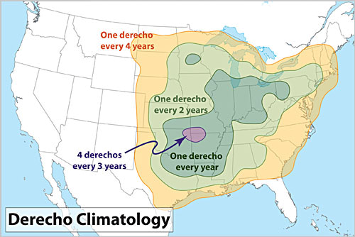
Because derechos are not common in our region, the term is relatively unknown to residents in the Mid-Atlantic. Typically, our region averages a derecho about once every 2 to 4 years, as shown in the graphic “Derecho Climatology” from the National Weather Service (NWS) Storm Prediction Center (SPC). The last significant derecho to hit the Washington DC-Baltimore metro region was on June 4, 2008.
This summary, using a question-answer format, provides general background on derechos and gives an overview of the derecho that struck the Mid-Atlantic on the evening of Friday, June 29, 2012. A more complete and thorough reference on derechos is available from the NWS Storm Prediction Center’s web site “About Derechos”:http://www.spc.noaa.gov/misc/AbtDerechos/derechofacts.htm. Some of the following information is derived from this SPC web site.
Essentially, a "derecho" is a long-lived, rapidly moving line of intense thunderstorms that produces widespread damaging winds in a nearly continuous swath.
By definition (according Johns and Hirt, 1987), the term “derecho” applies to a complex line of thunderstorms that travels a minimum distance of 240 miles (~400 km) or more, and produces a nearly continuous and widespread swath of damaging winds over that distance, with concentrated areas of wind speeds over 58 mph (93 km/hr). Surface wind gusts accompanying a derecho can often approach or exceed 100 mph.
The term “derecho” was originally coined over a century ago by a physics professor at the University of Iowa, named Dr. Gustavus Hinrichs, in a paper he published in the American Meteorological Journal in 1888. The term “derecho” is Spanish and means “straight ahead”, an attribute Dr. Hinrichs applied to the storm’s ability to produce damage from essentially straight-line winds. (Note: a fascinating description on how this term was developed by Dr. Hinrichs, and how it recently was revived can be found here:https://www.crh.noaa.gov/images/dvn/hinrichs/JohnsDerechoStory.pdf).
For a variety of reasons, the term “derecho” as defined in Dr. Hinrich’s original paper in 1888, never caught on with meteorologists of his time or in the years afterward. But a century later, in 1987, two forecasters, Robert Johns and Bill Hirt, with the NWS National Severe Storms Forecast Center (predecessor to today’s Storm Prediction Center), published a scientific paper that revived use of the term “derecho”. In their paper, Johns and Hirt properly used the term “derecho” to describe a number of long-path, non-tornadic damaging wind events they were studying.
Since publication of Johns and Hirt (1987), use of the term “derecho” has gained acceptance within the meteorological community. But because derechos are uncommon, the general public is not often exposed to hearing this term. And for those living outside of the Central U.S. and southern plains have probably never heard the term used. However, that all changed after June 29, 2012. Based on the recent experiences of massive power outages and widespread destruction resulting from the June 29 derecho, many residents in the Mid-Atlantic region and elsewhere are now more familiar with the term derecho.
Derechos can travel distances well over 250 miles (400 km). The recent derecho on June 29th travelled over 700 miles from its start in Iowa to the East Coast. A derecho on July 4-5, 1999 (known as the “Boundary Waters-Canadian Derecho”, travelled a distance of 1300 miles stretching from northern Minnesota across southern Canada before weakening as it exited off the coast of Maine. Derechos are best-recognized for their propensity to produce damaging winds over a fairly widespread region. They are also commonly prolific lightning producers.
Surface wind gusts of 50 to 75 mph are common with many derechos; some even produce surface wind gusts of over 100 mph!
While derechos characteristically produce widespread wind damage in a nearly continuous swath, actual surface winds vary along the track of a derecho. Not all locations within the path of a derecho will experience damage. The highest wind gusts occur with clusters of downbursts from the many thunderstorms that comprise the derecho. Often, narrow corridors, or channels, of higher wind gusts are observed within a derecho. Somewhat analogous to the discontinuous damage observed with tornadoes, where, e.g., structures on one side of a residential street might experience damage.
In short, no. Although derechos share some common characteristics, derechos occur in many variations. Consult SPC’s reference “About Derechos” for more details. Although not discussed here, there are two basic types of derechos: serial and progressive. For Friday’s event on the June 29th, this derecho is classified as a progressive derecho.
Note: A derecho is not to be confused with a long-lived supercell thunderstorm, as the processes that maintain the longevity of a supercell are different than those that maintain a long-lived derecho.
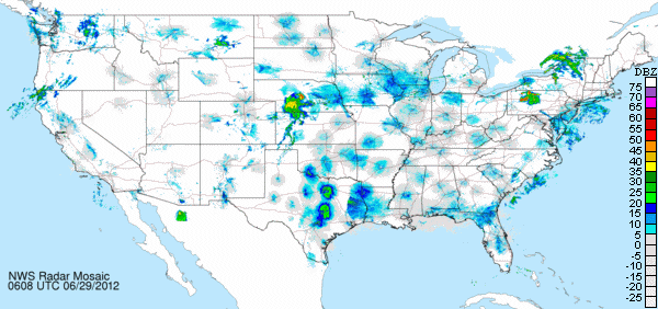
Viewed on radar, a derecho can easily cover large portions of a state or multiple states. They often take on a curved or bowed shape. Friday’s derecho of the 29th appears to have originated from thunderstorms that developed along an east-west oriented stationary front over Iowa and northern Illinois on Friday morning (between 09:00-11:00 AM EDT).
Below is an animated radar mosaic of NWS and DoD radars for the CONUS (continental United States). The loop runs from 02:08 AM EDT (0608 UTC) 29 June 2012 to 02:48 AM EDT (0648 UTC) on 30 June with a 10 minute interval.
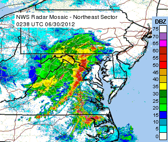
Viewed by satellite, derechos present an extensive cloud shield produced by the strong updrafts of the thunderstorms comprising a derecho. Below is an enhanced infra-red (IR) satellite image taken at 9:40 PM EDT Friday evening (0240 UTC-June 30, 2012) near the time of the above radar image (9:38 PM EDT). Overlaid on this image is the 15 minute sum of lightning cloud-to-ground strikes between 9:30 PM and 9:45 PM EDT. Nearly 1400 strikes are depicted on this image.

Here’s a link to an animation compiled by researchers at CIMMS (Cooperative Institute for Meteorological Satellite Studies; a cooperative institute between NOAA and the University of Wisconsin-Madison):
https://cimss.ssec.wisc.edu/goes/blog/wp-content/uploads/2012/06/120629-30_g13_ir_derecho_anim.gif
The animation contains data at roughly 15 to 30 minute intervals from the GOES 13 satellite imager. The loop depicts the 10.7 micro infrared channel, with the color scale depicting cloud-top temperatures (thunderstorms show up in the darker red-to black-to gray). The loop extents covers much of the lifetime of the derecho from its inception around 11:15 AM EDT (1515 UTC) Friday, June 29, 2012, through 3:30 AM EDT (0732 UTC) Saturday, June 30, 2012.
Derechos can travel at speeds upwards of 65 mph.
The derecho from June 29th produced wind gusts of 91 mph at Fort Wayne, Indiana, 82 mph at Dayton, Ohio. At the three DC-Baltimore metro region airports, Dulles gusted to 71 mph at 1023 PM EDT, Reagan National recorded a peak wind gust of 70 mph at 1048 PM, and BWI measured a peak gust of 66 mph 1102 PM.
Nearly three-quarters of derechos occurring in the United States form during the warm season months between April and October (however, derechos been observed anytime in the year).
Derechos move in roughly a linear fashion, although the can take sharp turns to the right or left. They often take on a bow-like appearance on radar.
Derechos often have two regions of damaging winds. The first area of damaging winds is associated with the gust front. This front, which is on the leading edge of the derecho, typically races out ahead of the main part of the derecho. Damaging winds from passage of the gust front can occur but usually only for a brief time (less than 1 minute). The second area of damaging winds occurs in the core of the derecho where typically the highest winds associated with the descent of moist air from upper levels of the storm rushes down to the surface in what is called a “rear inflow jet”. This “jet” of high winds can actually last for several minutes and typically produces the most destructive damage. The derecho of June 29th featured such a "rear inflow jet" that caused winds to blow strong (>40 mph) even 10 to 15 minutes after the main storm system had passed.
Derechos move through areas where the atmosphere is very unstable. During the summer months, derechos can form along the northern periphery of a hot and humid high pressure system.
A measure of atmospheric instability commonly used by meteorologists is CAPE (Convective Available PotentialEnergy). Research on derechos shows that CAPE values greater of ~4500 Joules/kg over a large area is needed to sustain a derecho during the summer months. On June 29, 2012, CAPE values of 4,000 to 6,000 Joules/kg were observed across the entire path the derecho travelled.
One particular aspect of the unstable atmospheric conditions experienced on June 29th was the occurrence of an "elevated mixed layer" (EML) between roughly 10,000 and 20,000 feet above ground over the Mid-Atlantic region. The vertical change of temperature, or lapse rate, measured in this layer aloft was roughly 9 degrees Celcius per 1 km in height. This "steepness" of this lapse rate resulted in vigorous thunderstorm updrafts associated with the derecho.
From SPC’s “About Derechos” web site:
“… Because derechos are most common in the warm season, those involved in outdoor activities are most at risk. Campers or hikers in forested areas are vulnerable to being injured or killed by falling trees. People in boats risk injury or drowning from storm winds and high waves that can overturn boats.
Those in cars and trucks also are vulnerable to being hit by falling trees and utility poles. High profile vehicles such as semi-trailer trucks, buses, and sport utility vehicles may be blown over. At outside events such as fairs and festivals, people may be killed or injured by collapsing tents and flying debris.
Even those indoors may be at risk for death or injury. Mobile homes, in particular, may be overturned or destroyed, while barns and similar buildings can collapse. People inside homes, businesses, and schools are sometimes victims of falling trees and branches that crash through walls and roofs; they also may be injured by flying glass from broken windows. Finally, structural damage to the building itself (for example, removal of a roof) could pose danger to those inside.
Another reason those outdoors are especially vulnerable to derechos is the rapid movement of the derecho. Typically, derecho-producing storm systems move at speeds of 50 mph or greater, and a few have been clocked at 70 mph. For someone caught outside, such rapid movement means that darkening skies and other visual cues that serve to alert one to the impending danger In summary, the advance notice given by a derecho often is not sufficient for one to take protective action. …”.
In addition, because falling trees and limbs bring down live power lines during a derecho, there's an enhanced threat of electrocution from those venturing outside immediately after the storm passes to come in contact with downed power lines. Seeing and/or avoiding downed power lines that might still be electrified is especially difficult in the darkness of night when the power is out (e.g., no street lighting).
From SPC’s “About Derechos” web site:
“…Of particular significance in urban areas is the vulnerability of electrical lines to high winds and falling trees. In addition to posing a direct hazard to anyone caught below the falling lines, derecho damage to overhead electric lines sometimes results in massive, long-lasting power outages. Hundreds of thousands of people may be affected; in the worst events, power may not be restored for many days. …”.
In the immediate aftermath of the June 29th, media reports estimated somewhere between 3.5 to 4 million customers were without power, with approximately 1.2 million customers in the DC metro region alone.
In addition, with this derecho, communications were disrupted across large areas, including the national Capital/DC region. In northern Virginia, loss of power to a key communications facility knocked out the 911 service for a period of time. Other communications issues were loss of telephone land lines, disruptions to celluar network calling, and scattered outages to in internet service among private, government and commercial sectors.
The NWS Storm Predicition Center worked with NWS field offices to issue four Severe Thunderstorm Watches a few hours in advance of the derecho to notify everyone for the potential of damaging winds. Warnings were issued when that potential turned to expectation. The majority of warnings issued from local NWS offices on Friday were severe thunderstorms warnings. Although a handful of tornado warnings were issued, there were only 2 confirmed reports of tornadoes associated with Friday’s derecho. Local NWS offices issue warnings in the form of polygons. Here is a plot of NWS office warnings for this derecho. When compared to the CONUS radar loop, it’s obvious where the bulk of warnings were issued.
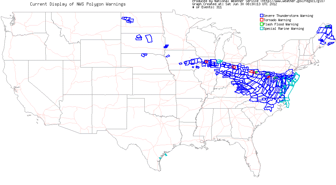
The NWS Baltimore/Washington Weather Forecast Office (WFO) issued 15 severe thunderstorm warnings, 2 tornado warnings, and 6 special marine warnings.The average lead time for all 15 severe thunderstorm warnings issued was approximately 37 minutes.
Severe Thunderstorm Warnings and Tornado Warnings both mean that there will be damage somewhere within that warned threat zone (by verification over 90% of the time). Anytime you have one of these warnings issued for where you are, you should seek shelter in a sturdy structure away from windows, in a low and central location (hopefully like a interior basement bathroom or closet). In our area, people most often are killed or injured by falling trees either landing on their vehicle or falling into the top floor of their home. A NOAA Weather Radio, which you can pick up at many big box stores or electronics stores, is a great way to receive life-threatening weather warnings that are affecting your county 24/7 (you program your county into it). While there are many ways to get warnings during the day, a weather radio is a great way to be alerted to these warnings when you aren't connected to the outside world - such as at night. You can also sign up for text alerts from many county governments, your local broadcast meteorologists, and/or private weather companies.
This derecho caused widespread damage covering multiple states. Much of the damage occurred when trees toppled on to structures, vehicles and powerlines. Here is a plot from the SPC showing all severe reports for 29 June 2012. There is a nearly continuous path of severe wind and wind damage reports extending from Iowa to northern Illinois across Indiana to Ohio to West Virginia to the Mid-Atlantic before exiting off the East Coast.
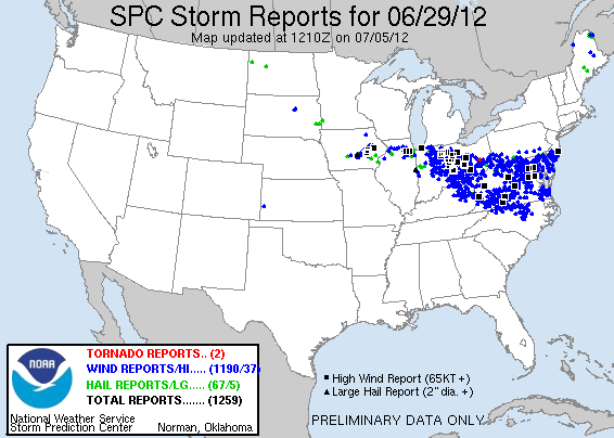
Nearly all of the reports extending from Iowa eastward to the Mid-Atlantic coast were caused by a single derecho. In the NWS Baltimore-Washington WFO area of responsibility, we received over 300 individual reports of damage; and continue to compile reports.
Forecasting derechos is still a challenge and an active area of research within the meteorological community. While meteorologists are better able to anticipate atmospheric conditions conducive to formation of derechos, forecasting the detailed timing of the onset of a derecho, along with its duration and intensity, and even its path, remains a challenge to forecasters today.
From SPC’s “About Derechos” web site:
“…Many meteorological factors, some acting synergistically and some seemingly at odds, may come together to yield an environment conducive to derechos. The variation of these factors over space and time also is important in fostering or hindering development. Two nearly identical meteorological settings might yield vastly different outcomes --- that is, a derecho or no derecho --- depending upon how the atmosphere evolved to that point in time.…”.
Better observational networks (including satellite, radar and surface observations), coupled with the running ensembles of high resolution numerical weather prediction models, offer hope that derechos will be forecast with more accuracy in the future.
Derechos are relatively uncommon to this region, especially ones of this magnitude. Typically, the Mid-Atlantic region might experience a derecho once every two to four years. The last significant derecho in our region occurred on June 4, 2008 (See Zubrick, et. al., 2009, for a review of the June 4,2008 event).
Realize that the vast majority of thunderstorms that impact our region will not be associated with a derecho. But, derechos can occur here and they could occur at any time; tomorrow, next week or next month, or not until several years from now. Monitoring your local NWS forecasts and media outlets is the best way to know if any future derecho or other types of severe weather could impact your location.
Steven Zubrick, Science and Operations Officer (SOO)
Email: Steven.Zubrick@noaa.gov
NOAA/National Weather Service, Baltimore-Washington DC Weather Forecast Office
Sterling, VA
References
Hinrichs, G., 1888: Tornadoes and derechos. Amer. Meteor. J., 5, 306-317, 341-349.
Johns, R. H., and W. D. Hirt, 1987: Derechos: widespread convectively induced windstorms. Wea. Forecasting, 2, 32-49.
Zubrick, S.M, G. M. Schoor, and M. Eckert, 2009: Analysis of the severe Mid-Atlantic Derecho of 04 June 2008. Presentation at the National Weather Association 2009 Annual Meeting, October 17-22, 2009, Norfolk, VA [abstract available here: https://www.nwas.org/meetings/abstracts/display.php?id=666]
Acknowledgements
The author wishes to thank Greg Carbin at NWS Storm Prediction Center, Jonathan Blaes, SOO at NWS-WFO Raleigh, Richard Grumm, SOO at NWS-WFO State College, and Chris Strong and Jared Klein at NWS-WFO Sterling.


 Coastal Flood
 FAQ
FAQ