Overview
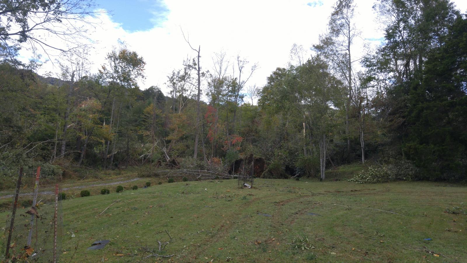
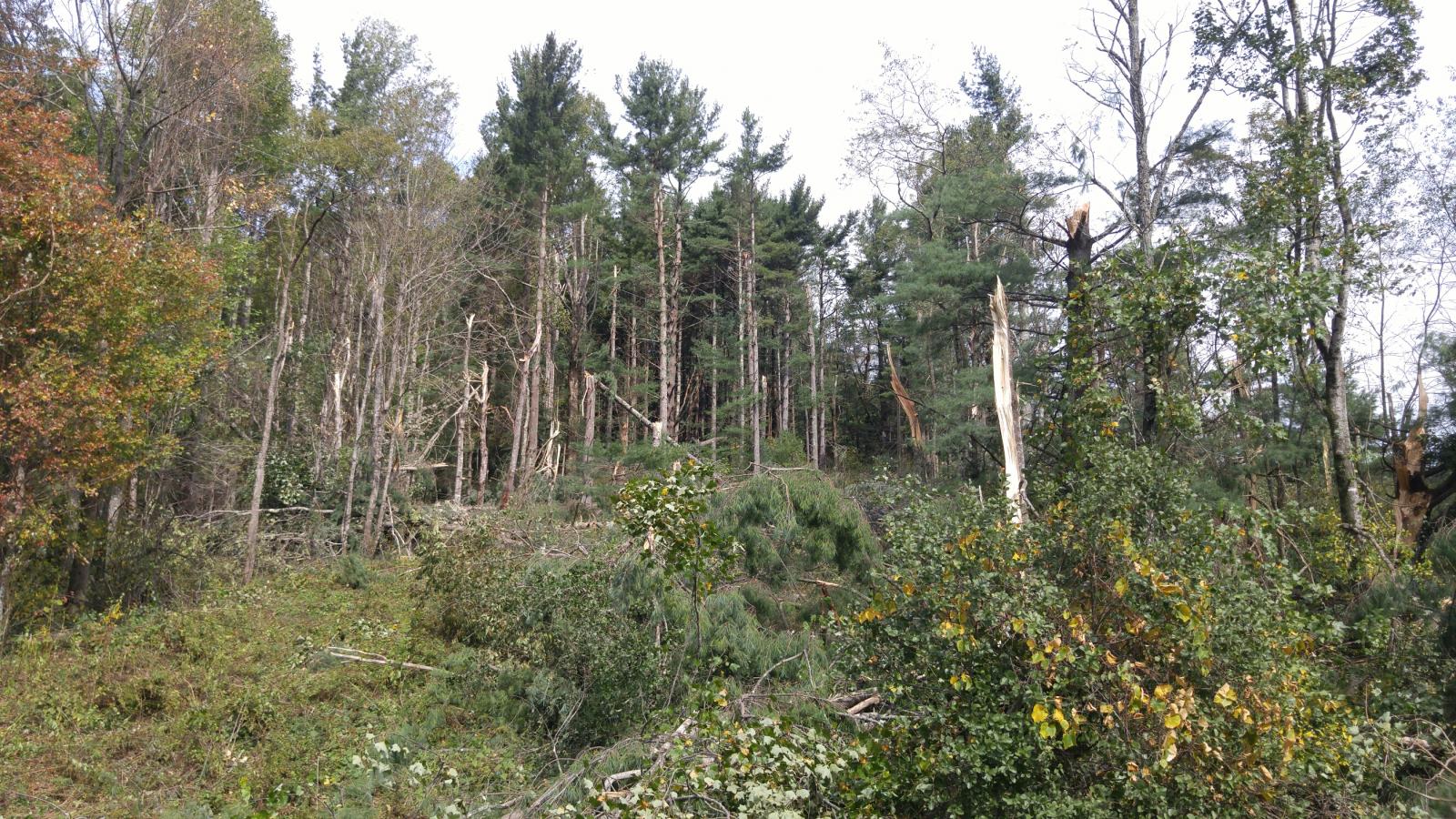
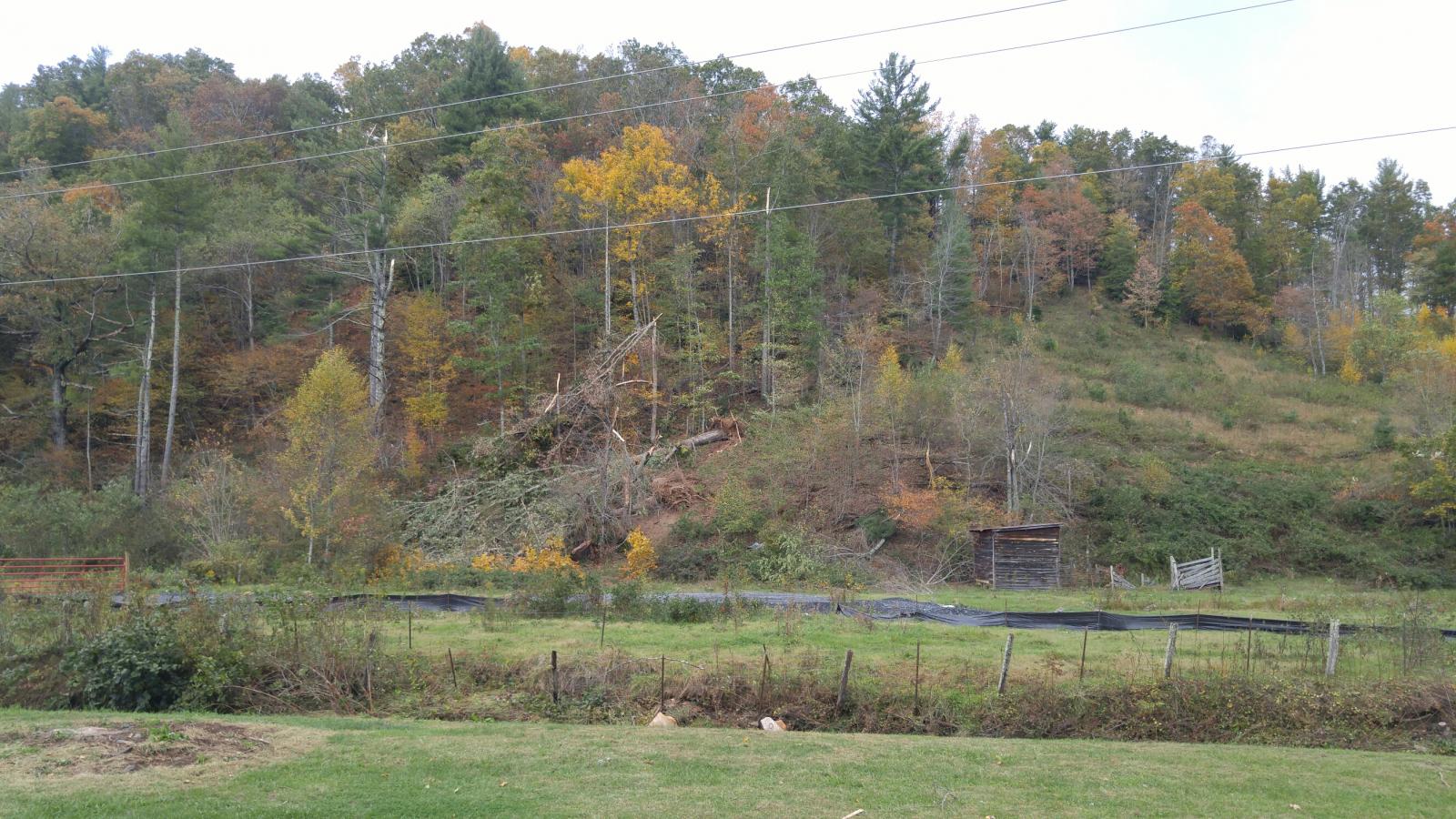
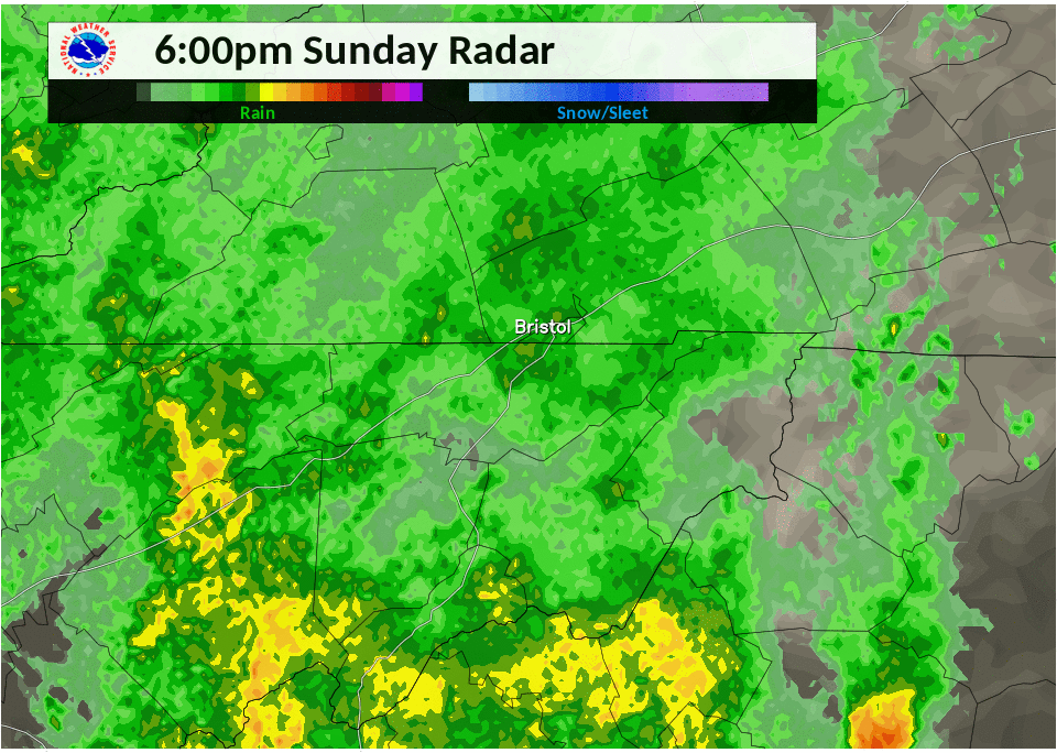
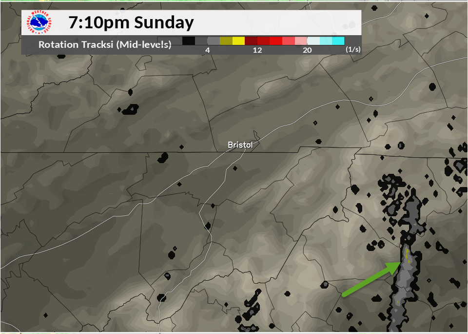
Tropical Depression Nate moved from the Tennessee Valley on the 8th into West Virginia during the morning of the 9th. A strong surge of tropical moisture and low level winds allowed for a band of showers/thunderstorms to track north over the Western Carolinas. One cell moved across western NC producing off and on damage from a tornado, including in Wilkes and Ashe Counties. In addition, an area of heavier rains brought urban flooding to the Boone, NC area during the evening of the 8th. Furthermore the stronger winds associated with Nate brought non thunderstorm wind damage to portions of southwest Virginia during the early morning of the 9th.
FACT : First recorded/documented tornado in Ashe County, NC since records began in 1950.
 |
 |
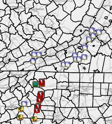 |
| Radar Loop of Tornadic Storm (cell on the right of loop) | Rotational Track of Tornado Producing Storm Oct 8th | Storm Reports from Oct 8th into early Oct 9th |
Click on the tabs below to review more information
Tornadoes:
|
|
||||||||||
|
||||||||||
|
Tornado - West of Harley, to Idlewild, NC
Track Map 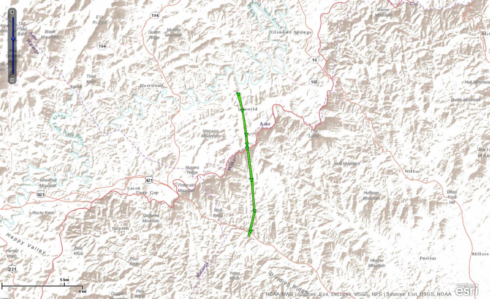
|
||||||||||||||||||||||||
The Enhanced Fujita (EF) Scale classifies tornadoes into the following categories:
| EF0 Weak 65-85 mph |
EF1 Moderate 86-110 mph |
EF2 Significant 111-135 mph |
EF3 Severe 136-165 mph |
EF4 Extreme 166-200 mph |
EF5 Catastrophic 200+ mph |
 |
|||||
Storm Reports
Tornado Reports
..TIME...   ...EVENT...      ...CITY LOCATION...     ...LAT.LON...
..DATE...   ....MAG....      ..COUNTY LOCATION..ST.. ...SOURCE....
            ..REMARKS..

0645 PM     TORNADO          5 ESE DEEP GAP          36.20N 81.43W
10/08/2017                   Wilkes             NC   NWS STORM SURVEY

            NUMEROUS 18-24 INCH TREES SNAPPED AND UPROOTED.

0650 PM     TORNADO          5 E DEEP GAP            36.24N 81.44W
10/08/2017                   Wilkes             NC   NWS STORM SURVEY

            NUMEROUS LARGE TREES SNAPPED. CEMENT TOP OF CHIMNEY
            KNOCKED OFF AND PART OF CHIMNEY CRUMBLED. MINOR ROOF
            DAMAGE TO 2 HOMES.

0657 PM     TORNADO          5 ENE DEEP GAP          36.26N 81.44W
10/08/2017                   Ashe               NC   NWS STORM SURVEY

            TREES DOWN ON THE BLUE RIDGE PARKWAY AND PHILLIPS GAP
            ROAD.

0700 PM     TORNADO          6 NE DEEP GAP           36.29N 81.44W
10/08/2017                   Ashe               NC   NWS STORM SURVEY

            TREE TRUNKS SNAPPED.
Tropical Wind Reports
..TIME...   ...EVENT...      ...CITY LOCATION...     ...LAT.LON...
..DATE...   ....MAG....      ..COUNTY LOCATION..ST.. ...SOURCE....
            ..REMARKS..

0435 AM     TROPICAL STORM   3 SW TAZEWELL           37.08N 81.55W
10/09/2017                   Tazewell           VA   911 CALL CENTER

            TREE DOWN PARTLY BLOCKING ROAD IN THOMPSON VALLEY, VA.
            TIME ESTIMATED.

0435 AM     TROPICAL STORM   5 ESE RICHLANDS         37.08N 81.71W
10/09/2017                   Tazewell           VA   911 CALL CENTER

            TREE DOWN BLOCKING ROUTE 460 IN POUNDING MILL. TIME
            ESTIMATED.

0458 AM     TROPICAL STORM   6 E HILLSVILLE          36.78N 80.63W
10/09/2017                   Carroll            VA   911 CALL CENTER

            CARROLL COUNTY 911 DISPATCH HAD 30 REPORTS OF TREES OR
            POWER LINES DOWNED COUNTY WIDE. SEVERAL ALONG THE
            PARKWAY. TRANSPORTATION NOT ADVERSELY IMPACTED. TIME
            ESTIMATED.

0500 AM     TROPICAL STORM   1 NNW BUCHANAN          37.53N 79.69W
10/09/2017                   Botetourt          VA   911 CALL CENTER

            BOTETOURT COUNTY 911 REPROTS SEVERAL TREES WERE DOWN
            EARLY THIS MORNING ON I-81 NEAR BUCHANAN THAT REQUIRED
            VDOT TEAMS TO CLEAR. TIME ESTIMATED FROM COUNTY DISPATCH
            REPORTS.

0500 AM     TROPICAL STORM   1 E ROCKY MOUNT         37.00N 79.87W
10/09/2017                   Franklin           VA   911 CALL CENTER

            TREE DOWN NEAR ROUTE 220 AND COURT ST NEAR ROCKY MOUNT.
            TIME ESTIMATED.

0500 AM     TROPICAL STORM   5 S WILLIS              36.78N 80.48W
10/09/2017                   Floyd              VA   911 CALL CENTER

            SEVERAL TREES DOWN ON BUFFALO MOUNTAIN ROAD. TIME
            ESTIMATED.

0502 AM     TROPICAL STORM   5 NNW ENDICOTT          36.94N 80.18W
10/09/2017                   Floyd              VA   911 CALL CENTER

            MULTIPLE TREES DOWN ALONG THE BLUE RIDGE PARKWAY IN PARTS
            OF FLOYD COUNTY. A TREE WAS ALSO REPORTED DOWNED ON
            SILVERLEAF ROAD CLOSE TO THE ENTRANCE TO THE PARKWAY.
            TIME ESTIMATED.

0502 AM     TROPICAL STORM   4 WSW COPPER HILL       37.06N 80.21W
10/09/2017                   Floyd              VA   911 CALL CENTER

            TREE DOWN ON SHAWSVILLE PIKE ROAD. TIME ESTIMATED.

0503 AM     TROPICAL STORM   3 WNW STEWARTSVILLE     37.28N 79.85W
10/09/2017                   Roanoke            VA   PARK/FOREST SRVC

            NUMEROUS TREES DOWN ALONG THE BLUE RIDGE PARKWAY

0600 AM     TROPICAL STORM   5 W GLASGOW             37.63N 79.54W
10/09/2017                   Rockbridge         VA   911 CALL CENTER

            TREE DOWN NEAR NATURAL BRIDGE. TIME ESTIMATED.

0615 AM     TROPICAL STORM   1 NNW COLLIERSTOWN      37.79N 79.59W
10/09/2017                   Rockbridge         VA   911 CALL CENTER

            FEW TREES DOWNED IN COLLIERSTOWN. TIME ESTIMATED FROM
            DISPATCH REPORTS.

0630 AM     TROPICAL STORM   2 E BUENA VISTA CITY    37.74N 79.33W
10/09/2017                   Rockbridge         VA   911 CALL CENTER

            TREES DOWNED IN BUENA VISTA. TIME ESTIMATED FROM DISPATCH
            REPORTS.

0703 AM     TROPICAL STORM   3 WNW FERRUM            36.94N 80.07W
10/09/2017                   Franklin           VA   911 CALL CENTER

            TREE DOWN ON TURNERS CREEK RD NEAR FERRUM. TREE WAS NOT
            LYING IN THE ROAD. TIME ESTIMATED FROM COUNTY DISPATCH
            CENTER.
Flood Report
..TIME...   ...EVENT...      ...CITY LOCATION...     ...LAT.LON...
..DATE...   ....MAG....      ..COUNTY LOCATION..ST.. ...SOURCE....
            ..REMARKS..

0749 PM     FLOOD            BOONE                   36.21N 81.67W
10/08/2017                   WATAUGA            NC   911 CALL CENTER

            MULTIPLE REPORTS OF URBAN FLOODING IN THE CITY OF BOONE.
Rain and Wind Reports
...Rainfall Reports...

Location                     Amount    Time/Date       Provider

...North Carolina...

...Alleghany County...
2 S Whitehead                7.21 in   0936 AM 10/09   CWOP
5 SW Sparta                  5.53 in   0959 AM 10/09   COCORAHS
Whitehead                    5.36 in   0758 AM 10/09   COCORAHS
1 WSW Barrett                5.03 in   0915 AM 10/09   HADS

...Ashe County...
2 NE Deep Gap                6.68 in   0700 AM 10/09   COCORAHS
Transou                      4.25 in   0800 AM 10/09   COOP
2 S Lansing                  3.97 in   0945 AM 10/09   CWOP
West Jefferson               3.82 in   0950 AM 10/09   CWOP
1 W Wagoner                  3.80 in   0645 AM 10/09   COCORAHS
Lansing Rg Dcp               3.67 in   0915 AM 10/09   GOES
1 SW Baldwin                 3.66 in   0800 AM 10/09   COCORAHS
2 SW Ashland                 2.29 in   0840 AM 10/09   COCORAHS

...Caswell County...
2 SSW Semora                 0.57 in   0730 AM 10/09   COCORAHS
1 NW Topnot                  0.53 in   0916 AM 10/09   RAWS
3 NNW Yanceyville            0.44 in   0800 AM 10/09   COCORAHS

...Rockingham County...
3 N Stokesdale               0.87 in   0937 AM 10/09   CWOP
Eden                         0.43 in   0629 AM 10/09   COOP
Reidsville 2 NW              0.33 in   0700 AM 10/09   COOP

...Stokes County...
Dan River At Pine Hall       1.35 in   0915 AM 10/09   GOES
Walnut Cove                  1.00 in   0700 AM 10/09   COCORAHS
Lawsonville                  0.96 in   0941 AM 10/09   CWOP
Danbury                      0.95 in   0700 AM 10/09   COOP
King                         0.91 in   0700 AM 10/09   COOP
2 SSW Ayersville             0.82 in   0920 AM 10/09   CWOP

...Surry County...
4 S Low Gap                  3.74 in   0917 AM 10/09   RAWS
Elkin                        3.37 in   0700 AM 10/09   COOP
1 SSE Dobson                 2.35 in   0948 AM 10/09   CWOP
2 NNW Flat Rock              1.96 in   0946 AM 10/09   CWOP
Ararat River At Ararat       1.81 in   0935 AM 10/09   GOES
Pilot Mountain               1.69 in   0700 AM 10/09   COCORAHS
2 NNW Pilot Mountain         1.64 in   0941 AM 10/09   CWOP

...Watauga County...
2 W Blowing Rock             6.44 in   0949 AM 10/09   CWOP
3 SSE Foscoe                 6.43 in   0947 AM 10/09   CWOP
1 E Seven Devils             6.14 in   0645 AM 10/09   COCORAHS
Aho                          6.01 in   0700 AM 10/09   COCORAHS
1 SW Aho                     5.92 in   0800 AM 10/09   COCORAHS
1 SE Rutherwood              5.58 in   0800 AM 10/09   COCORAHS
Boone Precip (tva) 2s        5.52 in   0915 AM 10/09   GOES
1 ESE Boone                  5.47 in   0755 AM 10/09   AWOS
1 SSW Aho                    5.40 in   0720 AM 10/09   COCORAHS
Seven Devils                 5.24 in   0800 AM 10/09   COCORAHS
Boone                        4.97 in   0730 AM 10/09   COCORAHS
Boone 1se                    4.66 in   0635 AM 10/09   COOP
1 N Foscoe                   4.60 in   0800 AM 10/09   COCORAHS
1 E Silverstone              4.06 in   0929 AM 10/09   CWOP
Boone                        4.01 in   0944 AM 10/09   CWOP
Valle Crucis                 3.87 in   0700 AM 10/09   COCORAHS
Watauga River                3.52 in   0930 AM 10/09   GOES
1 SE Beech Mountain          3.18 in   0630 AM 10/09   COCORAHS
1 NNW Beech Mountain         2.76 in   0939 AM 10/09   CWOP
2 SSW Rominger               1.06 in   0950 AM 10/09   CWOP

...Wilkes County...
North Wilkesboro 0.4 S       3.49 in   0854 AM 10/09   COCORAHS
North Wilkesboro             3.27 in   0700 AM 10/09   COOP
2 SSE Wilbar                 2.72 in   0910 AM 10/09   RAWS
2 SSE Buck                   2.55 in   0845 AM 10/09   HADS
Elkville-elk Creek           2.32 in   0845 AM 10/09   GOES
2 E Dockery                  2.15 in   1103 PM 10/08   CWOP

...Yadkin County...
Yadkinville                  1.92 in   0700 AM 10/09   COCORAHS
Yadkinville 6 E              1.40 in   0700 AM 10/09   COOP

...Virginia...

...Alleghany County...
3 S Hollins                  2.70 in   0700 AM 10/09   COCORAHS
2 NNE Natural Well           2.07 in   0930 AM 10/09   HADS
Gathright Dam                1.92 in   0700 AM 10/09   COOP

...Amherst County...
Pedlar Dam                   1.40 in   0830 AM 10/09   COOP
1 SW Amherst                 0.79 in   0800 AM 10/09   COCORAHS

...Appomattox County...
Appomattox                   0.54 in   0800 AM 10/09   COOP

...Bath County...
Hot Springs                  2.60 in   0800 AM 10/09   COOP
4 E Hot Springs              2.49 in   0901 AM 10/09   RAWS
7 NE Mountain Grove          2.44 in   0930 AM 10/09   HADS
Mountain Grove               2.02 in   0700 AM 10/09   COOP
Millboro                     1.74 in   0700 AM 10/09   COCORAHS
1 NNW Bacova Junction        1.70 in   0930 AM 10/09   HADS

...Bedford County...
3 SSE Buchanan               1.25 in   0949 AM 10/09   CWOP
Holcomb Rock                 1.21 in   0630 AM 10/09   COOP
3 SW Moneta                  1.19 in   0800 AM 10/09   COCORAHS
Boonsboro                    1.01 in   0942 AM 10/09   CWOP
3 SSW Moneta                 0.98 in   0800 AM 10/09   COCORAHS
Chamblissburg                0.83 in   0700 AM 10/09   COCORAHS
Moneta                       0.80 in   0947 AM 10/09   CWOP

...Bland County...
3 SE Suiter                  2.41 in   0948 AM 10/09   CWOP
1 NNW Bland                  2.06 in   0915 AM 10/09   VADOT
Bland                        0.76 in   0930 AM 10/09   HADS

...Botetourt County...
6 W Fincastle                1.90 in   0947 AM 10/09   CWOP
1 WNW Buchanan               1.74 in   0930 AM 10/09   VADOT
2 E Lithia                   1.06 in   0950 AM 10/09   CWOP

...Buckingham County...
Bremo Bluff                  0.33 in   0509 AM 10/09   COOP

...Campbell County...
2 NE Evington                1.18 in   0830 AM 10/09   COCORAHS
Lynchburg Regional Airport   0.92 in   0754 AM 10/09   ASOS
1 ESE Bocock                 0.77 in   0700 AM 10/09   COCORAHS
Gladys                       0.70 in   0700 AM 10/09   COCORAHS
Concord 4 SSW                0.55 in   0700 AM 10/09   COOP
Brookneal                    0.52 in   0930 AM 10/09   COOP

...Carroll County...
Laurel Fork                  3.68 in   0915 AM 10/09   HADS
2 SSE Byllesby               2.18 in   0700 AM 10/09   COCORAHS

...Charlotte County...
2 ENE Wren                   0.29 in   0950 AM 10/09   CWOP

...City of Buena Vista County...
Buena Vista                  0.82 in   0700 AM 10/09   COOP

...City of Covington...
Covington Filter Plant       1.96 in   0715 AM 10/09   COOP

...City of Danville County...
Danville Regional Airport    0.54 in   0753 AM 10/09   ASOS

...City of Galax...
Galax Water Plant            3.04 in   0700 AM 10/09   COOP

...City of Lynchburg...
2 NE Lynchburg Airport       0.80 in   0930 AM 10/09   VADOT

...City of Martinsville...
Martinsville Filter Plant    1.09 in   0700 AM 10/09   COOP

...City of Radford...
Radford                      2.19 in   0520 AM 10/09   COCORAHS

...City of Roanoke...
1 SW Roanoke                 1.25 in   0950 AM 10/09   CWOP
Roanoke Regional Airport     1.19 in   0754 AM 10/09   ASOS
2 SE Roanoke                 0.72 in   0945 AM 10/09   CWOP

...Craig County...
2 ENE New Castle             2.38 in   0907 AM 10/09   RAWS

...Floyd County...
2 ESE Willis                 2.53 in   0700 AM 10/09   COCORAHS
ALum RIdge                   2.50 in   0830 AM 10/09   SPOTTER
Willis                       2.23 in   0845 AM 10/09   GOES
Willis                       1.92 in   0700 AM 10/09   COOP

...Franklin County...
2 WNW Rocky Mount            1.57 in   0626 AM 10/09   COCORAHS
3 NE Penhook                 1.14 in   0947 AM 10/09   CWOP
3 SW Moneta                  1.13 in   0946 AM 10/09   CWOP
3 SW Moneta                  1.07 in   0944 AM 10/09   CWOP
3 N Penhook                  0.99 in   0700 AM 10/09   COCORAHS
3 S Goodview                 0.99 in   0800 AM 10/09   COCORAHS
4 S Goodview                 0.96 in   0800 AM 10/09   COCORAHS
2 SSE Wirtz                  0.93 in   0949 AM 10/09   CWOP
5 SSW Moneta                 0.89 in   0630 AM 10/09   COCORAHS
3 SSW Stewartsville          0.81 in   0944 AM 10/09   CWOP

...Giles County...
3 W Thessalia                1.99 in   0913 AM 10/09   RAWS
Staffordsville 3 ENE         1.85 in   0700 AM 10/09   COOP
1 NNE Pembroke               1.57 in   0700 AM 10/09   COCORAHS
1 NNE Pembroke               1.47 in   0949 AM 10/09   CWOP

...Grayson County...
2 NE Baywood                 2.37 in   0930 AM 10/09   HADS
Volney                       1.99 in   0930 AM 10/09   GOES
Independence                 1.93 in   0735 AM 10/09   COCORAHS

...Halifax County...
Roanoke R.  (staunton River) 0.33 in   0845 AM 10/09   GOES
1 NNW South Boston           0.25 in   0943 AM 10/09   CWOP
South Boston                 0.23 in   0700 AM 10/09   COOP
3 N Buffalo Springs          0.04 in   0939 AM 10/09   CWOP

...Henry County...
Philpott Reservoir At Philpo 1.43 in   0845 AM 10/09   GOES
Martinsville                 1.15 in   0755 AM 10/09   AWOS

...Montgomery County...
Blacksburg NWS               2.79 in   0700 AM 10/09   COOP
3 NNE Blacksburg             2.78 in   0941 AM 10/09   CWOP
Blacksburg                   2.74 in   0755 AM 10/09   AWOS
Blacksburg 0.4 N             2.63 in   0700 AM 10/09   COCORAHS
1 ESE Christiansburg         2.47 in   0710 AM 10/09   COCORAHS
1 ENE Blacksburg             2.37 in   0700 AM 10/09   COCORAHS
3 WNW Pilot                  2.00 in   0940 AM 10/09   CWOP
1 WNW Prices Fork            1.87 in   0800 AM 10/09   COCORAHS
2 NW Blacksburg              1.53 in   0946 AM 10/09   CWOP
1 N Elliston-Lafayette       1.41 in   0943 AM 10/09   CWOP

...Patrick County...
Meadows Of Dan 5sw           4.28 in   0700 AM 10/09   COOP
4 SSW Meadows Of Dan         4.14 in   0700 AM 10/09   COCORAHS
3 WNW Charity                2.29 in   0800 AM 10/09   COCORAHS
Stuart                       1.90 in   0700 AM 10/09   COOP

...Pittsylvania County...
Chatham                      0.98 in   0700 AM 10/09   COOP
2 ESE Ringgold               0.86 in   0936 AM 10/09   CWOP

...Pulaski County...
1 NW Copper Valley           2.36 in   0950 AM 10/09   CWOP
Fairlawn                     2.25 in   0700 AM 10/09   COCORAHS
Radford                      2.21 in   0915 AM 10/09   HADS
2 S Dublin                   1.70 in   0730 AM 10/09   COCORAHS
Dublin                       1.08 in   0755 AM 10/09   AWOS
Dublin                       0.30 in   0920 AM 10/09   VADOT

...Roanoke County...
1 NNE Bent Mountain          2.09 in   0949 AM 10/09   CWOP
1 W Cave Spring              1.80 in   0700 AM 10/09   COCORAHS
1 S Cave Spring              1.67 in   0949 AM 10/09   CWOP
Roanoke Airport              1.62 in   0902 AM 10/09   CWOP
2 SW Laymantown              0.95 in   0948 AM 10/09   CWOP

...Rockbridge County...
Glasgow 1 SE                 2.11 in   0700 AM 10/09   COOP
4 SW Collierstown            1.69 in   0700 AM 10/09   COCORAHS
2 E Natural Bridge           1.54 in   0942 AM 10/09   RAWS
5 W Cornwall                 1.02 in   0938 AM 10/09   CWOP
1 WSW Vesuvius               0.96 in   0940 AM 10/09   CWOP

...Smyth County...
Konnarock                    2.44 in   0915 AM 10/09   GOES
Saltville                    2.36 in   0845 AM 10/09   TVA
Marion Tva Rg                1.65 in   0930 AM 10/09   GOES
1 N Adwolf                   1.55 in   0947 AM 10/09   CWOP
1 NE Marion                  1.54 in   0800 AM 10/09   COCORAHS
1 NE Marion                  1.48 in   0948 AM 10/09   CWOP
Marion/wytheville            1.35 in   0755 AM 10/09   AWOS

...Tazewell County...
Burkes Garden                2.41 in   0630 AM 10/09   COOP
4 SSW Bluefield              2.31 in   0915 AM 10/09   HADS
Bluefield                    1.53 in   0945 AM 10/09   CWOP
Burkes Garden                1.48 in   0945 AM 10/09   CWOP
3 WNW Tazewell               1.33 in   0830 AM 10/09   COCORAHS
2 S Richlands                1.09 in   0755 AM 10/09   AWOS

...Wythe County...
3 N Favonia                  2.19 in   0858 AM 10/09   RAWS
Wytheville 1 S               2.18 in   0740 AM 10/09   COOP
Wytheville                   1.85 in   0947 AM 10/09   CWOP
1 NW Patterson               1.70 in   0937 AM 10/09   CWOP

...West Virginia...

...Greenbrier County...
Knob                         2.57 in   0900 AM 10/09   GOES
Maxwelton                    1.87 in   0945 AM 10/09   CWOP
Mcross 3e                    1.57 in   0700 AM 10/09   COOP
Greenbrier Valley Airport    1.51 in   0755 AM 10/09   AWOS
White Sulphur Springs        1.40 in   0700 AM 10/09   COOP
Rainelle                     1.37 in   0845 AM 10/09   USARMY-COE
White Sulphur Springs        1.27 in   0845 AM 10/09   GOES

...Mercer County...
East River Stream/rain Gage  1.68 in   0915 AM 10/09   GOES
1 W Camp Creek               1.52 in   0930 AM 10/09   HADS
Mercer County Airport        1.22 in   0752 AM 10/09   ASOS
Bluefield                    1.19 in   0950 AM 10/09   CWOP
Princeton                    0.96 in   0700 AM 10/09   COOP
1 E Camp Creek               0.33 in   0920 AM 10/09   WVDOT

...Monroe County...
Alderson                     1.65 in   0800 AM 10/09   COOP
Rock Camp                    1.25 in   0830 AM 10/09   GOES

...Summers County...
Bluestone Lake               1.52 in   0700 AM 10/09   COOP
1 WSW Pipestem               1.30 in   0917 AM 10/09   RAWS
Bluestone River Nr Pipestem  0.32 in   0900 AM 10/09   GOES
...Wind Reports...

Location                     Speed     Time/Date       Elevation (ft.)

...North Carolina...

...Alleghany County...
Barrett                      47 MPH    0945 PM 10/08   2990
2 S Whitehead                42 MPH    0805 PM 10/08   3554

...Ashe County...
Jefferson                    31 MPH    0810 PM 10/08   3028
2 S Lansing                  31 MPH    0943 PM 10/08   2901
West Jefferson               30 MPH    0715 PM 10/08   2897
1 SSE Jefferson              19 MPH    0830 PM 10/08   4608

...Caswell County...
1 NW Topnot                  22 MPH    0416 AM 10/09   580

...Rockingham County...
4 ESE Stoneville             18 MPH    0900 AM 10/09   692
3 N Stokesdale               13 MPH    0622 AM 10/09   890

...Stokes County...
Lawsonville                  33 MPH    0318 AM 10/09   98
2 SSW Ayersville             27 MPH    0320 AM 10/09   950

...Surry County...
Mount Airy                   28 MPH    0205 AM 10/09   1197
2 NNW Pilot Mountain         24 MPH    1225 AM 10/09   1128
1 SSE Dobson                 24 MPH    0432 AM 10/09   1166
2 NNW Flat Rock              21 MPH    1116 PM 10/08   1223
4 S Low Gap                  21 MPH    1017 PM 10/08   1299

...Watauga County...
1 E Silverstone              54 MPH    0114 AM 10/09   5151
2 SSW Rominger               49 MPH    0719 PM 10/08   4908
3 SSE Foscoe                 36 MPH    0716 PM 10/08   3599
1 ESE Boone                  36 MPH    1255 AM 10/09   3146
Boone                        33 MPH    1228 AM 10/09   3300


...Wilkes County...
2 SSE Wilbar                 30 MPH    0210 AM 10/09   2383
North Wilkesboro             29 MPH    0440 AM 10/09   1200
Wilkesboro                   27 MPH    1234 AM 10/09   1112
4 WNW Windy Gap              24 MPH    1241 AM 10/09   1158
2 E Dockery                  18 MPH    1003 PM 10/08   1082

...Virginia...

...Alleghany County...
3 NNW Covington City         12 MPH    1008 PM 10/08   1266
3 SE Hollins                 10 MPH    1250 AM 10/09   1245

...Appomattox County...
Appomattox                   23 MPH    0715 AM 10/09   839
Appomattox                   11 MPH    0600 AM 10/09   801

...Bath County...
Ingalls Field                35 MPH    0555 AM 10/09   3793
4 E Hot Springs              30 MPH    0401 AM 10/09   2580

...Bedford County...
3 SSE Buchanan               30 MPH    0106 AM 10/09   1299
Moneta                       22 MPH    0707 AM 10/09   967
Bedford City                 11 MPH    0620 AM 10/09   900
Boonsboro                    10 MPH    0226 AM 10/09   882

...Bland County...
3 SE Suiter                  23 MPH    0828 PM 10/08   2752
1 NNW Bland                  12 MPH    1045 PM 10/08   2668

...Botetourt County...
1 WNW Buchanan               31 MPH    0400 AM 10/09   895
2 E Lithia                   26 MPH    0219 AM 10/09   1361
1 E Springwood               17 MPH    0139 AM 10/09   1257
1 NNW Eagle Rock             13 MPH    0209 AM 10/09   1257

...Buckingham County...
Buckingham                   12 MPH    0334 AM 10/09   505

...Campbell County...
Lynchburg Regional Airport   28 MPH    0454 AM 10/09   940

...Carroll County...
Galax Hillsville             43 MPH    0155 AM 10/09   2634
2 N Fancy Gap                15 MPH    0302 AM 10/09   2898

...Charlotte County...
2 ENE Wren                   20 MPH    0520 AM 10/09   698

...City of Danville...
Danville Regional Airport    18 MPH    0853 AM 10/09   571
1 WSW Danville Airport       15 MPH    0404 PM 10/08   600

...City of Lynchburg...
2 NE Lynchburg Airport       39 MPH    0115 AM 10/09   824

...City of Martinsville...
Martinsville City            11 MPH    0710 AM 10/09   1025

...City of Radford...
Radford                      17 MPH    0330 AM 10/09   1825

...City of Roanoke...
2 SE Roanoke                 46 MPH    0230 AM 10/09   1499
Roanoke Regional Airport     32 MPH    0408 AM 10/09   1149
1 SW Roanoke                 21 MPH    0100 AM 10/09   1043
1 E Roanoke                  18 MPH    0349 AM 10/09   999

...City of Salem...
1 E Salem City               12 MPH    0224 AM 10/09   1145

...Craig County...
2 ENE New Castle             12 MPH    0607 AM 10/09   1490

...Franklin County...
3 NE Penhook                 28 MPH    0822 PM 10/08   823
3 SW Moneta                  25 MPH    0353 AM 10/09   830
3 SSW Stewartsville          23 MPH    0154 AM 10/09   928
2 SSE Wirtz                  21 MPH    0429 AM 10/09   1138
3 SW Moneta                  21 MPH    0619 AM 10/09   791
Rocky Mount                  16 MPH    0340 AM 10/09   1184
4 NNE Penhook                15 MPH    0702 AM 10/09   840
1 NW Rocky Mount             13 MPH    0634 AM 10/09   1132

...Giles County...
Bald Knob/Mountain Lake      38 MPH    0218 AM 10/09   3428
3 W Thessalia                24 MPH    0413 AM 10/09   4100
1 NNE Pembroke               16 MPH    0658 PM 10/08   1889

...Grayson County...
1 NNW Elk Creek              26 MPH    0908 PM 10/08   2805

...Halifax County...
3 N Buffalo Springs          20 MPH    0508 AM 10/09   347
1 NNW South Boston           12 MPH    0327 AM 10/09   355

...Henry County...
Martinsville                 25 MPH    0655 AM 10/09   902

...Montgomery County...
Blacksburg                   23 MPH    0415 AM 10/09   2100
4 E Childress                22 MPH    0303 AM 10/09   2080
3 WNW Pilot                  19 MPH    0410 AM 10/09   1935
3 NNE Blacksburg             17 MPH    0125 AM 10/09   2319
2 NW Blacksburg              13 MPH    0341 AM 10/09   2120

...Pittsylvania County...
2 ESE Ringgold               17 MPH    0201 AM 10/09   492

...Pulaski County...
1 NW Copper Valley           33 MPH    0230 AM 10/09   2460
Dublin                       29 MPH    0335 AM 10/09   2067
Dublin                       27 MPH    0400 AM 10/09   2116

...Roanoke County...
1 NNE Bent Mountain          29 MPH    1033 PM 10/08   2750
1 W Poages Mill              29 MPH    0109 AM 10/09   1496
2 SW Laymantown              27 MPH    0117 AM 10/09   1250
Roanoke Airport              22 MPH    0140 AM 10/09   1161
1 S Cave Spring              21 MPH    0359 AM 10/09   1279

...Rockbridge County...
1 WSW Vesuvius               43 MPH    0507 AM 10/09   1656
5 W Cornwall                 22 MPH    0458 AM 10/09   1086
2 E Natural Bridge           13 MPH    0542 AM 10/09   865
2 ENE Collierstown           12 MPH    0620 AM 10/09   1312
5 NE Collierstown            10 MPH    0249 AM 10/09   1063

...Smyth County...
Marion/wytheville            25 MPH    0815 AM 10/09   2500
1 NE Marion                  14 MPH    0323 PM 10/08   2263
1 N Adwolf                   12 MPH    0547 PM 10/08   2175

...Tazewell County...
Burkes Garden                36 MPH    0529 AM 10/09   3087
2 S Richlands                29 MPH    0755 PM 10/08   2654
Bluefield                    25 MPH    0855 PM 10/08   2398
1 ENE Tazewell               20 MPH    0725 PM 10/08   2461
4 SW Claypool Hill           17 MPH    1229 AM 10/09   2370

...Wythe County...
1 NW Patterson               19 MPH    0237 AM 10/09   2240
3 N Favonia                  15 MPH    0958 PM 10/08   2540
Wytheville                   14 MPH    0807 PM 10/08   2391

...West Virginia...

...Greenbrier County...
Greenbrier Valley Airport    18 MPH    1235 AM 10/09   2244
Maxwelton                    13 MPH    0330 AM 10/09   2270

...Mercer County...
Mercer County Airport        37 MPH    0906 PM 10/08   2870
Bluefield                    17 MPH    0458 AM 10/09   2677
1 E Camp Creek               16 MPH    0735 AM 10/09   2081

...Summers County...
1 WSW Pipestem               16 MPH    0817 AM 10/09   2725

&&

Observations are collected from a variety of sources with varying
equipment and exposures. We thank all volunteer weather observers
for their dedication. Not all data listed are considered official.
 |
Media use of NWS Web News Stories is encouraged! Please acknowledge the NWS as the source of any news information accessed from this site. |
|