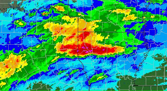
National Weather Service United States Department of Commerce

Severe Thunderstorms Move into the Midwest and Ohio Valley; High Winds in the High Plains

An Enhanced Risk (Level 3 of 5) for scattered severe thunderstorms has been outlooked across the Ohio Valley today. Tornadoes, hail, and damaging winds possible. Farther west on the back side of the storm system driving the severe thunderstorms, strong winds and critical fire weather will affect the High Plains and parts of the Rockies through midweek, along with heavy snow in the high Rockies. Read More >

Overview
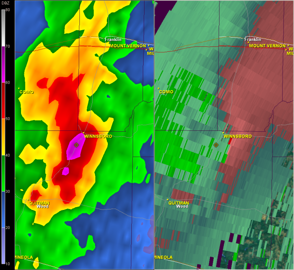
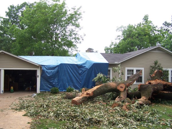
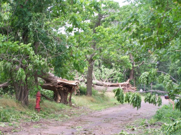
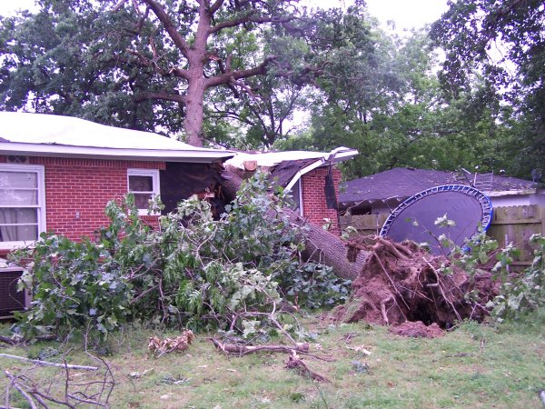
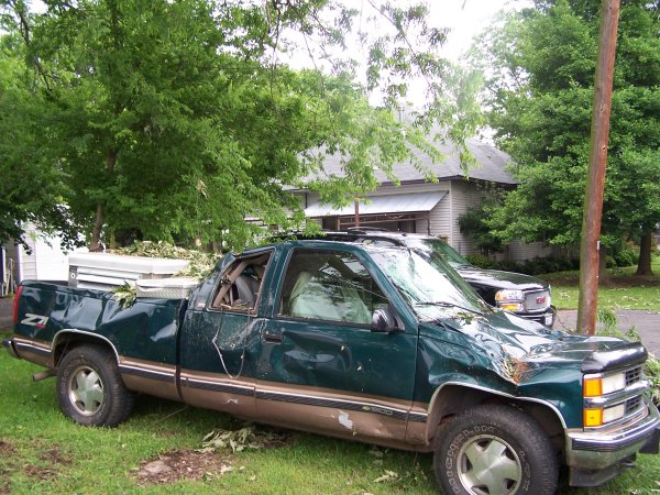
A severe weather event unfolded across the Four State Region on May 14th-15th, 2008. Straight-line winds, a tornado, and flooding occurred. A significant straight-line wind event with wind speeds of 90 to 100 mph, and an EF1 tornado with winds of 95 to 105 mph occurred in Winnsboro, TX, in Wood and Franklin Counties between 12:50am and 1:00am CDT on Thursday, May 15th.

TOTAL TORNADO COUNT = 1

EF1 = 1
 
TOR. # START POINT END
POINT
RATING PEAK WIND START TIME END TIME LENGTH/
WIDTH
FATALITIES/
INJURIES
REMARKS
MAY 15, 2008
#1  NW of Winnsboro, Wood County, TX Franklin County, TX EF1 95-105 mph 12:50am CDT 1:00am CDT 3 miles/
100 yards
None This tornado began on the northwest side of Winnsboro along Hwy 11 and tracked eastward crossing Greenwood Street where a mobile home sustained minor damage. The tornado continued eastward crossing Hwy 27 where several large trees were snapped and uprooted. The tornado headed eastward crossing FM 1448 snapping and uprooted a few trees before lifting.

This appears to have been a book-end tornado that formed on the northern edge of the straight-line winds that moved through the town of Winnsboro.
  Winnsboro, Wood County, TX Near Winnsboro, Franklin County, TX Straight-line winds 90-100 mph 12:50am CDT 1:00am CDT n/a None Widespread straight-line wind damage was found as numerous homes were damaged through Winnsboro and the surrounding area from falling trees. Some of them were severely damaged. As a result of the trees downed, water lines into the area were broken and power outages were widespread. Numerous cars were also severely damaged in Winnsboro due to falling trees. Several cattle were killed west of Winnsboro near the Hopkins and Wood County line at some dairy farrms due to falling trees, and several cattle were reported as missing.

A significant number of trees were also downed in Hopkins County along County Roads 2408, 2403, and 2407 just north of the Wood and Hopkins County line. East of Winnsboro, numerous trees were downed in Wood County along Hwy 11 and FM 852 including the town of Perryville where trees were downed around the fire station and around several homes.

Widespread flooding was reported throughout Shreveport and Bossier City. Numerous cars, businesses, and homes had taken on water throughout the day. Interstate 20 was shut down for a short period in west Shreveport due to high water.

The Automatic Surface Observing Station at Shreveport Regional Airport recorded 10.73 inches of rainfall from 6pm on May 13th through 1pm on May 14th becoming the second highest 24-hour rainfall total since 1873. 12.44 inches of rainfall in July 1933 was the record.

Some of the impacts included:

  • Numerous homes in the Shreveport-Bossier City area were flooded requiring high water rescues by boats in many subdivisions (numbers unknown).
  • Hundreds of cars (total count unknown) were/are flooded and abandoned on roadways/medians throughout the city making travel more difficult.
  • Numerous roads were closed throughout the city including two locations on Interstate 20.
  • LSU Medical Center reported five feet of water in their basement, which required pumps. Total damage unknown.
  • Water main breaks occurred in south Shreveport causing water problems in numerous subdivisions, as well as a boil advisory (including some businesses and hospitals).
  • Will-Knight Hospital was closed due to flooding and the water problems. Emergency services were diverted.
  • Caddo Parish schools were closed early due to flooding and water problems.
  • Accidents were reported all over the city due to high water and power outages at intersections.width from one end of the damage swath to the other.
24-Hour rainfall totals ending at 7am on May 14, 2008
24-Hour Rainfall Totals ending at 7am on May 14th, 2008, showing the 6-10 inches that fell across Northwest Louisiana.
 
 
Radar imagery of the tornado near Winnsboro
Radar imagery of the tornado near Winnsboro.
 
Damage to a home in Winnsboro
Damage to a house in Winnsboro in Wood County where a tree had fallen on it.


Damage to a home in Winnsboro
The area on Greenwood Street where the tornado went through.
     
Damage to a home in Winnsboro
Another tree cutting into a house on the north side of Winnsboro caused by the straight-line winds.
 
A truck in Winnsboro was damaged by a falling tree
A truck damaged by a falling tree in Winnsboro.
 
Click here to download the survey KMZ file.
This survey data is preliminary and subject to change as more information becomes available.  Road accessibility and inconsistencies between mapping and GPS software may limit the accuracy of the tracks plotted on this map. Line widths are not representative of actual tornado widths.  The information plotted on this map is intended for general reference use only.

For official post-storm information, use 
Storm Data from the National Centers for Environmental Information.
Back to Top